 OpenStreetMap

Story
Users' Diaries
Recent diary entries
Lini masa sejak Januari hingga Agustus
Apalah
Posted by Vendetta Cartel on 24 August 2026 in Italian (Italiano).

Casale Cima
Santa Cristina fraz. di Borgomanero (NO) 28021, Piemonte
24/08/2026, San Bartolomeo
E’ il santo patrono di Borgomanero e Santa Cristina, essendo che si festeggia il 24 luglio, non dovrebbe c’entrare niente, invece le pochissime attività e servizi pubblici sono chiusi anche oggi.
C’è da dire che ho apportato un po’ di modifiche alla mappa del territorio locale, oggi. Munita di mappali del Catasto di Novara, comune di Borgomanero, Foglio: 21 e Particelle: varie (es.: 191 - 193-194, etc.) ed in territorio di Gattico-Veruno, Foglio: 1, sono riuscita a ricollocare esattamente i confini dei nostri terreni, discendenti dei fratelli Valsesia Angelo Maria e Carlo, i quali avevano acquistato l’intera cascina, con tutto il territorio annesso, nel secolo scorso, dai conti Busti, a loro volta eredi dei nobili possidenti Morbio-Zapelono. Il conte Paolo Busti, a fine 1800, fece costruire le “case masserezze” per i fittavoli che lavoravano le terre, area denominata poi “La Moretta”. Casa mia era detta la Ca’ Nova, poiché era l’unica non annessa al casale vero e proprio, essendo infatti una casa indipendente con giardino, costruita intorno al 1960 e non risalente al 1700 come gli edifici adibiti ad abitazione e quelli usati come stalle e fienili del Casale Cima, originariamente chiamato Sopramonte, per il rilievo su cui si colloca.

Thanks to the work of several contributors, the usage of name:fur tag in OpenStreetMap is constantly increasing and there is now a pretty good coverage of Friuli region at place level (and even down to street-level in some parts of it). This tag represents a name in Friulian language, mainly spoken in north-east Italy.
This tag is visible today in a dedicated rendering (which I created) on mapefurlane.eu and in the various multi-lingual maps like the great Americana.
Apart from the maps, another interesting use of this data is to have lists of toponyms. For Friulian language, there is already a list provided by an official organization, but besides not being very detailed, it’s also quite static (PDF). So I wanted to have something better than that by leveraging all OSM data.
My main goal then was to create a searchable web page that could show the toponyms of Friuli historical region, not only in Friulian, but also in all recognized languages, i.e. Friulian, Italian, German and Slovenian. The list should be updated automatically from OSM data.
What is DuckDB
DuckDB is an open source in-process SQL OLAP database management system. It has a builtin spatial extension that can import PBF files which can be then queried using SQL syntax.
Using DuckDB with OpenStreetmap
Since I already had a daily pipeline (GitHub Action) to update Mape Furlane that used a PBF extract as input, integrating DuckDB there was immediate: just adding the single binary, loading the PBF and then all the data was available for querying.
From that I added a few SQL queries visible on https://github.com/andreadecorte/mapefurlane/tree/main/scripts/duckdb that generate 2 output files: 1. all places with name:fur tag and all the other name: tags (name:it, name:de, name:sl) 2. all places in the area without a name:fur tag with a Markdown output (to help increase the coverage)
Kurnus

Doom Scrolling through aerial images of Canada revealed this to me:

And for a millisecond I wondered how this could be mapped. Maybe tourism=attraction? 🤪
Letztens beim Doom-Scrolling über die OSM-Karte in Oschersleben einen langen grünen Strich gesehen und gedacht, “okay, lange Hecke oder was?”

Oder wieder Vandalismus a.k.a. FCK.PTN?
Beim Editieren habe ich dann gesehen, dass jemand den Anfang der Hecke wohl versehentlich weit weg verschoben hat. Ich konnte die Hecke dann reparieren: osm.org/way/301454013
Posted by Calvin Menttor on 22 August 2026 in English.

Being a YouthMapper?
Posted by Outback-Lindlar on 22 August 2026 in German (Deutsch).
Willkommen im Outback-Lindlar!
Ab sofort ist das Outback-Lindlar (Klauserstraße 77 in 51789 Lindlar) auch auf OpenStreetMap präsent. Als gemütliches Themenrestaurant im Bergischen Land freuen wir uns über alle Gäste, Tourenfahrer und Biker, die bei uns einen Zwischenstopp einlegen.
Kommt vorbei auf gute Küche, erfrischende Drinks und eine tolle Atmosphäre. Schaut gerne rein!

My Google Summer of Code 2026 project was Category Support in Nominatim.
The goal was to replace Nominatim’s single class/type representation with a proper categories field so that one OSM object can carry multiple categories. For eg, an object tagged as both a hotel and a restaurant can now be represented in one row with categories such as:
osm.tourism.hotel
osm.amenity.restaurant
What was completed
- Added the PostgreSQL
ltree[]categories column to the main Nominatim tables. - Generated multiple categories from OSM tags during import while keeping the existing
classandtypefields for compatibility. - Updated ranking, triggers, migrations, and related database logic to use categories.
- Replaced the old
place_classtype_*search tables with category-based search using indexed queries. - Removed the old
place_classtype_*table creation and maintenance code. - Added category filters to the search API.
- Updated the SQLite adaptor and tests for category data.
- Updated the documentation for the category system and its API behaviour.
Pull requests
- #4106: Add ltree categories column for multi-tag OSM object support - merged
- #4146: Use ltree categories column instead of place_classtype tables - merged
- #4163: Remove the place_classtype tables - merged
- #4164: Add category filters to the search API - merged
- #4166: Update the documentation for the category series - documentation PR
Querying by category
The search API can now accept category filters. For example:
/search?q=restaurant+Berlin&include=osm.amenity.restaurant
/search?q=Berlin&include=osm.amenity
/search?q=hotel+Berlin&include=osm.tourism.hotel&include=osm.amenity.restaurant
/search?q=restaurant+Berlin&exclude=osm.amenity.fast_food
A parent category such as osm.amenity can match categories below it, so a query can include restaurants, cafes, bars, and other amenities without listing every child category separately.
Acknowledgements

I’ve just joined OpenStreetMap after using the CoMaps app for a month. I’ve been a frequent Google Maps Local Guide, but want to support open source efforts.
Today, I signed up and updated a shop that was labelled as disused to a cafe that recently opened local to me.

I need to vent for a minute.
Aligning aerial imagery terrifies me. I feel like no matter what I do, I will be off by a little bit. Whenever I come across a place where buildings are mapped and are a little bit off from the aerial imagery I’m using, I think to myself “I should probably align my imagery with those buildings,” but then I look at the primary road the buildings are right next to and realize that it is aligned with how my aerial imagery is right now. And then I see a cluster of features made 9+ years ago which is nowhere close to being aligned with my imagery and I question whether all of my contributions have been miles off of the correct location and if I’ve accidentally been vandalizing hundreds of places across Virginia without even knowing. But the worst feeling is when the same aerial imagery layer has its tiles slightly misaligned from the one right next to it, so I have to make the decision on which tile I should align all my changes with.
How can I achieve peace when it comes to aligning aerial imagery?
Viernes 28 de Agosto de 2026.
Se realizo:
-
Se modifica Vista Sur I a Villa Vista Sur I y se ubica en lugar que corresponde.
-
Se agrega Villas Vista Sur II, Villa Florencia 1-2-3-4-5 y Terrazas de Lourdes.
-
Se elimina Bosques de San Francisco Norte y Sur, a la par se agregan Villa Bosques de San Francisco I-II-III.
-
Se agrega Condominio José Gil de Castro.
-
Se agrega Condominio Escultor Samuel Román Rojas y se cambia nombre de vía a Calle 21 de Mayo.
-
Se agrega Población 21 de Mayo y se agrega Condominio Francia con sus vías.
-
Se mueve área de construcción y se agrega Condominio Santa Josefina y Condominio Don Nicolás Anich Asís.
Posted by Paco Albacete Chicano on 20 August 2026 in English.
GSoC 2026 with OpenStreetMap
Routing through pedestrian areas in Valhalla
During this Google Summer of Code, I’ve solved a very common problem that pedestrian routers have by adding the feature to route through open pedestrian areas, such as squares, plazas, pedestrian zones… instead of routing around the perimeter.
It’s now merged and running on the full planet build. Where pedestrians used to be sent all the way around the perimeter, Valhalla now creates a path straight across it.
Before :


Alam ko na hindi mahalaga ang ranggo at stats dito sa OSM
Alam mo kung ano ang matindi, Na dalawang buwan at isang linggo pa lang ang lumipas, mula nang nagsimula akong mag-ambag sa OpenStreetMap
Sa totoo lang, naniniwala akong isa ako sa pinakamabilis lumaking OSM contributors sa Pilipinas.

I plan to participate in State of the Map 2026 next week.
So, in preparation for it, I read the programme page on the SOTM 2026 website and manually picked out all the topics that I’m interested in.
I plan to use the list below as a guide to help me navigate the programme and decide which events I should attend.
I know rankings and stats don’t matter here in OSM
You know what’s crazy, That It’s only been 2 months and 1 week, Since I started contributing in OpenStreetMap
For real, I genuinely think, I am one of the fastest growing OSM contributors in the Philippines.
Posted by SeverinGeo on 19 August 2026 in English.
Last updated on 20 August 2026.

Following the launch of the OSM Skeleton methodology (see this post, featured in weeklyOSM #836), I wanted to illustrate it with an example by resolving the main reports in an area of Senegal where the demo is currently being deployed.
At first, I thought about mapping the Koungheul department, but given the scale of the task, I ultimately settled for one of its arrondissements, Ida Mouride. Arrondissements are the third level of administration in Senegal, after regions and departments.
The small size and limited number of Skeleton reports in this district allowed me to complete the task in about fifteen sessions of my daily OSM mapping routine.
The initial situation as of July 31 was as follows, for the entire department:
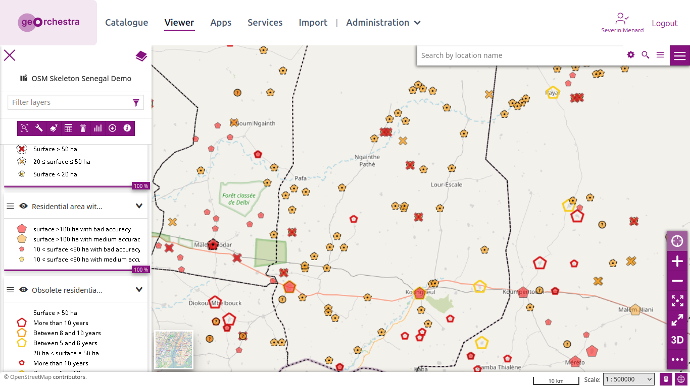
And zooming in on Koungheul:
Posted by SeverinGeo on 19 August 2026 in French (Français).
Last updated on 20 August 2026.
Suite au lancement de la méthodologie OSM Skeleton (voir ce billet, repris dans hebdoOSM 836), j’ai voulu l’illustrer avec un exemple, en résolvant les principaux signalements sur une zone du Sénégal, où la démo est actuellement déployée.
J’ai pensé au départ faire le département de Koungheul, mais vu l’ampleur de la tâche, je me suis finalement contenté de l’un de ses arrondissements, celui d’Ida Mouride. Les arrondissements constituent le troisième échelon administratif du Sénégal, après les régions et les départements, arrondissements.
La petite taille et le nombre limité de signalements Skeleton que contient cet arrondissement m’ont permis d’en venir à bout en une quinzaine d’occurrences de ma petite séance quotidienne de cartographie dans OSM.
La situation de départ au 31 juillet était celle-ci, à l’échelle du département entier :
Et en zoomant sur Koungheul :