Users' Diaries

Recent diary entries

Sto mappando la città in cui abito, Piombino. Nella scorsa settimana ho aggiunto quasi 7000 punti tra marciapiedi, strisce pedonali, panchine, cestini, pali della pubblica illuminazione, etc.

Perché lo faccio? Beh, innanzitutto perché Google, con le sue politiche sull’accesso ai dati che sono stati volutamente aggiunti dagli utenti e non da Google stessa, può andare a fare in culo. In secondo luogo, anche se Piombino è una città relativamente piccola, voglio che abbia le mappe più dettagliate e accessibili possibile. Infine, dato che utilizzo OSM nei miei progetti, volevo restituire qualcosa alla comunità, spargendo anche la voce che esiste e che è importante aggiungere la propria attività non solo su Google Maps, ma soprattutto su OSM.

In questa prima fase sto aggiungendo punti a destra e a sinistra e credo di aver già fatto un buon lavoro. Le fasi successive, però, sono ancora più importanti: l’aggiunta dei metadati agli elementi mappati e la ricostruzione degli edifici da zero (questi ultimi sono stati mappati 14 anni fa).

E niente, mandate a fare in culo Google, monopolista di dati che non sono suoi. Contribuite ai progetti open source, che permettono alle persone di costruire nuovi progetti basandosi su di essi.

Classifica: https://osmstats.neis-one.org/?item=countries&country=Italy

Location: Tolla, Piombino, Livorno, Toscana, 57025, Italia

愛知県尾張旭市内のバス停・バス路線のマッピングを進めています。 コミュニティバス「あさぴー号」の停留所について不明点が残っているため、1週間以内に現地調査に行きたいです。 また、瀬戸市内の商店街にある店舗についても、営業時間などの情報を調べてマッピングを進めていきたいと思います。

Location: 旭前町新田洞, 尾張旭市, 愛知県, 488-0866, 日本
Posted by Dokdo on 20 June 2026 in Korean (한국어).

최근에 현체로 경주월드 다녀왔거든요? 가기 한 이틀 전에 osm 드가서 경주월드 편집하는데 타카티스크?? (2022년에 운행 중단) 서라벌관람차?? (2022년 8월에 철거) 처음 들어본 게 많아서 당황했습니다. (심지어 타카티스크가 아니라 타가디스코임) 어쨌든 중요한 지물들을 편집했습니다. (미로탐험 없애고, 타임라이더 만들고 등등) 근데 잼민이인 저 혼자 하긴 너무 힘든거 같아서 제발 도와주시면 좋겠습니다 ㅠㅠ

(아니 줄바꿈 왜 안돼;;)

Location: 신평동, 보덕동, 경주시, 경상북도, 38117, 대한민국
Posted by Raquel Dezidério Souto on 19 June 2026 in English. Last updated on 23 June 2026.

Leia em Português

IVIDES DATA® held the third session of the Ciclo de Oficinas OSM 2026 (or 2026 OSM Workshop Series), focusing on QGIS plugins. Applied cases were presented on accessibility, urban tree cover, and the geolocation of buildings on areas subject to disasters


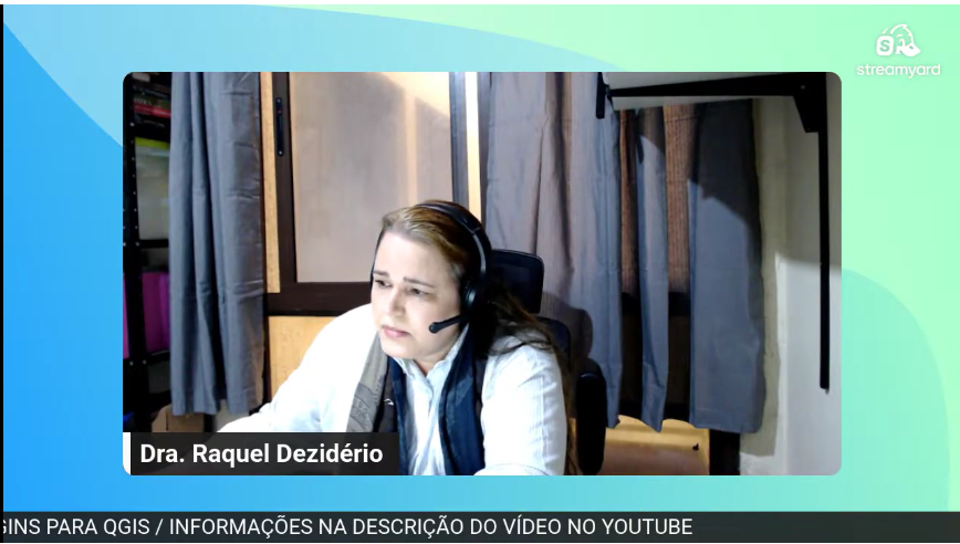
img1 Dr. Raquel Dezidério Souto leading Session 3 of the Ciclo de Oficinas OSM 2026. The files used in Workshop 3 can be found in the video description. Link


IVIDES DATA® successfully held the third live training session of the Ciclo de Oficinas OSM 2026 on June 12, during which the following were presented:


* View and download data on OSM.org
* Access to geoservices for loading OSM as a base layer - NextGIS QuickMapServices plugin
* Downloading data in QGIS (version 3.22 or later) – QuickOSM and OSM Downloader plugins
* Applied cases — accessibility, urban tree cover, and the geolocation of buildings on areas subject to disasters


See full entry

Location: Recreio dos Bandeirantes, Rio de Janeiro, Southeast Region, Brazil

Read in English

IVIDES DATA® realiza a terceira sessão do Ciclo de Oficinas OSM 2026, tratando de plugins para QGIS. Casos aplicados sobre acessibilidade, arborização urbana e localização de edificações em áreas de risco foram apresentados


img1 Dra. Raquel Dezidério Souto conduzindo a sessão 3 do Ciclo de Oficinas OSM 2026. Os arquivos utilizados na oficina 3 podem ser encontrados na descrição do vídeo. Link


A empresa IVIDES DATA® realizou com sucesso o terceiro treinamento ao vivo do Ciclo de Oficinas OpenStreetMap 2026, em 12 de junho, quando foram apresentados:


* Consulta e download dos dados em OSM.org
* Acesso a geosserviços para carregamento do OSM como base layer (camada base) - plugin NextGIS QuickMapServices
* Download dos dados no QGIS (versão 3.22 ou superior) – plugins QuickOSM e OSM Downloader
* Demonstração de casos aplicados - acessibilidade, arborização urbana, edificações localizadas em encostas


See full entry

Location: Recreio dos Bandeirantes, Rio de Janeiro, Região Sudeste, Brasil

This is a very simple idea: given a set of GPX traces for a hike you are planning to take, generate a file containing all the waypoints of interest within the area covered by the GPX traces. I create a buffer around the GPX traces and extract the area from OSM. I define a set of tags of interest. I use Ollama with Mistral Nemo to make sure that POIs make sense to visit while walking on foot, as places are sometimes mislabeled in OSM. Before saving the waypoints to a GPX file, I use Ollama again to generate waypoint descriptions and set labels for each waypoint. Feel free to try it out! The code is on GitHub.

Location: Khu phố 1, Saigon, Thủ Đức, Ho Chi Minh City, Vietnam
Posted by Jfact0ry on 19 June 2026 in English.

Mapping Sitka is pretty much my identity. I was upset when someone reverted my work because honestly I’ve been working every waking hour for a few months now. It was good though because I needed to step back and not take it too seriously. I’ve had some manic episodes late in life and they unlocked some anger I’m not familiar with. It was actually impressive how mad I got. Anyway, what are these diaries for if not a super personal post? Stay mappy people

Location: Sitka, Alaska, 99835, United States
Posted by pnorman on 18 June 2026 in English.

Earlier today I had to check an alarm on the servers. The alarm was for a non-issue, but I happened to notice a momentary delay to replication across multiple services and I wanted to investigate.

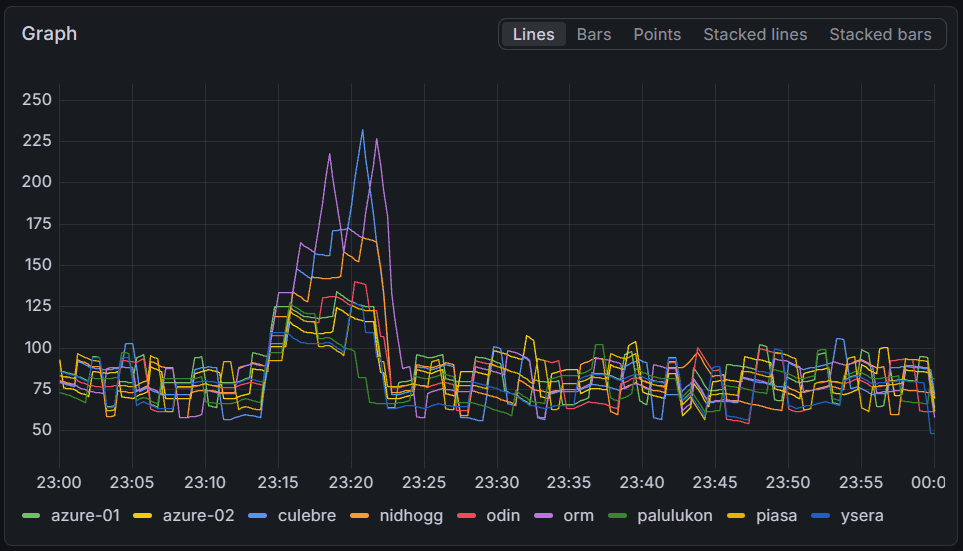
The rendering servers fell up to four minutes behind on some servers, with all servers falling at least a minute behind normal. Interestingly, there does not seem to be a correlation between the delay and the server capacity.

See full entry

Editora IVIDES has published the Swahili translation of the FPOSM booklet on the ODbL license


capa_sw


Download SW VERSION


The original work Tout savoir sur la license ODbL : la licence d’OpenStreetMap pour cartographier en commun was written in French in 2024 and updated in 2026 by the Fédération des Pros d’OSM, a French organization that brings together various companies and professionals working with open data, OpenStreetMap, and related software. The authors of the original booklet are: François Lacombe (Datactivist), Florian Lainez (Jungle Bus), Antoine Riche (Carto’Cité) and Christophe Biez (Latitude-Cartagène Cartographies).

The translation to Swahili was done by Hemed Lungo and Tatu Sultan Lungo, from Tanzania, and the booklet was edited by Raquel Dezidério Souto (Editora IVIDES).

The work is licensed under the Creative Commons Attribution-ShareAlike 2.0 France (CC BY-SA 2.0 FR). Text of the license


Download EN VERSION


Download VERSÃO PT


See full entry

Posted by AlexSpritze on 17 June 2026 in German (Deutsch).

Manchmal ist Wikimedia Commons eine gute Quelle für Objekte, die in OpenStreetMap fehlen, und manchmal ist es umgekehrt.

Aber wie lassen sich Informationen aus beiden schnell verbinden und am besten noch visualisieren?

Der naive Ansatz

💡 Daten per Abfrage aus Commons und OSM holen und in uMap anzeigen.

🏁 Als Beispiel möchte ich hier alle Ortseingangsschilder aus Sachsen-Anhalt visualisieren.

Naiv bedeutet hier natürlich auch, dass in Commons nicht alle Bilder ihre Standorte koodiert haben.

Wikimedia Commons mit PetScan abfragen

Wikimedia Commons bietet mit PetScan ein Tool an, das unter anderem auch nach KML exportiert. Ein Dateiformat, das nach uMap importiert werden kann. Folgende Parameter erzeugen in PetScan nach einem Klick auf “Do It” eine KML-Datei mit den entsprechenden Geo-Informationen:

Parameter Wert
Language commons
Project wikimedia
Depth 1
Categories Zeichen 310 in Saxony-Anhalt
Page Properties: Namespaces Commons, File
Output: Format KML
Output: Page Metadata Image, Coordinates, Default sort

Wichtig ist auch Depth auf größer 0 zu setzen, damit untergeordnete Kategorien miteinbezogen werden, so dass z.B. auch Ortseingangsschilder aus dem Saalekreis gefunden werden.

Der Inhalt der KML sieht dann ungefähr so aus:

<?xml version="1.0" encoding="UTF-8"?>
<kml xmlns="http://www.opengis.net/kml/2.2">
  <Document>
    <Placemark>
      <name>Hundeluft.jpg</name>
      <ExtendedData>
        <Data name="url">
          <value>https://commons.wikimedia.org/wiki/File%3AHundeluft%2Ejpg</value>
        </Data>
      </ExtendedData>
      <Point>
        <coordinates>12.34471667, 51.96599722, 0.</coordinates>
      </Point>
    </Placemark>
...

Falls die Datei im Browser angezeigt wird, muss man sie natürlich noch lokal speichern.

OSM Daten in uMap anzeigen

See full entry

Location: Cölbigk, Ilberstedt, Saale-Wipper, Salzlandkreis, Sachsen-Anhalt, 06408, Deutschland

I’ve been reflecting on the balance between mapping for ‘volume’ and mapping for ‘precision.’ While I understand the value of quick, large-area edits for global visibility, I find it a bit puzzling when polygons are generalized to the point of overlapping everything in sight—especially when high-resolution imagery is available.

I’ve noticed a trend where edit counts are sometimes treated as the ultimate metric of a mapper’s worth. I reckon we should be careful not to let the pursuit of ‘top contributor’ stats overshadow the primary goal of creating a detailed, accurate map for everyone. For me, a well-traced building or a correctly aligned path is worth far more than a high edit count achieved through imprecise mass-mapping. I’m always keen to learn the best practices, so if there’s a standard way to maintain precision while contributing efficiently, I’m all ears. Cheers.

(English version below)

Desafíos y adaptaciones en la organización de mapatones anticipatorios

En el equipo América Latina de HOT tenemos 4 años organizando mapatones preventivos nacionales en México, Perú, Ecuador y Colombia. Estos mapatones responden al 100% a una necesidad de los gobiernos locales y organizaciones dedicadas a la preparación y respuesta ante desastres. La organización de dichos mapatones entonces definen áreas específicas de máxima exposición a desastres en lugares donde llegan estos a ser conocidos porque son recurrentes. Nos lleva a concentrarnos en la categoría de los desastres climáticos. Esto también define en buena parte la temporada en la que deben suceder los mapatones para proceder datos de forma anticipada, no después de que haya pasado.

Otra característica que define la temporalidad de estos mapatones es cuando la población que más participa en las actividades se encuentra con disponibilidad. El conjunto de estos dos factores es lo que define (de manera imperfecta) los periodos de estos mapatones anticipatorios.

El factor climático y académico en la programación

See full entry

Location: Doctores, Roma, Ciudad de México, Cuauhtémoc, Ciudad de México, 06720, México

Mapadour, le groupe des contributeur⋅rices OpenStreetMap du Pays Basque et Sud Landes, a été particulièrement actif ces derniers mois.

Sa dernière réunion le 11 juin 2026 à Ustaritz est l’occasion de faire le point sur les dynamiques et les projets auxquels participe le groupe.

Ses membres interviennent localement mais aussi bien au-delà, en Nouvelle-Aquitaine jusqu’aux confins de la Finlande en passant par Paris et l’Italie sur toutes sortes de problématiques.

Panoramax

Les contributeur⋅rices locaux ont été très actifs puisqu’avec la Gopro d’OSM France et les autres matériels personnels pour alimenter la connaissance du territoire avec 228 003 photos et 2 747,66 km parcourus entre juin 2025 et mai 2026.

Ils ont également expérimenté plusieurs nouvelles fonctionnalités :

See full entry

State of the Map US 2026 Presented by OpenStreetMap US was this weekend in Madison, Wisconsin. As any good breakfast lover, I tried to seek out the best breakfast food in the area of Capitol Square. Here’s my thoughts:

Friday: Wonderstate Coffee (on OSM)

This is a very modern looking coffee shop (think crisp whites and light woods - if Apple had a coffee shop) with a great seating area outside overlooking the Capitol Square and is in a very nice spot to be shaded in the morning to enjoy your coffee or small food item. Only downside to sitting outside is you are very close to the road - but that’s to be expected in a downtown area.

I ordered a plain bagel and cream cheese, and an iced coffee with cream and sugar. Typically where I am this means drip coffee poured over ice, but the barista recommended an Americano… when in Rome I suppose. The coffee was delicious, and the bagel came out with more cream cheese than I think I have ever seen on a bagel (not complaining! Just surprising!)

Cost: $9.23 Rating: 7/10

Saturday: Marigold Kitchen (on OSM)

Such a cute spot! I was searching this day for a good omelette and this place seemed highly recommended. The feel was much more artsy coffeehouse vibe, plenty of lighting and a small outdoor seating area, but I ate inside. I was greeted and handed a menu at the door, ordered at the counter, and was recommended the pancakes as well as the omelette if I was hungry enough. Very friendly staff throughout even during what was clearly an elevated breakfast rush with the farmers market getting started just outside!

See full entry

Posted by Feuerwehr Talling on 14 June 2026 in German (Deutsch).

Hallo zusammen, nach meiner Ansicht wäre es sinnvoll ein Symbol für einen AED zu erstellen. Dann könnte man auch die Standorte von diesen Geräten in den Karten einpflegen. Die Abkürzung AED steht für Automatisierter Externer Defibrillator (oft auch als „Laien-Defi“ oder „Herzstarter“ bezeichnet). Es handelt sich um ein kleines, tragbares medizinisches Gerät, das bei einem plötzlichen Herzstillstand durch gezielte Stromstöße lebensgefährliche Herzrhythmusstörungen beenden kann. Diese Geräte sind wichtig für Ersthelfer die bereits eine Reanimation durchführen bevor der Rettungsdienst eintrifft. Ein Symbol wäre zum Beispiel wie in meinem Link vorgeschlagen eine gute Idee. https://shop.murer-feuerschutz.de/images/thumbs/0028576_241717.jpeg Ich würde mich freuen, wenn man dies umsetzen könnte. Mit freundlichen Grüßen D. Weinig

Location: Talling, Thalfang am Erbeskopf, Landkreis Bernkastel-Wittlich, Rheinland-Pfalz, Deutschland

Hi again!

In my previous diary entry I introduced myself and my GSoC project with Valhalla, and I mentioned we were still putting the finishing touches on the exact main goal. Now we have it! We’re focusing on area routing. This is basically means making the router cross open pedestrian areas (like squares) instead of walking around them and generating weird and inefficient routes. This diary entry is a deep dive into the research I’ve done while exploring the different options.

The problem with pedestrian areas

When you ask a router to go across a square, you would expect it to cross it like any person would. But a lot of routers don’t do that, they may send you around the perimeter or go along the streets surrounding the square. The problem here is that the open area has no “ways” inside of it to travel on.

Let’s see one example (using Valhalla) on Plaza Santo Domingo in Murcia (my hometown!):

See full entry