Posted by Provinsi Papua Pengunungan on 22 September 2024 in Indonesian (Bahasa Indonesia).
PEMERINTAH PROVINSI PAPUA PENGUNUNGAN 8 KABUPATEN
PEMERINTAH PROVINSI PAPUA PENGUNUNGAN 8 KABUPATEN
・この日記機能を使ってみて2か月半。公開の価値はともかく、自分の記録としては便利である。特に、後から編集できるのがありがたい。
・ゆかりの地(地方)を2か所チェックした。 登録時に正しかったが、今は変わっている情報が目に付く。 OSMの利用サイトでは、登録日を表示しているものがあった。 OSMを使うにはそういう配慮がいるかもしれない。 ポイント情報でいいので、もっと多くの人がこまめに登録、修正してくれる日が来ることを 期待している。
・地方でも、交通量が比較的多い幹線道路脇については、コンビニやガソリンスタンド、 人気の飲食店などはそこそこにマッピングされている。 しかし、今も正しい情報かどうかはチェックしていない。 また、Google Mapに比べれば桁違いに登録が少ない。
・医院などは都会でもGoogle Mapに登録されていないことは珍しくない。 自宅近くでは、歯医者はすぐにGoogle Mapに現れる。 これは歯医者は競争が激しく、自らが登録しているのであろう。 一般の医院はホームページを持つていることは多く、検索では現れるが、 当事者がGoogle Mapに登録することは少ないようである。 Google Mapには、悪い口コミも載るので、登録のメリットがないのであろうか。
Prima rotonda disegnata, sono abbastanza soddisfatto.
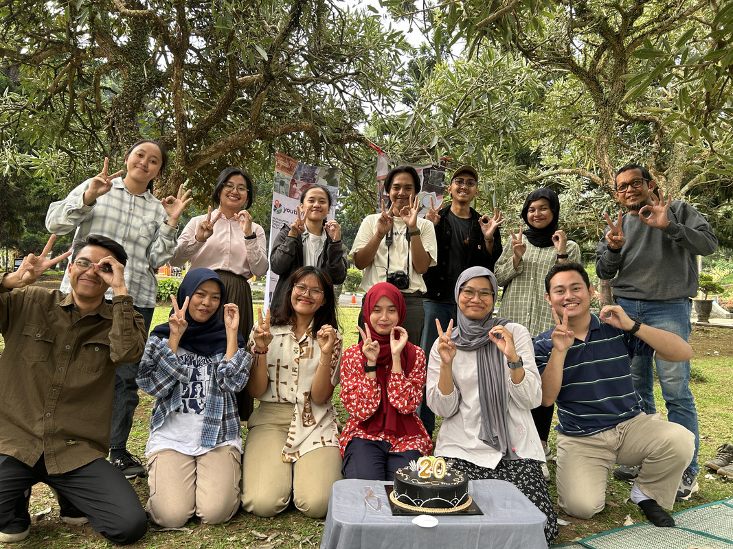
Tanggal 9 Agustus adalah hari ulang tahun OpenStreetMap. Kali ini para editor muda dari Youth Mapper Bandung ikut meramaikan ulang tahun OSM dengan acara potong kue dan bincang-bincang seputar pemetaan OpenStreetMap. Acara ini berlangsung hari Minggu, tanggal 11 Agustus yang lalu berlokasi di halaman depan Universitas Pendidikan Indonesia.
August 9th is the anniversary of OpenStreetMap. This time, the young editors from UPI Youth Mapper are celebrating the OSM Anniversary with a cake and blow the candle, continued by chit-chat around OpenStreetMap thingy. This event was held at the park in front of Universitas Pendidikan Indonesia.
Erstmal ein herzliches Dankeschön an alle, die OpenStreetMap möglich machen. In Kombination mit StreetComplete kann ich Menschen motivieren, ihre Anliegen zu verfolgen. In meinem Blog hier möchte ich auf Dauer Beispiele einstellen und mit anderen Aktiven vernetzen.
Dorothee Janssen, Netzwerk für Inklusion im Bistum Essen
A project I worked on, the Toronto Public Washroom Import recently finished up and I thought it would be interesting to do a quick lessons learned:
.value_counts(dropna=False) in pandas.On Saturday, September 14, 2024, Pakistan hosted its first-ever mapathon, a collaborative event aimed at contributing to the OpenStreetMap (OSM) community. The mapathon took place in Islamabad, Karachi, and online, bringing together a diverse group of participants.
In Islamabad, mappers gathered at the “Calmkaj” workspace, while in Karachi, they convened at the Habib University computer center. The day began with opening remarks by Mr. Shaji from COP, followed by an introduction to maps by Ms. Zainab Makti, a lecturer at Habib University.
I then provided an overview of OpenStreetMap, covering its purpose, community, global impact, and applications. Given the presence of many new mappers, I conducted a hands-on training session on editing and participating in Maproulette challenges. Training materials were also shared through WhatsApp and other social media groups prior to the event.
With over 60 participants in total (20 onsite in Islamabad, 30 in Karachi, and 16 online), the mapping session was a productive and engaging experience. I closely monitored edits and provided assistance to new mappers, ensuring the quality of contributions. To maintain enthusiasm and encourage participation, we announced prizes for the top Maproulette scorers.
Throughout the day, we enjoyed a lunch break provided by the COP team and participated in a fun quiz based on the training session. The event concluded with the distribution of prizes to the top three Maproulette performers.
The mapathon was a resounding success, attracting 30 new members to the Pakistani OSM community. Participants expressed interest in working on various mapping projects, including pharmacies and health centers in Peshawar and Islamabad, banks and their branch codes, water sources and union councils, and mangroves.
Mexico

Aghju aghjustatu assai macchia intornu à Patru è fureste statali à Pianedda. Hà aghjustatu ancu macchia à a gola d’Azzanido. Viva a Sardegna libera da l’Italia !
Procurad’e moderate, barones, sa tirannia, chi si no, pro vida mia torrades a pe’ in terra ! Declarada est già sa gherra contra de sa prepotenza: e incomintza’ sa passenzia in u so populu a mancare !

State of the Map 2024, Nairobi-Kenya: An Unforgettable Experience!
Wow! SotM 2024 in Nairobi, Kenya!!! I couldn’t contain my excitement when I received an email confirming that I’d been granted a full scholarship to attend the event. It was my first time attending the global State of the Map conference, and the thrill of meeting so many people from diverse backgrounds and regions was overwhelming. I even screamed when I read the news—why not? I was about to meet in person people I had only ever interacted with online, and the feeling was indescribable.
The first thing I did was reach out to my fellow OSMers, who I consider family, to confirm who else was attending. The joy from those who affirmed they’d be there was palpable. We kept in touch, discussing our preparations for the big day. Butterflies fluttered in our stomachs as excitement built. We knew exactly when everyone would arrive in Kenya.
I spent 11 nights backpacking in Glacier National Park this summer (on two separate trips), and noticed that existing mapping of the campsites is minimal. Each site generally consists of several tent sites, a food preparation area with bear-proof storage (a pole for hanging or a bear box), a toilet, and usually a fresh water supply. Usually there is a schematic map of the campsite posted, like this one shown below.
While I was there, I took a number of photos of camp site maps (I have not been able to find them online from the National Park Service), and did quick GPS surveys of a few sites with my Garmin watch.
I have made a first attempt at adding a full backcountry camp site map for Hole in the Wall Camp in this changeset. My approach was:
A few notes and limitations:
От перекрестка автозаправки вот до этого момента дорога в ужасном состоянии
incibey Halil inci
مزرعه کشاورزی پدر استخر آبیاری تحت فشار آبیاری نوین مصرف بهینه آب آبیاری با دستگاه های لینیر خطی و پ کشت باغ پسته هر سال ده هکتار اضاف به مجموعه باغات به علت کم آبی سفره های اب زیر زمینی و نیاز به اب کم درخت پسته #سیف آباد #دهستان پایین محمدآبادخره #مزرعه حاج سیف الله خراسانی و پسران #باغ پسته حاج سیف الله #جنب باغ پسته حاج آقا نظری رفسنجانی #مزرعه تأسیس سال 1364
Holy
Donner l’opportunité d’aller assister au STATE OF THE MAP ne pas donner à tous les mondes; c’est pourquoi ;je peux dire que je suis l’une des personnes le plus chanceuse d’avoir été sélectionné a la HOT OPEN Summet, la bourse pour assisté au StateoftheMap24. le STATE OF THE MAP était organiser pour la première fois en Afrique, au Kenya, Nairobi et c’était une opportunité en or pour moi de rencontré plusieurs passionner de la cartographie qui partage la même vision avec moi. Quitter la RDC; passant par l’Uganda jusqu’au Kenya, Nairobi… la route était trop longue mais ça valait la peine. Plusieurs leçons apprise, plusieurs méthodologies de la Cartographie, le StateoftheMap a toujours été un moment pas comme les autres car ça ressemble plusieurs personnes dont auparavant on avait l’habitude de parler en ligne ;

Durch eine Website über vier Schulstraßen in Dortmund [1] und mit der Frage im Forum [2] habe ich diese mit dem Tag
traffic_intervention=school_street
versehen.
Zusätzlich habe ich auf einer uMap [3] 17 weitere Schulstraßen eingetragen, die ich im Internet gefunden habe.
Wer ein Foto der Beschilderung hat, kann es mir gerne schicken (oder einen Link teilen). Ich werde es entsprechend ergänzen. Und falls jemand weitere Schulstraßen kennt, freue ich mich über Hinweise oder Kommentare!
[1] Schulstrassen auf dortmund.de
[2] Forum
[3] Karte
It is definitely good knowing how to use field tools to map on specific projects.
There comes experience 😊 regardless of previous teaching on how to use these tools like ODK, Vespucci, Mapsme and others; in the field you definitely have to use your own discretion to relate and adjust to what is given to maintain your nobility at work.
К нему не заростет народная тропа,
Вознесся выше он главою непокорной
Александрийского столпа.
Получилось вот так:
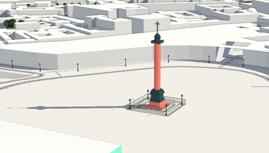
Так же на F4
Моделировать классицистические формы довольно просто, а вот с ангелом всё намного сложнее. Если у кого-то есть лицензионно-чистая модель ангела с Александровской колонны, например для 3д-принтера, милости прошу.
Нет, весь я не умру — душа в заветной лире
Мой прах переживет и тленья убежит —
И славен буду я, доколь в подлунном мире
Жив будет хоть один пиит.
Ну или хотя бы один картограф :)
P.S. Как бы так еще главный штаб переделать, чтобы он был похож на себя?
I became interested in the issue of localizing the map of Ukraine into English and decided to raise it in several forum discussions (first, second, third) to delve into the nuances and find optimal approaches to filling out the name:en tag for objects in Ukraine.
My goal was to understand how to correctly fill in the name:en tag and determine whether it should contain a translation or transliteration. While this may seem like a technical issue, it actually has deep cultural and historical roots, and the answer is not immediately obvious. However, through the discussion, I believe I found a solution and would like to share it in this diary.
First and foremost, it is important to understand the difference between endonyms and exonyms.
Endonym refers to the name of a geographical object in the language of the people who live in that area. For instance, for the residents of Ukraine, the name of the capital Kyiv is an endonym. Endonyms always reflect the authentic name used by the local population.
Exonym refers to the name for the same geographical object used by people or countries outside that area. Examples of Ukrainian exonyms include Viden for Wien, Niu-York for New York, and Florentsia for Firenze. The Spanish name for the city Lviv is Leópolis, and the German name is Lemberg. Historically, such names were formed quite chaotically, influenced by various linguistic traditions or political processes.


