 OpenStreetMap

Prima rotonda disegnata, sono abbastanza soddisfatto.
Users' Diaries
Recent diary entries
Posted by amtplskaart on 21 September 2024 in Indonesian (Bahasa Indonesia).
Last updated on 23 September 2024.

Acara Tiup Lilin
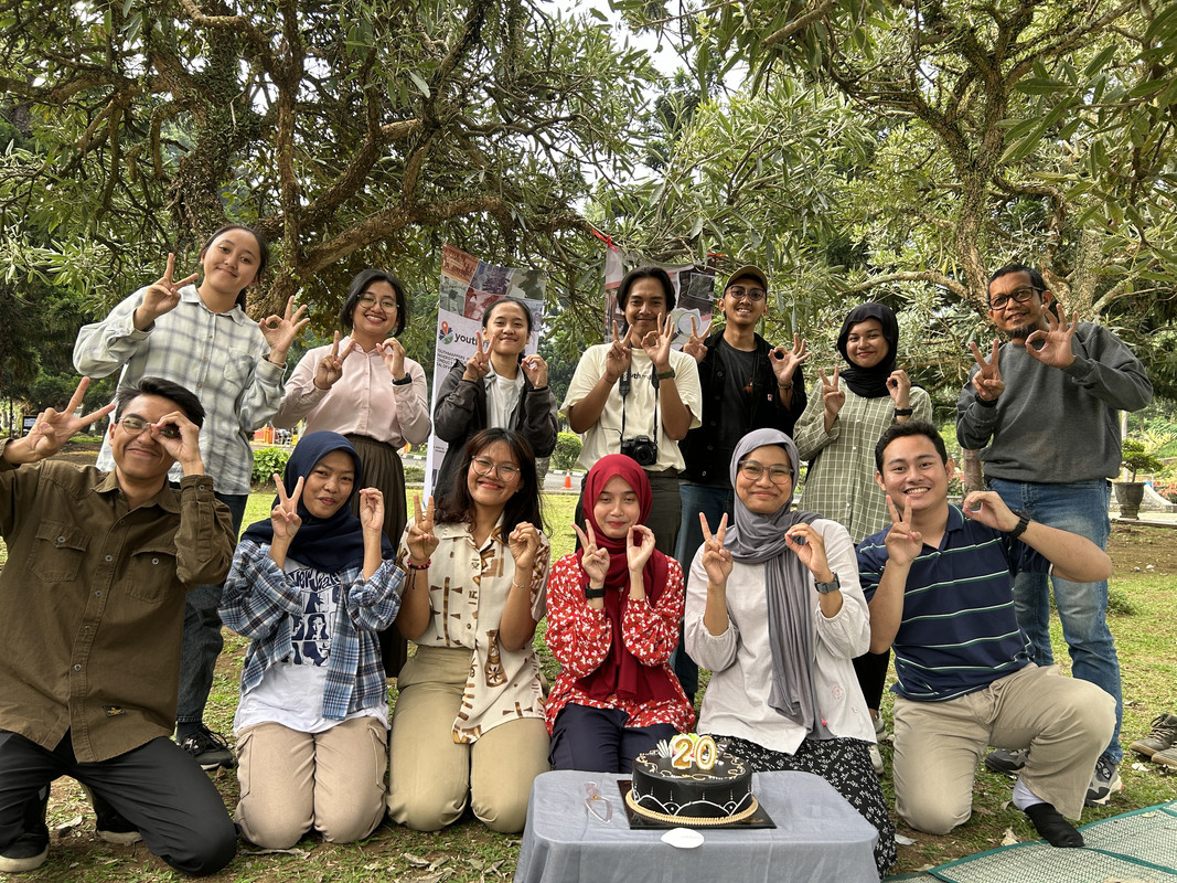
Tanggal 9 Agustus adalah hari ulang tahun OpenStreetMap. Kali ini para editor muda dari Youth Mapper Bandung ikut meramaikan ulang tahun OSM dengan acara potong kue dan bincang-bincang seputar pemetaan OpenStreetMap. Acara ini berlangsung hari Minggu, tanggal 11 Agustus yang lalu berlokasi di halaman depan Universitas Pendidikan Indonesia.
Blow the Candle
August 9th is the anniversary of OpenStreetMap. This time, the young editors from UPI Youth Mapper are celebrating the OSM Anniversary with a cake and blow the candle, continued by chit-chat around OpenStreetMap thingy. This event was held at the park in front of Universitas Pendidikan Indonesia.
Pelatihan Dasar ID Editor

Erstmal ein herzliches Dankeschön an alle, die OpenStreetMap möglich machen. In Kombination mit StreetComplete kann ich Menschen motivieren, ihre Anliegen zu verfolgen. In meinem Blog hier möchte ich auf Dauer Beispiele einstellen und mit anderen Aktiven vernetzen.
Dorothee Janssen, Netzwerk für Inklusion im Bistum Essen
Posted by tallcoleman on 21 September 2024 in English.

A project I worked on, the Toronto Public Washroom Import recently finished up and I thought it would be interesting to do a quick lessons learned:
Top three things that went well:
- Having help from other people makes things much easier — I am grateful to RockTeam for helping with the changesets and for Jarek_Piórkowski and a couple members of the Civic Tech Toronto community for their input on the import plan.
- Doing a couple “test” imports and recording an instruction video significantly improved the written import plan and instructions. It’s also very helpful to have mapped a couple of the relevant features via survey as well.
- For the script that converted the City data to OSM tags, setting and validating assumptions about the City data using Pandera helped give me a lot of confidence that the output wouldn’t be affected by upstream changes to the City data.
Top three things I would change if I did it again:
- Increased the time assumption for how long it would take to complete all the changesets. I had originally expected it would take two weeks at most, but it took closer to three (even with two people doing changesets).
- For the initial data profiling, I might try using e.g. Tableau public, since it would be a little faster and easier than e.g. using
.value_counts(dropna=False)in pandas. - Have the data transformation script estimate how many washrooms should be conflated vs. net new in each changeset - this would provide a simple comparable metric to ensure that the conflation plugin was configured correctly for each changeset.
Top three resources that were helpful:
Posted by Ezra Edwards on 20 September 2024 in English.

On Saturday, September 14, 2024, Pakistan hosted its first-ever mapathon, a collaborative event aimed at contributing to the OpenStreetMap (OSM) community. The mapathon took place in Islamabad, Karachi, and online, bringing together a diverse group of participants.
In Islamabad, mappers gathered at the “Calmkaj” workspace, while in Karachi, they convened at the Habib University computer center. The day began with opening remarks by Mr. Shaji from COP, followed by an introduction to maps by Ms. Zainab Makti, a lecturer at Habib University.
I then provided an overview of OpenStreetMap, covering its purpose, community, global impact, and applications. Given the presence of many new mappers, I conducted a hands-on training session on editing and participating in Maproulette challenges. Training materials were also shared through WhatsApp and other social media groups prior to the event.
With over 60 participants in total (20 onsite in Islamabad, 30 in Karachi, and 16 online), the mapping session was a productive and engaging experience. I closely monitored edits and provided assistance to new mappers, ensuring the quality of contributions. To maintain enthusiasm and encourage participation, we announced prizes for the top Maproulette scorers.
Throughout the day, we enjoyed a lunch break provided by the COP team and participated in a fun quiz based on the training session. The event concluded with the distribution of prizes to the top three Maproulette performers.
The mapathon was a resounding success, attracting 30 new members to the Pakistani OSM community. Participants expressed interest in working on various mapping projects, including pharmacies and health centers in Peshawar and Islamabad, banks and their branch codes, water sources and union councils, and mangroves.
Mexico
Posted by conifermapper on 20 September 2024 in Sardinian (Sardu).


Aghju aghjustatu assai macchia intornu à Patru è fureste statali à Pianedda. Hà aghjustatu ancu macchia à a gola d’Azzanido. Viva a Sardegna libera da l’Italia !
Procurad’e moderate, barones, sa tirannia, chi si no, pro vida mia torrades a pe’ in terra ! Declarada est già sa gherra contra de sa prepotenza: e incomintza’ sa passenzia in u so populu a mancare !

State of the Map 2024, Nairobi-Kenya: An Unforgettable Experience!
Wow! SotM 2024 in Nairobi, Kenya!!! I couldn’t contain my excitement when I received an email confirming that I’d been granted a full scholarship to attend the event. It was my first time attending the global State of the Map conference, and the thrill of meeting so many people from diverse backgrounds and regions was overwhelming. I even screamed when I read the news—why not? I was about to meet in person people I had only ever interacted with online, and the feeling was indescribable.
The first thing I did was reach out to my fellow OSMers, who I consider family, to confirm who else was attending. The joy from those who affirmed they’d be there was palpable. We kept in touch, discussing our preparations for the big day. Butterflies fluttered in our stomachs as excitement built. We knew exactly when everyone would arrive in Kenya.
Arrival in Nairobi
I spent 11 nights backpacking in Glacier National Park this summer (on two separate trips), and noticed that existing mapping of the campsites is minimal. Each site generally consists of several tent sites, a food preparation area with bear-proof storage (a pole for hanging or a bear box), a toilet, and usually a fresh water supply. Usually there is a schematic map of the campsite posted, like this one shown below.
While I was there, I took a number of photos of camp site maps (I have not been able to find them online from the National Park Service), and did quick GPS surveys of a few sites with my Garmin watch.
I have made a first attempt at adding a full backcountry camp site map for Hole in the Wall Camp in this changeset. My approach was:
- Place the camp itself at the main trail junction, usually where the camp map is posted, tagged as tourism=camp_site. This is the way camps are tagged in OSM now (locations are rather approximate).
- Map the paths between parts of the camp, tagged with highway=path
- Add each official tent site as a node tagged with tourism=camp_pitch
- Add the toilet with amenity=toilets. In the case of Hole in the Wall, tagged with toilets:disposal=chemical, but in most cases it will be toilets:disposal=pitlatrine.
- Tagged the food preparation area with amenity=bearproof_storage, bearproof_storage=hang. This one is not very standard, I followed an example from this forum post.
A few notes and limitations:
От перекрестка автозаправки вот до этого момента дорога в ужасном состоянии
.jpeg)
incibey Halil inci
Posted by 𝘑𝘢𝘧𝘢𝘳 ⇲ 𝘒𝘩𝘰𝘳𝘢𝘴𝘢𝘯𝘪 on 20 September 2024 in Persian (فارسی).
Last updated on 25 June 2026.
Zarrindasht Khorasani
Originality in the Root, Blessing in the Fruit
زریندشت خراسانی مجموعهای خانوادگی و ریشهدار در حوزه کشاورزی، باغداری و دامپروری است که بر پایه میراث نسلها، دانش فنی، مدیریت مستقیم خانواده و بهرهگیری از روشهای نوین کشاورزی شکل گرفته و توسعه یافته است.
این مجموعه با تکیه بر اصالت، تجربه و نگاه بلندمدت به تولید، در زمینه توسعه باغ پسته، کشت محصولات زراعی و استفاده از سیستمهای مکانیزه و بهروز آبیاری فعالیت میکند.
باغ پسته زریندشت که پایهگذاری آن از دهه ۱۳۷۰ آغاز شده، امروز پس از سالها صبر، مراقبت و تلاش، به یکی از ارزشمندترین بخشهای این مجموعه تبدیل شده است.
زریندشت خراسانی، روایتی از پیوند عمیق خاک، آب، آفتاب و همت نسلهایی است که باروری، ماندگاری و برکت را در دل این سرزمین معنا کردهاند.
Holy
Posted by Mariannamukulunga on 19 September 2024 in French (Français).
Last updated on 21 September 2024.

Donner l’opportunité d’aller assister au STATE OF THE MAP ne pas donner à tous les mondes; c’est pourquoi ;je peux dire que je suis l’une des personnes le plus chanceuse d’avoir été sélectionné a la HOT OPEN Summet, la bourse pour assisté au StateoftheMap24. le STATE OF THE MAP était organiser pour la première fois en Afrique, au Kenya, Nairobi et c’était une opportunité en or pour moi de rencontré plusieurs passionner de la cartographie qui partage la même vision avec moi. Quitter la RDC; passant par l’Uganda jusqu’au Kenya, Nairobi… la route était trop longue mais ça valait la peine. Plusieurs leçons apprise, plusieurs méthodologies de la Cartographie, le StateoftheMap a toujours été un moment pas comme les autres car ça ressemble plusieurs personnes dont auparavant on avait l’habitude de parler en ligne ;


Durch eine Website über vier Schulstraßen in Dortmund [1] und mit der Frage im Forum [2] habe ich diese mit dem Tag
traffic_intervention=school_street
versehen.
Zusätzlich habe ich auf einer uMap [3] 17 weitere Schulstraßen eingetragen, die ich im Internet gefunden habe.
Wer ein Foto der Beschilderung hat, kann es mir gerne schicken (oder einen Link teilen). Ich werde es entsprechend ergänzen. Und falls jemand weitere Schulstraßen kennt, freue ich mich über Hinweise oder Kommentare!
[1] Schulstrassen auf dortmund.de
[2] Forum
[3] Karte

It is definitely good knowing how to use field tools to map on specific projects.
There comes experience 😊 regardless of previous teaching on how to use these tools like ODK, Vespucci, Mapsme and others; in the field you definitely have to use your own discretion to relate and adjust to what is given to maintain your nobility at work.

К нему не заростет народная тропа,
Вознесся выше он главою непокорной
Александрийского столпа.
Получилось вот так:
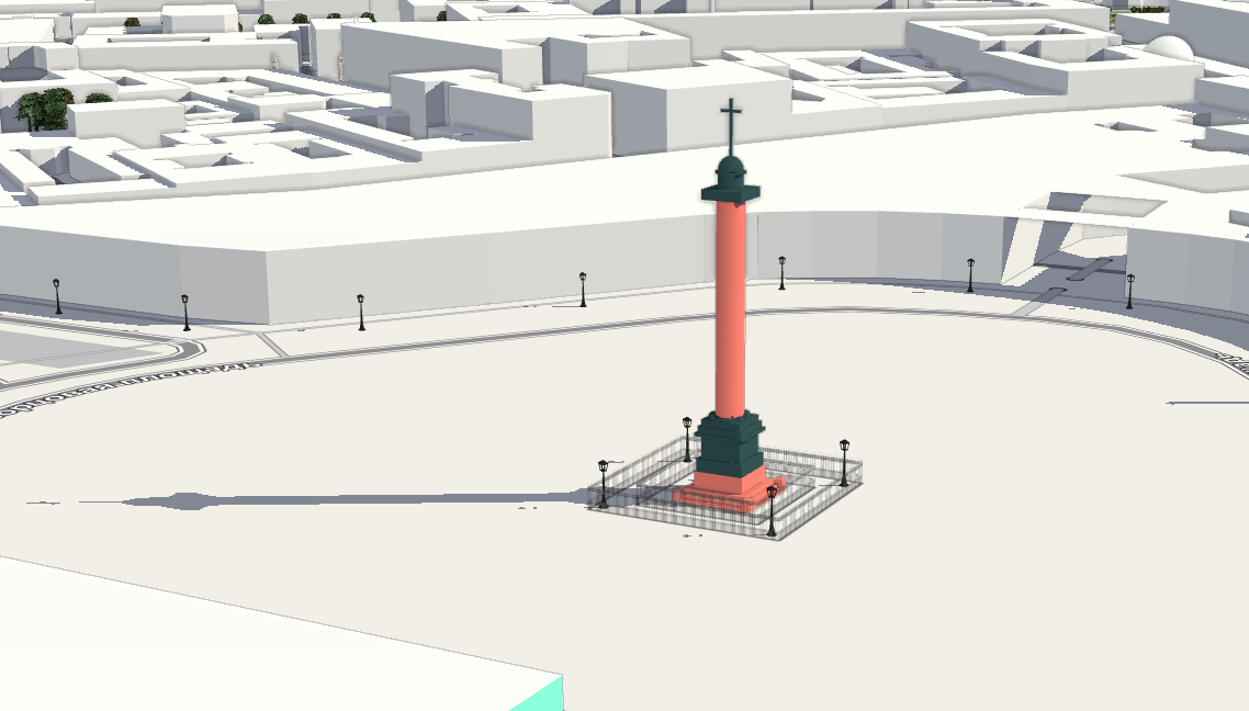
Так же на F4
Моделировать классицистические формы довольно просто, а вот с ангелом всё намного сложнее. Если у кого-то есть лицензионно-чистая модель ангела с Александровской колонны, например для 3д-принтера, милости прошу.
Нет, весь я не умру — душа в заветной лире
Мой прах переживет и тленья убежит —
И славен буду я, доколь в подлунном мире
Жив будет хоть один пиит.
Ну или хотя бы один картограф :)
P.S. Как бы так еще главный штаб переделать, чтобы он был похож на себя?

I became interested in the issue of localizing the map of Ukraine into English and decided to raise it in several forum discussions (first, second, third) to delve into the nuances and find optimal approaches to filling out the name:en tag for objects in Ukraine.
My goal was to understand how to correctly fill in the name:en tag and determine whether it should contain a translation or transliteration. While this may seem like a technical issue, it actually has deep cultural and historical roots, and the answer is not immediately obvious. However, through the discussion, I believe I found a solution and would like to share it in this diary.
Endonyms and exonyms: what are they?
First and foremost, it is important to understand the difference between endonyms and exonyms.
Endonym refers to the name of a geographical object in the language of the people who live in that area. For instance, for the residents of Ukraine, the name of the capital Kyiv is an endonym. Endonyms always reflect the authentic name used by the local population.
Exonym refers to the name for the same geographical object used by people or countries outside that area. Examples of Ukrainian exonyms include Viden for Wien, Niu-York for New York, and Florentsia for Firenze. The Spanish name for the city Lviv is Leópolis, and the German name is Lemberg. Historically, such names were formed quite chaotically, influenced by various linguistic traditions or political processes.

Last week we released Rapid v2.4, the most advanced web-based editor for OpenStreetMap. This release wraps up several months of work, includes numerous bugfixes, and a few notable features:
🈺 Improved Text Localization
Now Rapid can again be localized into different languages. The Rapid Editor project on Transifex allows anyone from the community to translate Rapid.
📷 Improved Handling of Street-level Imagery and Detections
We squashed a bunch of bugs and made many improvements to how Rapid handles street-level imagery, such as Mapillary. Now users can select a detected feature or traffic sign to learn more about it, and Rapid will highlight the imagery that shows that detection, both on the map and in the viewer. This will be especially useful for mapping pedestrian features, such as traffic signs, crosswalks, bike racks, and more.
👩💻 Use Rapid
👉 Bookmark Rapid and make it your editor of choice:
Posted by Sujan Adhikari on 17 September 2024 in English.

Introduction:
Over the past year, I have been working as a backend developer on the Field Mapping and Tasking Manager (FMTM) project for the Humanitarian OpenStreetMap Team (HOT). My role has involved system design, feature development, and bug fixing, all aimed at enhancing the efficiency and usability of field mapping for humanitarian purposes. One of my key contributions has been developing and refining the FMTM Splitter —an algorithm designed to streamline field mapping by dividing map Areas of Interest (AOI) into manageable tasks for mappers.
In this post, I will discuss the workings of the FMTM Splitter, the challenges we’ve overcome, and how OpenStreetMap (OSM) data plays a vital role in making this tool effective for humanitarian efforts.
The FMTM Splitter: Two Key Algorithms
The FMTM Splitter is crucial for breaking down large AOIs into smaller, manageable tasks for field mappers. The goal is to ensure that mappers can efficiently collect and update information without having to cross major obstacles like highways or rivers. This makes the mapping process not only faster but also safer and more convenient for field mappers.
We developed two main algorithms for splitting AOIs: