After some time away, I am back at validating and helping map buildings in Ireland. The Fingal project is sitting at 30% complete (mapped + validated).

The Map Paint Styles by Jonny really help with the validation process.
After some time away, I am back at validating and helping map buildings in Ireland. The Fingal project is sitting at 30% complete (mapped + validated).
The Map Paint Styles by Jonny really help with the validation process.
Mapping on OpenStreetMap allows many things, like 3D mapping.
Having played Cities: Skylines, I was always intrigued by this game, and the idea emerged: “It would be nice if for Pyongyang I could come up with something nice like Cities: Skylines”.
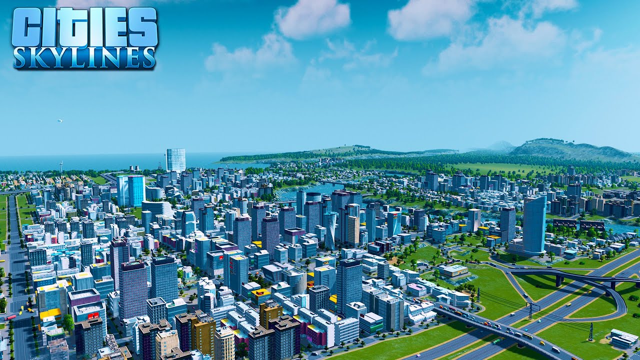
Well, the reality is that it’s a lot of work (and yes, as always!) and OSM wasn’t designed for 3D… but there are ways of getting close and having a lot of fun! So I explored this topic on the city that interests me, and you guessed it: it’s Pyongyang, see it on DemoF4map !
Today, I estimate that there’s a third of the city “in 3D”, as well as a good proportion of the monuments.
I decided to end my 2,687-day non-stop editing streak today (1st March 2024), because my mental and physical health has declined to a point where I need to rest more.
A changeset or more per day from Day 1 may have been a good challenge back in October 2016, but maintaining a high-stakes daily editing streak has become too much for me to handle.
I don’t know how long this break will last: it depends on what I need to catch up on other things.
The first paragraph was corrected from 2,686 days to 2,687 days, to reflect the final tally on the How did you contribute to OpenStreetMap? service by Pascal Neis.
I’ve put up a demo page showing my work on minutely updated vector tiles. This demo is using my work for the tiles and the Versatiles Colorful stylesheet.
With this year being the year of OpenStreetMap vector maps I’ve been working on making vector tile maps that update minutely. Most maps don’t need minutely updates and are fine with daily or, at most, weekly. Minutely updates on OpenStreetMap.org are a crucial part of the feedback cycle where mappers can see their edits right away and get inspired to map more often. Typically a mapper can make an edit and see their edit when reloading after 90-180 seconds, compared to the days or weeks of most OSM-based services, or the months or years of proprietary data sources.
Updating maps once a week can be done with a simple architecture that takes the OSM file for the planet and turns it into a single file containing all the tiles for the world. This can scale to daily updates, but not much faster. To do minutely updates we need to generate tiles one-by-one, since they change one-by-one. When combined with the caching requirements for osm.org, this is something no existing software solved.
For some time I’ve been working on Tilekiln, a small piece of software which leverages the existing vector tile generation of PostGIS, the standard geospatial database. Tilekiln is written specifically to meet the unique requirements of a default layer on osm.org. Recently, I’ve been working for the OSMF at setting up minutely updated vector tiles using the Shortbread schema. A schema is a set of definitions for what goes in the vector tiles, and Shortbread is a CC0 licensed schema that anyone can use and there are existing styles for.
لكننا مسافرين في زمن بعيد
لست جاهز لا يمكنني تذكرني
Cette semaine , je m’amuse sur ce mapathon parceque c’est toujours une partie de plaisir pour moi de cartographier et de contribuer.
Ce qui marque particulierement sur ce projet est complexité lié au calage de l’imagerie par rapport à l’existant cartographié. Avec Maxar n’etant pus disponible, le decalage est vraiment tres visible et facilement remarquable ici.
mais bon!!!!
na louce
I have tentatively completed the sidewalks in Ben Avon, as well as pedestrian crossings, and some fire hydrants. I have added surface materials to most, if not all of the sidewalks and ped crossings. Some of the pedestrian crossings may have had their lines repainted more recently than the available street-level imagery I have access to, so I will update them as necessary.
For now, I’ve held off tagging sidewalks and pedestrian crossings with smoothness and slope data, partly because of the difficulty of adding that manually, but also because I’m not quite sure how useful this data is given that few renderers seem to use this data. Even Wheelmap.org seems to only pull the data on individual buildings/businesses, rather than the condition of the pathways that lead between them. So unless I come across a compelling reason to go back and add this data, this aspect is on pause for me.
One of my next goals was to be adding private driveways and walkways to connect with sidewalks and streets, but I am second-guessing this now. While many are easily visible from a combination of aerial and street-level photography, there are also quite a few that are difficult to see under heavy tree cover.
I am going to investigate how to properly map stop signs and other traffic control devices, and perhaps add speed limits to roadways as I am able.
I also ran into some trouble when adding a bridge area and modifying another bridge area, along with the associated ways that pass over and under it… so I probably need to brush up on how best to modify those for future use.
There are also a couple of areas that probably should be modified to be more in line with existing conditions. For example, there are a few blocks east of Dickson Avenue, between Perrysville and Church that are not included in the adjacent Residential Area when they really should be.
El año ya está un tanto avanzado, pero nunca es tarde para hacerse unos propósitos de año con respecto a OpenStreetMap. Esto a manera de retomar la actividad de mapeo y aporte a OSM.
Los siguientes temas tomarán mi atención (por orden de importancia):
Revisión y completado de la delimitación de la ciudad de Santa Cruz y otras unidades administrativas (manchas urbanas, municipios) en el departamento de Santa Cruz, Bolivia. Estas delimitaciones, especialmente de la ciudad, ayudan para algunas aplicaciones que requieren establecer hasta donde comprende la ciudad.
Revisión, actualización y completado de infraestructura de salud pública (municipal, departamental, nacional) en la ciudad de Santa Cruz, Bolivia. A manera de aporte al interés público y como complemento a lo que hago en mi trabajo diario.
Revisión, actualización y completado de la cobertura de cajeros automáticos en la ciudad de Santa Cruz, Bolivia. Caso de estudio de compilación de datos con potencial de análisis espacial.
Actualización de mi zona (unidad vecinal 52) en la ciudad de Santa Cruz, Bolivia: caso de estudio de una zona con cobertura densa de datos.
Como verán, este año estará centrado en lo que me es más cercano geográficamente, que puedo visitar y verificar.
اننت ناگ
INDRZ is available at the WU https://campus.wu.ac.at Wirtschaftsuniversität Wien Welthandelsplatz 1, AD 1020 Wien
INDRZ indoor maps at the Technical University of Vienna (https://tuwien.ac.at/maps)
I’ve made a start at mapping the shops in Glastonbury - the result of which is that Glasto now has three quarters of all the places tagged with shop=esoteric in the UK.
Some of these could be shop=herbalist or shop=jewellery; others may be better tagged as shop=gift (although that implies most purchases are for other people, which I’m not sure is the case here). There are some that offer alternative medicine or services such as tarot readings. But many of them offer such a mix of items and services that “esoteric” seems the only proper description.
Малые Диковичи - имеются: названия улиц, номера и тип домов.
Малые Дворцы - имеются: названия улиц, номера и тип домов.
Сернички - имеются: названия улиц, номера и тип домов.
Кривое село - имеются: названия улиц, номера и тип домов.
Иванисовка - имеются: названия улиц, номера и тип домов.
Болгары - имеются: названия улиц, номера и тип домов, насосная станция, сеть ЛЭП. В том числе отрисовано садовое товарищество “Сосновка” (чуть севернее от Болгары по Н-232).
Просцы - имеются: названия улиц, номера и тип домов.
Конотоп - имеются: названия улиц, номера и тип домов.
Клин - имеются: названия улиц, номера и тип домов.
д. Городище - имеются: названия улиц, номера и тип домов, медицинское землепользование.
п. Городище - имеются: названия улиц, номера и тип домов, водные объекты (в т.ч. Святое озеро), инфраструктура железной дороги, промышленная зона, трубопроводная инфраструктура (газ), социальные объекты.
Староселье - имеются: названия улиц, номера и тип домов.
Состояние некоторых населённых пунктов от 27.02.2024 в Пинском районе:
Малый Холожин - имеются: названия улиц, номера и тип домов, местная подстанция (КТП-439). Упорядоченные сельхоз. угодья вокруг деревни.
Большой Холожин - имеются: названия улиц, номера и тип домов.
Лисятичи - имеются: названия улиц, номера и тип домов, подстанция ТП-1114, номера и тип домов. Исправлена геометрия водоёма и местной фермы.
Доброславка - имеются: названия улиц, номера и тип домов, кладбище и землепользование фермы.
Большая Вулька - имеются: названия улиц, номера и тип домов.
Понятичи - имеются: названия улиц, номера и тип домов.
Перекрестье - имеются: названия улиц, номера и тип домов.
I’ve been meaning to tag the pavement lights in and around Dublin for a little while now but just never got around to doing it. While walking (briefly) in town to catch the Dart, I added notes for a couple that I noticed. In hindsight, I should have tagged them while I was there, as a couple are tricky to find due to the shadow of the building.
Having said that, I managed to get a couple in the city centre as well as one in Blackrock Village. Big thanks to b-unicycling for the video that details how to tag them!
Overpass Turbo: Pavement Lights in Ireland
I came across a TikTok video which mentioned the old GPO milestone markers. They were used to help the postal service and the community figure out how far away they were from the city centre and the General Post Office.
b-unicycling helped map a lot of them down Malahide Road and towards Howth. There was one in Blackrock (Rock Road) that had been tagged a few years back but was missing the historic=milestone tag, which I added today. I will continue to look out for these as I’m walking around - I actually saw one in person that I had gone past a bunch and not stopped to think what it was.
Overpass Turbo: GPO Milestone Markers
C’é una via (sentiero) ciclabile fra Praja Ajeta Tortora (stazione) e Laino Borgo?
I recently got this comment on my Proposal on Forum. https://community.openstreetmap.org/t/rfc-feature-proposal-deprecating-demolished-railway-tags-cancelled-proposal/109757/2
This undoubtedly hurt my feelings. Since, well, I have been trying to make OSM better in tagging.
As a result, ‘'’I have paused proposal-making for this moment.’’’ Don’t know if this is temporary or permanent, but I have to. Users have undoubtedly hurt how me, as a mapper and pretty much a proposer of lots of proposals, try to improve OSM tagging.
Sorry, if user reads this, it hurt your feelings. I just need to make sure everyone knows.
Querido diario… El día de hoy actualice los nombre de calles del pueblo de Tlamanca, Patlanalan Quiliayo y Tepan de los rosales al igual que ubicaciones de paradas de autobuses para una mejor ubicación y entendimiento, espero estos cambios sean publicados en Google Maps y Maps de ÍOS. Estos cambios son a base de conocimiento propio adquirido por el pueblo y su gente.
Sin mas por decir me despido y espero ayudar con mi contribución. ATENTAMENTE Alex Shepherd Masón


