OpenStreetMap logo OpenStreetMap

Users' Diaries

Recent diary entries

Posted by Jiri Podhorecky on 30 January 2024 in Czech (Česky). Last updated on 29 February 2024.

Před lety (přesněji v srpnu 2019) jsem v Českém Krumlově začal jeden nevšední projekt.

Šlo o myšlenku založit ve městě komunitní zahradu, tedy malé relaxační místo, kde by si lidé mohli vypěstovat nějaké drobné výpěstky, ať už zeleninu, zahradní ovoce, nebo květiny. Ve městě žádná nebyla.

Věděl jsem, že to nebude snadné. Bylo k tomu potřeba několik důležitých věcí, které jsem neměl, ale plánoval je získat. A proto jsem k tomu několik let vynakládal úsilí.

Lógr

Začal jsem v kavárnách sbírat lógr jako základ pro bio hnojivo do zahrady. Zároveň jsem hledal, zda by v katastru města byla možnost najít vhodný pozemek. A také jsem se snažil záměr lidem vysvětlovat. Co dělám, proč to dělám a jak by to mohlo souviset i s nimi.

Přes 2,5 roku jsem chodil denně do kaváren v centru města. Pouze se skromnými prostředky, jako kbelíky a uzavíratelné nádoby, jsem byl schopný nasbírat přes 14 metrů krychlových kávového lógru. Tolik, či spíše ještě mnohem více dokáží vyprodukovat některé kavárny v centru města Český Krumlov!

Pro možnost komunitního sběru jsem adaptoval do češtiny aplikaci Karrot, která by se na to velmi hodila
See full entry

Location: Nový Vyšný, Nádražní Předměstí, Český Krumlov, okres Český Krumlov, Jihočeský kraj, Jihozápad, 381 01, Česko

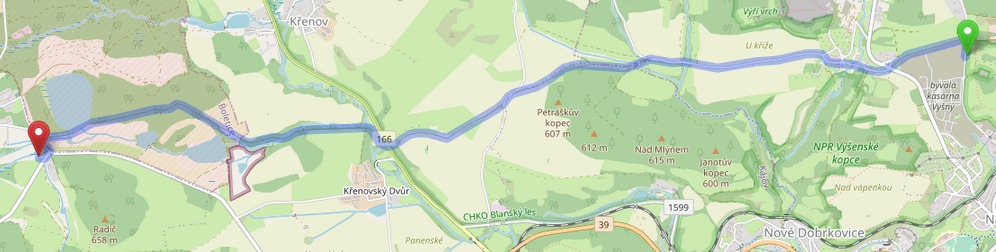
V blízkém okolí Českého Krumlova, od PP Cvičák přes Vyšný až do Boletic vede přes 7 km dlouhá panelová cesta. Chvíli jsem špekuloval, k čemu byla a pak jsem došel k jedinému logickému závěru.

Panelová cesta

Byla to vyhrazená cesta pro přesun vojáků a vojenské techniky mezi střelnicí, kasárnami Vyšný a Vojenským výcvikovým prostorem Boletice. Těžká technika by zničila běžné civilní cesty a tak byly lepší panely. Bohužel na kole se po cestě jede velmi špatně.

Ale zase pěkná krajina.

Location: Bláhův mlýn, Kladné, Kájov, okres Český Krumlov, Jihočeský kraj, Jihozápad, 382 21, Česko
Posted by arnalielsewhere on 30 January 2024 in English. Last updated on 31 January 2024.

I would like to congratulate and welcome OSM Belgium for being the newest (and returning) OSMF Local Chapter!

Thank you to Joost, Ben, Jonathan, Thierry and OSM Belgium community for your contributions in spreading the awareness, educating/training people and sharing the good news of OpenStreetMap!

Learn more about OSMF Local Chapters:

If you are interested in becoming a local chapter, and for questions and concerns, please comment in the community forum thread: Local Chapters: What To Know and How to Join or email local@osmfoundation.org.please email local[at]osmfoundation[dot]org :)

UPDATE AS OF 31 JAN

Hi community, I am greatly humbled by your overwhelming response! Thank you for your interest and volunteering to support our Membership Drive Campaign this Q1 of 2024!

I have scheduled a meetup this Saturday, 3 February at 11:00 UTC.

https://osmcal.org/event/2632/ https://osmcal.org/event/2632/

Please click ATTEND and answer the sign up form so we know which role you are willing to help 🙂

You can also input your email address so I can send the direct cal invite or you can click the ADD TO CALENDAR.

Important notes:

  • You need to be logged in to your OSM Account to be able to answer the sign up form 🙂
  • If you can’t make it, the session will be recorded and I will share it here as well as the meeting notes.

If you have any questions, please send it here! 🙂

Agenda: 1. Hello and Welcome 2. About OSMF and the Membership Drive 3. Timelines 4. Roles and tasking 5. Questions and comments 6. Any Other Business (AOB) 7. Actions and next steps

Meeting notes

See you!

ORIGINAL POST

Hi community,

wearing my OSMF Board hat and in our aim to grow and diversify OSMF membership, I am happy to initiate a Membership Drive/Campaign this first quarter of 2024!

Objectives:
  • Promote OSMF memberships (normal, associate, active contributor) with support from OSMF Communications WG
  • Provide general stats on membership make up (per region / per country)
  • Collaborate with regional/national community leaders especially in regions/countries where OSMF membership is low
With this, I am looking for volunteers and campaigners to be part of this initiative:
  • Mapmakers / comms volunteer/s who can help visualize membership make up and design Call to Action posters/pubmats
  • regional/national community leaders/promoters who can help us in this campaign
Are you interested?

Please comment on this diary or this thread in the community forum if you have time and are happy to help! :)

Thank you!

=Arnalie

last week the OSM Board and the DWG have given permission to anybody to change my 100% factual edits with out any intervention. This has already lead to the map displaying old outdated information. The changeset i’m bringing attention to osm.org/changeset/146818956 The Gawler Bypass which even has it’s own wikipedia article https://en.wikipedia.org/wiki/Gawler_Bypass was completed in 2010, its intended function was to divert all traffic wanting to go north of Gawler to go around the entire town. The section of Main North Road that goes through Gawler was officially downgraded to a secondary road plus it’s route number B19 was also removed. When this section was classed in OSM I suspect it was based on its class before the license change and its was kept as “primary” which was not wrong, it is a fact that it was a primary road at the time. https://imgur.com/ZrpOFr8 My edit clearly with supported information is correct to class it as secondary. I would like to ask The DWG how we move forward as a community and keeping the integrity of the information at the same time. OSM is a important project to me and I would like to find a way to work together here without slowly watching road by road the factual information fall apart. more relevant links posted below https://data.sa.gov.au/data/dataset/trailblazer-roads osm.org/changeset/12436982#map=15/-34.5780/138.7422 https://en.wikipedia.org/wiki/Main_North_Road#cite_note-8 https://www.dit.sa.gov.au/nsc/northern_expressway osm.org/#map=13/-34.6025/138.7299

previous diary entry osm.org/user/slice0/diary/403361

Posted by TrickyFoxy on 29 January 2024 in English.

TL;DR I wrote a little extension for Firefox for script developers to get an OAuth token in a couple clicks


OSM will soon remove support for Basic Auth and OAuth 1.0.

The proposal is to use OAuth 2.0, which has a much worse UX for novice developers than Basic Auth.

To show that OAuth 2.0 can be made more convenient even than Basic Auth I made a Firefox extension to automatically get an OAuth token:

demo


A bit of technical details and emotion:

See full entry

Bonjour, je suis Emmanuel Youma ZOUBINNABA de la communauté OpenStreetMap au Togo. Titulaire d’une licence en géographie, mes domaines d’intérêt incluent la programmation (Python, Javascript), le traitement et l’analyse de données, la cartographie, la télédétection, ainsi que la gestion et l’administration de données spatiales.

Forte de ma passion pour la cartographie et des compétences acquises dans le traitement de données géographiques, j’ai eu le privilège marquant de participer à la 4e édition du State of the Map Africa qui s’est tenue à Yaoundé, au Cameroun, à l’United Hotel de Mbakomo, à la fin de novembre et au début de décembre 2023. Cette expérience a été l’occasion parfaite de mettre en pratique mes connaissances et de contribuer activement à la communauté OpenStreetMap dans un contexte africain stimulant.

A propos du State of the Map Africa

Le State of the Map Africa (SotM Africa) est une conférence régionale biennale célébrant la culture de la cartographie ouverte, des données ouvertes, du système d’information géographique (SIG) et de son impact à travers toute l’Afrique. La conférence de cette année à Yaoundé au Cameroun, intervient après celles organisées respectivement en Ouganda en 2017, en Côte d’Ivoire en 2019 et au Kenya (en ligne en raison de la pandémie à coronavirus) en 2021. Organisée sous le thème « La cartographie ouverte comme outil de développement local en Afrique», cette conférence qui a lieu en fin d’année 2023 à Yaoundé, la toute première du genre au lendemain de la pandémie à coronavirus, a connu au total 255 participants en présentiel provenant de 23 pays à travers l’Afrique. Fort de cette constatation, cette conférence s’est révélée être, trois jours durant, un véritable terrain de grandes retrouvailles, d’excellentes rencontres, d’échanges constructifs, d’apprentissages inédits, de partages instructifs et surtout, d’expériences inoubliables qui sauront perdurer dans le temps.

See full entry

Location: Mbakomo, Obala, Lekié, Région du Centre, Cameroun
Posted by PhoebeSM on 28 January 2024 in English.

This weekend I started mapping the east-of-Gillham part of 43rd St in KC. I went from Gillham to just past 71 on Saturday, and further east to Indiana on Sunday.

Pedestrian-safety observation: The crossings on either side of Gillham Park are The Worst. You can go way up or down and find a crosswalk with a light, or you can take your chances running across both-way car traffic and then both-way bike traffic without much visibility. For this entire stretch of road (and most of my outdoor activities around KC) I wear bright dae-glo jackets. I call it protective coloring.

There wasn’t much to map in this area as it was mostly homes. I crossed the bridge over Highway 71 and found a few benches and a bookcase that was locked. I mapped these, but I do not think they are being maintained anymore. There was a defunct church nearby that I think they were part of. I took photos of the various tags on the bridge and the view looking down on the highway while crossing - cool and fun for me, but not necessarily mapping-related. I also photographed a few tags painted on walls, but nothing quite rose to the level of a mural.

See full entry

Location: Ivanhoe Southwest, Kansas City, Jackson County, Missouri, 64110, United States
Posted by Thelone1986 on 28 January 2024 in French (Français).

Une semaine plus intéressante avec l’arrivée tant attendue des images satellite du SPW pour 2023!

La semaine qui vient de passer peut se diviser en deux pour moi sur OSM : l’avant avec surtout du micromapping et de la correction de bâtiments, puis l’après avec un retour sur le boulevard urbain de Seraing qui avait vraiment besoin de ces nouvelles images pour enfin être mis à jour comme il faut.

J’avais mentionné la semaine dernière que je pensais faire seulement deux vidéos, mais de nouveau ce changement a précipité les choses et il y en a donc bel et bien trois. Ce côté avant/après est d’autant plus évident avec ce que j’ai enregistré.

Améliorons Seraing (sur OpenStreetMap) - Épisode 27 (Bassins et pylônes) - Version live de ce changeset où je corrige/ajoute un certain nombre de bassins d’orage et de pylônes électriques. L’idée était de montrer une session OSM plus “normale” pour moi, ou quand je n’ai pas un but précis en tout cas

Améliorons Seraing (sur OpenStreetMap) - Épisode 28 (Lucky 777 et Ortho 2023) - Version live de ce changeset où je découvre les nouvelles images et redessine le boulevard urbain comme il se doit. Un peu à l’improviste parce que je voulais faire autre chose en fait, cet autre chose étant…

Améliorons Seraing (sur OpenStreetMap) - Épisode 29 (Les bus du boulevard urbain) - Version live de ce changeset où je corrige le tracé de certaines lignes de bus sur ce même boulevard urbain et ajoute l’antenne d’une autre. Cette vidéo aura été frustrante parce qu’il m’a fallu QUATRE tentatives pour avoir le résultat final… que j’ai dû également couper parce qu’un énième problème est arrivé pendant l’enregistrement et la vidéo serait deux fois plus longue sans cette coupure

See full entry

Location: 50.583, 5.503

На англофоруме намекнули, что шестиугольная сетка нашей генерализированной карты наводит на мысли о компьютерной игре.

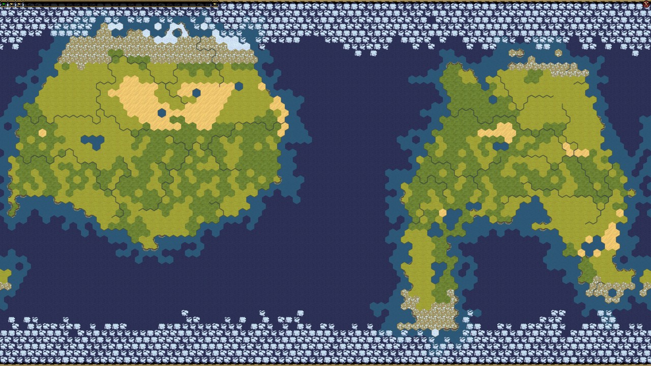
Я уже подумал, не сделать ли мне карту земли для шестой цивилизации, тем более, что карта в цивилизациии тоже основана на шестиугольной сетке, и формат открыт, так что можно было бы забацать простой скрипт.

random civ 6 map (Для наглядности, случайная карта из игры Civ6)

Карта Земли для цивилизации исключительно на основе данных осм – это было бы прикольно.

Географическая модель в Civ6 крайне примитивна, есть всего 5 типов местности, которые являются скорее типами почвы/климата:

  • SNOW (вечная мерзлота)
  • TUNDRA
  • GRASSLAND (более плодородная почва)
  • PLAIN (немного менее плодородная почва)
  • DESERT

есть 3 типа «особенностей»:

  • FOREST (Лес)
  • JUNGLE (Тропический лес, джунгли)
  • WETLAND (Болота)

(особенности они потому что их можно свести, или наоборот, насадить, а с почвой/климатом ты особенно ничего сделать не можешь )

и три типа рельефа:

See full entry

Brazil

Humanitarian Open Street Team’s Community Working Group’s Skillshare Session

The Community Working Group of Humanitarian Open Street Team (HOT) organized a Skillshare Session on January 19, 2024, at 12 UTC. This informative session featured Brazil Singh, the President of YouthMappers at Eastern University, as the speaker. The focus of the session was on imparting excellent skills related to WordPress website creation.

Session Details

  • Date and Time: January 19, 2024, at 12 UTC

  • Session Speaker: Brazil Singh, President of YouthMappers at Eastern University

  • Topic: WordPress Website Creation

  • Session Host: Eka Diweti

Speaker’s Expertise

Brazil Singh, the President of YouthMappers at Eastern University, shared his excellent skills in WordPress website creation. His expertise added valuable insights to the session, providing participants with practical knowledge in this essential field.

See full entry

Open Mapping Guru Fellowship: Navigating the Path to Excellence

Unveiling a New Chapter: Open Mapping Hub Asia Pacific

The journey to mastery in the field of open mapping has taken a significant turn for the better as I proudly announce my achievement of the Open Mapping Guru Fellowship conferred by the esteemed Open Mapping Hub Asia Pacific. Brazil

Location: West Dhanmondi, Dhanmondi, West Dhanmondi, Dhaka, Dhaka Metropolitan, Dhaka District, Dhaka Division, 1205, Bangladesh

Довгі роки колишній Барський район був білою плямою. Тепер її більше немає. абсолютно повсюди - тепер розписані поля, річки, ліси. Розмальована вся територія колишнього району (включно з селом Маньківці, які втекли в Северинівську громаду), а також інші території поза межами району і області (мої правки доходять аж до Деражні).

Цей процент 100% вважається таким, що не враховує об’єкти в населених пунктах. тепер можна приступати і до об’єктів в селах і в місті, а також до сусідніх районів.

Location: Мирне, Барська міська громада, Жмеринський район, Вінницька область, 23007, Україна
Posted by jlevente on 26 January 2024 in English. Last updated on 3 February 2024.

mapper | scientist | human

TL;DR I am deeply involved in different aspects of OSM. I am running for the OSM US board to extend my contributions beyond data creation, community organization and research.

About me

I am Levente, originally from Hungary, now living in sunny South Florida for about a decade. I came across OpenStreetMap in the early 2010s and instantly became fascinated by it. I actually decided to become a scientist because of it, and much of my research career is dedicated to understanding different aspects of the OSM project, data, and its community. Now I am running for a seat on the OSM US Board to continue my long standing commitment to the project in a different role.

During the day I am a Research Assistant Professor and currently I also serve as the Assistant Director of GIScience at Florida International University. I also teach Environmental GIS there. At night, I usually sleep. Prior to FIU, I spent a few years at the University of Florida (where I earned my PhD in Geomatics) and also held short-term visiting appointments at the Carinthia University of Applied Sciences in Villach, Austria, and at the Joint Research Centre in Ispra, Italy. In industry, I spent a few wonderful years at Mapillary (see e.g. here and here) and was also a full-stack GIS Developer at some point. I am an OsGeo Charter Member since 2023. While I am originally trained as a geographer, my background is more on the computational and data intensive side of the discipline and ventures into computer science and data science.

My involvement in OSM

I recognize that contributions are not limited to data creation. Below is a short summary of the different ways I have been involved in OSM over the last 10+ years.

As a contributor

See full entry

Location: Torch of Friendship, Miami, Miami-Dade County, Florida, 33131, United States

https://imgur.com/a/qNROb4E

When a mapping service chooses to pay for the rights for the street data and navigation they turn to the government, the state government hand over the map of their roads and classifications of the roads. The government of South Australia has given this information to the OpenStreetMap project for free all that needed to be done is for someone to translate the data onto the map. I was that person, and it has done nothing except for russle peoples jimmys all the way to the OSM board. The classification of roads goes way beyond a single dictionary meaning and has lots of different considerations such as traffic volume, width of the road, whether there are hazards such as railway crossings that the roads are engineered to avoid, speed, intersections etc. Thankfully the people who plan and engineer the roads take all of this into consideration and classify roads accordingly to what the intention of the road actually is. As far as OSM is concerned none of this matters and “what someone thinks it is from the ground” is far far more important and accurate. I 100% get that when this project started not a single government anywhere in the world gave this information over to the project and OSM needed to come up with some meaning and right and wrong way to classify roads. So the project decided on “Use highway=secondary to tag highways which are not part of major routes, but nevertheless form a link in the national route network. Secondary highways are generally specified by country road classification bylaws”. Which is fine and people were happy with that… but it leaves out a situation where. what if a government somewhere comes along and says “heres what our roads are feel free to use this” well what you see in the above screenshot happens, OSM does not allow for Real factual official government data to be allowed and I think this needs to change.

Bonjour chers passionnés de la cartographie libre ou collaborative ! Je suis Jimerveille THIERRY-NGOUAMA, contributeur OpenStreetMap basé en République du Congo et passionné de technologies géospatiales avec un intérêt particulier pour les systèmes d’informations géographiques, la télédétection, les bases de données spatiales, la programmation spatiale (R, Python & SQL) et les technologies de drones. C’est dans ce cadre que j’ai eu l’honneur de prendre part dernièrement au State of the Map Africa 2023 qui s’est tenu du 30 novembre au 02 décembre 2023 à Yaoundé au Cameroun. Conscient que les expériences ne sont agréables que lorsqu’elles sont partagées, j’ai le plaisir de me prêter à ce devoir pour vous faire part de mon expérience à ce grand rendez-vous de la cartographie libre et collaborative en Afrique.

A propos du State of the Map Africa

See full entry

Location: Zoatoupsi, Mbankomo, Méfou-et-Akono, Région du Centre, Cameroun