Users' Diaries

Recent diary entries

Posted by alexkemp on 7 July 2022 in English. Last updated on 8 July 2022.

I tried to launch JOSM for the first time in a little while & got the error:

failed to execute josm-latest no such file or directory

It had worked fine the last time I used it & had been continuously updated every since.

Searching for the Fix

An internet search did not reveal anyone reporting the same error, but did point me towards the GitHub site (more on that later, with the eventual fix at bottom of this diary post). Searching the computer did not help much, but it did reveal the .desktop menu file:

$ locate josm-latest
/etc/default/josm-latest
/usr/bin/josm-latest
/usr/share/applications/org.openstreetmap.josm-latest.desktop
/usr/share/josm-latest/josm-latest.jar

My local .desktop menu file is identical to the GitHub-code latest .desktop file. I tried running the exec-line in that file from a console (I work under Devuan, which is a Linux distribution):

$ josm-latest %U
bash: /usr/bin/josm-latest: /usr/bin/bash: bad interpreter: No such file or directory

Here is the reason why:

$ file /etc/default/josm-latest
/etc/default/josm-latest: ASCII text
$ cat /etc/default/josm-latest
# Options to pass to java when starting JOSM.
# Uncomment the JAVA_OPTS lines to enable their use by /usr/bin/josm-latest

# Increase usable memory
#JAVA_OPTS="${JAVA_OPTS} -Xmx2048m"

# Enable OpenGL pipeline (2D graphic accelerators)
#JAVA_OPTS="${JAVA_OPTS} -Dsun.java2d.opengl=True"
$ file /usr/bin/josm-latest
/usr/bin/josm-latest: Bourne-Again shell script, ASCII text executable
$ head -1 /usr/bin/josm-latest
#!/usr/bin/bash
$ la /usr/bin/bash
ls: cannot access '/usr/bin/bash': No such file or directory
$ which bash
/bin/bash

(translation): Neither josm-latest provided within the latest JOSM is fit for purpose:

See full entry

Wikidata is a free knowledge base for linked open data designed to support Wikipedia and its sister projects, such as Wikivoyage. It contains over 97 million entries structured as a “Labeled Property Graph,” which is more powerful than RDF-based graphs. Like OpenStreetMap (OSM), Wikidata (WD) is an open crowdsourcing project with a large and active community.

Since 2014, OSM can be linked to WD through its tags. Currently, there are about 5.5 million such Wikidata tags with steadily growing popularity. These links can be used to create interesting products, for example a map with castles enriched with factual data from WD. However, the quality of these manually captured links in OSM is as yet unknown and untested. One must also note that the preferred way from WD to OSM - the other way around - is to use only coordinates (WD property P625) - i.e., no WD properties such as P402 are to be used because this covers only OSM relationships.

Now, two computer science students, Jari Elmer and Timon Erhart, from the University of Applied Sciences of Eastern Switzerland (OST), with the help of Sascha Brawer - a young software engineer in “un-retirement” and Wikipedian - have developed an application called “osm wikidata quality checker”. The goal was to check the existing links from OSM to WD. The errors found - for example invalid WD entries in OSM - are also sent to osmose with a suggested correction. Osmose is a quality assurance tool for detecting problems in OSM data. The goal of the application was to become an integral part of OSM’s quality assurance ecosystem. It handles the large amounts of data in the two databases (about 1.5 TB each).

See full entry

Location: Rapperswil, Rapperswil-Jona, Wahlkreis See-Gaster, St. Gallen, 8640, Switzerland

Date - 07/06/22
Time Spent - 0.75 hrs Activity:
1. Trying to decide focus of next steps. Pedestrian footpaths or Lane mapping accuracy?
2. Tried to evaluate if small improvements to pedestrian footpaths can make it easier for kids/parents to walk to school?
Notes:
Used geojson.io to create a map_potentialwalkway.geojson trace to see where a footpath trace can be drawn. More to come about this exercise.

Location: Columbus, Sharon, Franklin County, Ohio, United States
Posted by Harry Wood on 6 July 2022 in English. Last updated on 7 July 2022.

Next week we’re having an OSMLondon pub meet-up for the first time in a while. Or at least I am. People don’t seem to like setting themselves as “attending” on osmcal.org, but I don’t think I’ll be alone in the pub. Looking forward to it anyway!

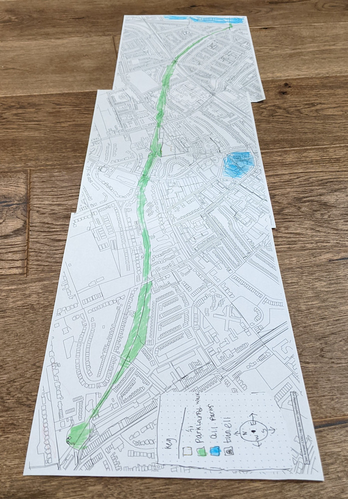
Today I wanted to print out a map of “Parkland Walk”, a local nature trail (and former railway). This was a project for/with my 6 year old son, which I spent a bit longer on than I should have today. In his class they’re doing various activities related to Parkland Walk. I thought it would be fun to give him a big map in style which he could colour in.

parkland walk map printout

See full entry

Location: Crouch End, London Borough of Haringey, Greater London, England, N8 9SU, United Kingdom
Posted by b-unicycling on 6 July 2022 in English. Last updated on 12 July 2022.

I’m preparing a video tutorial on thatched buildings - it’s dead simple, but it’s an interesting topic, I thought. So I was doing a bit of research trying to learn something about local thatching traditions and came across a 1994 survey by - it turns out - a thatcher. I only came across one volume which is basically a photo album of 106 thatched buildings in Co. Kilkenny with handwritten captions given the location. Location being in most cases the townland. But because it is handwritten and because this is Ireland, I have not been able to identify all the townlands.

What I’m doing now is trying to find the townland and trying to identify the building. Most times, if there are other buildings in the picture, it is possible to spot them in the townland by comparing the arrangement of buildings. Luckily, most buildings in Co. Kilkenny are mapped thanks to our #osmIRL_buildings project. And luckily, those are mostly old buildings, so I don’t have to worry about them being built since 2019. The National Index of Architectural Heritage is somewhat helpful in that they have indexed some of those buildings, but not all. They have a map where you can find a blue dot for those marking the spot. However, they are not always correct. They also have pictures of those buildings (sometimes also the wrong ones) which I can compare to that survey/ photo album. Sometimes, rarely, because those are very rural areas, I have mapillary to work with.

If they are not too far away and accessible for a non-driver like me, I’ll go and check them out in situ, take mapillary and a photo or two for Wikimedia. #OpenData, baby!

You can kind of see on Esri World Imagery (Clarity) Beta, whether it is thatched or a slate roof, because the thatched roofs have smoother corners and the colour is a bit different.

See full entry

Location: Knocktopher Manor, Knocktopher, The Municipal District of Callan — Thomastown, County Kilkenny, Leinster, Ireland
Posted by villasv on 6 July 2022 in English.

I have an endgame in mind, which is having a complete walkability study on a bunch of major cities in the world, which competes in quality with walkscore.com but it’s fully open data.

That’s too grand for me to accomplish in a year of less-than-part-time effort. So I’ve decided to scope it down to a single city I care about, which is Vancouver. How hard can it be to analyze walkability in a single city? Well, pretty damn hard actually.

The very first thing I’d like to consider analyzing walkability is proximity to amenities like cafés, markets and pharmacies. Turns out OSM seems to have pretty good coverage on shops in Vancouver already, but for me to be very confident on my analysis the study stars with an evaluation of data coverage.

If I’m going to compare OSM with an official source, say Vancouver’s Storefront Inventory, whatever the coverage might be… I might as well import what’s missing? I think I owe OSM this much, and it will be nice to say that the whole data used in the walkability study is from OSM instead of from multiple sources.

The thing is, my past experience with data imports is limited to a single one I made for Wikidata of Higher Education Institutions in Brazil, and it took a whole month to finish it. I had more tooling available (OpenRefine is very integrated with Wikidata), more time available (5 years ago I had more energy) and the data was much more straightforward (no mapping involved, just categorization)…

Considering all that, I’d estimate it would take me about 3 months to import the whole thing following proper procedures. So I’ve decided to scope it down once again, to a subset of the data that I can reasonably scan through manually. I’ll start with coffee shops / cafés only. That I think should bring the estimate back down to a single month or so. Hopefully.

Date - 07/05/2022
Time Spent - 1.5hrs
Changeset - #123254900
Activities:
1. Focused on improving junction and road definition at Bethel Road & Pickforde Dr.
2. Split Bethel Road and Pickforde Dr. by adding nodes.
3. Added lane information for Bethel Road and Pickforde Dr. going into and out of intersection.
4. Reviewed turn assignments at junction. They look okay.
Notes:
It was difficult to understand the correct approach to mapping a junction. The OSM Wiki documentation can benefit from additional examples and best practices.

Location: 40.082, -83.067

In my last diary entry I wrote about putting the requested note ids into url. I said that it’s likely not going to be a problem because ids are stored in the url part that’s not sent over HTTP therefore it doesn’t matter how long is this part, how many ids it contains. That was said about a typical output of neis-one.org note feeds for countries that contain updates dating back up to a week. For a busy country that’s usually a few hundred notes. Concatenated with single-character separators they result in a few thousand character string appended to a url.

Feeds are not the only way to get note ids from neis-one.org. In fact you may no even want to get notes from the feeds because of their one week age limit. There are regular html pages for each country too, one for all notes, another for open notes. They likely contain more notes than the feeds do. The open notes pages, which are of interest to someone who wants to resolve notes in a given country, can have up to ten thousand notes. I added options to open those with note-viewer, along with arbitrary html files. The last two options in the neis-one.org Get … notes for this country dropdown of the XML tab set up the selector (cells in second columns of tables from neis-one.org webpages) and open the webpage that you have to save to a file and then open that file with note-viewer. Unlike the xml feeds, even Firefox won’t start the download automatically.

See full entry

Создал трек межну смотровыми площадками 57.93657, 55.88472 Смотровая площадка 1 Смотровая площадка #4730463780 57.93652, 55.88628 Смотровая площадка 2 Смотровая площадка #4730463783

Location: Мураши, Нижние Муллы, Пермский муниципальный округ, Пермский край, Приволжский федеральный округ, 614521, Россия

Seit 2021 bin ich in der Region unterwegs und trage Daten zu Bildstöcken, Wegkreuzen, Marterl zusammen. Und die werd ich versuchen hier festzuhalten. Da openstreetmap vom Funktionsumfang weniger hergibt wie die Fülle an Info zu den christlichen Flurdenkmälern, beschränke ich mich auf die Positionsdaten und die Unterscheidung Bildstock - Wegkreuz. Marterl am Straßenrand, welche auf Unglücke hinweisen, werde ich im ersten Schritt nicht anführen. Ebenso muss ich erst herausfinden, inwieweit ich Bildbäume in der Karte festhalten kann.

On peut classer les chemins de randonnée par niveau de difficulté (et d’équipement requis) en utilisant l’attribut “sac_scale” :

  • sac_scale=hiking (randonnée)
  • sac_scale=mountain_hiking (randonnée en montagne)
  • sac_scale=demanding_mountain_hiking (randonnée en montagne exigeante)
  • sac_scale=alpine_hiking (randonnée alpine)
  • sac_scale=demanding_alpine_hiking (randonnée alpine exigeante)
  • sac_scale=difficult_alpine_hiking (randonnée alpine difficile)

Voir le détail sur : Key:sac_scale

On peut retrouver tous les attributs relatifs aux chemins de rando sur le wiki Randonnée pédestre

Posted by alessandrocarmeli on 2 July 2022 in Italian (Italiano). Last updated on 17 July 2022.

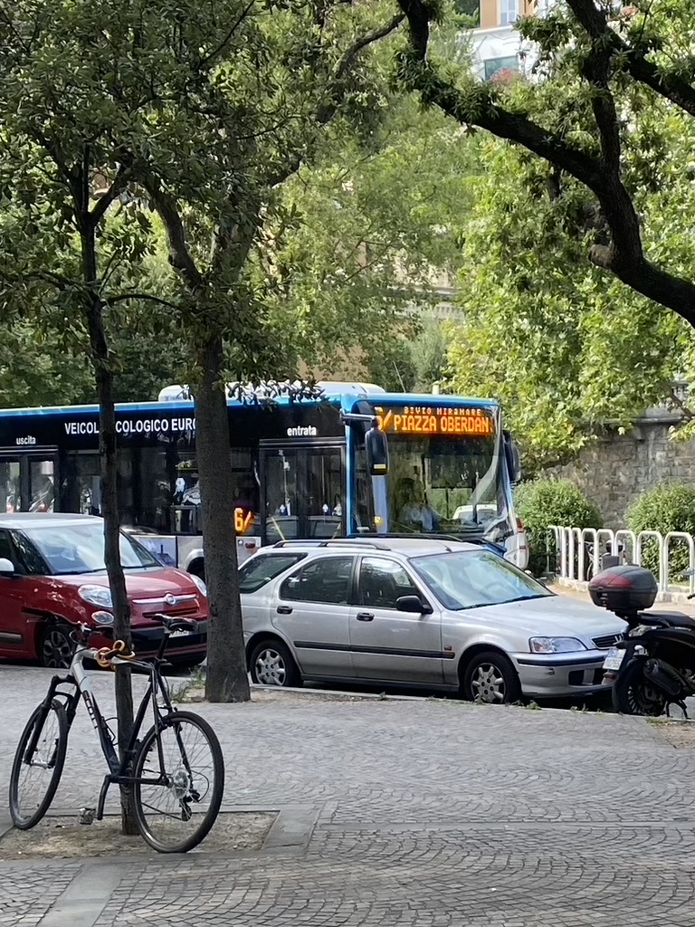
Con il 1 luglio 2022 la Trieste Trasporti (con supervisione di TPL FVG) ha deciso di rinumerare le corse della linea 6 tra Piazza Guglielmo Oberdan ed il Bivio di Miramare co il numero barrato per non creare confusione. Ho proceduto alla rinumerazione aggiungendo la /, è creato anche il nuovo route_master.

Ricordo che le corse deviate per Porto Vecchio, a sostituzione delle linee 80 (soppressa) ed 81 (sospesa nel servizio estivo) non hanno diversa numerazione, tantomeno capolinea rispetto alla 6 “normale”; allego foto scattata da me il 01/07/2022.

6/ in transito presso la pineta di Barcola (foto mia) Con il primo luglio entra anche nuovamente in servizio la linea 90 tra Alto Adriatico e Lazzaretto, a rinforzo della linea 7.

Location: Roiano-Gretta-Barcola-Cologna-Scorcola, Trieste, Friuli-Venezia Giulia, Italia

Notes of countries

One of possible uses of note-viewer is browsing notes in some area. You can do this using the BBox dialog that lets you get notes in a rectangular area. This is similar to how the note layer on the OSM website work and how the editors like JOSM load notes. And it similarly won’t work if the area is too large or not rectangular. So if you want to get notes in a country, you won’t be able to get them easily. But you may know that there are services that show notes for a given country, like the one by Pascal Neis. There you can select a country and get a list of notes filtered by their status.

That’s how you can get a list of notes for a country. But what if you want to see notes on a map? The list doesn’t contain note coordinates so it can’t be done directly. The situation is similar to looking at a list of user’s notes on the OSM website, something that note-viewer was originally written to take care of. Can it handle country lists now? Actually it can handle any list with note ids. In addition to showing webpages with note lists, Pascal Neis’ site also has Atom feeds. It’s going to be easier for us to get note ids from these feeds. And no, unfortunately, they still don’t contain coordinates.

Any list in our case is an XML file, and note-viewer handling it means that it’s possible to come up with selectors for XML elements that contain note ids. If ids are inside some attributes, the names of the attributes also need to be specified. Click on the XML tab in note-viewer and look below the instructions for neis-one.org to see the inputs for selectors and attributes. You won’t have to use them if you only want to get note lists from neis-one.org, just follow the instructions above.

Getting the list

See full entry

Zona de estacionamiento reservada para personas con movilidad reducida Zona de estacionamiento reservada para personas con movilidad reducida junto al castillo de Gibralfaro. Fuente: trabajo propio (CC BY-SA 4.0) disponible en Wikimedia Commons.

Se están incorporando al mapa de OpenStreetMap las plazas de estacionamiento reservadas para personas con movilidad reducida disponibles en el municipio de Málaga. Se trata de una importación realizada a partir de datos abiertos del Ayuntamiento de Málaga.

See full entry

Location: Centro Histórico, Centro, Málaga, Málaga-Costa del Sol, Málaga, Andalucía, España