Users' Diaries

Recent diary entries

Posted by rblldnk on 19 October 2024 in Indonesian (Bahasa Indonesia). Last updated on 22 October 2024.

Setiap tahunnya Ikatan Bujang Gadis Unsri mengadakan pemilihan Bujang Gadis Universitas Sriwijaya. Kegiatan ini diikuti oleh 60 peserta pra semi finalis Bujang Gadis Universitas Sriwijaya 2024. Tahun ini diselenggarakan di Aula D3 Fakultas Ekonomi Universitas Sriwijaya dan berlangsung selama bulan oktober. Peserta yang hadir berasal dari berbagai macam jurusan seperti ekonomi, keguruan, teknik, hubungan internasional dan lain sebagainya.

Pada kegiatan kali ini saya berkesempatan mengisi salah satu materi yaitu memperkenalkan definisi pemetaan, aplikasi pemetaan dan kegunaan dari peta. Tidak hanya untuk mahasiswa yang berasal dari disiplin ilmu geografi/pemetaan, namun sebagai pengetahuan dasar bagi setiap orang. Peta sangat bermanfaat dalam kehidupan sehari-hari, peta dapat membantu kita menuju lokasi yang diinginkan. Peta memuat informasi seperti titik koordinat, menentukan arah, jarak, luas, bentuk permukaan bumi, fenomena alam, serta pola sebaran bahkan informasi untuk penelitian.

Aplikasi pemetaan yang paling familiar digunakan dalam kegiatan sehari-hari adalah Google Map. Google Map biasa kita gunakan untuk mengetahui lokasi dan arah dari suatu tempat. Selain itu, kita bisa menggunakan ArcGIS, QGIS atau Openstreetmap (OSM) untuk memproses informasi dalam peta. Aplikasi pemetaan dapat diakses secara gratis dan berbayar. Bagi mahasiswa, OSM memiliki berbagai keuntungan karena gratis, tidak rumit bagi pemula, dan open source.

See full entry

Location: -2.985, 104.732

Welcome to the latest OpenStreetMap-NG development update! Since last time, we’ve made significant progress towards reaching feature parity and have also implemented some great, exclusive new features. There’s also an updated roadmap with more detailed public release progress.

🔖 You can read other development diaries here:
osm.org/user/NorthCrab/diary/

⭐ This project is open-source — join us today:
https://github.com/openstreetmap-ng/openstreetmap-ng

🛈 This initiative is not affiliated with the OpenStreetMap Foundation.


📹 Video Summary

I’ve prepared a video summary, where I recap the recent progress and show it off directly on the development website. It’s an alternative and richer version of this diary post. The recording contains chapter information if you’re interested in just some parts of this diary. There’s also a video-exclusive feature highlight :-)

⬇ Click below to play ⬇

Video thumbnail

or click here: https://peertube.monicz.dev/w/qWPQ8tNQK5VrGENPvpqnR1


OAuth2 Reimagined

See full entry

Aplicativos para ser usado em Rotas, Gravação de Trilhas e Mapeamento de objetos no Openstreetmap com o Celular.

Qual desses APP´S você já usou ou ainda usa???

Aplicativo OsmAnd https://osmand.net/

Aplicativo Maps.me https://maps.me/

Aplicativo Organic Maps https://organicmaps.app/pt/

Aplicativo StreetComplete https://streetcomplete.app/

https://umbraosm.com.br/2024/10/18/aplicativos-para-rota-e-mapeamento-no-openstreetmap/

See full entry

Location: -8.064, -34.896
Posted by TheFighter137 on 17 October 2024 in English. Last updated on 18 October 2024.

Here is my first diary entry. A few days ago, I gave myself the following challenge : every day, I will map one city in my department (Seine-Maritime, 76, France), going to the next letter in the alphabet for the next day, and so on. I will mainly map adresses (thanks to the Pifomap tool) ; precise roads’ paths and buildings’ positions ; and create driveways. There are 709 cities in total to map, but some will be easier to map than others for sure. The previous cities were Allouville-Bellefosse, Bacqueville-en-Caux and Cailleville.

Today, I worked on Dampierre-en-Bray. This rural municipality apparently is a relay for cyclists. There is the regional n°527 bus line operated by NOMAD Cars that passes nearby. Lots of single-family homes, as usual in my countryside.

Links to today’s changesets :

  1. First
  2. Second
Location: Les Bouleaux, Le Long Perrier, Dampierre-en-Bray, Dieppe, Seine-Maritime, Normandy, Metropolitan France, 76220, France

Le samedi 16 octobre 2024, l’Orange Digital Center Kinshasa a accueilli avec succès un atelier d’initiation à OpenStreetMap (OSM) et à la cartographie participative. L’événement, accessible en présentiel et en ligne, a rassemblé des passionnés de cartographie, des citoyens curieux et des développeurs désireux d’apprendre à contribuer à la création d’une carte collaborative du quartier.

L’atelier a débuté par une présentation approfondie d’OpenStreetMap, un projet collaboratif visant à créer une carte libre et gratuite du monde. Les participants ont découvert les avantages d’OSM et son impact sur les communautés locales, notamment pour l’aide humanitaire, le développement urbain et la planification de l’aménagement du territoire.

L’accent a ensuite été mis sur la cartographie participative, une approche citoyenne qui permet à chacun de contribuer à la mise à jour et à l’amélioration des données cartographiques. L’atelier a proposé une démonstration pratique de l’utilisation d’outils en ligne tels que le site web d’OSM et l’application mobile Streetcomplete, iD Editor. Les participants ont appris à identifier et corriger des erreurs sur la carte, à ajouter de nouveaux éléments et à enrichir les informations disponibles.

Des résultats concrets et un engouement palpable

L’atelier a suscité un engouement important. Les participants, enthousiastes et motivés, ont activement contribué à la cartographie de leur quartier. De nombreux points d’intérêt ont été ajoutés, quelques routes corrigées et des informations mises à jour. Cet engagement témoigne de l’importance de la participation citoyenne dans la création d’une carte fiable et précise pour tous.

L’atelier a également permis de créer un réseau de cartographes amateurs et professionnels, prêts à collaborer pour enrichir la carte d’OSM de Kinshasa. Les participants ont exprimé leur volonté de continuer à contribuer à ce projet collaboratif et de partager leurs connaissances avec d’autres personnes intéressées.

See full entry

Location: Ngunda Lokombe, Lingwala, Kinshasa, République démocratique du Congo

Once again i have the pleasure to announce that we, the OpenStreetMap Carto maintainers, have prepared a new release of the OpenStreetMap Carto stylesheet (the default stylesheet on the OSM website). Once changes are deployed on openstreetmap.org it will take a couple of days before all tiles show the new rendering.

Here are some details on the visible changes this release brings to the style.

Adding rendering of shop=hearing_aids with a dedicated symbol

shop=hearing_aids is now rendered with a dedicated symbol rather than just a generic dot. The tag has shown a steady increase in use over the years and is used consistently in many parts of the world now with a total of nearly 10k uses.

shop=hearing_aids

https://github.com/gravitystorm/openstreetmap-carto/pull/4909

Thanks to contributor sommerbe for implementing this and working on a suitable symbol.

Restoring rendering of name labels for natural=reef

See full entry

Posted by b-unicycling on 17 October 2024 in English.

I came across an article with a map in our local newspaper yesterday via a Facebook post, and at once, I thought “Oh, this map looks very much based on OSM”. This map had been published by the local County Council and had no attribution (to any map provider). So before sending a strongly worded email (because it’s not the first time they used OSM data without attribution), I played a game of spot the difference comparing the published map with OSM and the Táilte Éireann (government agency) data. Here are just four things I found: map of Kilkenny

Their map data is from before July 8th 2023 which is when I changed the name of a road according to new signage, but they still have the old name on their map.

I think it’s very interesting that the local government continues to choose OSM over the government provided data (not sure whether it’s a financial issue or a data quality issue), but it would be very decent of them if they attributed correctly.

See full entry

There doesn’t appear to be a resource available to aid in mapping The Mississippi Schools for the Deaf and the Blind, making it that much more important to map.

This diary entry serves mainly to help center my mapping efforts to the most important uses I can.

Location: Woodland Hills, Jackson, Hinds County, Mississippi, 39216, United States

One of my current focuses is the University of Mississippi Medical Center. To my surprise, much of the campus was not mapped - specifically buildings and parking garages. I get it - it looks a daunting task and it is.

Resource

Thankfully the University shares a campus map which has helped greatly. I’m still in the process of mapping the buildings, roads, footways, grass, trees, and flower beds.

Purpose

Obviously mapping a medical campus aids those who need to navigate their way around the various buildings and facilities in an easy and efficient manner. Hopefully this allows those that come after me to:

  1. Build on this information, contributing more than I can.
  2. Add ways to utilize this data for helping others (apps, guides, maps, etc.).
Location: Woodland Hills, Jackson, Hinds County, Mississippi, 39216, United States

Edital de Convocação para Eleger os novos Membros e o novo endereço fiscal.

Foi publicado hoje no site da #UMBRAOSM o edital para convocação de novos membros e a mudança do endereço fiscal atual para o novo endereço.

Edital de Convocação para Eleger os novos Membros e o novo endereço fiscal.

site da umbraosm

UMBRAOSM

Location: Ilha do Leite, Recife, Pernambuco, Região Nordeste, Brasil
Como corresponder as variáveis do CNEFE 2022 com as etiquetas do OSM?

O Instituto Brasileiro de Geografia e Estatística publicou a versão atualizada do Cadastro Nacional de Endereços para Fins Estatísticos (CNEFE 2022) e esta é uma proposta para correspondência entre as variáveis CNEFE 2022 e as etiquetas do OpenStreetMap.

Por Raquel Dezidério Souto (IVIDES.org e GeoCart-UFRJ)

O IBGE, orgão máximo da cartografia nacional brasileira, realizou o Censo Demográfico do Brasil 2022 e um dos produtos é a atualização dos dados do Cadastro Nacional de Endereços para fins Estatísticos (CNEFE 2022), que serve de referência para todas as pesquisas realizadas pelo orgão. Neste cadastro, estão integrados dados de regiões urbanas e rurais do país, mas o seu conjunto ainda apresenta inconsistências, que podem ser sanadas pelo mapeamento colaborativo.

Nessa via, o OpenStreetMap, a maior plataforma on-line de mapeamento colaborativo da atualidade, provê a estrutura necessária para a coleta e disseminação dos dados geoespaciais de logradouros, independentemente de sistema operacional ou equipamento do usuário.

Para realizar a importação dos dados do CNEFE 2022 para o OSM, uma das etapas de pré-processamento corresponde à compatibilização semântica entre as variáveis do CNEFE e as etiquetas do OSM.  Esta é uma proposta de correspondência entre as variáveis CNEFE 2022 e as etiquetas do OpenStreetMap (v. 5, 26 de dezembro de 2024).

Download - https://zenodo.org/records/14558995

Ver o quadro on-line

Página dos resultados - CNEFE 2022/IBGE

Planilha original - CNEFE 2022/IBGE


IVIDES.org® é uma marca registrada.

IVIDES DATA é uma empresa de pequeno porte, sediada no Rio de Janeiro, de consultoria em tecnologia da informação.

GeoCart - Laboratório de Cartografia da Universidade Federal do Rio de Janeiro (Brasil).


See full entry

You know what can really mess up carefully laid plans? What can even lead to a dangerous situation? When you get to the crossing of the South Fork Trinity River Trail and the East Fork South Fork Trinity River, a waterway that very much is still a river, and that bridge that someone has assured you they know is there is not there. There’s not even the evidence of once having footings for a bridge.

Apparently the mapper knew based on Bing aerial photography. Through thick trees. I can make guesses about how that crossing goes, too. At least when I guess wrong, I know it was a guess and might have made contingency plans around it.

Fortunately in the early days of Autumn, that ford I was LIED to about is just 4m of knee high wading without much current. That river comes out of some mountains that collect snow. It isn’t always so low.

The thing is, if it is important, it HAS to be correct. Your guess isn’t good enough. If it isn’t important, it can be left until someone who knows feels like doing it. There’s no renderer having trouble deciding how to render this crossing. It’s quite common that they aren’t specified.

I’ve been coming across a lot of guesses lately. I know they are guesses because they are wrong.

I was looking over an area I’d been working on when something started feeling wrong. It took me a couple minutes to notice that one of the roads I had aligned recently had sprouted four bridges. What? It was the unimportant spur of an unimportant low standard Forest Service road. They also get referred to as “unimproved” roads. We’re talking a road that might be produced simply by running a blade across the dirt. The whole thing probably cost a fraction of the cost of a bridge and suddenly it had four. Based on Bing imagery again, in which you can clearly see it is just a dirt road.

See full entry

Location: Trinity County, California, United States

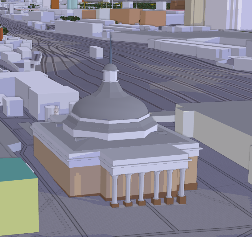
Загадка: Дом без окон, без дверей, полна горница людей. Что это?

Пишите свои ответы в комментариях :)

Сделал еще один такой: Ответ на загадку: Здание в OSM Кажется, это храм какой-то религии. На шпиле вроде был какой-то символ…
P.S. Надеюсь с высотой если и налажал, то не сильно :)

Ich habe ausgehend von einem anderen Projekt, fehlende Hausnummern in einem Ort entdeckt (Langenlipsdorf). Weil ich da aktuell nicht vor Ort sein kann, habe ich die Hausnummern vom Brandenburgviewer übernommen. Als Quelle (source) habe ich nun, wie auf den Seiten des Brandenburgviewer beschrieben den folgenden URL angegeben:

http://www.govdata.de/dl-de/by-2-0

Wie auf der Seite weiter oben beschrieben konnte ich im Brandenburgviewer keinen konkreten Datensatz ausfindig machen.

Frage: Reicht die Angabe des URL für den Source-Eintrag oder gibt es eine bessere Quellangabe?

Posted by a2021 on 14 October 2024 in Japanese (日本語). Last updated on 20 November 2024.

Geofabrik OSM Inspector

何年か前には、広域森林などがよく壊されていた。 エラーチェックにOSM Inspector をよく使った。 近年は OSM Inspector を使っていない。機能が豊富なので、使いこなすのは簡単ではない。

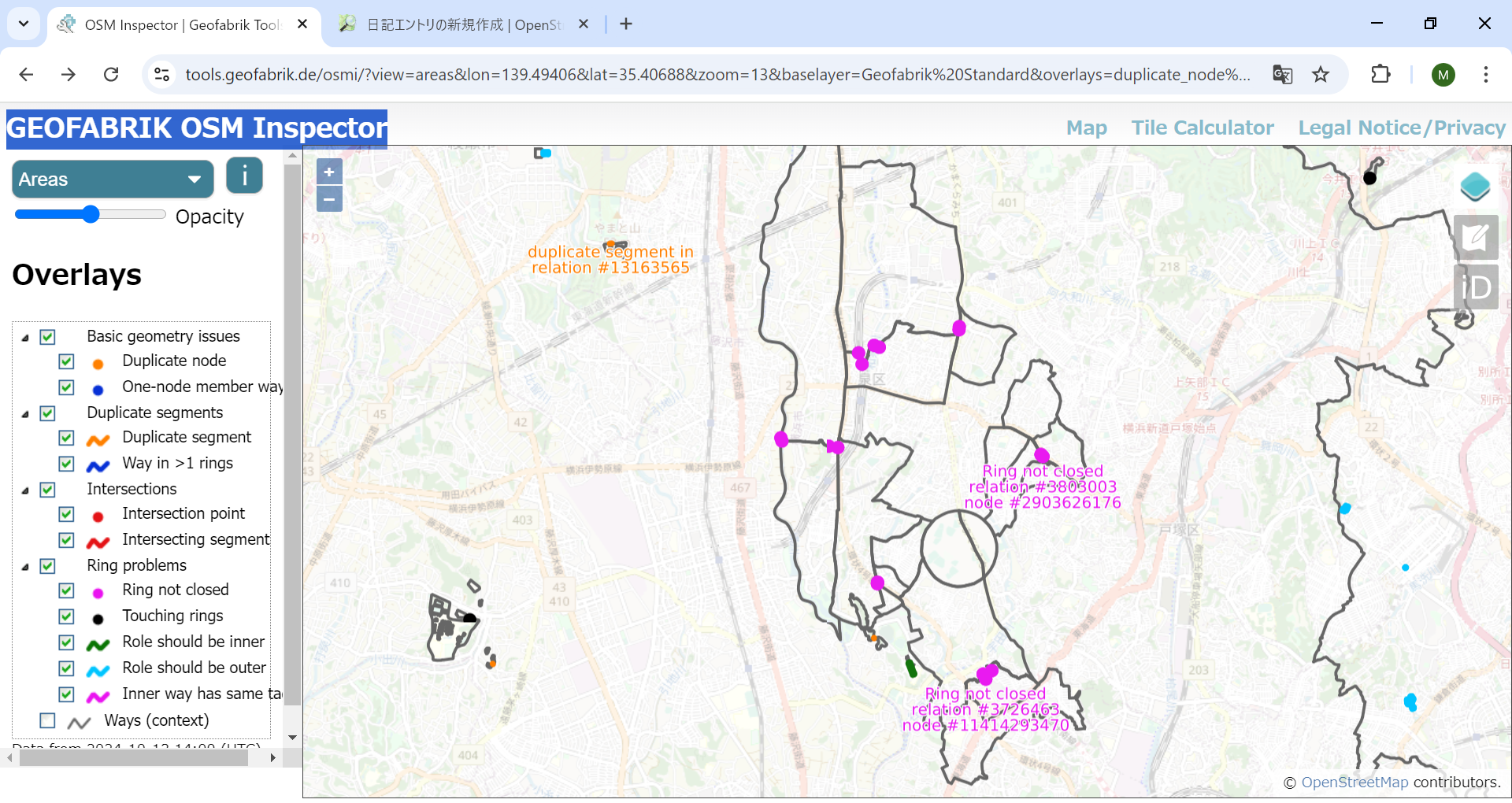
左上の選択は 「Areas」とする。目下、横浜市泉区をマッピングしているので、そのあたりを 表示してみた。

かなり多くのエラーがある。OSM Inspector でエラーを見つけ、relation とか way などの osm_id を JOSM に入れて、エラーオブジェクトを表示する。

二つのポリゴンで描かれた公園の接合部にエラーがあった。合体させて、一つのポリゴンにした。

boundary=administrativeの一部が欠けていた。このエラーは多くある。 とりあえず、簡単な2件のエラーを修正した。

農地をouter polygonとするマルチポリゴンのエラーも修正した。

OSM Inspector にエラー修正が反映されるのは確か数日後であったと記憶する。

今回、4つのエラーを修正したが、まだ多くのエラーが残っている。 境界線エラーが多いと思われる。

誤って消されたとは限らず、分かる範囲で境界線を描き、不明分が描き残されているのかもしれない。境界線が交差のない閉ループにならなければ、エラーとなる。

道路や河川の県境などは現地確認できるが、詳細な境界線の確認には手がかかる。 残りのエラーのいくつかは後日修正するが、修正できないものもあるだろう。

行政境界線を強調表示する[2024.11.15]

日本地図全体では無数のエラーがある。横浜市泉区では、特に、行政境界線のエラーが多かった。いくつかは修正したが、簡単には修正できないものもある。

See full entry

Hello OSM Community,

I’m currently working on a project to capture 360° images of the city of Salzburg for Mapillary, and possibly for Panoramax later. My goal is to enhance OSM data in Salzburg, especially in areas with notes that could be resolved with better visual context—something 360° images can provide.

Getting the Camera

I reached out to the OSM Belgium team to ask if I could borrow one of their 360° cameras. To my surprise, they informed me that there was already a GoPro MAX 360 in Austria! After checking with the local OSM chat, it turned out that mcliquid had the camera and kindly offered to send it to me.

Route Planning Challenges

Before starting the project, I wanted to plan an efficient route to cover as many streets as possible without overlapping - essentially the Chinese Postman Problem. Unfortunately, I couldn’t find a tool for this problem.

Initially, I tried bikerouter.de to created a GPX route. After importing it into OSMAnd, I found that it wasn’t working as expected - it tried to auto-route between the points instead of following the plan I made. This wasn’t practical for me for capturing 360° images.

The Solution I’m Using Currently

I eventually opted to use OSMAnd’s built-in recording feature. By activating the setting, I could record my route in real-time and have the GPX displayed directly on the map. This way, while cycling, I could instantly see where I had already been and decide on the fly which streets to cover next. This flexibility worked much better for capturing pictures around Salzburg.

Managing the Photos for Upload

From past experience, I knew that the Mapillary uploader struggles when handling too many files at once, leading to issues that require a full reset of the uploading-tool.

To avoid this, I used PowerShell to split the images into folders of 250 files each, which made the upload much smoother and basically error-free. This small step ensured that I could process and upload my imagery without hiccups.

See full entry

Location: 47.799, 13.046