 OpenStreetMap

بلط الضعيفي
Users' Diaries
Recent diary entries

Earlier this month during Wikidata Data Modeling Days Hannah Bast from University of Freiburg presented QLever, a SPARQL query engine with some really cool features (slides, recording). After a month of using it, in this post I’ll discuss how it’s relevant for the OSM community and my experience so far.
What’s SPARQL and why should we care?
SPARQL is a query language for RDF data, which can come from RDF-native knowledge graphs (there are thousands of them, public and private, the best known in the OSM community is Wikidata) or other sources (for example OSM) converted in RDF with some tool or middleware
SPARQL includes an optional extension for geospatial data, geoSPARQL. Query services implementing it allow to run all kinds of spatial queries with a naming similar to other query languages based on OGC standards (like SQL on PostGIS).
One notable feature of RDF and SPARQL is that they are made from the ground-up for interoperability between different data sources (“linked data”). SPARQL natively supports querying multiple RDF data sources in one single query through “federated queries”. This works by specifying inside the query to the first service the URL of the second service and its query, then specifying how the result should be merged or joined to the data from first service. If the second service is not blacklisted, the first service will handle autonomously the communication, merge the data and return directly the final output.
QLever
QLever and osm2rdf are two projects by the University of Freiburg; they were introduced respectively in 2017 and in 2021 but only recently started getting attention in the OSM world.
osm2rdf is a tool for converting OSM data into RDF. It transforms geometries from OSM’s node-way-relation format to Well Known Text (WKT) and can indirectly materialize containment and intersection relations between elements to improve spatial querying speed. It’s FOSS and extracts of the data it generates are available online.

I have started an independent collection of OSM SLA statistics. Approximately once a month, I will publish my results with the aim of enhancing transparency regarding the reliability of OSM services. I use uptime-kuma to run monitoring. I also verify connectivity with non-OSM services (to prevent false positives). The current configuration includes checking the availability of openstreetmap-website and openstreetmap-cgimap (API). Tile layer availability is not currently included in the checks. The health-check resolution is set to 30 seconds, and the checks are executed from a single server in the Hetzner datacenter in Germany. For the endpoint to be marked unavailable, two consecutive checks must fail. This should be well-representative of an average user experience.
Summary
Total API downtime: 2 hours 34 minutes 13 seconds
API SLA: 99.643%
Total website downtime: 43 minutes 15 seconds
Website SLA: 99.900%
Note that some functionalities of the website require API to also be available.
Details
2023-11-30 10:07:24 - 2023-11-30 10:09:40
- Total downtime: 2 minutes 16 seconds
- 🚩 API unavailable
2023-11-30 10:16:16 - 2023-11-30 10:21:31
- Total downtime: 5 minutes 15 seconds
- 🚩 API unavailable
2023-11-30 21:34:44 - 2023-11-30 21:36:14
- Total downtime: 1 minute 30 seconds
- 🚩 API unavailable
2023-12-01 04:27:18 - 2023-12-01 04:29:00
- Total downtime: 1 minute 42 seconds
- 🚩 API unavailable
2023-12-01 17:26:20 - 2023-12-01 17:29:20
- Total downtime: 3 minutes
- 🚩 API unavailable
2023-12-01 17:45:06 - 2023-12-01 17:50:39
- Total downtime: 5 minutes 33 seconds
- 🚩 API unavailable
2023-12-01 17:50:39 - 2023-12-01 18:04:09
- Total downtime: 13 minutes 30 seconds
- 🚩 API unavailable
- 🌐 Website unavailable
2023-12-01 18:04:09 - 2023-12-01 18:06:51
- Total downtime: 2 minutes 42 seconds
- 🚩 API unavailable
2023-12-01 18:09:38 - 2023-12-01 18:10:23
- Total downtime: 45 seconds
- 🚩 API unavailable
2023-12-01 18:12:25 - 2023-12-01 18:17:09
Posted by b-unicycling on 26 December 2023 in English.
Last updated on 29 December 2023.

The 30th of November saw the 4-year anniversary of the #osmIRL_buildings project, an ambitious project of the Irish OSM community to map all the buildings on the island. Co. Kilkenny had been the first project to be finished in the task manager in April of 2020, and I thought that it was high time to look at it again.
Since I live in that county, I had noticed missing buildings once in a while being on the road or mapping other things remotely. Relatively new (summer 2022) aerial imagery had been made available by Esri World which wasn’t as clear as Bing, but more recent.
So I decided to make a private task in the task manager and update the whole county by myself. I like to have side quests to make it more interesting, so I decided to also look for unrecorded archaeological sites. The summer of 2022 had been very dry, so crop marks would be more visible on the Esri World imagery. I wanted a private task, so nobody would map any of the tiles, and I might miss something. I usually map the bulk of the other tasks anyway, but I did not want to take any chances. This was going to be the most thorough search for crop marks and other clues to archaeological sites Kilkenny had ever seen. Or so I believe.
All in all, it took me 11 days or 75.5 hours (average time per task multiplied by tasks), but I had excluded Kilkenny city, because I usually have an eye on that all the time.

I started mapping by updating shop details in my area and have now moved on to helping OSMirl in completing the various tasks to get all of Ireland on the map.
I have also started adding buildings to my home city of Port Elizabeth, South Africa. The majority of the suburb (that I’ve worked on) does not have any of the houses mapped.

started to map minor roads and paths in Hahei in the Coromandel, because there sure are a lot of them. already done about 3 minor roads. not that anyone is ever going to use them other than the few locals that already do, but it’s probably got some use

As always at the end of the year comes the time for summaries and plans for the coming year. Since a great deal of my activities is related to OSM I would like to share my plans with you for the the coming year of 2024. Despite not managing to achieve everything I planned (this year, the previous year), there was still a lot going on. So let’s start with a summary of the events of the year 2023:
- I managed to conduct workshops and lectures promoting OSM in several new places, including the Wroclaw University of Technology and Adam Mickiewicz University in Poznan.
- As every year, I promoted OSM’s go at GisDay held at the University of Lodz.
- I conducted several Mapathons, supporting UN Mappers projects.
- I established cooperation with colleagues from Croatia actively supporting them in updating data, and testing the use of building data from city resources and Overture Maps.
- For the first time I took part in SotM, and I intend to participate in such events periodically.
- The OpenAedMap project has received support from CloudFerro, which has allowed us to expand the functionality of the site, and secure the platform for the future.
- The OpenAedMap.org project has gained support in the form of signing more patrons. The Center for E-Health, Warsaw University of Technology and the Medical University of Wroclaw have taken patronage of the project. I hope to expand the list of organizations supporting our initiative even further next year
Unfortunately, the list of plans that didn’t work out is much longer than I would like. This is what happens when there is not enough time or resources, and sometimes things just don’t go as intended.
hi!!!!!! i am new to osm and mapping in general. made my first edit/change yesterday! hopefully many more to come.

Weekly-OSM schreibt doch tatsächlich “Leser:innen”.
Damit haben sie einen Leser weniger.

Day-20
Neis sites
- Neis sites are down for a few days.
- I started my first topic on Discourse regarding this issue. It looks like a single point of failure and actions need to be taken immediately as so many contributors use Neis’s sites and it is not even open source yet.
- This website makes the editing more fun and a game-like experience.
- Surprisingly, I have still been contributing to OSM without the country rankings or main area mapping slowly increasing.
- The last time I checked before the site went down, I was the top 6th mapper in the last two months.
Every Door
- I also learned about an app, Every Door, from my OSM Bengaluru Telegram group. We had a mapping party at Yelahanka this Saturday, but I could not join.
- I localized the Every Door map in Odia language. Let’s see when it will be released to the App.
- This App can help me maintain my 100-day streak.
خزين العجرمية
Yesterday I mapped a tiny area with lots of shops, bars, etc. This stretch of 43rd is so dense and diverse, it is really interesting. There are high-end establishments, but also a church and a food bank, convenience stores, a Mediterranean market. Next survey of the west portion of 43rd I think will go quicker as it becomes more suburban.
Some highlights:
-
I realized I need to add bulletin boards to my ‘look-for’ list - I found two of them in this little stretch, at a cafe and a record store.
-
Did not know there was a Mediterranean market so close to my neighborhood!
-
Found an interesting looking cafe I had never heard of (though it was closed at the time - will check out later)
-
Random excrement bag dispenser in a residential area on the way back - it’s silly but I love finding these, like a rare item in a video game :)

De retour après une semaine “de repos” lors de laquelle j’ai dû subir une opération pour me débarrasser d’une hernie récalcitrante (c’était ça la “raison personnelle” de la dernière fois). Maintenant j’ai droit à deux mois de repos lors desquelles je vais probablement passer du temps sur OSM et à faire des vidéos.
Le micromapping est un peu passé au second plan depuis ma rentrée de l’hôpital avec pas mal de changements du côté d’Ougrée après être passé quelques fois par là ces derniers temps, mais c’est toujours là malgré tout.
Quatre vidéos cette semaine, toutes sur OSM même vu que je suis assez limité dans mes déplacements pour le moment (et la météo craint même si j’en avais la possibilité) :
Améliorons Seraing (sur OpenStreetMap) - Épisode 19 (Ougrée et ses chemins vicinaux (encore)) - Version live de ce changeset où je modifie quelques rues et ajoute quelques sentiers sur Ougrée
Améliorons Seraing (sur OpenStreetMap) - Épisode 20 (L’update de la Bête) - Version live de ce changeset où j’ajoute tout un tas d’habitations manquantes sur Ougrée toujours
Améliorons Seraing (sur OpenStreetMap) - Épisode 21 (Les aubettes de la ligne 27) - Version live de ce changeset où… j’ajoute des abris de bus de la ligne 27 et corrige les arrêts de manière plus générale
Améliorons Seraing (sur OpenStreetMap) - Épisode 22 (Les bus du Beauséjour) - Version live (encore une) de ce changeset où je corrige les lignes de bus au Beauséjour
Et voilà pour cette semaine. Je ne sais pas si je tiendrais cette cadence au niveau des vidéos, mais les updates sur OSM devraient continuer à un rythme similaire.
A+
I am making my way along 43rd St in Kansas City, mapping most of the amenities and businesses I see along the way. About two weeks ago, I went from where 43rd breaks off at Gilham then west to Donutology, and today I worked through the stretch between Donutology and west to the nearby QuickTrip across from the Catholic church. I did not get very far because I walked into many of the businesses and chatted with folks, so as not to be suspiciously loitering outside :D
It was really fun to explore places I wouldn’t normally think to go to. I walked into Gigi’s Health Cafe (the proprietor saw me outside and came out to say hi, so I explained what I was doing and showed her the Every Door app where I was entering her business’s info), and also Paris Banh Mi, which looks like not much on the outside, but is really quite lovely inside.
I have lots of photos that I haven’t decided where to upload yet, but that will be its own project later probably. Along with various points of interest, I started taking photos of all the light poles and street cabinets that I notice which are covered with stickers and/or graffiti. Temporary signs fascinate me. Not sure if there’s a place for photos like those on OSM but I’m keeping them for something at any rate.
On my impression of OSM as a newbie: It looks like there are not a lot of active Kansas City mappers, and that anymore, most of the updates are done by businesses or by people who create / use automated tools, and the most active people are the ones getting deeply into the technical side. A lot of the diary entries I see are about conferences and full of dense technical and/or organizational jargon. Lots of businesses and nonprofits seem to be involved.
Posted by Zkir on 22 December 2023 in Russian (Русский).
Last updated on 23 December 2023.

Продолжение. Предыдущие части тут и тут.
Генерализация в масштабах планеты прошла (ну или почти прошла), и мы наконец увидим, как на самом деле отрисован OpenStreetMap.
Итак, отображаются natural=* и landuse=* :
 Если кликнуть по картинке и выбрать из меню “открыть картинку в новой вкладке”, можно рассмотреть ее в большем разрешении.
Если совсем коротко – Европа (что бы под этим словом не понималось) отрисована более-менее прилично, остальной мир – какие-то лоскуты. Евразийцев не завезли, степи и тундру рисовать никто не хочет. С американскими flyby states не лучше :)

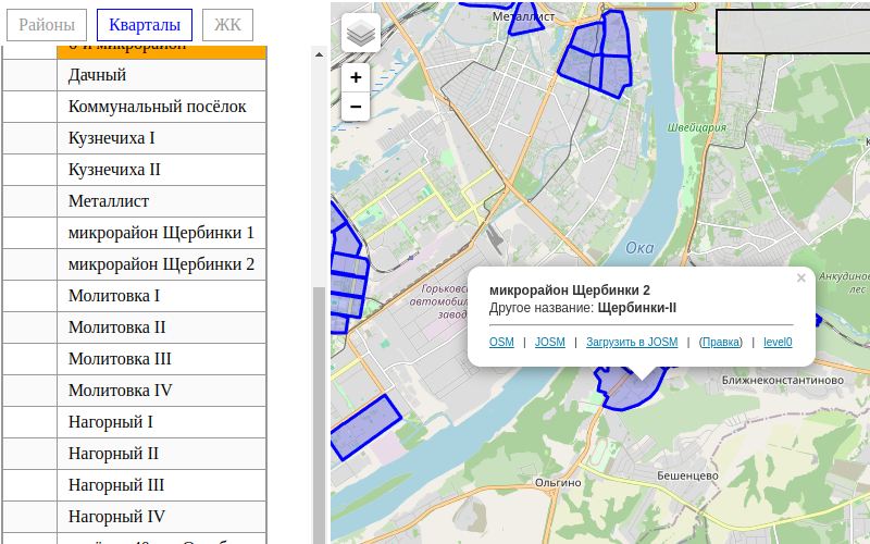
На одной карте удобно проверить правильно ли город разбивается на районы (place=suburb), небольшие кварталы (quarter), а также жилищные комплексы (neighbourhood)

I created my OSM at the beginning of 2023, on December 21, 2023 I created/updated my first map. I guess now this is for the long run.

-
Day 16
I joined OSM back in 2018. Then, there was a movement to use alternatives to Google products. For Google Maps, I found OSM.
Recently, in 2023, I finally started contributing to OSM seriously and continuously. Within around 50 days of contributions, I have already become a member of the OSM foundation and one of the top 10 mappers in India.
I am primarily focusing on:
- Adding buildings in Bhubaneswar, my birthplace area and
- Adding roads in Malkangiri, Odisha.
Today is Day 16 of my 100 days of OSM challenge. Let’s see where I will reach at the end of 100 days.

I have corrected alignments of buildings, shore line, roads for the area from Cherry Hill (NW) to Beaulieu (NE) down to Egmont (SE) and to the airport in the SW.
I’ve added some buildings, deleted others. Made corrections to some and added a few swimming pools. Put in a few roads, tracks, driveways and service roads. Most recently a load of solar panels at the energy company along with associated infrastructure. Fixing the St John’s River as best I could was fun. Not my first or longest and there is likely more to go.
I have reached my first goal: To make a baseline realignment for the SW of Grenada. I might give myself a little break and continue up the west coast to finish St George as the South coast it pretty congested and it will be nice to fix the whole district.