Users' Diaries

Recent diary entries

Posted by un1matr1x on 29 December 2023 in English.

Based on a coincidence, I used Overpass in my area to try to identify objects marked for removal that are older than period X. Unfortunately, I didn’t manage it so easily and at the same time had the idea whether it wouldn’t be better to check this on site via street complete. In the course of the GitHub issue, however, it turned out that it doesn’t really fit the core of Street Complete.

So back to Overpass and the good old query in advance to be able to check it later on site. With the help of other OSM users on Telegram, the following query was created, which can be easily customized:

https://overpass-turbo.eu/s/1Fml

To be on the safe side, the overpass query is shown here as code:

//Check for Stages of decay
//based on the idea of:
//https://github.com/streetcomplete/StreetComplete/issues/5402

[out:json][bbox:{{bbox}}][timeout:800];
//gather informations about non-excisiting objects
//and store the data as "gone"
(
  nw[~"^demolished:.*$"~"."];
  nw[~"^razed:.*$"~"."];
  nw[~"^removed:.*$"~"."];
  nw[~"^destroyed:.*$"~"."];
)->.gone;

//substract any gone-object, that was last modified
//within the last X years
(.gone; - nwr.gone(newer:"{{date:1year}}"););

out geom;

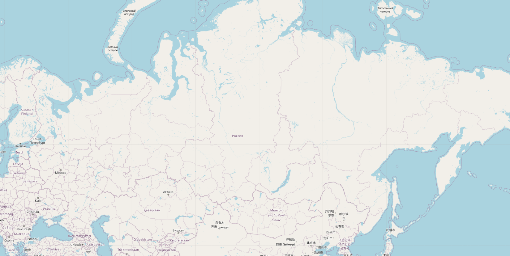
Продолжаем тему генерализации. Как известно, генерализация – это отбор и обобщение той информации, которую мы хотим показать на карте, особенно мелких (обзорных) масштабов.

В OSM c генерализацией все 20 лет всё совсем печально. Напоминаю, мапник на 4-м зуме пустой абсолютно.

Но мы же не будем сидеть сложа руки? Всего несколько строчек кода, и вуаля, на карте появились города:

Посмотреть картинку в нормальном разрешении можно тут.
Видно не только Екатеринбург и Пермь, а вылезла даже Дудинка, Туруханск и Ленск.

Ни у кого такого нет, даже у гугла, а у меня есть. Вот интересно, мне поставят золотые памятники при жизни?

UPD. Вот в комментах пишут, что всё у всех есть, существует даже плагин для QGIS, который умеет вычислять “картографическую значимость” горных вершин и населенных пунктов. Это только на openstreetmap.org генерализации нет, потому что это не интересно osm-cообществу.

Idea

La idea partió desde la busqueda y visualización de Sector III en OpenStreetMap. Al darme cuenta de la práctica inexistencia de edificios y calles además de datos erróneos me creó una “obligación” de arreglar y añadir todo aquello que faltaba en el mapa. No iba a ser fácil pero estaba seguro de que iba a merecer la pena…

En este proyecto, vayamos más allá de lo obvio… La idea “mappear” todo “mappeable”. No pasé por alto cosas aparentemente pequeñas, como papeleras, bancos, farolas y otros “detalles urbanos”. Si bien pueden parecer insignificantes individualmente, hacen que la información sea realmente poderosa, especialmente para aplicaciones basadas en API.

Manos a la obra

El primero paso fue definir y dividir las áreas en las que se iba a trabajar. Dado que el Sector III de Getafe es bastante amplio, habría que dividir el proyecto en varias partes, en concreto en 41 zonas. Cada zona se iba a realizar de manera detallada y uniforme.

Estas fueran las zonas: * Public Areas [X8]

  • Urb. Arroyo Culebro (C. Islas Canarias) [X4]

  • Urb. Las Ladeas (Av. Europa) [X4]

  • Cooperativa Getafe 2001 [X4]

  • Urb. Nuevo Hogar [X4]

  • Buenavista (M. Azaña + 14 Abril + 2da. República) [X3]

  • Urb. Ruiz Alarnes [X2]

  • Urb. General Palacios [X2]

  • Urb. Las Artes [X1]

  • Urb. Cerro Buenavista [X1]

  • Urb. Bañolas II [X1]

  • Colonia Nuestra Señora de Loreto [X1]

  • Urb. Agora Este [X1]

  • Urb. Ivima [X1]

  • Urb. El Artesón [X1]

  • Urb. Pablo Iglesias [X1]

  • Urb. Cerro de la Herradura [X1]

  • Urb. Bañolas I [X1]

Una vez divididas las zonas, tocaba conocer el área. Tanto ayuda local, como diferente fuentes de información (autonómica y nacional) iban a ser clave para hacer un mapa completo y añadir tanta información como sea posible.

See full entry

Location: Buenavista, Sector III, Getafe, Comunidad de Madrid, 28905, España

Заметку оставляю больше для себя. Если есть чем дополнить, пишите.

САЙТЫ

TELEGRAM

  • OSM - русскоязычное сообщество ОСМ. Подпишитесь, прежде чем начать маппить, там всегда помогут, подскажут.
  • Organic Maps - полностью открытые и свободные карты от разработчиков Maps me.
  • OsmAnd - очень многофункциональные карты
  • Новости сообщества ruosm
  • ШТОСМ - блог Ильи Зверева. Лидер русскоязычного Совета OSM
  • JOSM RU-lang - русскоязычный чат по JOSM

СТАТЬИ

OSM Wiki

РЕДАКТОРЫ

Полезная статья

iD - редактор на официальном сайте OSM

Android

  • Street­Complete - очень удобный редактор.
  • SCEE - продвинутый Street­Complete
  • Every Door - Редактор от Ильи Зверева
  • Organic Maps - карты с хорошим, но малофункциональным редактором. Удобен для расставления точек
  • Vespucci - Аналог iD

GNU/Linux

  • JOSM - Свободный редактор OSM. Через него сделано наибольшее количество правок.

Другие ОС

See full entry

Posted by SomeoneElse on 28 December 2023 in English. Last updated on 6 February 2024.

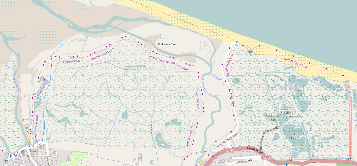
Norfolk coast near Cley

Tidal and non-tidal wetland

A major rewrite here takes into account tags such as natural, reef, wetland, surface and tidal before deciding how to show wetland areas. See the picture above, which is here, and here in OSM.

The beach between high and low tide can be clearly seen here (in OSM, here). There are blue dots in the sand rather than black. A deliberate decision was taken to show more detail for areas above low tide. See e.g. here between Wales and the Wirral (see here in OSM).

Island and islet names

See full entry

Location: Reask, Marhin ED, Kenmare Municipal District, County Kerry, Munster, V92 P681, Ireland
Posted by luziferius on 28 December 2023 in German (Deutsch). Last updated on 25 December 2024.

Ausgangslage

Unser Kenwood-Autoradio im Wohnmobil mit integrierter Navigation (Kenwood DNX450TR, Doppel-DIN-Format) hat das letzte Kartenupdate 2020 erhalten. Die Karten sind nun schon über 3 Jahre alt und zeigen häufig veraltete Geschwindigkeitsbegrenzungen, und es fehlen auch mal Umgehungsstraßen, Kreisverkehre, etc. Kurz, ein Update steht an.

Die Navigationsfunktion im Gerät ist von Garmin, welches als OEM-Partner von Kenwood die Navigationssoftware bereitstellt. Allerdings ist auf der Garmin-Webseite für OEM-Geräte das DNX450TR nicht mehr gelistet. Es gibt also anscheinend keine Kartenupdates vom Hersteller mehr.

Wir wollen auch während der Fahrt nicht vom Mobilfunknetz abhängig sein, entsprechend sind online-Navigationslösungen (Google Maps, etc) keine Alternative. Zusätzlich hat das Gerät keine gute Smartphone-Integration, daher funktioniert die Nutzung von Offline-Navigation auf dem Android-Telefon nicht zusammen mit dem DAB-Radio. Man kann zwar die Sprachausgabe des Telefons auf dem Autoradio ausgeben, hat dann aber kein Radio. Bei Ausgabe über den Telefonlautsprecher regelt natürlich das Radio nicht ab. Also auch keine zufriedenstellende Lösung.

Das teure Radio entsorgen (~ 1000€ Neupreis, wegen des LKW-Modus in der Navigationssoftware (TR = “truck” im Modellnamen)) und durch z.B. ein Gerät auf Android-Basis ersetzen ist ebenfalls nicht zufriedenstellend.

OpenStreetMap für das Kenwood/Garmin Navi?

Es gibt einige Anbieter von Garmin-kompatiblen Kartensätzen, die Liste aus dem OSM Wiki ist gut gefüllt: osm.wiki/OSM_Map_On_Garmin/Download

Aber

Die meisten der gelisteten Quellen sind optimiert für Hiking, MBT, Ski, Radfahren, Wandern, etc. Rendering ist optimiert für Garmin Handhelds mit Displays, die nur 16/64 Farben darstellen können, etc… Manche haben keine Indexsuche, entsprechend keine Adresseingabe, die aber für eine Autonavigation zwingend funktionieren muss. Die meisten angebotenen Karten haben schlicht einen eher inkompatiblen Hauptfokus.

See full entry

Posted by GovernorKeagan on 28 December 2023 in English.

Over the last few days I have been chipping away at validating tasks for the #osmIRL_buildings project.

I have now just finished validating all of Howth. There is still a good bit left in the rest of the county, some of it will definitely be quick due to some areas being rather rural.

Location: Howth Demesne, Ben Eadair A ED, Howth, Fingal, County Dublin, Leinster, Ireland

烦请各位不要动各个厂区内的密集路网图

还有一件事

炼化火坑炼化火坑炼化火坑炼化火坑炼化火坑炼化火坑炼化火坑炼化火坑炼化火坑炼化火坑炼化火坑炼化火坑炼化火坑炼化火坑炼化火坑炼化火坑炼化火坑炼化火坑炼化火坑炼化火坑炼化火坑炼化火坑炼化火坑炼化火坑炼化火坑炼化火坑炼化火坑炼化火坑炼化火坑炼化火坑炼化火坑炼化火坑炼化火坑炼化火坑炼化火坑炼化火坑炼化火坑炼化火坑炼化火坑炼化火坑炼化火坑炼化火坑炼化火坑炼化火坑炼化火坑炼化火坑炼化火坑炼化火坑炼化火坑炼化火坑炼化火坑炼化火坑炼化火坑炼化火坑炼化火坑炼化火坑炼化火坑炼化火坑炼化火坑炼化火坑炼化火坑炼化火坑炼化火坑炼化火坑炼化火坑炼化火坑炼化火坑炼化火坑炼化火坑炼化火坑炼化火坑炼化火坑炼化火坑炼化火坑炼化火坑炼化火坑炼化火坑炼化火坑炼化火坑炼化火坑炼化火坑炼化火坑炼化火坑炼化火坑炼化火坑炼化火坑炼化火坑炼化火坑炼化火坑炼化火坑炼化火坑炼化火坑炼化火坑炼化火坑炼化火坑炼化火坑炼化火坑炼化火坑炼化火坑炼化火坑炼化火坑炼化火坑炼化火坑炼化火坑炼化火坑炼化火坑炼化火坑炼化火坑炼化火坑炼化火坑炼化火坑炼化火坑炼化火坑炼化火坑炼化火坑炼化火坑炼化火坑炼化火坑炼化火坑炼化火坑炼化火坑炼化火坑炼化火坑炼化火坑炼化火坑炼化火坑炼化火坑炼化火坑炼化火坑炼化火坑炼化火坑炼化火坑炼化火坑炼化火坑炼化火坑炼化火坑炼化火坑炼化火坑炼化火坑炼化火坑炼化火坑炼化火坑炼化火坑炼化火坑炼化火坑炼化火坑炼化火坑炼化火坑炼化火坑炼化火坑炼化火坑炼化火坑炼化火坑炼化火坑炼化火坑炼化火坑炼化火坑炼化火坑炼化火坑炼化火坑炼化火坑炼化火坑炼化火坑炼化火坑炼化火坑炼化火坑炼化火坑炼化火坑炼化火坑炼化火坑炼化火坑炼化火坑炼化火坑炼化火坑炼化火坑炼化火坑炼化火坑炼化火坑炼化火坑炼化火坑炼化火坑炼化火坑炼化火坑炼化火坑

As I’ve noted elsewhere, I’m working on moving the JOSM plugin repository from svn to git.

I’ve managed to get something for most authors, but I am still missing attribution information for 47 authors with 95 commits between them.

If you have previously contributed to the JOSM plugin svn repository or the OSM svn repository (which used to include the JOSM plugin svn repository), please reach out to me via OSM messages or email (tsmock@meta.com, taylor.smock@kaart.com, or smocktaylor@gmail.com) if the attribution for your contributions is missing or wrong.

What I need from you:

  • The name you want your patches to be attributed to
  • The email you want your patches to be attributed to
    • As a reminder, this email will be publicly visible via git history. GitHub and GitLab both have noreply email addresses if privacy is a concern for you.
    • Grant Slater (firefishy) has the map used for migrating http://svn.openstreetmap.org/ to git. This will likely be used as a “last resort”; if the attribution from that conversion is OK, then no action is necessary.
  • Optionally, the timezone offset for your patches (UTC±offset)

Notes on the conversion:

  • patch by <foo> commits have been modified such that the originator (“<foo>”) is shown as the author, while the committer remains unchanged.
  • Doesn’t do much to reduce repo size – git lfs could be used for this prior to the final conversion
  • The dist directory for plugin releases has been excluded from the test repository due to size constraints
  • Does not split plugins into their own repositories. This can be done later.
  • plugin externals were converted to submodules; if a plugin had externals in it, those were not converted

WIP Repositories (please do not fork these; I may rebuild them at any time as I get new attribution information):