 OpenStreetMap

Mapa
Users' Diaries
Recent diary entries

This diary is about programming, as my diaries usually are. This diary is about the code, particularly about backend codebase of the HOT Tasking Manager (TM). TL;DR of this diary is: HOT TM code is unmaintainable mess and that will not change. HOT TM developers inherited something they can do nothing about. Please, prove me wrong if you can and end up my frustration.
I will try to find out why Error when trying to split tasks happens, so deep breath and dive.
I suspect backend, so I will omit the note that it could be replicated on chrome browser only. And I will start directly at TasksActionsSplitAPI of backend/api/tasts/actions.py file, because that looks reasonable.
In the first try block I need to find out what is that SplitTaskDTO. I always forgot what “DTO” means. The import line helps and looking into backend/models/dtos/grid_dto.py says it is “DTO used to split a task”. Thanks. But the code looks like the data structure so I merely remember the purpose – just data or alike.
Only the second try left, so let’s see. The comment on the first line says it checks the project exists. I am just curious how it’s implemented, so see backend/services/project_service.py to find out exists method. Side note – I completely misunderstand classes with static methods only. Oh, exists is just Project.exists. How is that implemented? Just curious… See backend/models/postgis/project.py to see that exists is… it looks like a database query. I don’t SQLAlchemy, but note the first database request. I will number them, this one being #1.
We are back at the second try. It looks the main work is done in split_task of backend/services/grid/split_service.py, so see that (static again) method. Well, heh, not funny anymore. But I am not going to give up easily this time. So split_task now.
Posted by mappinglander on 20 December 2023 in Turkish (Türkçe).
Last updated on 27 December 2023.

Geçtiğimiz günlerde Telegram grubunda bununla ilgili mesajlar atılmış, üzerine tartışılmıştı. Bunun üzerine ben de tüm noktaları özetlemek istedim. Şöyle ki;
-
OSMF kullanım şartlarında belirtildiği gibi bu konuda OSMF haklı olarak herhangi bir sorumluluk üstlenmiyor, herhangi bir garanti vermiyor. Sonuçta gönüllü haritacılar olarak yerel yasalara uymak zorundayız, bu bir.
- İkincisi ülkede halihazırda belli bir ölçekten daha küçük ölçekte harita yapmanın yasak olmasını veya herhangi bir haritalama faaliyeti için yüksek miktarda para ödenmesini, bu sayede Basarsoft’un tekelini geçtim; bunun dışında Askeri Yasak ve Güvenlik Bölgeleri Kanunu’nda oldukça geniş yasaklamalar da var askeri bölgelerle ilgili .
-
Üçe gelirsek, şu anda devlet/belediye kaynaklarından haritaya aktarılan çok fazla veri var. Bu verilerin çoğu telif haklı/ticari kullanıma izin vermiyor/lisansı açık kaynak lisansı olsa da OSM ile uyumsuz. Dolayısıyla yasal olarak gri bölgeler oluşuyor, belki biraz da bu tarz durumlarla ilgili çok fazla dava, mevzuat vs. olmadığı için (sonuçta kim Türkiye’de Creative Commons lisansı kullanıp da yanlış kullanan birini mahkemeye verir?). Bu kurumlar “Bak, ama kullanma” politikası güttüğü sürece de bu tarz işleri tehlikeli görüyorum.
- Dört: İkinci maddeden dolayı yerel bir OpenStreetMap organizasyonu/yerel derneği kurulamıyor, allahtan Yer Çizenler bu açığı bir nebze dolduruyor.
Dolayısıyla, birçok devlet kurumuna ve hatta geçtiğimiz seneki Maraş depremlerinde arama-kurtarma takımlarına OpenStreetMap oldukça yardımcı olmuş olsa da, ben de OpenStreetMap’te haritalama yapmayı sevsem de bunun gibi durumlardan dolayı daha az katkı sağlamayı düşünüyorum. Daha önceden de dikkat ediyordum ancak bu saatten sonra da başıma bela almamak için askeri bölgeleri haritalamamayı tercih edeceğim gibi duruyor.

พิมพ์นิยม

“The beauty of a tech journey lies in the shared struggles 🧩”

The quote above is a reminder that success is not a solitary path but a collective triumph over challenges. Everybody struggles 🤷🏽♂️. Tech’s greatest minds that we know today didn’t escape the struggle; they transformed it into the foundation of their success story. How about that?
The journey to breaking into the ever-evolving landscape of the tech industry can be challenging and daunting. From the overwhelming available knowledge to the diverse backgrounds that contribute to the beauty of the industry. You may want to grab a cup of coffee if you can, let’s quickly delve into the shared experiences that unites aspiring open source enthusiasts worldwide :)
The Struggle is Real
Posted by Zkir on 19 December 2023 in Russian (Русский).
Last updated on 21 December 2023.

Запустил импорт планеты в postgis, чтобы посмотреть покрытия для всех стран, но osm2pgsql за сутки планету не переварил. Эх, osm2pgsql такая большая заноза :(

Причем даже не сказать, что комп нагружен.
Posted by Vinber on 19 December 2023 in French (Français).

À l’occasion de la publication de “Se former à OpenStreetMap” sur le site de l’association OpenStreetMap France https://www.openstreetmap.fr/se-former-a-openstreetmap/, quelques retours sur la génèse de ces contenus pédagogiques.
Paru au bulletin officiel de l’éducation nationale, de la jeunesse et des sports, le bulletin officiel spécial n°1 du 22 janvier 2019 fixe le programme d’enseignement de Sciences Numériques et Technologie (SNT) de la classe de seconde générale et technologique.
Dans la thématique Localisation, cartographie et mobilité du programme en annexe, il est fait mention de contenus dans lesquels on trouve la capacité attendue Contribuer à OpenStreetMap de façon collaborative (page 15 de l’annexe ci-dessus).
Février 2019, la découverte pour OpenStreetMap-France
Lors du conseil d’administration des 2 et 3 février 2019, l’association OpenStreetMap France a appris par l’intermédiaires d’adhérents (contributeurs et enseignants) l’existence d’une nouvelle capacité en classe de seconde Contribuer de manière collaborative à OpenStreetMap. Déja évoquée sur le forum en décembre 2018 (https://forum.openstreetmap.fr/t/osm-et-enseignement-snt-en-lycee/2988), la question de la formation des enseignants y est abordée et des pistes d’activités pédagogiques également. Le point sera à l’ordre du jour du conseil d’administration en présentiel suivant (osm.wiki/France/OSM-FR/CA_2019-02-03#Ordre_du_jour_du_CA_physique_2-3_f%C3%A9vrier) sans beaucoup de suites. Aucun contact n’a été pris avec l’association OpenStreetMap France par le Ministère de l’Éducation Nationale.
De “mauvaises pratiques”
It’s wonderful to discover such beautiful and accurate mapping.
I checked my location in the Open Street Map and saw how accurate the buildings were mapped in the vicinity where I live in the province. It gave an accurate sizing of our location, which I found great.

🎊🎉 Rumo aos 30…..

I mentioned in my previous post about why it’s great to meet up with other mappers. One thing that someone suggested I write a diary about is the method I found to be notified about map-worthy changes to one’s local area. It turns out that not everyone has heard of the London Gazette, its role in local law and administrative changes in the UK, and the online services it offers to help discover the changes.
So here’s the Wikipedia page for the Gazette And here’s the website
The core of the publication is the notices. The rules of the road network for residential and even some of the more major roads in an area (pretty much everything that doesn’t constitute the trunk road network) are delegated to local authorities, and the ritual incantation they have to go through to change those rules is to publish notices in the local press and in the London (or Edinburgh or Belfast) Gazette.
In the navigation bar at the top of the page is a Notices menu, which will list all the most recent notices in the UK.
There are filters on the left hand side of this page where you can search for and filter the list to the particular notice type and area you’re interested in. For my local area, for things I might want to add to OSM, I’ve found that the following customisations work best:
-
restricting the list to Notice Code 1501
-
filtering the location by Local Authority from the drop-down box (in my case, the London Borough of Ealing)
-
Hitting the “Update results” button and then changing the sort order to “Latest”.
I attended my second OpenStreetMap London social today. They happen approximately once every two months, but it’s been a year since my first one. It’s daunting, going to a pub in central London to meet a group of strangers, especially if you’re not the most outgoing person and your expectations are that they won’t be either. So I just wanted to recommend it. When you have a niche interest such as mapping the world for no particular return other than the vague idea that this stuff is really important and will change the world, it’s great to meet a few other people who feel the same way. Whether it consumes all your free time, or is just something you spend 15 minutes doing when you visit a new place, it’s brilliant to get perspectives from other mappers, to hear what motivates others, to see what they are doing with the data you contribute, and get some tips on things you might not have heard about. I can’t remember where I heard about the London meetup, but reminders are usually posted to the talk-gb mailing list, to the weeklyOSM newsletter, and to the OSMCal website, so do check those places out for updates.
Posted by joyceeemaeee on 18 December 2023 in English.

I want to share that I received the “State of the Map Asia 2023 Community Champion Awards” on November 17 as recognition for advocating the use of OpenStreetMap and community-building across different groups and regions in the Asia-Pacific region and promoting diversity, equity, and inclusivity within the community.
As a student leader passionate about exploring not just maps, but also the diverse tapestry of communities in the Asia-Pacific, I recognize that my efforts are a work in progress. I aim to continue advocating for OpenStreetMap’s advancement and I am deeply grateful to the State of the Map Asia team, my colleagues, mentors, family, friends, and everyone who has contributed to this remarkable journey.
Posted by Mateusz Konieczny on 18 December 2023 in English.

It is one year since I was elected to OSMF board.
I am recording time spend on some things, including time spend on things resulting from being on OSMF board.
So I can report that since 2022-12-09 it was 355 hours.
It records time spend on what I do as result of being on OSMF board. So it excludes for example time spend on mapping and StreetComplete development. And it includes time on some things that I could complete without being on OSMF board like some attribution-related activities - that I do as result of being on OSMF board.

اعليمات الدفة


I feel like I owe the world this, I owe Zimbabwe this, we can’t step into the new year before I share this news with everyone. It was June of this year when I was voted as a New Voting Member. I am grateful for a supportive nominator Kingsley Chika CHUKWU and the HOT family as a whole. I might be the first Voting Member from Zimbabwe and for this I was compelled to share this step with the rest of this family especially.
Getting to be a Voting Member came with proving your worth and making sound suggestions and decisions I am already incorporating or taking part in. I am happy to be recognized to this extent and I promise to stand in for the community, to the community as we build a stronger community. You can read my responses here:
مضخة بلغنية
ابلطة الزياق
Posted by Zkir on 15 December 2023 in Russian (Русский).
Last updated on 21 December 2023.
Так ребята, всем привет, особенно тем, кого давно не видел. ;)
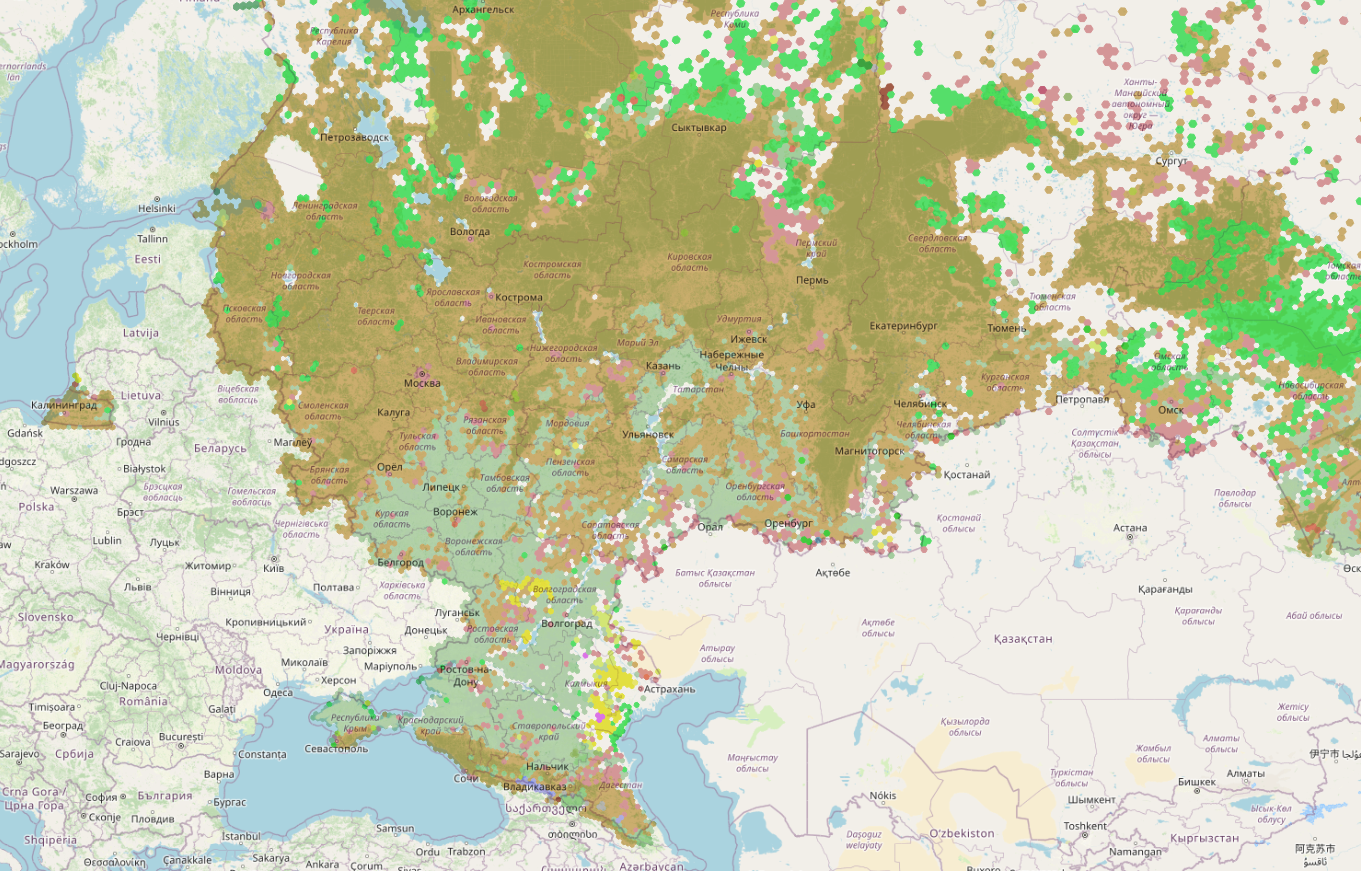
Сделал наконец то, что собирался сделать уже года два: генерализованную карту “покрытий”, они же land covers, на основе данных OSM.
В русском географическом языке, кажется, такого слова нет, ближе всего подходит наверно “тип ландшафта” или “доминирующий тип растительности”: то, что покрывает землю и определяет, как то или иное место видно сверху. В основном это растительность: леса, кустарники, степи, поля, луга, но если растительности нет, то то, что есть: городская застройка, пески, голые камни, пляжи.
Как оно считается: поскольку последовательной классификации land covers в osm нет, то берутся все landuse=* и natural=*, и сопоставляются с гексагональной сеткой (h3). Для каждого гекса определяется тег, полигоны с которым в данном месте занимает наибольшую площадь, и таким образом этот тег является наиболее характерным.
بير عقيرة الدويمة