
De vuelta al mapeo
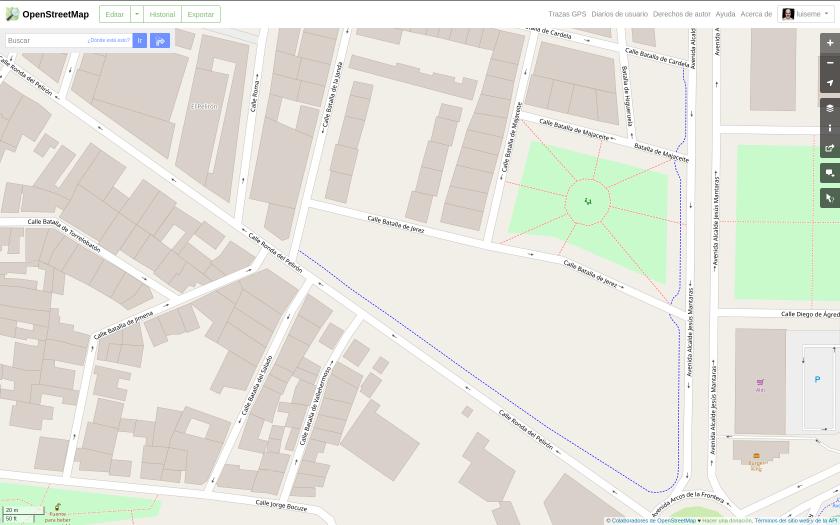
Hoy he subido el trazado de un carril bici de nueva construcción en mi ciudad.
Para esta labor me he servido de una traza gpx generada con la aplicación móvil GPS Logger.
 OpenStreetMap
Hoy he subido el trazado de un carril bici de nueva construcción en mi ciudad.
Para esta labor me he servido de una traza gpx generada con la aplicación móvil GPS Logger.
2021年1月10日、オープンストリートマップのアカウントを登録しました。
トランプ大統領の選挙で世界中が大騒ぎです。ぜひ、トランプ大統領には2期目も継続して活躍してもらいたいと思っていますが、非常に厳しい状況です。そして、現在、トランプ大統領、その他のアメリカ保守層の政治家等のTwitterなどが、停止されてしまったり、YouTubeが配信停止されたり、言論の自由が脅かされています。長年親しんできたグーグルマップですが、こうした状況下で、このさきどのような行動をグーグル社がとるのか不安が増してきています。1月20日に次期アメリカ大統領が誰になるかまだ分かりませんが、いずれにせよ、自由を求める世界的な戦いは、これからも続いていきます。
このような時期にオープンストリートマップの存在を改めて知り、こうしてアカウントを登録できたことはうれしい限りです。ほんの少しでも、誰もが自由に使えて、自分たちで自由に育てていける世界が広がることができればいいと感じています。
これまでオープンストリートマップを支えてきた数多くの皆様と、これから支え続けていくであろうすべての人々に感謝いたします。
If anyone is interested, I have started a series of YouTube tutorials to help historically interested people discover OpenStreetMap and learn how to use OSM, uMap etc. I’m using Ireland as an example, but some things might apply to other countries as well: YouTube Playlist
I started with the “basic basics”, because the majority of people in Ireland have not heard of OSM unfortunately.
Bonjour à tous et bonne année.
Depuis ce 1 janvier 2021, l’intégralité des données publiques de l’IGN sont placées sous la licence ouverte Etalab, c’est-à-dire une licence équivalente à la licence Creative Commons Attribution (CC-BY). Ces données publiques comprennent les données vecteur et les photographies aériennes ortho-rectifiées (orthophotos) ce qui représente une base de donnée considérable.
Ainsi, la page de téléchargement des données IGN sous licence ouverte est à présent massivement fournie.
It’s really strange the fact that, after you went multiple times in the same zone, you still find little details to adjust on osm the next time you are there. Maybe you can add some surface, maybe there’s a little path you never went through, maybe you discover a little spring you never noticed.
I think the optimal way to handle this kind of “zones” would be to reside there for 1-2 weeks and complete it (if that’s even possible).
It still remain awesome the feeling of unknown you have in the mountains, where there are hundred of little paths that nearly nobody have used in the last years. I really feel like an explorer!
არაფელი ხდება ახალი..დასვენების დღეა და ვცდილობ დავისვენო არ დავლიო ..ვზივარ მარტო ,.სულ ესაა
بسم رب شهدا و صدیقیق بیژن خان رودباری نام یک پهلوان و شمشیر زن بزرگ ونماد رشادت و راحش شهادت در راه حق علیه باطل و هدفش چیره شدن روشنایی بر سیاهی ایشان در یورش اعراب عمانی به سرکردگی شیخ مسقط شیخ سیف و شیخ نبهان خارجی مذهب در قلعه گلاشکرد در سمت حاکم و امیر رودبار و بشاگرد پس از شهادت سرتیپ امیر حسین خان به دست افغانها به این مهم رسیدند و توسط یکی از خائنین اطرافش از پشت با نیزه به شهادت رسیدند و رودبار کهن دوره ۲۰ساله تاریکی را تجربه کرد تا سرتیپ امیر سعید خان و امیر میرزا خان پسران امیر حسین خان و برادر زادگان بیژن خان دوباره قلعه کهنوج را از اعراب و خائنین پس گرفتند و سالها جنگیدند تا پسر سعید خان امیر نورالدین خان در آخرین جنگ با کمک برادر رشیدش و دلاوران ۷۰ طایفه فاتح رودبار و بشاکرد خاک ایران عزیز را لوس وجودشان پاک کردند و در انتها از رودخانه هلیل کانال آبی بزرگ به دشت رودبار آوردند و دهی تاسیس کردند و نامش را بیژن آباد گذاشتد بنا به یادبود شهید بیژن خان قابل به ذکر است دقیقا مکانی بنام ریک آسیا در ۱۵۰۰متری به طرف شمال محل سکونت بنده هست دارای آسیاب بسیار بزرگی دال بر قدمت چند صد ساله دارد و همچنین قلعه و زیارت و در آخر از لحاظ جغرافیایی هم اگر دقت کنید از مظفر آباد الان تا چیل گرگ فقط سه آبرفت وجود دارد زیرا در قدیم محل سکونت بوده مخلص کلام بترسید از روز قیامت که بیت المال مملکت رادر مکانی اشتباه خرج کنید و اموال جان مردم را سیل و زلزله تهدید کند والسلام سند تاریخی هم سفرنامه عبدالحسن میرزا فرمانفرما
In December, HOT launched a new pillar of work under the name “Transformation and Community.” This pillar will be formed of six teams: four regional hubs, the community team, and the communications team. The Transformation & Community pillar exists to reorient HOT’s work and to serve humanitarian OpenStreetMap communities, individuals, and organizations worldwide. Facing the task of supporting humanitarian OpenStreetMap community growth across 94 countries, over the past few months we’ve established a Community Team, taking the opportunity to welcome exciting (and some familiar) faces into the HOT staff team.
Who are they? Arnalie has been advocating for a more diverse and inclusive OpenStreetMap community since she first became involved in 2016. She is passionate about building inclusive spaces in the OSM community - where the communities that we serve and map are prioritized, listened to, and are able to voice their concerns. Her professional background is as a GIS specialist, using OSM for projects supporting disaster risk reductions and management in the Philippines (e.g., Project NOAH - WebSAFE and ISAIAH), and OSM for social welfare and development (e.g., the Department of Social Welfare and Development’s MapViewer and MAPAbabae). Alongside OSM Philippines, she is a member and supporter of various local mapping collectives in the country, such as GeoLadiesPH, Ministry of Mapping, UP Resilience Institute Youthmappers, Mapbeks, and Mental Health AWHEREness.
Como todos sabemos a escola pública vive sempre com grandes dificuldades financeiras e por isso é impossível que estas obtenham os programas informáticos de que necessitam, uma vez que o custo das diversas licenças se torna incomportável. Assim, a utilização de programas de dados abertos torna-se na melhor solução, uma vez que gratuitamente nos permite trabalhar diversas competências com os alunos. O curso de Técnico de Desporto, da Escola Secundária Jerónimo Emiliano de Andrade utilizou o UMAP para criar um mapa com os locais de nascimento dos jogadores de futebol da primeira liga portuguesa. Assim, será possível que toda a comunidade escolar perceba que o desporto, neste caso o futebol, é uma realidade intercultural e que fenómenos como o racismo, a xenofobia e a intolerância não podem pertencer a este mundo. O mapa intitula-se “Futebol em Portugal é intercultural!”

I’m happy to announce that this week I’ve joined the Humanitarian OpenStreetMap Team as Community Strategist and Research Lead.
In my new role I’ll be working to support the Humanitarian Open Mapping Movement by building strategies and initiatives based on quality data and research, as well as identifying opportunities to further the Audacious project aims.
We will scale up the support to local mapping communities with the aim of mapping an area home to one billion people, adding places at high risk of natural disaster or experiencing poverty in more than 94 countries worldwide.
Стихийные бедствия, катастрофы, опасность - Заготовка тегов для JOSM , закроем пробел по тегам очень важных явлений.
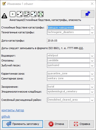
ссылка для скачивания заготовки https://github.com/Sowa1980/Natural_disasters_disasters_danger_preset
Подключить заготовку тегов в JOSM можно, запустите JOSM: далее в меню “Правка” выберите пункт “Настройки” или нажмите (F12) в открывшемся окне с лева выберите икону “Параметры проекции” (третье сверху) откроется окно “Настройки карты” далее перейти на вкладку “Заготовки тегов” в правой стороне нажмите на+, в открывшемся новом окне в строке “Название (необязательно)” задайте желаемое имя в строке “URL / файл” укажите путь до скаченного файла (формат файла должен быть *.xml или *.zip).
Приму замечания и пожелания по заготовке и тегам, если знаете более точное название как будет звучать на английском исправлю, пишите. обсуждение в группе https://t.me/OSM_BelRusUkr
hi, I saw in the municipality the Vanzago border map, and the 5 houses between Via Allende and the railway rails, are put in Pogliano Milanese administration. How we can be sure of the real position of the border?
Quand j’ai commencé à cartographier en septembre, la ville n’avait aucune (ou quasi-aucune) adresse renseignée. C’est pourtant une donnée essentielle à mes yeux. Par exemple, lorsqu’on utilise OsmAnd comme GPS pour trouver un endroit précis, soit le POI est renseigné et c’est bon, soit l’adresse permet de se situer correctement. Dans le cas de voies très longues, cela prend tout son sens.
Alès est une des deux sous-préfecture du Gard, 2e ville du département avec 40 000 habitants. Dans JOSM, je trouve environ 154 000 bâtiments (building=yes). En retirant les bâtis sans murs (wall=no), on tombe à environ 144 000 bâtis. Il reste encore à enlever les dépendances, armoires de rue… mais cela donne une idée du volume de travail.
Afin de ne pas trop désespérer n’y de m’engluer, j’ai décidé de procéder par zones et par étapes. L’avancement par zone me permet de me rendre compte de l’avancé du projet et de rester motiver ! La première zone définie est le centre ville. Je pense que j’avancerai par zone de densité de population. Je serai ravi de laisser les volontaires compléter des secteurs avec moi ;) (signalez-vous dans les commentaires)
L’avancement par étapes permet d’avoir une stratégie claire dès le départ et évite de devoir corriger en masse quelque chose qu’on n’aurait pas anticipé. Voici les étapes que j’ai identifiées :
osm.org/relation/3823410 Кому-то, как всегда, неудобно воспользоваться Overpass Turbo или осилить пространственные запросы к БД.
Но поскольку уже выросло целое поколение игрунов, для которых не существует критериев правильности вроде отсутствия избыточности и так далее, есть только критерий объема получаемого удовольствия (а любая критика или ограничения - фактор, обратный удовольствию), о чем тут можно спорить?
Une nouvelle année démarre et c’est l’occasion d’imaginer les voeux à souhaiter pour OpenStreetMap et sa communauté.
OpenStreetMap a démarré à partir d’une feuille blanche il y a plus de 15 ans pour créer le plus grand commun cartographique qui soit.
Ce commun existe par l’engagement de personnes aux profils et motivations diverses.
Petit à petit, cette carte blanche s’est remplie avec des données collectées par des contributeurs “chasseurs”. À l’époque préhistorique d’OSM, il fallait en effet aller sur le terrain, équipé d’un GPS, d’un bloc-note et d’un crayon, pour prendre des notes puis reporter ça sur la feuille blanche, sans autre point de repère.
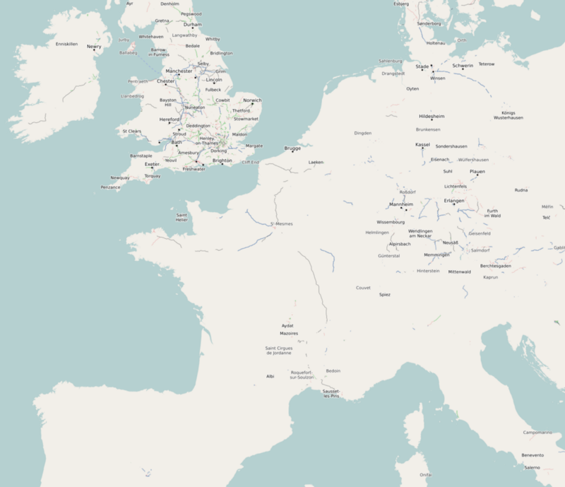 OpenStreetMap au 1er Janvier 2007
دانایی با دانش سلامتی با ورزش
Hi everyone!
Delighted to announce that proposals are in for the hOSM Summit Grant 2020. One grant of $5000 is available to an OSM community that attended at least one of the sessions at the summit (supported by ESRI). In addition to being provided support, mentoring and training during the grant period, one team member will attend and present their project at the Humanitarian OpenStreetMap Summit 2021 (date and location TBD).
Proposals can be found here: osm.wiki/Humanitarian_OSM_Team/HOT_Microgrants/Humanitarian_OpenStreetMap_Summit_Grant_2020
If you have some time and would like to give comments/feedback you can do so on each proposals Discussion page. And if you’d like to endorse a project, please do so (this will be taken into consideration during the final selection process).
Instructions to add an endorsement: 1. Log in to the wiki if you are not already logged in. 2. Scroll down to Endorsements and click ‘Edit source’. 3. Add your reason for the endorsement followed by four tilde signs: ~~~~ [Note: The ~~~~ automatically inserts your name and the current date.]
Final review will take place on Monday 18 January so please make endorsements and/or give feedback before then, so that we can take your opinions into consideration.
Thanks!!
Lately I’ve been using uMap to map the local fat bike trails to let local riders know where they are. The trails are just snow so they can get buried by more snow and shift position when re-groomed or abandoned. Come spring they melt away.
I like that I can do most of my gpx line editing in JOSM then import to uMap for final formatting.
El editor JOSM dispone de un complemento llamado PicLayer que permite usar imágenes como fondo del editor para añadir datos al mapa a partir de ellas. Recientemente he tenido ocasión de usarlo para añadir los contornos de un parque forestal gestionado por el Ayuntamiento de Málaga.
Los contornos de este parque eran bastante difusos. Yo mismo los añadí hace algún tiempo sin tener claro dónde empezaba o terminaba el parque. Se encuentra en un espacio abierto que hasta hace poco no disponía de señalización alguna sobre el terreno, integrado en un espacio más amplio que tampoco queda claro donde empieza o termina, el entorno del embalse de El Limonero. En esta parte del mapa, los únicos límites claros son los del jardín botánico La Concepción (que está vallado) y poco más. Recientemente han instalado un cartel informativo con un mapa de situación en el que se dibujan claramente los límites del parque.


