Users' Diaries

Recent diary entries

Nos ultimos dias inseri nomes de Ruas nas Cidades de Jaboatão dos Guararapes, Grávata e Tupanatinga com a camada Atualizada do IBGE 2019, cidades que precisava de Melhorias nos nomes de Ruas.

-State of Pernambuco - Brazil. http://geoftp.ibge.gov.br/recortes_para_fins_estatisticos/malha_de_setores_censitarios/censo_2010/base_de_faces_de_logradouros_versao_2019/PE/

O Camunidade Openstreetmap de Pernambuco está trabalhando para melhorar ainda mais os nomes de Ruas nas Cidades de Pernambuco.

Atenciosamente,

Raphael de Assis

UMBRAOSM

www.umbraosm.com.br

Update of the IBGE 2019 Census Sector Network. Published by raphaelmirc at 27 December 2020 in Brazilian Portuguese. IBGE has updated its 2019 Census Network and made available for Donwload with states and municipalities, click on the link and choose which state you want to download.

File used as an IBGE layer in Josm to include street names.

-State of Pernambuco - Brazil. http://geoftp.ibge.gov.br/recortes_para_fins_estatisticos/malha_de_setores_censitarios/censo_2010/base_de_faces_de_logradouros_versao_2019/PE/

-Brazilian states. http://geoftp.ibge.gov.br/recortes_para_fins_estatisticos/malha_de_setores_censitarios/censo_2010/base_de_faces_de_logradouros_versao_2019/

Raphaelmirc

Recife PE.

Member of FOSM.

Member of UMBRAOSM

www.umbraosm.com.br

Posted by MKnight on 1 January 2021 in German (Deutsch).

Und wieder mal paar Statistiken aktualisiert,

zum einen die Kilometersteine, haben wir in 2020 ein Plus von 500 und werden bei dem Tempo 2023 oder so die 20%-Marke geknackt haben… ;)

Zum anderen Notrufsäulen, sind 60 Stück dazugekommen. In dem Falle ist das recht viel, da die Abdeckung im Gegensatz zu den Milestones recht hoch ist. Ich schätze deutlich über 80%

osm.wiki/User:Dex2000#highway.3Dmilestone_DE ff.

Posted by bo_hot on 1 January 2021 in English.

you get credit for what you finish, not what you start - unkown

Today is the day to put our ideas into the hands of the people that face the problem.

For those that haven’t heard of Paulo Freire, to introduce him here would not do him justice. However, he fundamentally shaped me both personally and professionally.

‘The people that face the problem, are those best placed to solve it’. - Paulo Friere

There is little I am more passionate about in this world than this statement.

It is for this reason, that Friday is one of my favourite days in the design sprints. It’s the day where we finally get to see if our listening and learning was translated into something that will help people solve their problems. Ultimately it is a day of practicing deep humility.

Whoever teaches, learns in the act of teaching and whoever learns, teaches in the act of learning. - Paulo Friere.

And that’s what we’re here to do. Learn. We are in search of the golden equation: problem + solution = value. Ultimately this is what matters most - no value, no solution.

And once we have found a solution of value? Evolution.

To be continued…

The end of one story, is the beginning of many more. - unkown

Location: Zetland, Sydney, New South Wales, 2017, Australia
Posted by qeef on 1 January 2021 in English.

Divide and map. Now. helps mappers by dividing some big area into smaller squares that a human can map.

It’s been a year already since I announced the damn project, so it’s time to summarize the first year of development.

For mappers

I finally managed to make the manager manager-friendly. There is news for the client, too. Along with mapping random or recent squares, a mapper can choose to map the nearest square. Moreover, reviewers can review a newbie square.

I added background OpenStreetMap for the squares. When you click on a square, you may lock that square manually. When you lock multiple squares, you can merge them.

A mapper can share the link to an area or a square. A mapper can download the client and open it on the computer (saving 96KB of bandwidth next time.)

I fixed bugs of the damn plugin reported by #OSMWorldDiscord guys (Thanks again!) and added the “lock & open in JOSM” link to the client.

I wrote a new client. Wondering, how the integration without integration to iD editor looks like? Open the panel and check it out.

For communities

Divide and map. Now. has a separate repository for the deployment. You need to change seven rows in the config files (five rows with security and OpenStreetMap OAuth tokens, one row with the domain, one with the email address) and create one empty file. And you are ready to go.

I was wondering what is missing in the basic setup. I mean – the minimum you need to run is the server. You probably want a client and manager, too. That’s all. You know – the damn project helps mappers …

However, you are part of a community changing the world. The client and manager are OK, but you probably want to tell others about the community.

See full entry

Deja Vu, again :)

This is now the 3rd annual instalment of a crazy naval-gaze about my mapping. Blame it on whoever called this part of the osm space a diary. If there is a chance to speak about my personal reflections I’m grabbing it. And what better time of year than now, since I see other people reflecting and goal setting.

My Targets

I wrote about measuring my own commitment to mapping in 2019 and then again in 2020 for the years ahead. It was fun to see my objectives shift around and good for me to test myself against them. In 2020’s diary I then had to be like the Roman God Janus; to look to the previous year by way of review, and to the coming year by way of promising some targets.

My Hot Spot

Last year I undertook to have my hot spots look less like the measles and more like a large boil, and for that boil to be in Ireland. This is definitely the case now, as the graphic shows (use the slider to see the expansion of mapping in Ireland). Having achieved this I’m not concerned with continuing to make a target for this in 2021.

My Ireland Contribution Rank

Again, the target was to stay in the top 10 mappers in Ireland. It was sustained in 2020, but there was one occasion in July where I dropped out of the top 10. I am presently the 5th biggest, without too much effort. Since I technically didn’t keep this one I will go forward with it and try to stay in the top 10 in 2021.

In the past year I realised that Pascal Neis’s “Ireland” is in fact only the Republic of Ireland. A lot of my mapping is in Northern Ireland, and as a consequence shows up in the UK. This about 20% of my present mapping.

As an extra kick I’m going to try to develop a tool that shows all the mapping on the whole island of Ireland, and this itself can be a target since it would be of benefit to everyone involved in mapping Ireland.

Map on the move

See full entry

Posted by Richard on 31 December 2020 in English.

As many of you will be aware, Flash Player is about to be disabled in web browsers.

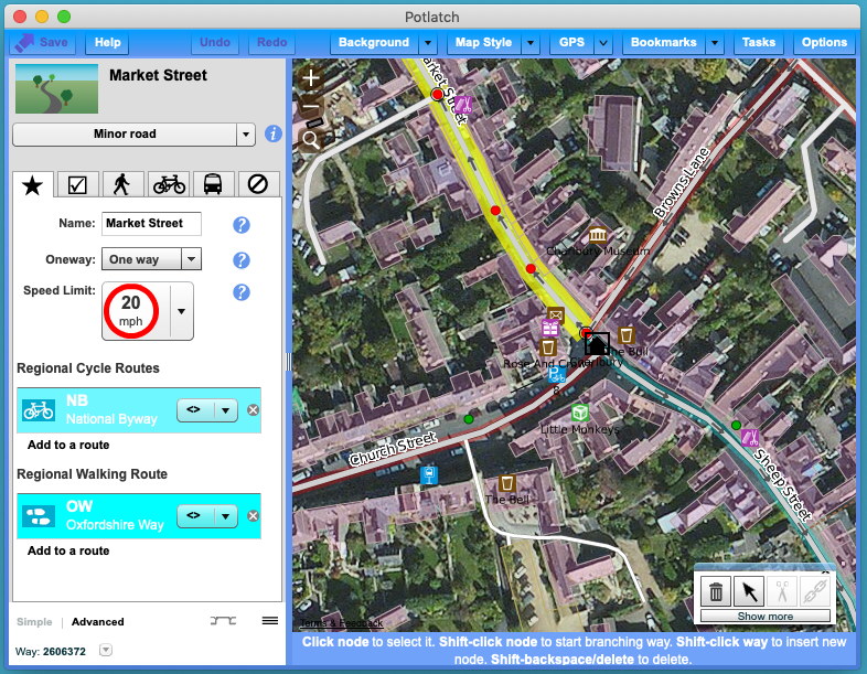
I’m pleased to announce that Potlatch continues to be available, now as a desktop application. You can download it for Mac and Windows at

https://www.systemed.net/potlatch/

Potlatch 3 screenshot

Potlatch 3 includes OAuth login, support for Remote Control, and other features to ease desktop editing. Other new features include support for Overpass API queries in the Tasks palette, and there’s some exciting stuff to come soon… but more of that in due course. As yet we haven’t found a way of reliably running it on Linux but investigations continue.

Potlatch is of course open source. You can get the source and report issues at https://github.com/systemed/potlatch3.

Thank you to the OpenStreetMap Foundation for supporting this work and to Potlatch’s many users for their edits.

Location: Potlatch, Mason County, Washington, 98548, United States

Over the past months, I have spoken to a few different people about the friction that can exist when groups of new contributors engage with OpenStreetMap in areas where there is already existing and active community. Whilst the prompt for writing this diary entry has been recent issues in Panama (between a local YouthMappers chapter and a small group of active local mappers), the content isn’t specific only to that situation and has been informed by multiple people across multiple continents (as well as my own experience).

The issue in itself is also not at all new - I remember if from 2014 when we started the Missing Maps project. What is new is that I now work in HOT’s community team and it’s actually my job to try and work out how to grow the OSM community in a way that respects the past and the future of the project and the community.

You may wonder what the situation in Panama has to do with HOT and I think there are two answers to this.

Firstly, we run the HOT instance of the tasking manager (TM). We see the TM as a community asset and, whilst we don’t originate every project on there (for example, in 2020, HOT originated 17% of all published projects), we do develop and maintain the technology as well as providing the workflows and onboarding for people that want to create and manage specific projects. For example, a majority of YM chapters contribute by mapping through the TM (including the Panama chapter who organised local projects to be set up in collaboration with the global YM team).

Secondly, it is HOT’s mission to radically increase quality local map contributions and contributors from across 94 countries in Africa, Asia and Latin America / Caribbean over the next five years as part of the Audacious project. We need to be good at making sure that new mappers build on what already exists in collaboration with people and communities already actively engaged in the OSM project and that they are welcomed into those same communities.

See full entry

Posted by bo_hot on 31 December 2020 in English. Last updated on 1 January 2021.

To do good, you actually have to do something - Yvon Chouinard

Well today is the day, straightup hackfest. The team will spend the day developing a prototype ready to be tested tomorrow.

We break from the daily structure on this one and the team will break out into smaller groups/pairs to hack together a prototype based on our decision yesterday. This all has to happen in one day, so this is an exercise in effort estimation and making sure we don’t bite of more than we can chew. The goal isn’t to have a refined product, rather something we can use to test our Big Question…

Want us to prototype a solution for your biggest problem? tell us about it here »

away we go

Location: Zetland, Sydney, New South Wales, 2017, Australia
Posted by b-unicycling on 30 December 2020 in English.

The historical society I am a member of does surveys of their main shopping streets about every ten years and I suggested they do one after Covid, because it will affect and has affected the high streets already. They’re not the fastest to realize projects, so I just started already, because OSM will benefit anyway. I’ve done High Street, Kieran Street, parts of Patrick Street and today Rose Inn Street. I’m using a combination of StreetComplete and osmtracker, because StreetComplete doesn’t allow for adding shops etc. But it allows to add housenumbers, which is about time. I’ve noticed that very few shops have their opening hours on the door, so if they’re still open, I usually go in (all masked up, of course) and ask. Sometimes, I have to do that for house numbers as well. I’m looking forward to the streets being less busy (the advantages of lockdown and shops being closed, ironically), because the sidewalks are often very narrow in Kilkenny and surveying takes a lot of time and I don’t like being in the way.

Location: Dukesmeadows, Kilkenny Rural, The Municipal District of Kilkenny City, County Kilkenny, Leinster, R95 P77E, Ireland