海西州飛地一大塊全劃到西藏去了…怎麼沒人改呢…無語…
二編:已得知唐古拉山鎮南部均租借給西藏。
海西州飛地一大塊全劃到西藏去了…怎麼沒人改呢…無語…
二編:已得知唐古拉山鎮南部均租借給西藏。
On the quiet early morning of 18 July 2018, pilgrims from the Mega Arafah Hajj Guidance Group (KBIH Mega Arafah) gathered at the Mega Arafah office near Gedung Sate.

Their first stop was West Java Regional Police headquarters (Mapolda Jabar Gedebage), where pilgrims from across Bandung had assembled.
Я створив невеликий втулок для JOSM з назвою Fillet Tools (fillettools.jar).
Він додає інтерактивний режим для заокруглення кутів ліній, подібний до інструмента «fillet» у CAD-програмах. Основний сценарій використання — контури підʼїзних шляхів та інша точна геометрія, де ручне розміщення кількох точок для заокруглення кута займає багато часу.
Ви можете знайти проєкт у репозиторії GitLab, а завантажити перший тестовий jar-файл — зі сторінки релізу v0.1.0.
Також є дві корисні клавіші-модифікатори:
I made a small JOSM plugin called Fillet Tools (FilletTools.jar).
It adds an interactive mode for rounding corners of ways, similar to a fillet tool in CAD software. The motivation is simple: in the real-world, many objects are not designed with sharp corners. Roads, sidewalks, residential landuse areas, sports fields, running tracks, and other planned infrastructure often have smooth, consistent curves. Mapping these curves by hand usually means placing several nodes one by one, which is slow and often inconsistent. Fillet Tools is an attempt to make this specific editing task easier in JOSM.
You can find the project in the GitLab repository, and download the test JAR from the v0.1.2 release.
How it works:
Quienes se interesan en la región de América Latina saben que somos relativamente jóvenes en la organización de los States of the Map regionales, iniciados en 2015 después de un encuentro fortuito entre personas apasionadas por OpenStreetMap de diferentes partes de la región durante la conferencia Abrelatam en la Cineteca Nacional de la Ciudad de México en 2014 (mismo contexto en el que se decidió crear un chat de Telegram regional, semilla de la comunidad actual). Posterior a este año, se tuvo cierta continuidad hasta la pandemia, por obvias razones, y también por una desmotivación generalizada de la comunidad, que había vivido cierto “renuevo generacional” que había tenido poca interacción con las pasadas, y, claro, también por la precarización general causada por la pandemia, de la que no nos hemos repuesto ante la situación global actual.
– English below
✈️ مطار ذي ناعم – محافظة البيضاء تم إنشاء مطار ذي ناعم عام 1982م، ويُعد المطار الرسمي لمحافظة البيضاء، لما يتمتع به من موقع استراتيجي مهم في قلب المحافظة، إضافة إلى كونه قابلًا للتوسعة والتطوير بما يخدم الاحتياجات المستقبلية للنقل الجوي والتنمية.
تحيات /ابوعاصم العمري
An image: 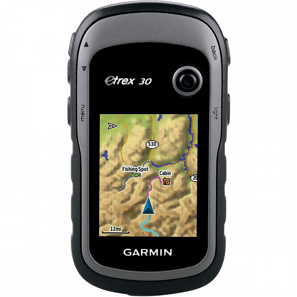
GPS handle (handheld GPS) tidak direkomendasikan untuk digunakan sebagai alat ukur utama Ground Control Point (GCP) pada pemetaan drone atau fotogrametri yang membutuhkan akurasi tinggi. Meskipun GPS handle dapat merekam koordinat, tingkat ketelitiannya hanya dalam hitungan meter (rendah), sedangkan GCP memerlukan ketelitian sentimeter.
Tornadoes are very complex natural disasters involving many shapes and sizes. For a tornado to be on the ground, Look for rotating dust on the ground. The funnel does ## NOT have to touch the ground to be considered a tornado.
The most notable tornado is the May 22, 2011 Joplin EF-5tornado because it was the deadliest tornado in over 70 years. Not even 3 days after, one of the strongest and most notable oklahoma tornadoes happened, May 24, 2011, El Reno - Piedmont EF-5
Hiking has become a popular choice for many outdoor enthusiasts. Especially since the spread of COVID in the early 2020s, hiking has gained widespread popularity. Even people who previously rarely or never went hiking began to see it as a healthy and enjoyable activity during the pandemic.
In response to this continuing trend, an idea emerged: what if we at Kaart invited the OSM contributor community in Bandung to hold a joint activity? Besides serving as a recreational gathering, the event could also become an opportunity to learn about the tagging system related to hiking trails. We first shared this idea in a limited group in Bandung, but it was enthusiastically welcomed by two YouthMappersgroups: UPI YouthMappers and UNJ YouthMappers. Despite the long distance from Jakarta, UNJ YouthMappers showed particularly strong enthusiasm.
The UNJ and UPI YouthMappers community event was successfully organized and ran very well. The program took place smoothly in a series of activities beginning with the arrival of participants from Jakarta on the evening of April 17 and ending with everyone’s departure on the morning of April 19. The number of participants nearly reached the expected target. A total of 17 participants attended, consisting of 2 representatives from Kaart, 10 members from UNJ YouthMappers, and 5 members from UPI YouthMappers.
I got into looking into maps and understanding where everything is. I’m at the point where if I’m at a location I’ve never been before, I will start looking all around me and then using my brain to put everything into OpenStreetMap. I love this website. It’s like a passion project when nothing else sounds fun. Anyway… The point of this Diary is all the changes I added to different locations around the northern parts of Minnesota and Wisconsin. Here is what I wanted to update users past and present on what changes I made.
– 05/09/2026 – Location: 46°44’03.6”N 92°04’46.8”W
I want to thank the community for not deleting @MidwestMapGeek’s building outline. Today, I came here to fix what is the updated version. My goal is to help Semi Drivers and anyone trying to get to this company’s site. You are amazing @MidwestMapGeek <3
– Changes – -Deleted outline of the building -Reworked the new outline for the company -Added another outline for a building next to an existing building -Reworked the rail system so it is clear the the train goes through (underneath) the building -Reworked the road leading to the building site (TPWS) -Added the scale shack that the site has -Finally added a “point” for anyone that is going to TPWS -hours, website, and location are added // note: the address that was given to the company is technically another access point to get inside but from what I heard, you can’t access from there and have to go underneath the bridge near Graymount
– Changeset Number: 182447332 –
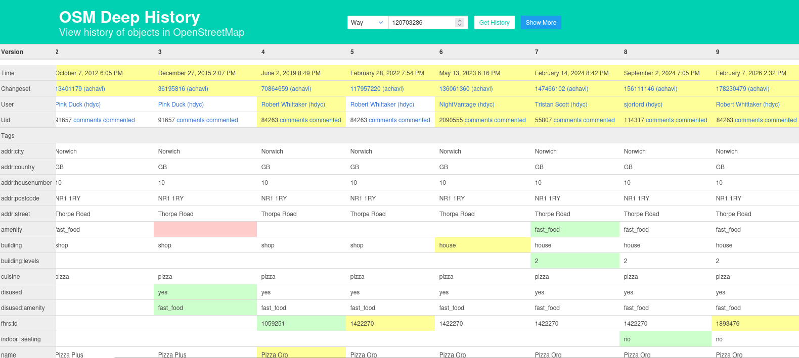
Generally speaking, Lifecycle Prefixes mean that when something is no longer in use, a tag such as amenity gets changed to disused:amenity. That should be straightforward, but sometimes disused=yes creeps in.
This example overpass query for nwr["amenity"="fast_food"]["disused"="yes"]({{bbox}}) finds a couple of examples. In these cases we can have a look at the tag history and (as seen in the picture at the top) notice that the FHRS ID changed recently, and the disused=yes actually corresponded to the name of a different business on the same site (in fact that that one has the full set of such tags: ["amenity"="fast_food"], ["disused:amenity"="fast_food"] (which don’t make sense together) and ["disused"="yes"]. In these cases you can often look through the tag history and see what the current status is supposed to be; if the last changeset comment was “this has now closed” it’s fairly obvious.
Hari Perempuan Internasional diperingati pada 8 Maret tiap tahunnya. Pada peringatan ini pula, banyak hal yang perlu direfleksikan terkait pemenuhan hak-hak perempuan dan kesetaraan gender. Salah satunya, apakah fasilitas umum di perkotaan sudah ramah manusia, khususnya perempuan?
Sejak Maret 2026, saya mengikuti kampanye Jalanin Aja Dulu (JAD) yang diselenggarakan oleh lakunakota di Cekungan Bandung. Pada kampanye tersebut, partisipan didorong untuk berjalan kaki sejauh 2,5 km setiap harinya untuk melatih budaya mobilitas dengan berjalan kaki. Saya memanfaatkan momen ini untuk memetakan dan menilai kondisi infrastruktur pejalan kaki yang saya lalui ke OpenStreetMap (OSM).
Pemetaan saya lakukan sambil berjalan kaki dengan pace antara 9’00” (berarti 9 menit per kilometer) hingga 20’00”, rentang pace yang ditetapkan dalam kampanye JAD. Saya menggunakan aplikasi StreetComplete untuk mendata banyak objek, seperti keberadaan trotoar, penerangan, menambahkan fasilitas umum, dan menambahkan catatan untuk hal-hal yang kompleks. Setelah itu, saya berusaha merapikan pemetaan yang saya lakukan sebelumnya menggunakan desktop iD Editor.
Saya biasanya berjalan kaki di sekitar Jalan Dago, Kota Bandung. Terkadang saya juga berjalan kaki di tempat lain yang familiar, seperti Kota Baru Parahyangan dan Jalan Buah Batu. Tak jarang pula saya memutuskan untuk berjalan kaki di tempat-tempat yang belum pernah saya lalui, seperti Baros di Cimahi atau gang-gang sempit di tengah Kota Bandung untuk mendapatkan sensasi tersendiri. Selain itu, sebagian sesi berjalan kaki saya lakukan antara pukul 6 sore hingga 12 malam, menambah relevansi data yang saya dapat dengan ruang aman perempuan di jalan.
I have been quite interested in being here every once in a while, it actually helps the fact that there’s a map that needs constant updating and can actually do something.
So far, from what I’ve done within my local city of London, Ontario, I finished up:
Im not surprised that theres alot more for me as an individual to explore, nothing much and thats just all.
Silos. Map ‘em. As many as you can. Lovely round, tall silos. Almost never singular. Search for them in farmyards, along railroads. Bonus points for mapping the elevator, truck scales, other assorted buildings and even adding operator.
I love OSM being first. So I went straight out to take GPS trace of new roundabout on our town’s bypass, almost as soon as bypass re-opened.
Probably need to go back and do a bit more work on the exits, but at least it is there!
Today marks three years since I joined the OpenStreetMap community in May 2023. I am posting this diary entry at the exact time I published my first changeset, which I still remember clearly for its simple message: “add more data.”
It’s a straightforward phrase, but over these three years, it’s really shaped my journey as a mapper. What began as a tiny contribution has blossomed into a deep commitment to mapping my area in as much detail as possible.
Right now, I’m focused on two main goals for our region:
Power Grid: I’m mapping every single power line in Tulcea County, from the high voltage transmission lines to the medium and low voltage lines which provide power to every town and village.
Improving Every Town: Besides the infrastructure, I aim to enhance the data for every town in Tulcea County. This involves cleaning up geometry, adding missing POIs, and making sure the map accurately reflects our local communities.
Once I’ve improved every town in Tulcea County and wrapped up the power grid, I intend to shift from regional to national efforts. My aim is to take what I’ve learned here in Tulcea and apply it to bigger projects all over Romania.
There’s a lot to tackle, but as I’ve realized over these three years, the best way to map a country is one node at a time. The upcoming changesets will make OpenStreetMap one of the most accurate maps of Tulcea, providing a level of detail that other commercial map services simply cannot match. I can’t wait to see the map evolve even further.
Removed Plateau Peak Trail. During SAR search (Dec 30) it was discovered the trail was no longer visible on the ground. Parallel trail still visible and provided access to Plateau Peak as verified by GPS.
So here are my experiences in installing Panoramax instance OSM-HR. I’ve made this from notes taken at a time, so hopefully I did not miss too much. Let me know if I did.
There are several ways to install, and I’ve decided to go with docker compose, and with regular OSM Oauth2 login.
We bumped into few issues during the deployment, but we reported them at appropriate repos, and they were fixed so nobody should be bothered by them anymore. Please do the same if you bump into some of your own!
So mostly I followed official instructions here: https://docs.panoramax.fr/backend/install/tutorials/running_docker_osm_auth/
with some preparation first as outlined in: https://forum.geocommuns.fr/t/deploying-a-panoramax-instance-the-pre-flight-check-list/1892
and info about storage needs: https://forum.geocommuns.fr/t/storage-needs-for-a-panoramax-instance/3205
First actual hard step was getting the appropriate hardware and place to host it; see that pre-flight check list for other things like checking the law etc.
http://openit.hr/ kindly donated the hardware, and https://carnet.hr/ the place and Internet to host it. Much thanks to them!
We got quite a beast: 4U Super-Micro cse-847 server with 2 * Xeon E5-2680v2 (40 CPU threads @ 2.80GHz), 256 GB DDR3 RAM, 2x1TB SATA SSD, and 34x3TB SAS HDD (54 TB of usable HDD space after RAID6 partitioning), Nvidia Tesla P4
You can get with (much) lower specs, depending on your needs. But we have a good-hearted sponsor so yay!
So firstly, I went to osm.org/, logged in, clicked on menu / “My account” / “Oauth 2 Applications” / “Register new application” and created Oauth2 application as described on: https://docs.panoramax.fr/backend/install/tutorials/running_docker_osm_auth/#creating-our-osm-oauth2-client
“Name” was set to Panoramax HR and “Redirect URIs” to https://panoramax.osm-hr.org/api/auth/redirect
this is very intriguing I will try to keep up to date.


