OpenStreetMap logo OpenStreetMap

Users' Diaries

Recent diary entries

Posted by Raquel Dezidério Souto on 12 May 2026 in Portuguese (Português). Last updated on 14 May 2026.

– English below

✨ CICLO DE OFICINAS OPENSTREETMAP 2026 PROMOVIDO PELA IVIDES DATA® COMEÇA COM PARTICIPANTES DE PAÍSES LUSÓFONOS


No dia 08 de maio de 2026, iniciamos o Ciclo de Oficinas OpenStreetMap 2026, com participantes de países lusófonos e grande adesão em território brasileiro. Agradecemos a todos que se interessaram em realizar esta formação!

imagem uMap

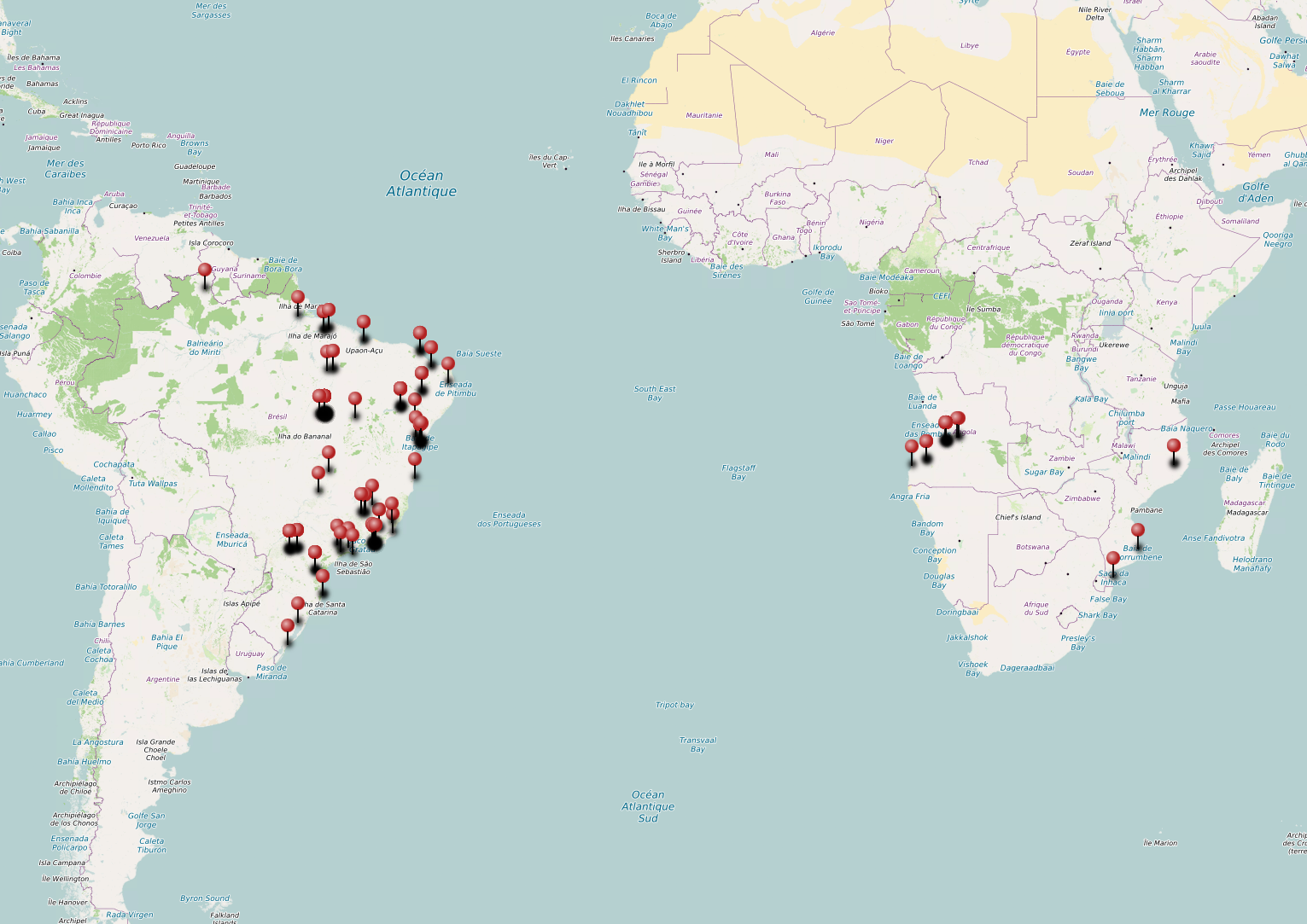
Imagem capturada: Mapa exportado do uMap, com a geolocalização das cidades dos participantes, conforme dados informados por eles mesmos no formulário de inscrição. Dados do mapa de fundo (c) 2026 Contribuidores do OpenStreetMap.


See full entry

Location: Recreio dos Bandeirantes, Rio de Janeiro, Região Sudeste, Brasil

✈️ مطار ذي ناعم – محافظة البيضاء تم إنشاء مطار ذي ناعم عام 1982م، ويُعد المطار الرسمي لمحافظة البيضاء، لما يتمتع به من موقع استراتيجي مهم في قلب المحافظة، إضافة إلى كونه قابلًا للتوسعة والتطوير بما يخدم الاحتياجات المستقبلية للنقل الجوي والتنمية.

تحيات /ابوعاصم العمري

Location: الحماطي, مديرية ذي ناعم, محافظة البيضاء, اليمن

An image: gras

GPS handle (handheld GPS) tidak direkomendasikan untuk digunakan sebagai alat ukur utama Ground Control Point (GCP) pada pemetaan drone atau fotogrametri yang membutuhkan akurasi tinggi. Meskipun GPS handle dapat merekam koordinat, tingkat ketelitiannya hanya dalam hitungan meter (rendah), sedangkan GCP memerlukan ketelitian sentimeter.

Mengapa GPS Handle Kurang Tepat untuk GCP?

  • Akurasi Rendah: GPS handheld (seperti Garmin seri 64/66) menghasilkan kesalahan posisi hingga 1-5 meter, yang akan merusak hasil akurasi peta foto udara.
  • Standar Pemetaan: Pengukuran GCP wajib menggunakan GPS Geodetik/GNSS (RTK/PPK) untuk mencapai ketelitian sentimeter.

Kapan GPS Handle Bisa Digunakan?

  • Pemetaan Skala Kecil/Tingkat Akurasi Rendah: Jika pemetaan hanya untuk visualisasi umum dan tidak membutuhkan akurasi geometris yang ketat.
  • Titik Bantu: Sebagai titik acuan awal, namun hasil foto udara tetap memerlukan koreksi manual yang intensif.
Rekomendasi Alat:

See full entry

Posted by void_aep on 11 May 2026 in English.

Tornadoes

Tornadoes are very complex natural disasters involving many shapes and sizes. For a tornado to be on the ground, Look for rotating dust on the ground. The funnel does ## NOT have to touch the ground to be considered a tornado.

Notable Tornadoes

The most notable tornado is the May 22, 2011 Joplin EF-5tornado because it was the deadliest tornado in over 70 years. Not even 3 days after, one of the strongest and most notable oklahoma tornadoes happened, May 24, 2011, El Reno - Piedmont EF-5

Hiking has become a popular choice for many outdoor enthusiasts. Especially since the spread of COVID in the early 2020s, hiking has gained widespread popularity. Even people who previously rarely or never went hiking began to see it as a healthy and enjoyable activity during the pandemic.

In response to this continuing trend, an idea emerged: what if we at Kaart invited the OSM contributor community in Bandung to hold a joint activity? Besides serving as a recreational gathering, the event could also become an opportunity to learn about the tagging system related to hiking trails. We first shared this idea in a limited group in Bandung, but it was enthusiastically welcomed by two YouthMappersgroups: UPI YouthMappers and UNJ YouthMappers. Despite the long distance from Jakarta, UNJ YouthMappers showed particularly strong enthusiasm.

The UNJ and UPI YouthMappers community event was successfully organized and ran very well. The program took place smoothly in a series of activities beginning with the arrival of participants from Jakarta on the evening of April 17 and ending with everyone’s departure on the morning of April 19. The number of participants nearly reached the expected target. A total of 17 participants attended, consisting of 2 representatives from Kaart, 10 members from UNJ YouthMappers, and 5 members from UPI YouthMappers.

See full entry

Location: Sukawana, Cisarua, West Bandung, West Java, Java, 40551, Indonesia
Posted by kaivessel on 10 May 2026 in English.

Twin Ports Warehouse & Storage

I got into looking into maps and understanding where everything is. I’m at the point where if I’m at a location I’ve never been before, I will start looking all around me and then using my brain to put everything into OpenStreetMap. I love this website. It’s like a passion project when nothing else sounds fun. Anyway… The point of this Diary is all the changes I added to different locations around the northern parts of Minnesota and Wisconsin. Here is what I wanted to update users past and present on what changes I made.

– 05/09/2026 – Location: 46°44’03.6”N 92°04’46.8”W

I want to thank the community for not deleting @MidwestMapGeek’s building outline. Today, I came here to fix what is the updated version. My goal is to help Semi Drivers and anyone trying to get to this company’s site. You are amazing @MidwestMapGeek <3

  • Used Bing Maps Aerial to redraw buildings

– Changes – -Deleted outline of the building -Reworked the new outline for the company -Added another outline for a building next to an existing building -Reworked the rail system so it is clear the the train goes through (underneath) the building -Reworked the road leading to the building site (TPWS) -Added the scale shack that the site has -Finally added a “point” for anyone that is going to TPWS -hours, website, and location are added // note: the address that was given to the company is technically another access point to get inside but from what I heard, you can’t access from there and have to go underneath the bridge near Graymount

– Changeset Number: 182447332 –

How tags have changed on one way

Generally speaking, Lifecycle Prefixes mean that when something is no longer in use, a tag such as amenity gets changed to disused:amenity. That should be straightforward, but sometimes disused=yes creeps in.

This example overpass query for nwr["amenity"="fast_food"]["disused"="yes"]({{bbox}}) finds a couple of examples. In these cases we can have a look at the tag history and (as seen in the picture at the top) notice that the FHRS ID changed recently, and the disused=yes actually corresponded to the name of a different business on the same site (in fact that that one has the full set of such tags: ["amenity"="fast_food"], ["disused:amenity"="fast_food"] (which don’t make sense together) and ["disused"="yes"]. In these cases you can often look through the tag history and see what the current status is supposed to be; if the last changeset comment was “this has now closed” it’s fairly obvious.

See full entry

Location: Lodge House, Stonegrave, North Yorkshire, York and North Yorkshire, England, YO62 4LL, United Kingdom

Hari Perempuan Internasional diperingati pada 8 Maret tiap tahunnya. Pada peringatan ini pula, banyak hal yang perlu direfleksikan terkait pemenuhan hak-hak perempuan dan kesetaraan gender. Salah satunya, apakah fasilitas umum di perkotaan sudah ramah manusia, khususnya perempuan?

Sejak Maret 2026, saya mengikuti kampanye Jalanin Aja Dulu (JAD) yang diselenggarakan oleh lakunakota di Cekungan Bandung. Pada kampanye tersebut, partisipan didorong untuk berjalan kaki sejauh 2,5 km setiap harinya untuk melatih budaya mobilitas dengan berjalan kaki. Saya memanfaatkan momen ini untuk memetakan dan menilai kondisi infrastruktur pejalan kaki yang saya lalui ke OpenStreetMap (OSM).

Metode

Pemetaan saya lakukan sambil berjalan kaki dengan pace antara 9’00” (berarti 9 menit per kilometer) hingga 20’00”, rentang pace yang ditetapkan dalam kampanye JAD. Saya menggunakan aplikasi StreetComplete untuk mendata banyak objek, seperti keberadaan trotoar, penerangan, menambahkan fasilitas umum, dan menambahkan catatan untuk hal-hal yang kompleks. Setelah itu, saya berusaha merapikan pemetaan yang saya lakukan sebelumnya menggunakan desktop iD Editor.

Saya biasanya berjalan kaki di sekitar Jalan Dago, Kota Bandung. Terkadang saya juga berjalan kaki di tempat lain yang familiar, seperti Kota Baru Parahyangan dan Jalan Buah Batu. Tak jarang pula saya memutuskan untuk berjalan kaki di tempat-tempat yang belum pernah saya lalui, seperti Baros di Cimahi atau gang-gang sempit di tengah Kota Bandung untuk mendapatkan sensasi tersendiri. Selain itu, sebagian sesi berjalan kaki saya lakukan antara pukul 6 sore hingga 12 malam, menambah relevansi data yang saya dapat dengan ruang aman perempuan di jalan.

Keberadaan trotoar

See full entry

Location: Lebak Gede, Coblong, Kota Bandung, Jawa Barat, Jawa, Indonesia

Welcome to my first entry in OSM.

I have been quite interested in being here every once in a while, it actually helps the fact that there’s a map that needs constant updating and can actually do something.

So far, from what I’ve done within my local city of London, Ontario, I finished up:

  1. New Plaza at Fanshawe/Highbury
  2. Bus routes
  3. Road classification
  4. Fixing of OSM notes
  5. Coveted new developments at the South and West sides of the city.

Im not surprised that theres alot more for me as an individual to explore, nothing much and thats just all.

Location: London, Southwestern Ontario, Ontario, Canada

I love OSM being first. So I went straight out to take GPS trace of new roundabout on our town’s bypass, almost as soon as bypass re-opened.

Probably need to go back and do a bit more work on the exits, but at least it is there!

osm.org/changeset/182400633

Location: Chetwynd Aston and Woodcote, Telford and Wrekin, England, United Kingdom
Posted by 00-sq on 8 May 2026 in English.

Today marks three years since I joined the OpenStreetMap community in May 2023. I am posting this diary entry at the exact time I published my first changeset, which I still remember clearly for its simple message: “add more data.”

It’s a straightforward phrase, but over these three years, it’s really shaped my journey as a mapper. What began as a tiny contribution has blossomed into a deep commitment to mapping my area in as much detail as possible.

Main Objectives

Right now, I’m focused on two main goals for our region:

  • Power Grid: I’m mapping every single power line in Tulcea County, from the high voltage transmission lines to the medium and low voltage lines which provide power to every town and village.

  • Improving Every Town: Besides the infrastructure, I aim to enhance the data for every town in Tulcea County. This involves cleaning up geometry, adding missing POIs, and making sure the map accurately reflects our local communities.

Once I’ve improved every town in Tulcea County and wrapped up the power grid, I intend to shift from regional to national efforts. My aim is to take what I’ve learned here in Tulcea and apply it to bigger projects all over Romania.

There’s a lot to tackle, but as I’ve realized over these three years, the best way to map a country is one node at a time. The upcoming changesets will make OpenStreetMap one of the most accurate maps of Tulcea, providing a level of detail that other commercial map services simply cannot match. I can’t wait to see the map evolve even further.

Posted by Matija Nalis on 7 May 2026 in English. Last updated on 10 May 2026.

So here are my experiences in installing Panoramax instance OSM-HR. I’ve made this from notes taken at a time, so hopefully I did not miss too much. Let me know if I did.

There are several ways to install, and I’ve decided to go with docker compose, and with regular OSM Oauth2 login.

We bumped into few issues during the deployment, but we reported them at appropriate repos, and they were fixed so nobody should be bothered by them anymore. Please do the same if you bump into some of your own!

So mostly I followed official instructions here: https://docs.panoramax.fr/backend/install/tutorials/running_docker_osm_auth/

with some preparation first as outlined in: https://forum.geocommuns.fr/t/deploying-a-panoramax-instance-the-pre-flight-check-list/1892

and info about storage needs: https://forum.geocommuns.fr/t/storage-needs-for-a-panoramax-instance/3205

Hardware

First actual hard step was getting the appropriate hardware and place to host it; see that pre-flight check list for other things like checking the law etc.

http://openit.hr/ kindly donated the hardware, and https://carnet.hr/ the place and Internet to host it. Much thanks to them!

We got quite a beast: 4U Super-Micro cse-847 server with 2 * Xeon E5-2680v2 (40 CPU threads @ 2.80GHz), 256 GB DDR3 RAM, 2x1TB SATA SSD, and 34x3TB SAS HDD (54 TB of usable HDD space after RAID6 partitioning), Nvidia Tesla P4

You can get with (much) lower specs, depending on your needs. But we have a good-hearted sponsor so yay!

Creating Oauth2 app

So firstly, I went to osm.org/, logged in, clicked on menu / “My account” / “Oauth 2 Applications” / “Register new application” and created Oauth2 application as described on: https://docs.panoramax.fr/backend/install/tutorials/running_docker_osm_auth/#creating-our-osm-oauth2-client

“Name” was set to Panoramax HR and “Redirect URIs” to https://panoramax.osm-hr.org/api/auth/redirect

See full entry

When I first arrived at DTU, I was surprised to discover that the map quality was largely inferior to the one back in my home country, France, and was lacking a lot of details, the most crucial being emergency-related appliances and infrastructure.

I would have expected a leading engineering university to have correct, if not excellent, mapping across its campuses, but seemingly that is not the case. I was a bit disappointed because if Denmark values inclusive design a lot, at least on paper, there is very little activity to make these accessible infrastructures easily reachable by their main targets. I guess full support for these features might also be lacking across the variety of apps using OSM data (without considering that these apps are not used by the majority of people), but yeah, a bit of a disappointment here.

So I randomly started mapping around DTU campus, sometimes raising awareness among people around me, sometimes being told to “get a life” (jokingly), but in my opinion, volunteering for something collaborative, be it a charity or an online collaborative map, adds a lot of value to one’s life. You don’t do things for yourself only. Okay, it might be a bit addictive at some point, and you might make changes that are so niche that no one cares besides yourself, but hey, the whole point of collaborative initiatives is also to embrace individual particularities, not to merge them into a bland and vague thing. By looking at the map in different places, you can notice tiny subtleties and tiny additions that show people cared. Even 11 years ago, people cared. Who knows, maybe this contributor passed away since then? Nevertheless, their work is still there and will continue to be refined further. And that is truly beautiful, in my opinion.

That’s all for today. See you later, maybe! 💚

~ Louis

Location: Ravnholm, Lundtofte, Kongens Lyngby, Lyngby-Taarbæk Municipality, Capital Region of Denmark, 2850, Denmark

Making the Map of India Even More Accurate! 🇮🇳📍

I am proud to share that I have successfully completed 100% of TomTom’s project: “India – POIs Located Not on Buildings.”

The primary objective of this project was to correct Points of Interest (POIs) that were not situated within the accurate footprints of buildings. An accurate map not only enhances navigation but is also absolutely essential for emergency services and local businesses.

Project Highlights:

Mission: Data Improvements

Total Contribution: Successfully fixed 631 out of 734 tasks.

Status: 100% Complete.

It has been a fantastic experience collaborating with the OpenStreetMap (OSM) community to make the map even more reliable.

Mapping isn’t just about finding routes; it’s about helping the world. 🌍📍

I am proud to contribute as a volunteer with United Nations Mappers. I recently achieved Level 5 (Off the Charts). This journey is not merely about statistics, but about reaching out to the communities that need assistance the most.

My Mapping So Far:

Total Swipes: 562+ (For data accuracy)

Total Area: 87 sq. km (Mapped territory)

Projects: Contributed to 9 humanitarian missions

Supported Entities: 2 major organizations

As a volunteer, every swipe I make and every kilometer I map helps facilitate relief operations during times of crisis. 💪

Alright, after successfully updating the boundaries in Bali, now, I’m shifting my focus further east across the Lombok Strait. Next stop: Lombok Island.

For those who don’t know, Lombok is a gem in the Lesser Sunda Islands, famous for the Mandalika International Circuit and its world-class surf breaks. It’s a new major tourist hub that definitely deserves some love on the map. I’ve already spent some time mapping the natural=* and landuse=* in the smaller islands.


Baiklah, setelah berhasil mengupdate batas wilayah di Bali, kini saya alihkan fokus saya ke arah timur melintasi Selat Lombok. Selanjutnya: Pulau Lombok.

Bagi yang belum tahu, Lombok adalah permata di Kepulauan Sunda Kecil, terkenal dengan Sirkuit Internasional Mandalika dan ombak selancar kelas dunia. Wilayah ini bisa jadi pusat wisata baru yang layak mendapat perhatian di peta. Sebelumnya, saya telah memetakan natural=* dan landuse=* di pulau-pulau kecilnya.

Location: Lombok Utara, West Nusa Tenggara, Lesser Sunda Islands, Indonesia