 OpenStreetMap

The areas I mapped are familiar to me, so I was able to add new things that haven’t been marked on OpenStreetMap before. The most important thing about OpenStreetMap, to me at least, is how much contribution is needed to keep everything accurate and up to date. There were some edits in that area that were made 15 years ago, some that haven’t been modified to accurately display the area (under LuLu’s Variety, the block of houses is labelled as a park 15 years ago, when it isn’t a park now). The most challenge I had while editing was trying to accurately name certain buildings. For example, Itec Equipment is a building material supply store, but there weren’t any labels like “Supply Store” or “Building Supply Store”; the best I could label it with was “Rural Supplies Store, but I’m not sure if that is accurate.
Users' Diaries
Recent diary entries
For this OpenStreetMap activity I focused on adding and improving features in an area I am familar with. I contributed information based on places I know, such as my University campus, which made the mapping process both meaningful and interesting to me. I think it is very important to share accurate and local information in OSM, because small details can make a big difference. I also noticed that some information around my area is outdated or incomplete, so in the future I would like to contribute more.
Paused due to seasonal work. I’ll get back to this at some point January.
I seem to have started on the questionable task of adding all the bus routes in Halifax.
I’ve been grabbing the route description from the Halifax Transit website, creating the route relations via Id and then adding to the relation with OSM Simple Route Editor. (I’d prefer to use OSM Relatify, but it seems to take a while to notice that the relation has been created or is having some other issue.) I have been using Relatify to verify that the route is correctly ordered and connected. I have also used the sort feature in JOSM “PT Assistant” plugin to deal with grumpy route alignment.
I have been doing inbound and outbound legs of the bus route as separate routes to avoid the complications from using the same way twice. In the case of the 1, they were already split like that with a master route that joined the two which seems rather elegant. But, it may be worth seeing if there is a way to join the halves together after the fact.
Here’s the overpass-turbo query I cobbled together to find current OSM routes (it mostly worked):
[out:json][timeout:25];
// gather results
(
  relation["type"="route"]["route"="bus"]["network:wikidata"="Q14875719"]({{bbox}});
  relation["type"="route"]["route"="bus"]["operator"="Halifax Regional Municipality"]({{bbox}});
  relation["type"="route"]["route"="bus"]["network"="Halifax Transit"]({{bbox}});
);
// print results
out meta geom;
So far I have found these routes either in OSM or via the current list of route descriptions:
Ich suche gerne erstmal in blogs, aber hier geht es leider nicht, oder ich weiß nicht, wie. Eigentlich bin ich über die App “nora” darüber gefallen, daß eine Straße mit PLZ einem Ortsteil zugeordnet wurde, aber nicht dem Hauptort, wo diese Straße wirklich ist. Wie kann man so etwas korrigieren ?
Mit +++ gekennzeichnete Einträge basieren auf von mir programmierten Erweiterungen. Diese werden regelmäßig aktualisiert; im Kopf dieser Seite wird der Zeitstempel der letzten Aktualisierung angezeigt.
-
+++ OpenStreetMap-Wiki DE:How to map a [A..Z]
Aus dem OSM-Wiki DE:How to map a wird jede Seite des alphabetischen Registers [A..Z] ausgewertet; alle Attribute (EN: tags) werden auf einer Seite gelistet, ein Suchfeld erlaubt die Filterung auf Teilstring-Filter.

Não gosto muito de falar em público ou coisa assim mas me deu vontade então vou falar coisas
Algo que eu percebi é que no openstreetmap aparecem as localidades como Jurerê, Campeche, Lagoa, etc… mesmo elas não tendo fronteiras certas, e também que tem um monte de distrito que não tá no mapa Mas agora começaram a oficialização dos bairros aqui e eu acho isso muito bom mas agora eu não sei quem vai atualizar pq sem contar eu eu só vi tipo 1 ou 2 pessoas aqui editando Enfim só isso

Some news and visions about topic focused contribution monitoring capabilities of Podoma software
Podoma platform
For more than 6 years, former ProjetDuMois platform now Podoma was used to plan, encourage and monitor “Projects of the month” by French community (and some other countries too). It has been a significant progress for people responsible of those very short projects as it has freed us from the hassle of counting changesets and provides a mappers-friendly customized editor.


出于个人的隐私考虑,本人的 OpenStreetMap 账户的用户名使用化名,敬请谅解。
简介&来意
我是一名陕西省咸阳市的中学生,在探索开源软件的过程中遇到了 Organic Maps、CoMaps 和 OsmAnd~,并认识了 OpenStreetMap。由于对开源软件的热爱,以及发现 OpenStreetMap 对中国大陆的小城市(包括我居住的城市)的数据支持不够完善,因此想做出一些贡献,用这种方式帮助自己身边的人以及需要的人(虽然周围的人没有一个知道 OpenStreetMap,但是万一他们哪一天需要呢)
一直以来,坐标系统的不一致导致 Google 地图和其他海外地图在中国大陆的卫星影像和人工标注的道路信息差了上百米,国内的地图软件对国外的数据支持也有限,更重要的是国内外主流的地图产品出于商业考虑不向公众共享地图数据,OpenStreetMap 在这一点上无疑是很好的开源替代品。但其在中国大陆(在国外也可能符合这个规律)的地图数据的详细程度大致与这个地区的经济发展状况成正比关系(正常,商业地图公司的员工开车全国跑,地图数据也要详细的多),这容易让人误解:某个地方除了道路什么也没有。
编辑地图只是出于我对开源软件和开放数据的热爱,而且也不是我的正事,因此我每天不会花太多时间在这件事上。
事件
在 2025 年 10 月 29 日,我收到了贡献者 booktiger 发送的一封欢迎消息,并且阅读并了解了中国的法律情况和编辑指南(说实话我只是想完善一下居民区建筑信息以及店铺信息,我连监狱都不想往上画,更不要说国家机密了),也阅读了他参与的一些讨论(比如 397559)。
本人对政治并不感兴趣,但这并不意味着本人没有一点政治常识。对于台湾问题,我很庆幸 OpenStreetMap 上没有标注国界线,这避免了许多潜在的争议(虽然一些人将水陆分界线当成了国界线并且发表自己的意见,比如 395824)。但是如果你因为 OpenStreetMap 没有给“台湾”后面加“省”感到特别生气,也可以在网络上发表自己的意见。我绝不会干涉任何一方的言论自由,而且也不会修改台湾(省)本地的任何信息。

這篇是拖了一段時間的參與心得,先從比較有官方色彩的開放街圖基金會的相關記錄與討論開始,再來比較個人的交流與觀察。
大會第三天在閉幕式前的 OSMF 時段,由具備理事身份的人座談。OSMF理事長談到一些花費是這麼說的,大家覺得努力募款增加捐款數字,但目前很多幫助來自業者服務捐贈,如CDN、Bing衛星圖、伺服器等,如果任何業者決定中止捐增,會導致 OSMF 有很嚴重的財務缺口。而圖客參與畫地圖才能一直維持地圖的活力,所以社群經營也是重要的挑戰。理事Otris提到,他們目前重點是讓硬體設備能支援未來的需求,很努力進行開發與硬體架構設備。
OSM Award Brandon 被提名,然後他們自己不知道,他開完笑說知道他被提名還可以拉一些票,再來是多位獲獎者不在現場,需要由人代領。
https://awards.openstreetmap.org/
HOT 主力的大會
這次以HOT Asia Pacific Map Guru身份參與State of the Map 2025大會,不只是講者的身份,或是地方社群組織者,還有HOT身份,有點汗顏台灣不是HOT AP優先區域,也不大需要靠OpenStreetMap去成為救災主力圖資。 ## 東亞與南亞社群的聯結 我再次遇到韓國社群的成員,先前在台灣時已經在COSCUP遇到他了,鼓勵南韓的Dong Hwang也可以參與HOT相關訓練課程,其內容都蠻實用的。 從日本社群的古橋大地桑聽到PLATEAU建築資料集的故事,原來背後推動人士瞭解社群,知道怎麼調和彼此關注之處,從而引路社群機制來共同編輯資料集。 與印度社群交流,他們也有類似台灣弄學校資料的整理,由於關注度因素得弄獨立的MediaWiki站,然後他們不同單位有不同代碼,不只需要弄一個代碼。
台灣經驗分享
這次演講題目細數台灣曾經做過的專案,談論將OpenStreetMap與Wikidata彼此連結的經驗。儘管我沒太講工具的部分,但有口頭講在維基媒體生態系的工具生態系較成熟,有運用在Wikidata上的自動表格工具Listeria,監控Wikidata上即時的項目,例如所有台灣的國中小、教會、廟宇、村里行政區之類。目前 OpenStreetMap 上面則沒有太好用的監控維護工具,所以得先在 Wikidata 上確定資料完整,再回過頭檢查 OpenStreetMap 的物件。 近期熟悉OpenRefine是相當好的工具,不過來不及在演講時敘述。OpenRefine是適合做維護工具,有一份相對穩定的有維護的清單,去比對在Wikidata上面是否資料為即時的。
SotM 2025我的講場是第二天一早,我這一軌下一個講場則是烏干達維基人分享自己怎麼做圖書館資料的繪製。他們狀況是並沒有政府維護的圖書館清單,所以得自己依靠社群去收集圖書館基本資訊,如照片、位置等。我的講場與他的講場差別在,有資料集可以用與否,蠻有意思的比較。
另外除了我之外,還有兩位來自台灣的參與者,Proton Maps 的創辦人Brandon 跟他搭同班一早的長榮航班飛來馬尼拉,不過他沒有議程,純來交流。積丹尼是當初破解台電變電箱外數字,被稱為電力座標,其實是 TWD67座標系,則是投稿一場,又有一場lightning talk。跟他聊原來他已經搬到北屯了,不在東勢山區了,聽說原由是他跟鄰居吵架導致他不能住他的農舍了。我還調侃Minh應該常需要檢視積丹尼對 OpenStreetMap、OSM-Carto 接近無理取鬧的討論提議,他是笑笑覺得還好。他現在是 OpenStreetMap Foundation 的工程師,應該也習慣非技術討論,偏向政治的議題討論狀況了。
積丹尼的講場圍繞地址相關議題,用程式方式分析菲律賓一帶地址標示狀況,來檢視其邏輯,他的lightning talk講題偏倡議,則在推廣 grid 的地址系統,認為是最棒的。其實積丹尼的講場應該也可以去投稿學術軌
密切交流

Dan GIS-a (GIS Day) slavi se svake srijede unutar Geography Awareness Week kako bi se istaknula važnost geografskih informacijskih sustava u obrazovanju, industriji i javnom sektoru. Ove godine je to 19.11.2025. i tijekom tog dana organiziraju se demonstracije, radionice i prezentacije koje pokazuju kako GIS pomaže u planiranju grada, upravljanju resursima i donošenju odluka temeljenih na prostoru. OpenStreetMap predstavlja dobar primjer otvorenog, zajednički stvaranog kartografskog projekta koji se često koristi kao izvor podataka u GIS projektima. Korištenje OpenStreetMap podataka i drugih otvorenih podataka u GIS-u potiče transparentnost i suradnju te pomaže bolje razumjeti i upravljati prostorom oko nas. Proširenje GIS Day akcije na OpenStreetMap aktivnost mapiranja tijekom cijelog GIS mjeseca može donijeti dugoročniji učinak, jer se stvaranje i ažuriranje otvorenih podataka prenosi iz jednokratnog događaja u kontinuiranu zajedničku aktivnost. Mi smo se odlučili za sličan pristup, akcija “GIS month osm-hr 112“

Český Krumlov stojí před rozhodnutím, které zdaleka není jen technické. Postavit severní obchvat, anebo hledat jiná řešení dopravní zátěže? Na první pohled jde o jasný krok. Odvést tranzit mimo město. Jenže realita krajiny, chráněných území a členitého terénu ukazuje, že nic takového nejde udělat bez následků. Severní svahy města přecházejí do CHKO Blanský les a přírodního parku Cvičák, kde každý zásah znamená dlouhodobou změnu charakteru krajiny. Městská varianta trasy zas počítá s tunelem, který by stavbu významně prodražil. Ani jedno ale nepovažuji za kvalitní odpověď k výzvě, co s dopravní situací.
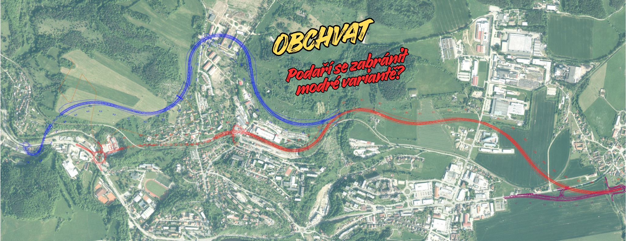 obrázek: Zelení Český Krumlov
Když technika narazí na terén
Bank and ditch
Preliminary
This is a provisional report about a future proposition for specific tags for the following types of banks and ditches:
- bank and ditch barrier
- hedge and ditch barrier
- fossé bordier
- talus
- old way (e.g. Tiense Groef)
About bank and ditch
Bank and ditch or hedge and ditch are man made earthworks in the landscape. All have a historic interest as being the landmark for present and past administrative boundaries. They were used to limit lands, parish, communes, forests, etc.

I’m raising funds to purchase the historic 1:50,000 topographic map series of Eswatini (formerly Swaziland), so I can preserve and share them online as a seamless, zoomable mosaic - free for everyone.
In 2008 I successfully raised £1000 to acquire the equivalent series for Namibia (South West Africa). You can explore that project here: https://namibia-topo.openstreetmap.org.za/
Donate and more information: https://www.gofundme.com/f/purchase-historical-eswatini-topographic-maps

Inspirado pelas estatísticas disponíveis em OSMstats, compilei abaixo a lista de todos os países e territórios atualmente monitorados na plataforma.
Cada nome está vinculado à sua respectiva relação administrativa no OpenStreetMap. A lista dessa forma ajudou muito na tarefa de mapear em todos os países e territórios do OpenStreetmap, conforme relatei aqui.
Esta lista pode ser útil para consultas, análises ou scripts que envolvam os limites administrativos, permitindo acesso direto às relações correspondentes.
Vale aqui uma observação. Entre os 260 nomes apenas 216 correspondem ao admin_level=2, o que é considerado de facto o nível de país. Os outros valores que aparecem são admin_level=3 (17 locais), admin_level=4 (14 locais), admin_level=10 (2 locais) , e 11 locais não possuem a chave admin_level.
Lista de Países e Territórios
Saber onta

This is the story of how the cycling association measured streets in Bruges and got what they wanted - a cycling zone - 5 years after the initial campaign…
The setup
First some belgian road law. One of the peculariaties of Belgian is that we have the concept of a ‘cyclestreet’. This is a street where cars are not allowed to overtake cyclists - one of the tools to make cities more liveable. A cycle zone is similar, except that it is about multiple streets. It needs different traffic signs and is in effect until the “end of cycle zone”-traffic sign.
The cycling association of Bruges wanted a cycling zone in the entire city center. To force this, they devised a plan using a different law. The Belgian road code says that cars are not allowed to overtake a cyclist if the space between a cyclist and the car would be less then 1 meter.
In other words, if the cycling association could prove that most of the streets in Bruges are too small to legally overtake cyclists anyway, that would be a good starting point to force a cycle zone in the city. In practice, it would make the already existing situation more explicit.
Enter OpenStreetMap
As such, the local cyclist association asked me to help them in 2020, in the middle of the corona lockdowns.
I did create a custom version of StreetComplete to ask for the street width (a quest that StreetComplete would officially add about a year later).
And, as such, we got out into the city and, armed with a laser measurement device, took the width of every street in the historic center - a perfect activity to do during the corona lockdowns.
To display the information, I setup a custom map theme on MapComplete (which was quite young as well) to show the widths of the streets.
Using the measured width, parking and sidewalk information, MapComplete can automatically determine which streets are to small to officially overtake a cyclist.
Nn
Há algum tempo estabeleci para mim mesmo um desafio ousado: registrar pelo menos um changeset em cada país/região listada no OpenStreetMap. Eu me baseei na lista oficial do OSMstats, composta por 260 locais ao redor do mundo — e hoje posso dizer que o desafio foi concluído.
O mais interessante dessa jornada foi perceber como o mundo é diverso até no mapa. Em alguns locais, o mapeamento está tão detalhado que foi muito difícil encontrar algo para contribuir. Já em outros… praticamente tudo ainda precisa ser mapeado — sem falar na falta de imagens de boa qualidade para servir de referência.
No fim das contas, foi muito mais do que completar um checklist. Foi uma viagem virtual pelo planeta, enxergando paisagens mapeadas e não mapeadas, contrastes culturais e diferentes níveis de engajamento da comunidade.
E é exatamente isso que torna o OpenStreetMap tão especial. Cada contribuição, por menor que pareça, faz o mundo ficar um pouquinho mais visível.
Agora é pensar no próximo “desafio” 😄 28/10/2025
.png)
Solo tengo que escribir? Aparentemente si

When I was using JOSM tonight, the satellite imagery shown on my screen reminded me of something.

It reminded me of a simulation game I loved playing several years ago : SimCity 4.