Posted by Kitsunderoku>w^ on 10 November 2025 in Spanish (Español).

Por favor escribidme si estáis convencidos de que Getafe necesita editores y uniros a mi para mejorar OpenStreetMap en Madrid.
 OpenStreetMap
Por favor escribidme si estáis convencidos de que Getafe necesita editores y uniros a mi para mejorar OpenStreetMap en Madrid.
I was checking the map in all of the world and i see things that broke my eyes. I never been there but the things i found are don’t common.
I had to add so many things to this place during my courent day in the job. I need someone that with me add to Getafe some things that there aren’t on the map. Please, write me in private to let me now who want to colaborate in this proyect that is name: Lets help Getafe!!!! Let me now who is interesed writting me. I will read your menseges. Bye Kitsunderoku
More recently I find myself addicted to OSM once more after a long hiatus. I guess working in the civil road design space has me interested in capturing features around the streets such as crossings, sidewalks, street furniture and recreation spaces.
I’m shocked by the number of sidewalks I have found that cross a street not as a crossing. I’m fixing these as I find them.
My end goal is to try and resolve as many items from StreetComplete as I can around where I live and work, adding to the accuracy of the overall map model locally.
Da ich Organic Maps am Handy nutze und entdeckt habe, dass manche Informationen oft jahrealt und überholt sind, bearbeite ich nun wieder OSM.
Eine Idee, die ich umsetzen will, ist eine Art Übersichtskarte von öffentlich zugänglichen Pianos und Flügeln. Ich finde es selbst oft sehr reizvoll beim Reisen, wenn man als Musiker ein freistehendes, öffentlich zugängliches Instrument wie ein Klavier entdeckt und darauf spielen darf.
Collaborating to add verified information to OpenStreetMap can significantly improve global navigation and community planning. I am a firm believer that each contribution helps create a more accurate, accessible, and connected world. Together, we can truly make a difference!
LostAlone
Having grown up in the Current River Area there are many same details I was able to add to the map such as small back roads that are mainly used my locals. Additionally one thing I noticed with is that many features where outdates. There where restaurants and stores that closed down years ago and new ones have since opened up in their place. So I updated the map to have the newest data. From using openstreetmap I learned a lot about citizen mapping and the people who live in an area know it the best to map it. But also using a mapping website open to the public comes with risks of inaccuracies. What I found to be challenging was that some houses weren’t properly lined up so it impacted when I tried to add a new house.
… and following on from the previous entry, Maps for Garmin devices at map.atownsend.org.uk now show crossing details too:
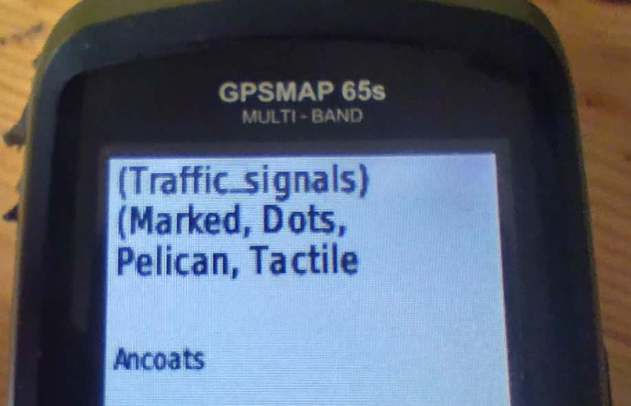
The following tags from the top-level feature are shown:
traffic_signals or crossing
crossing if it adds extra informationcrossing:island, crossing:marked, crossing_ref etc. if they add extra information.tactile_paving and kerb.All of this might be truncated for length (it is here), but the most important information does appear.
خانه محل زندگی
Em locais onde o contraste de cores é bem definido, você pode usar o plugin areaselector para adicionar áreas de forma mais ágil — basta apenas um clique.
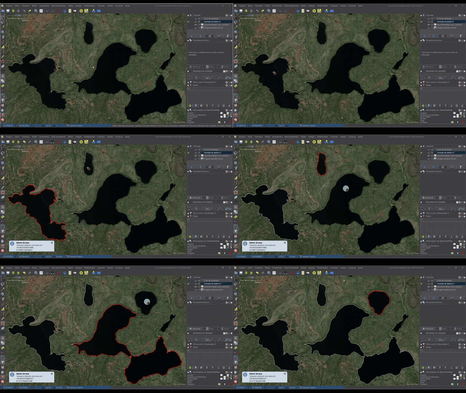
O contorno ficará com uma aparência serrilhada, com ângulos de 90°.
O segundo passo é fazer uma suavização usando o plugin Scripting, com o código disponível aqui.
I am a new editor of OSM, and I thought I would explore the tools and update familiar areas for myself. I added and updated areas in Bronte Creek Provincial Park. The OSM tools made it really easy to add new areas, points of interest, add some walking trails and label everything with accurate details. The park was already mapped with buildings, trails, roads, parking lots and much more. A lot of what I found myself doing was adding newly labelled areas, ex. Cow Barn, Cow Pasture. I am very familiar with BCPP, and now anyone looking to go to the park can have a better idea of what is really there. OMS is very easy to navigate, and I enjoyed using this mapping software. Not only is it a great tool to add for other people to use, but it is also great to see what is really in your surroundings.
Ivan ha pubblicato recentemente una mappa dei CAP fatta da koriander sul gruppo Telegram @OpenStreetMapItalia.
Saltava subito all’occhio che c’erano diversi errori nei dati sorgenti su OSM. Perciò ho iniziato a fare delle query con overpass turbo per trovarli.
La prima cosa che ho fatto è stata quella di fare una query per trovare valori del tag addr:postcode che iniziano con una lettera diversa rispetto all’area geografica in cui si trovano. Ad esempio, in Piemonte, i CAP iniziano tutti con “1”, a eccezione delle province di Novara e del Verbano-Cusio-Ossola.
Ho scoperto che alcuni indirizzi sono stati copiati dal web. Di per sé non è un problema, ma lo diventa se il mappatore non capisce che il POI che sta aggiornando non è quello recuperato su Google e quest’ultimo si trova invece a centinaia di chilometri di distanza. Ad esempio questo, questo e questo.
Poi ho fatto una query che restituisce i CAP sintatticamente errati, ovvero che non sono composti da 5 cifre.
Ho così trovato che molti degli attracchi dei vaporetti a Venezia avevano un CAP (!!). La cosa più strana è che il valore era sempre “30121-30176”.
A guardare bene, però, questo fenomeno non era limitato a Venezia. Continuavo a trovare CAP in questo formato in tutto il Nord-Est e non capivo perché. Tra l’altro il tag “addr:postcode” era stato inserito anche nei posti più assurdi (fermate del vaporetto, monumenti ai caduti, ecc).
Poi ho avuto una illuminazione: il dato è stato copiato da Wikipedia senza alcuna verifica.
Dopo aver analizzato un po’ di changeset ho notato che TUTTI gli edit sono stati fatti con Organic Maps.
Ho quindi scoperto che Organic Maps compila automaticamente il CAP prendendo il dato da Nominatim, che a sua volta lo prende dal tag postal_code.
Tutti questi tag postal_code sono stati aggiunti dallo stesso utente nel 2023 (ovviamente copiandoli da Wikipedia).
Fine storia triste.
I cycle around town a lot and I’d like people to join in. One of the barriers to entry is finding safe routes so I thought I’d try and update the map with the cycle infrastructure as it is built.
I was also pointed at StreetComplete so I’ll log more metadata in my area as I wander about.
Siamo a Pisa, la Fiab ha organizzato un censimento delle rastrelliere presenti in tutto il comune. Attraverso la web-app Ushahidi, dopo aver caricato le rastrelliere già esistenti, sono stati raccolti i dati con l’aiuto di tutti i bikers della città.
Ora abbiamo revisionato tutte le pubblicazioni e scaricati su un file CSV.
Siamo ora pronti per fare un import su OSM.
Se qualcuno ha dei consigli, suggerimenti, e quant’altro si faccia avanti.
Grazie e buon lavoro a tutti.
Ok, my good friend Butterball wanted to pay me a visit from Bree. You all know how he is, super braggy. He told me he just got a brand new iPhone version 1 with 20 KB of RAM. I was like, “Okay, cool, Butterball. We’ll see you. Just don’t be braggy.”
He wrote me a long letter promising me that he wouldn’t be braggy, but then he told me about a problem that he had. He had too many footpaths coming up on his map. He couldn’t find the way easily. Every time he brought up the map, his iPhone crashed. Check out the shire with all of the footpaths!

I told him, “Don’t worry, I’ll just modify his map with a new layer with just roads on it instead of all the other extra crap.”
I was like, Open Street Map is pretty awesome, but they include a lot of stuff in their layers, and then they let you just claw back what you want. I think what we want to do is modify it so we only show the tags that we want, so your map doesn’t crash. Does that sound like a good plan?
🚀 Projeto Mapeia Brasil - Mapeia Brasil Project

O Mapeia Brasil é um projeto que surgiu com a missão de melhorar a qualidade dos dados geográficos no Brasil, com foco na atualização e correção dos nomes das ruas e vias no OpenStreetMap (OSM). A ideia foi originada em 2025, após uma análise comparativa entre os dados do OSM e os dados do IBGE (Instituto Brasileiro de Geografia e Estatística), especificamente do Censo de 2022. Durante esse processo, foi identificado que 13 cidades brasileiras precisavam urgentemente de atualizações nos seus dados de vias. O projeto visa corrigir essas informações para melhorar a navegação, os serviços públicos e facilitar o uso de aplicativos de transporte, compras online e outros serviços essenciais.
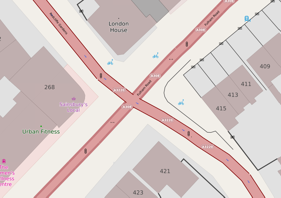
I have a couple of web maps, and they are supposed to show pedestrian crossings. If there’s some crossing infrastructure (for example - zebra stripes, or tactile paving and a lowered kerb) you’re supposed to see a “crossing” icon. If there are traffic signals associated with the crossing, that icon should be replaced with a “traffic signals” one.
Years ago it was straightforward - you’d get a highway=crossing tag on a node on the roadway, and there would be another tag, such as crossing_ref to say what sort of crossing it was. Some crossings (such as pelican, puffin and pegasus) have traffic signals; others (zebra and informal crossings) tend not to.
Unfortunately, it has got a lot more complicated.
Sometimes, the highway tag is crossing;<something> or <something>;crossing. Sometimes that something should be ignored and treated as a crossing.
One of the most important things I learned about mapping with OpenStreetMap is how collaborative and detailed the global mapping community is. Every edit, no matter how small, contributes to a shared, constantly evolving map that supports navigation, humanitarian efforts, and local development. I realized how crucial accuracy and verification are, each feature needs to be placed and tagged correctly so that it’s useful for others. The most challenging part of editing OSM was learning the tagging system and ensuring that my edits followed mapping conventions. I mainly mapped in areas that lacked detailed data. Overall, the experience showed me how open data and collective participation can create powerful geographic resources that benefit communities around the world.
I edited an area where I grew up and frequently return. I chose to focus on some features in this area, as I figured some would be missing or incorrect due to fewer resources to investigate them and their lower priority given the town’s smaller size. I decided to start with elements I knew were recent in the town, such as the opening, closing, or rebranding of businesses. Then I moved into land-use elements, as some areas were assigned to a broader category when a more specific use could be assigned. I updated some other features as well, like microfeatures in Murphy Park and Canada Post mailboxes, but I mainly focused on businesses and updating the elements around them. I learned that, in OSM, you can get a lot more detail on land use in an area, which I thought was a really nice feature. One of the challenges for me was finding the aforementioned resources. If I had not frequented this area, it would be difficult for me to understand what to update or add, as the larger mapping services are also outdated. I foresee this as a challenge with OSM: without someone in a small town committed to making changes, they will slowly lag behind the already slow giants in the industry.


