 OpenStreetMap
.jpeg)
incibey Halil inci
Users' Diaries
Recent diary entries
Posted by 𝘑𝘢𝘧𝘢𝘳 ⇲ 𝘒𝘩𝘰𝘳𝘢𝘴𝘢𝘯𝘪 on 20 September 2024 in Persian (فارسی).
Last updated on 25 June 2026.

Zarrindasht Khorasani
Originality in the Root, Blessing in the Fruit
زریندشت خراسانی مجموعهای خانوادگی و ریشهدار در حوزه کشاورزی، باغداری و دامپروری است که بر پایه میراث نسلها، دانش فنی، مدیریت مستقیم خانواده و بهرهگیری از روشهای نوین کشاورزی شکل گرفته و توسعه یافته است.
این مجموعه با تکیه بر اصالت، تجربه و نگاه بلندمدت به تولید، در زمینه توسعه باغ پسته، کشت محصولات زراعی و استفاده از سیستمهای مکانیزه و بهروز آبیاری فعالیت میکند.
باغ پسته زریندشت که پایهگذاری آن از دهه ۱۳۷۰ آغاز شده، امروز پس از سالها صبر، مراقبت و تلاش، به یکی از ارزشمندترین بخشهای این مجموعه تبدیل شده است.
زریندشت خراسانی، روایتی از پیوند عمیق خاک، آب، آفتاب و همت نسلهایی است که باروری، ماندگاری و برکت را در دل این سرزمین معنا کردهاند.
Holy
Posted by Mariannamukulunga on 19 September 2024 in French (Français).
Last updated on 21 September 2024.

Donner l’opportunité d’aller assister au STATE OF THE MAP ne pas donner à tous les mondes; c’est pourquoi ;je peux dire que je suis l’une des personnes le plus chanceuse d’avoir été sélectionné a la HOT OPEN Summet, la bourse pour assisté au StateoftheMap24. le STATE OF THE MAP était organiser pour la première fois en Afrique, au Kenya, Nairobi et c’était une opportunité en or pour moi de rencontré plusieurs passionner de la cartographie qui partage la même vision avec moi. Quitter la RDC; passant par l’Uganda jusqu’au Kenya, Nairobi… la route était trop longue mais ça valait la peine. Plusieurs leçons apprise, plusieurs méthodologies de la Cartographie, le StateoftheMap a toujours été un moment pas comme les autres car ça ressemble plusieurs personnes dont auparavant on avait l’habitude de parler en ligne ;


Durch eine Website über vier Schulstraßen in Dortmund [1] und mit der Frage im Forum [2] habe ich diese mit dem Tag
traffic_intervention=school_street
versehen.
Zusätzlich habe ich auf einer uMap [3] 17 weitere Schulstraßen eingetragen, die ich im Internet gefunden habe.
Wer ein Foto der Beschilderung hat, kann es mir gerne schicken (oder einen Link teilen). Ich werde es entsprechend ergänzen. Und falls jemand weitere Schulstraßen kennt, freue ich mich über Hinweise oder Kommentare!
[1] Schulstrassen auf dortmund.de
[2] Forum
[3] Karte

It is definitely good knowing how to use field tools to map on specific projects.
There comes experience 😊 regardless of previous teaching on how to use these tools like ODK, Vespucci, Mapsme and others; in the field you definitely have to use your own discretion to relate and adjust to what is given to maintain your nobility at work.

К нему не заростет народная тропа,
Вознесся выше он главою непокорной
Александрийского столпа.
Получилось вот так:
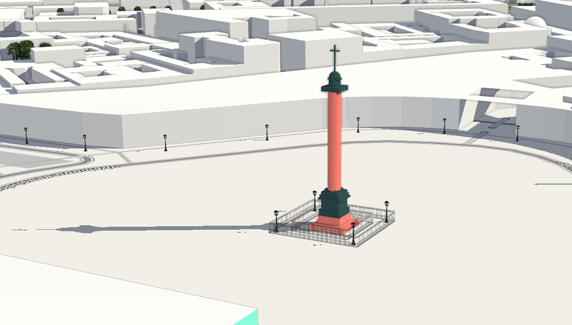
Так же на F4
Моделировать классицистические формы довольно просто, а вот с ангелом всё намного сложнее. Если у кого-то есть лицензионно-чистая модель ангела с Александровской колонны, например для 3д-принтера, милости прошу.
Нет, весь я не умру — душа в заветной лире
Мой прах переживет и тленья убежит —
И славен буду я, доколь в подлунном мире
Жив будет хоть один пиит.
Ну или хотя бы один картограф :)
P.S. Как бы так еще главный штаб переделать, чтобы он был похож на себя?

I became interested in the issue of localizing the map of Ukraine into English and decided to raise it in several forum discussions (first, second, third) to delve into the nuances and find optimal approaches to filling out the name:en tag for objects in Ukraine.
My goal was to understand how to correctly fill in the name:en tag and determine whether it should contain a translation or transliteration. While this may seem like a technical issue, it actually has deep cultural and historical roots, and the answer is not immediately obvious. However, through the discussion, I believe I found a solution and would like to share it in this diary.
Endonyms and exonyms: what are they?
First and foremost, it is important to understand the difference between endonyms and exonyms.
Endonym refers to the name of a geographical object in the language of the people who live in that area. For instance, for the residents of Ukraine, the name of the capital Kyiv is an endonym. Endonyms always reflect the authentic name used by the local population.
Exonym refers to the name for the same geographical object used by people or countries outside that area. Examples of Ukrainian exonyms include Viden for Wien, Niu-York for New York, and Florentsia for Firenze. The Spanish name for the city Lviv is Leópolis, and the German name is Lemberg. Historically, such names were formed quite chaotically, influenced by various linguistic traditions or political processes.

Last week we released Rapid v2.4, the most advanced web-based editor for OpenStreetMap. This release wraps up several months of work, includes numerous bugfixes, and a few notable features:
🈺 Improved Text Localization
Now Rapid can again be localized into different languages. The Rapid Editor project on Transifex allows anyone from the community to translate Rapid.
📷 Improved Handling of Street-level Imagery and Detections
We squashed a bunch of bugs and made many improvements to how Rapid handles street-level imagery, such as Mapillary. Now users can select a detected feature or traffic sign to learn more about it, and Rapid will highlight the imagery that shows that detection, both on the map and in the viewer. This will be especially useful for mapping pedestrian features, such as traffic signs, crosswalks, bike racks, and more.
👩💻 Use Rapid
👉 Bookmark Rapid and make it your editor of choice:
Posted by Sujan Adhikari on 17 September 2024 in English.

Introduction:
Over the past year, I have been working as a backend developer on the Field Mapping and Tasking Manager (FMTM) project for the Humanitarian OpenStreetMap Team (HOT). My role has involved system design, feature development, and bug fixing, all aimed at enhancing the efficiency and usability of field mapping for humanitarian purposes. One of my key contributions has been developing and refining the FMTM Splitter —an algorithm designed to streamline field mapping by dividing map Areas of Interest (AOI) into manageable tasks for mappers.
In this post, I will discuss the workings of the FMTM Splitter, the challenges we’ve overcome, and how OpenStreetMap (OSM) data plays a vital role in making this tool effective for humanitarian efforts.
The FMTM Splitter: Two Key Algorithms
The FMTM Splitter is crucial for breaking down large AOIs into smaller, manageable tasks for field mappers. The goal is to ensure that mappers can efficiently collect and update information without having to cross major obstacles like highways or rivers. This makes the mapping process not only faster but also safer and more convenient for field mappers.
We developed two main algorithms for splitting AOIs:
SplitBySquare:

dear diorey
Didn’t do anything today sadly apart from a few streetcomplete stars
16th of September, 23:27, Poland
Mi ubicación principal de Facebook
Posted by Micheal Kal on 16 September 2024 in English.
Last updated on 25 September 2024.

Well, let me share my experiences at “State of the Map 2024” in Nairobi at the University of Nairobi which I must say was like the coolest place ever for a bunch of map nerds like us to meet. As far as I can tell, it’s the place where all the folks behind OpenStreetMap, get together from all corners of the world to share their experiences, get excited about the mission of making this world more navigable with the help of our maps. It was very much like attending a large family reunion with an attempt at small talk that quickly degenerated into everyone’s passion for Open geospatial data.

Since the beginning of June, I have been working on researching and locating the holy wells of County Kilkenny. I have more or less identified about 213 of them which are described in sources going back at least 90 years (Schools’ Collection etc). In some cases, it is very difficult to locate them, because their location was only given as “in such and such a townland in that person’s field”, and it is very difficult to find out who owned a field 90 years ago.
In addition to that, I have more recently started an oral history project collecting people’s memories and stories about holy wells, patterns (which is a type of originally religious festival in Ireland where people do or did things in a certain pattern around a sacred site usually on the patron saint’s feast day) and other related things. I’m uploading them to Wikimedia and add transcripts, if you’re interested: Category:Oral history about holy wells in County Kilkenny.
What has that to do with mapping, you may ask. Well, apart from locating these holy wells and holy well sites which are protected monuments (and sometimes still water sources), I’m getting local place names from my interviewees as well. Names of roads, cross roads, field names etc which are also not recorded on any map yet, but are frequently still used by locals or were used in the past, so recording them now will help locate things referred to in older sources. Some of these, like Bóthar Chiaráin (Kieran’s Road after St Kieran) potentially go back 1300 years or so.
Posted by Erick tamba on 15 September 2024 in English.

YouthMappers Pre-Event at American Spaces.
The State of the Map (SotM) 2024 in Nairobi started with the most exciting YouthMappers pre-event at American Spaces. It was clear that the conference was going to be full of inspiration and action. Our host Laura was there to welcome YouthMappers early birds from different parts of the world gathered in the venue gearing up for the day’s activities just to prepare for the conference.

Posted by Erick tamba on 15 September 2024 in English.
Location:
Chuo Kikuu, Ubungo, Ubungo Municipal, Dar es-Salaam, Coastal Zone, Tanzania
Posted by wanarejadesa on 15 September 2024 in Indonesian (Bahasa Indonesia).
BATAS DESA WANA REJA DENGAN WANA ARUM RIMBO ULU TEBO
Posted by wanarejadesa on 15 September 2024 in Indonesian (Bahasa Indonesia).
PERBATASAN DESA WANA REJA, RIMBO ULU DENGAN DESA PERINTIS JAYA RIMBO BUJANG
dear dioRey
hi today i basically just solved random notes and added some more farmland in the area i found not much to say
15th of September 2024, 12:12 AM, Poland

STATE OF MAP 2024, Nairobi Kenya -First Time in Africa🌍

You know that classic email that starts with “Congratulations! We are pleased to offer you…”? Well, on July 1st, I got one of those from Hot Open Summit, awarding me a scholarship to attend State of the Map Global in Nairobi! Thanks Hot Open Summit! Let’s stay connected, we’ve got Manila SOTM 2025 coming up! 🫡🫡🙏🤩
First thing I did? Downloading offline maps of Nairobi with OSMAnd and Maps.me , I had to get those OSM maps in my hand, ready to go. I was feeling chill, knowing I was all set for my trip to Nairobi.
From Dar es Salaam to Nairobi, the journey kicked off with 7 of us heading there in one bus. We had a fun group Hawa next to me, Innocent chilling at the far end, Anastazia, Amour, Kombe, and Benedict. I couldn’t wait to get there, and OSMAnd was the trip MVP, keeping us informed like a road-trip soundtrack “Are we there yet?”