 OpenStreetMap

Родина — это не только власть, это страна, в которой мы живём, её земля и её народ!
Users' Diaries
Recent diary entries

Imus Place
As a resident Imus City (Philippines) is names is are find is mapped, was required maps from the developer, has place are in cavite amenities and was damage in bacoor.
Posted by kikihadwiyanti on 6 June 2024 in English.

The Generous Open Mapping-Data Quality Focused
Open mapping is a powerful tool for creating and sharing geographic data in a collaborative and open manner. Its benefits include increased data accuracy, improved data integration, and enhanced data visualization capabilities. However, it also has some limitations that need to be considered, such as data quality and security concerns. Open mapping has been instrumental in various initiatives, such as humanitarian aid, disaster response, and urban planning, and has become a vital resource for many organizations and individuals. While open mapping has many benefits, there are also some limitations to consider:
- Data Quality: Open mapping data may not always be accurate or up-to-date, as it relies on contributions from a community of volunteers.
- Data Integration: Open mapping data may not always be easily integrated with other data sources, as it may use different formats or standards.
- Data Security: Open mapping data may be vulnerable to security risks, as it is publicly available and can be accessed by anyone. Data quality is a critical aspect of open mapping initiatives. By understanding the challenges and implementing best practices, open mapping communities can improve data quality and ensure the accuracy and reliability of the data.
Posted by Carlos Lunna on 6 June 2024 in Brazilian Portuguese (Português do Brasil).
Last updated on 2 July 2024.

Este é o primeiro entre os diários de campo que compõem o caderno de campo da minha pesquisa sobre interações sociotécnicas nos Altos e Córregos da Zona Norte do Recife e sua área contígua em Olinda, cidades localizadas na Região Metropolitana do Recife (RMR). Mais detalhes sobre a pesquisa vocês podem ver na minha tese de doutorado, publicada em https://repositorio.ufpe.br/handle/123456789/48802. Para a tese a delimitação socioespacial foram os Altos e Córregos da Zona Norte do Recife, a parte de Olinda foi agregada depois da tese.
Os diários de campo foram realizados em minhas idas ao território objeto de estudo. Nessas idas sempre registrei o percurso com o aplicativo OSM Tracker. Esses tracks eu coloquei no uMap, esse é o link do track deste diário de campo http://u.osmfr.org/m/1079569/. Embora quase sempre o OSM Tracker seja bastante preciso, nesse caso ele traçou uma linha bastante estranha, que não condiz com o percurso percorrido. Contudo, ele reproduziu as andanças no entorno da Rua Camboriú, local onde concentrei a maioria das informações.

This diary entry is also available as a personal page on the OSM wiki.
Some History of GNIS Imports
GNIS is a database developed by USGS that contains information about the official, standardized names for geographic features in the US.
From 2008 to 2011, there was an effort to import basic data into the US map, including records from GNIS and records from TIGER and NHD that are cross-referenced to GNIS. You can see some of the history of these imports based on the tags they used.
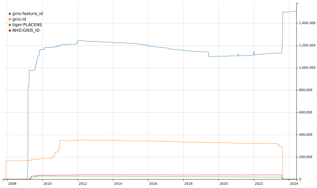
The gnis:feature_id tag was typically used for imports of many types of GNIS records. The gnis:id tag was used for imports of nodes for Populated Places, i.e. place=city, town, village, hamlet, etc. The tiger:PLACENS tag was used for imports of civil boundaries from the US Census Bureau datasets and contained a GNIS Feature ID value. The NHD:GNIS_ID tag was used for imports of waterways and other hydrographic features from the National Hydrography Dataset and also contained a GNIS Feature ID value.
OpenStreetMap is the project that picks where products that are driven by commercial incetives end. One of those areas is mapping the world also with respect to accessibility for people with disabilities. I’d like to talk about OSM for the blind (4).
Full text I’ve posted for the purpose of discussion to:
https://community.openstreetmap.org/t/more-osm-for-visually-impaired/114200

🌟 Calling all designers and creatives! 🎨✨
We’re on the hunt for the perfect logo for #SotMAsia24! 🌏✏️ If you’ve got a knack for design, we want YOU to paint the face of this year’s State of the Map Asia event in Cox’s Bazar, Bangladesh. 🇧🇩🗺️
Check out the details and submit your masterpiece by June 15th, 2024!
Check out the details here: osm.wiki/Call_for_Logo
Let’s make this year’s logo shine! 💫


Today I mapped Përcëllesh which is a tiny village with a population of around 140. Since the village was very small, I expanded my mapping to the surrounding villages, and i also partially mapped the villages Kryezi and Gurrë.
“#100VillagesIn100Days #Day5”

I travel up here regularly to visit relatives. The existing map is obviously auto-generated and not very accurate. In the near future I’ll record all the local roads in the area and correct the OSM data.
Good

I did most editing of the Building and other allied mine infrastructure of this mining site. This Mine site is managed by Harmony Gold Limited of Africa , which I was an employee as a Mine Surveyor .It was the site I worked for 2 months before I left for another job at Simberi Gold Mine in New Ireland Province. I used the Camp maps supplied by National Catering Services(NCS) to populate the Building names in OSM.
Posted by mvogelsteller on 4 June 2024 in German (Deutsch).

Ich bin Mario, ein leidenschaftlicher Reiseblogger, der seit vielen Jahren die Welt erkundet. Seit meiner ersten großen Reise vor über 20 Jahren verlasse ich mich auf OpenStreetMap (OSM), um meine Reiserouten zu planen und meine Erlebnisse mit meinen Lesern zu teilen. OSM hat sich für mich als unverzichtbares Werkzeug erwiesen, das mir hilft, die Welt aus einer einzigartigen Perspektive zu entdecken und meine Leser auf spannende Reisen mitzunehmen.
Die Welt im Detail erkunden
OpenStreetMap (OSM) bietet eine einzigartige Möglichkeit, die Welt in all ihren Facetten zu erkunden. Für Reiseblogger ist diese Plattform ein unverzichtbares Werkzeug, um detaillierte und aktuelle Informationen über ihre Reiseziele zu erhalten. Der offene und kollaborative Charakter von OSM ermöglicht die Erstellung von Karten, die weit über die standardisierten Informationen herkömmlicher Karten hinausgehen. So können individuelle Reiserouten geplant und Orte entdeckt werden, die in kommerziellen Karten oft übersehen werden.
Lokales Wissen nutzen
Einer der größten Vorteile von OpenStreetMap ist das lokale Wissen, das in die Karten einfließt. Reisende, die ihre Erfahrungen teilen, können spezifische Details wie kleine Cafés, versteckte Wanderwege oder interessante Sehenswürdigkeiten hinzufügen. Das macht OSM zu einer lebendigen und ständig wachsenden Ressource, die Reiseblogger nutzen können, um ihren Lesern exklusive Einblicke und Insidertipps zu geben.
Individuelle Karten gestalten
Mit OpenStreetMap können Reiseblogger eigene Karten erstellen und anpassen. Dies ist besonders nützlich, um individuelle Reiserouten zu präsentieren oder spezielle Themenreisen zu illustrieren. Ob es sich um eine kulinarische Stadtrundfahrt oder eine Abenteuerreise in die Natur handelt, OSM bietet die Flexibilität, Karten an die Bedürfnisse und Interessen der Leser anzupassen.
Echtzeit-Updates und Verlässlichkeit
Lapardha e Sipërme seems to just be a point on top of a hill (i will have to figure out if I can get my hands on some data to map the village area correctly.). I figured out the village has some neighborhoods which are located around the hill. I proceeded mapping Muhollarë (Lapardha), Goxhollarë (Lapardha), Gjole (Lapardha), Myrtallarët (Lapardha). This area is filled with greenhouses, but I mapped only some of them. I will try to map the greenhouses another day and focus only on them.
“#100VillagesIn100Days #Day4”
Krajnice mapujem iba na cestách 1., 2. 3. triedy a vedľajších cestách medzi obcami, po ktorých sa pohybujem a ktoré poznám, z pohľadu cyklistu. Nemapujem krajnice v uliciach a bočných cestách v obci, iba ak je to frekventovaná cesta napr. na/cez sídlisko.
Yes alebo Both - krajnica po oboch stranách cesty, dostatočne široká, takže cyklista nezasahuje telom alebo riadidlami do vozovky (jazdného pruhu), vodič pri obiehaní cyklistu nemusí vybočiť a stále má veľký odstup. Ak je krajnica menšia, zadávam aj odhadovanú šírku.
No - krajnica nie je, alebo je taká úzka, že cyklista jazdí po čiare krajnice alebo po pravom okraji vozovky (v jazdnom pruhu). Môže jazdiť aj vpravo od čiary krajnice (po úzkej krajnici), ale telom alebo riadidlami stále presahuje do jazdného pruhu. Jazda ešte viac vpravo už nie je možná alebo nie je bezpečná - ak by cyklista neudržal priamy smer, zišiel by na trávu, alebo zavadil o zvodidlá alebo kolesom o obrubník. Sú to tie úzke 0 - 25 - 30 cm krajnice. V každom prípade, ak cyklistu obieha auto, musí vybočiť cez stredovú čiaru, aby bolo obiehanie bezpečné. Ak ide práve oproti auto, obiehajúci vodič ide a čaká za cyklistom, inak je obiehanie tesné alebo s malým odstupom a cyklista sa nemusí cítiť bezpečne.
Ak je krajnica iba na jednej strane cesty, stranu rozlišujem pomocou left alebo right.
Posted by Sajeevini sivajothy on 3 June 2024 in English.

Hello, I am Sajeevini from Sri Lanka, and I am excited to share my remarkable OSM Guru journey through Open Mapping Hub Asia.
This journey began in January 2024, filled with curiosity and anticipation. It has since given me wonderful recognition within the Open Mapping Community. I was selected for the Validations Track. Before embarking on this OSM Guru role, I had significant experience with mapping and OSM training, but I was relatively new to validation tools and techniques.
Starting was a significant challenge for me, but I embraced it wholeheartedly because I thrive on new challenges. Every challenge teaches a valuable lesson, and this OSM Guru fellowship has strengthened my skills in OSM validations. Moreover, I have learned a plethora of new things in OSM.
Throughout this journey, I had various tasks to complete. These included validation tasks in the Hot Tasking Manager, creating and solving challenges in MapRoulette, performing validations through Osmose and OSMCha, and engaging in changeset discussions on OSM forums.
I have attached a link to the first project I created in MapRoulette: Highways Crossing Security Challenge. I decided to focus on ensuring the safety of highway crossings. Please take a look.
The study materials and instructions provided were vital to my progress. The self-learning methods were especially intriguing, as my OSM journey began with self-learning. I am deeply grateful to our mentors from Open Mapping Hub Asia for their guidance. Thank you for this fantastic opportunity. Throughout this journey, all the gurus were incredibly supportive and positive. I want to specifically acknowledge Mikko and Dinar, who have been exceptionally generous and supportive.
Thank you to everyone involved in this amazing journey. #OMGuru #OpenMappingHubAsia
Posted by Probertp on 3 June 2024 in Slovak (Slovenčina).
Last updated on 1 July 2024.
Kvalitu cesty mapujem iba po cestách, po ktorých sa pohybujem, ktoré poznám, z pohľadu cyklistu, idúceho rýchlosťou 25 - 30 km/h:
Excellent - kvalitná cesta nová, ale aj staršia, bez prasklín, hrboľov, záplat alebo iných nerovností, kde cyklista alebo korčuliar môže ísť kdekoľvek po ceste bez pociťovania nerovností. Touto značkou značím aj cesty, ktoré majú iba občasné nesúvislé malé praskliny alebo záplaty na nejakých miestach, ale počtom a plochou na ceste sú zanedbateľné, takže korčuliar pôjde aj tak po takejto ceste, než aby zašiel o kúsok ďalej na súbežnú novú cestu. Tiež takto značím cesty, ktoré majú viac záplat, ale prechádzanie cez záplaty nie je cítiť alebo aj cesty, ktoré majú záplaty iba po stredovej čiare, ale jazdný pruh a krajnica sú vo výbornom stave.
Good - cesta má súvislé malé praskliny, záplaty alebo nerovnosti, ktoré počtom a plochou na ceste už nie sú zanedbateľné, prechádzanie cez ne je na korčuliach cítiť, korčuliar teda často manévruje po ceste, aby sa vyhol nerovnostiam a ak môže, zájde radšej na vedľajšiu lepšiu cestu ďalej. Natriasanie môže byť cítiť aj na cestnom bicykli (na bicykli so širšími gumami menej alebo vôbec), ale nemá to vplyv na rýchlosť, cyklista nemusí spomaliť, no môže sa im kvôli pohodliu vyhýbať. V autách to nie je cítiť alebo iba zanedbateľne.
Posted by Azharul Islam Anik on 3 June 2024 in English.
Last updated on 8 June 2024.
.jpg)
Introduction
Hey, I am Mohammad Azharul Islam, an OMGuru fellow from the OMGuru Fellowship Program. During my tenure as a fellow in the validation track of the OMGuru Fellowship, I refined my abilities to assess and verify the precision of data.
Challenges and Responsibilities
As a fellow within the OMGuru Fellowship Program’s validation track, I refined my abilities to assess and verify data precision. This experience allowed me a lot of experiences. Followings are here, i. It had precise validation procedures which were designed and executed to evaluate the quality and consistency of the data. ii. Analyzing and identifying discrepancies within datasets, ensuring their accuracy and adherence to established standards. iii. Collaboration with the OMGuru’s to learn precise validation process and resolve inconsistencies. iv. Had to communicate with the data providers and stakeholders regarding data quality issues and solutions to the problems.
Challenges and Learnings
Participating in data validation proved to be a challenging yet fulfilling endeavor. The complex process required a thorough examination of each structure, road, and even street view, which was not consistently available. Obstructed elements such as the overcast sky or dense foliage further hindered the operation. During these obstacles, I refined my problem-solving abilities and gained vital insights at each stage.
Acknowledgment
During the whole journey, all the GURUs were very supportive and positive. I want to mention about Mikko, Dinar, and Melai, with whom I have interacted directly and they are very generous people I have met. And also the GURUs around the region.
Finally, thanks to OpenMappingHub Asia Pacific and HOT for the opportunity. It’s encouraging for the community and the mappers around our region. I wish for the betterment of our region.
#OMGuru #HOT #OSMBD #youthmappersatbsmrmu #youthmappers #APHub #openmappinghubasiapacific
Mohammad Azharul Islam
MSc in Oceanography, BSMRMU
Posted by ZekOwney on 3 June 2024 in French (Français).
Last updated on 4 June 2024.

Déformation professionnelle oblige, en plus des stations d’épuration, il y a les méthaniseurs. Et le souci qui se présente, c’est que la plupart des équipements sont similaires en vue aérienne. Pourtant, il y a des éléments qui se distinguent suffisamment. A défaut d’un listing des Systèmes de Traitements des Eaux Usées (STEU) comme SANDRE, les méthaniseurs sont pour le moment difficile à identifier en deux clics. Pourtant c’est tendance et ça pousse partout en France (1700 installations fin 2022).
Tout d’abord un exemple de site web vantant la méthanisation et sa définition et une série de sites à intégrer avec des photos dans OSM. Mais aussi : le Portail officiel de la méthanisation en France et l’Association des Agriculteurs Méthaniseurs de France.
Sur un site de méthanisation, on peut retrouver :
-
en nombre variable, des cuves ouvertes (semblables à des clarificateurs de STEU) (man-made=clarifier + natural=water + water=wastewater) ou couvertes (semblable à de larges silos), des gazomètres (sorte de dome-bulle) (man-made=gazometer),
-
une zone de stockage (vide, pleine, bâchée) (man-made=bunker-silo),
-
un grand bâtiment (toit seulement ou fermé, pour stock couvert),
-
un pont-bascule,
-
un poste de transformation électrique,
-
un poste de détente gaz, uniquement s’il existe un réseau de transfert de gaz à proximité,
-
une bâche incendie (parfois enterrée), mais optionnelle si réseau d’eau potable proche,
-
un bassin de collecte des eaux pluviales (pour isoler, traiter et infiltrer les eaux potentiellement polluées des voiries et bâtiments du site), bien qu’optionnel suivant la taille du site ou de la présence d’un réseau de collecte,
Tag utilisés : power, biosource, biogaz osm.wiki/Tag:generator:method%3Danaerobic_digestion
à suivre !
Third day into the challenge. Today, I mapped Fitore, a small village in Novoselë, Vlorë. Even though I’m not a huge fan of Rapid, I used it to map most of the buildings. Then, I switched to iD Editor to add buildings that weren’t visible or well-mapped with Rapid. Additionally, I added some visible roads using aerial imagery. This village has only a one sentence Wikipedia article in Albanian. Will try to translate when i have more time.
“#100VillagesIn100Days, #Day3”

We have two London events coming up! A standard pub meet-up this coming Tuesday (4th June), and a tech presentation the week after (Mon 10th June). I’m looking forward to both of these immensely. The pub, because I’ve been wrapped up in work lately and I deserve a beer. The tech presentation, because I’m sure it will be excellent. I manage to get along to the London Ruby User Group semi-regularly anyway, to be with this crowd of ruby developers, but hopefully we’ll have a few OSMers along this time too, for this talk by Andy Allan “Things I’ve learned maintaining OpenStreetMap”. As usual you can find out more about both of these events on the London wiki page (but note you do need to sign up for LRUG following their instructions).