 OpenStreetMap
Users' Diaries
Recent diary entries


In quest’ultimo periodo sto utilizzando l’applicazione Street Complete in modo più intenso. Lo trovo un ottimo modo per contribuire e un ottimo strumento per avvicinare nuovi utenti al mondo di OSM.

Andy Townsend wrote to me “we’d ask you to step back from your self-appointed role as “OSM gatekeeper” in Panama”
now, I have no idea how to stop caring for quality.
only option I see is to stop even looking at what is being added to the database.
someone please shows some support in public, or as said I am short of options.

I’ve been refactoring the Divide and map. Now. last two months. (No surprise, I’ve plan it.) The most beautiful work was done on the server and the database. I will cover that in more technical diary later.
In this diary, I want to summarize how the clients look like now.
Client + panel
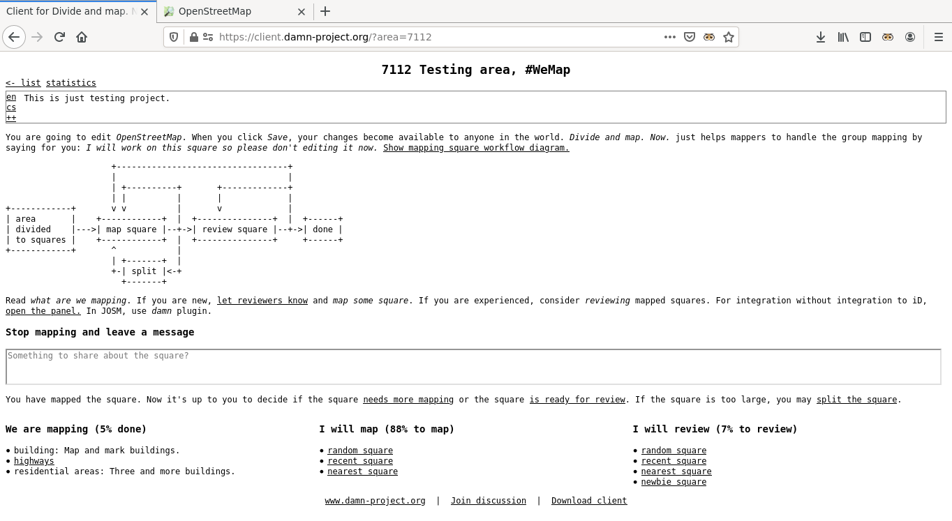
The (lightweight) client keeps with the common mapping workflow: Map -> Review -> Done. It’s meant to load fast with the minimum data transfer. It tries to avoid rushed clicks of newbie mappers by putting the phrases of “needs more mapping”, “is ready for review” or “split the square” into the sentence. Newbie mappers may click “let reviewers know” as I’ve already wrote.
Posted by dcapillae on 12 March 2021 in Spanish (Español).
Last updated on 7 June 2026.

He ajustado los contornos del parque forestal Ciudad de Málaga con la misma técnica que empleé para el parque periurbano La Concepción, basándome en un mapa sobre el terreno y usando el complemento PicLayer de JOSM.
 Panel informativo del parque forestal Ciudad de Málaga donde se aprecian los límites del parque. Fuente: trabajo propio (CC BY-SA 4.0) disponible en Wikimedia Commons.
Los contornos del parque estaban mapeados muy pobremente hasta ahora, ni siquiera se aproximaban a sus límites reales. En las próximas semanas intentaré definir mejor los límites del parque, añadirle más equipamientos y terminar de mapear algunos objetos naturales del entorno.
Posted by Supaplex030 on 12 March 2021 in German (Deutsch).
Last updated on 25 February 2023.

This post is also available in English.
OSM-Daten bieten das Potential, präzise Parkplatzzählungen und Parkraumanalysen durchzuführen und damit wertvolles Wissen für Diskussionen rund um die Verkehrswende, Stadtentwicklung und Mobilität bereitzustellen. Vielerorts gibt es nämlich noch gar kein systematisches Wissen, wo es wie viele Parkplätze am Straßenrand (oder auch darüber hinaus) gibt. In aufwendigen Studien müssen diese Daten bei Bedarf erfasst werden – und meist sind diese Daten anschließend nicht für die Öffentlichkeit zugänglich. Im Gegensatz dazu stellt OSM eine optimale Umgebung dar, in der solche Daten frei zugänglich erfasst und analysierbar gemacht werden können.
Am Beispiel des Berliner Stadtteils Neukölln haben wir demonstriert, wie urbane Parkplätze systematisch auf OSM-Basis kartiert und mit Geoinformationssystemen (hier: QGIS) und unter Einbezug weiterer offener Daten hochaufgelöst ausgewertet werden können. Dieser Blogpost soll euch einen Überblick über die Methodik geben und ein paar wichtige Ergebnisse und Erfahrungen für die OSM-Praxis mit euch teilen.
Einen ausführlichen Blick auf die Ergebnisse und Daten könnt ihr in der Neuköllner Parkraumkarte werfen, in der die Parkplatzinformationen visualisiert werden, die zugrunde liegenden Daten zum Download bereit stehen und bei Bedarf ausführlichere Infos zur Herangehensweise und Methodik zu finden sind.
Posted by Supaplex030 on 12 March 2021 in English.
Last updated on 25 February 2023.
This post is also available in German / Dieser Post ist auch in deutscher Sprache verfügbar.
OSM parking space data can be a great source of information for the debate around urban development and the transition towards a more sustainable transport system. In many places, there is still no systematic knowledge of where and how much parking is avaliable along the road and beyond. Right now, this data is usually only collected as a part of expensive studies, which are usually not available to the public once they are done. In contrast to this, OSM is an environment in which such data can be freely collected and analysed.
Using the Berlin district of Neukölln as an example, we have demonstrated how urban parking spaces can be systematically mapped using OSM as a basis. We then analysed the collected information at high resolution using geoinformation systems (here: QGIS) and incorporating other open data. This blogpost will give you an overview of the methodology and share some important results and experiences for OSM practice.
You can take a look at the results and data in the Neukölln parking map, where different parking information is visualised, the underlying data is available for download and more detailed information on the approach and methodology can be found (in German).

I got a few messages last night from “fake 18+ bots” that I was suprised they are on OSM, since they message me a lot on Instagram. Is this a new or old problem because I have only been a member for a year now and never had a problem with them until now.

I am mapping using OpenStreetMap because I want to make the world a better place.

I just spent a little while writing a feature extractor for water tanks; having come across a well mapped dataset on Kangaroo Island, SA.
While not the easiest, fighting windows 10 to get a working dev environment - vagrant, busted; python on windows lack dependencies, etc; finally some success with the windows linux subsystem…
… robosat is actually pretty simple!
I cant be the first to think this - is there a model zoo equivalent for OSM trained models?

The Arthur Grey Low Traffic Area is a series of modal filters and other traffic interventions in Onehunga, Auckland. These filters are changing the routing network for cars, whilst maintaining access through the existing network for pedestrians and bicycles. Link to detailed intervention designs.
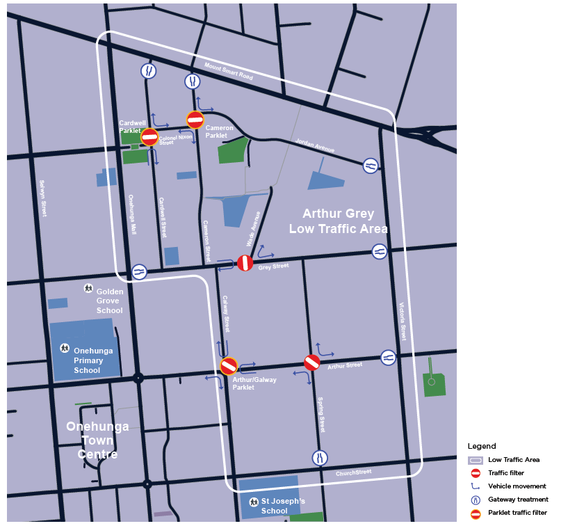
The interventions are being installed for a trial/pilot period, and are likely to take a different form in their final form (if they are made permanent at all). It is important to map these so that routing is up to date, especially for cars which are significantly affected.
Because the interventions are likely to change in future, it will be useful to keep track of the changesets I have made, in order to quickly access them for review in future. I am using the hashtag #arthurgreylowtrafficarea for relevant changesets, and will maintain the list below.
Changesets
Arthur/Galway Street intersection:
Arthur/Spring Street intersection:
Posted by raphaelmirc on 11 March 2021 in Brazilian Portuguese (Português do Brasil).

UmbraOsm - União dos Mapeadores Brasileiro do Openstreetmap.
Site com muitas Informações e Ferramentas para o Openstreetmap; Acesse;
UmbraOsm - Union of Brazilian Mapmakers from Openstreetmap.
Site with lots of Information and Tools for Openstreetmap; Access;
Raphael de Assis
Posted by raphaelmirc on 11 March 2021 in Brazilian Portuguese (Português do Brasil).
Mapeamento Colaborativo e Humanitário, Mapeando o desmatamento na floresta amazônica com JOSM / FRIDAY, MARCH 12, 2021 FROM 12:00 UTC-03 TO 15:00 UTC-03
Mapeamento Colaborativo e Humanitário, Mapeando o desmatamento na floresta amazônica com JOSM / FRIDAY, MARCH 12, 2021 FROM 12:00 UTC-03 TO 15:00 UTC-03
Collaborative and Humanitarian Mapping #2: Mapping deforestation in the Amazon rainforest with JOSM.
Raphael de Assis Mapeador da Kaart Brazil

My February 2021 in OSM
Last few months have been weird. Those of us in more northern latitudes (I’m at 49° North) are just coming out of winter, with much shorter days. The coronavirus lockdowns make most regular social life is cut off. I (& most people I care about) have been lucky enough not to catch corona, but I’m noticing everyone is more snappy than normal.
Posted by raphaelmirc on 10 March 2021 in Brazilian Portuguese (Português do Brasil).
Pra comemorar os 10mil Changesets, O Mapeador Tomio Cria um video basico no Youtube de Como Inserir Casas Usando o Editor ID. Link do Vídeo:
To commemorate the 10 thousand Changesets, The Mapper Tomio Creates a basic video on Youtube of How to Insert Houses Using the ID Editor. Video Link:
Posted by Leigh Dodds on 10 March 2021 in English.

I just added a new query to OSM queries called Mapping Bench Inscriptions.
It illustrates how even a simple OverpassQL query coupled with some conditional MapCSS styling can produce a nice map that can guide a local survey.
In this case its focused on mapping public benches and adding inscriptions and photos to OpenBenches.
There’s a more detail in the query description, but in brief it highlights benches that:
- don’t have a backrest tag (I see Street Complete also features this as an improvement)
- have a backrest but no inscription - some benches do and in some locations, particularly along the UK coastline, many do
- those that have inscriptions but aren’t linked to OpenBenches
- ..etc
Hopefully both a useful query and an nice illustration of MapCSS at the same time.
Posted by raphaelmirc on 10 March 2021 in Brazilian Portuguese (Português do Brasil).

A UmbraOSM União dos Mapeadores Brasileiro do Openstreetmap lança mais um desafio nesse sabado dia 13 de Março de 2021 com objetivo de mapear Ruas sem Nome no Estado da Bahia, juntamente com apoio das Meninas da Geo do Pará e do Capitulo do youthmappers do Pará.
Abaixo segue o link no Maproulette das Tarefas que serão feitas no dia 13 de Março de 2021:
Cidades a Serem Mapeadas no Estado da Bahia.
Inserir Nomes de Rua na Cidade de Mundo Novo-Bahia. - https://maproulette.org/browse/challenges/17373
Inserir Nomes de Rua na Cidade de Miguel Calmon-Bahia. - https://maproulette.org/browse/challenges/17374
Inclusão de Nomes de Rua na Cidade de Segredo-Bahia. - https://maproulette.org/browse/challenges/17375
Inserir Nomes de Rua na Cidade de Barra do Mendes-Bahia. - https://maproulette.org/browse/challenges/17627
Inserir Nomes de Rua na Cidade de itaetê-Bahia. - https://maproulette.org/browse/challenges/17626
Posted by c tito young on 10 March 2021 in English.
Last updated on 17 April 2021.


In a geoglyphic area of 50m x 50m two elliptically oiled snakes connected by a third snake, oriented east to west. The snake bodies, of long, medium and short lengths are etched inside a Nazca Trapezoid shape connected by nearby adjacent Nazca Lines. These three snakes are not identical and lay on flat land. The etching suggests one head is located in the center of the spiral, and a second head is located at the spiral’s 4’o’clock position on the outside of the circle and a third head located towards the 3 o’clock position of that spiral. 30m away, connect to this three snake ensemble but yet another snake is another snake in coil, also all in the east west coordinates.
14°40′49″S, 75°6′10″W -14.6803188, -75.1028690 El Ingenio, Province of Nasca, Ica, Peru
Note Must view with Maxar Premium Imagery (Beta).
A 150m x 50m twelve point start on relatively flat ground is on the border of Nazca Lines and the nearby hillside. The points radiate from a central location 10m and the rays (about 1m in thickness) and will stretch away from the center as much as 120m.
14°41′27″S, 75°8′41″W -14.6909499, -75.1447104 El Ingenio, Province of Nasca, Ica, Peru
A 50m x 50m geoglyph of a spiral coils from the outside towards the inside. The path is averages about 1m wide and starts from the edge. The Spiral is located on relatively flat ground and is bordered between Nazca Lines and a hillsides.
14°41′23″S, 75°8′17″W -14.6898290, -75.1380800 El Ingenio, Province of Nasca, Ica, Peru