Users' Diaries

Recent diary entries

Posted by valerietheblonde on 15 February 2021 in English. Last updated on 4 April 2021.

Background

My girlfriend is embarking on a through-hike of the Appalachian Trail (AT) this year and that started me wondering about how the OpenStreetMap US Community organizes itself around maintaining trail systems. Over the past few years I have been working on the Florida National Scenic Trail, more commonly known as the Florida Trail (FT), starting with the rerouting of the FT through Split Oak Forest WEA, the site of my Masters thesis work.

Status in OSM

I have worked hard to map this park in OSM and have completed the FT through the park and up through Moss Park and Crosby Island Marsh Preserve. The trail is not yet connected to the rest of the FT in Central Florida. The FT is mentioned in two places on the Wiki - under the National Scenic Trail heading of the United States/Long distance trails page and the Florida page. The United Sates/Long distance trails page lists a ten National Scenic Trails, one of which links to the OSM wiki (because I just changed it). and the rest link to their wikipedia pages. The PA - Mid-State Trail also links to its own OSM wiki page which is cool because it even has a progress bar! I asked the OSMUS Slack channel if there’s an organized group or effort maintaining the AT and the answer is no, and @datamongers pointed out that the AT is pretty complete, even being covered by a superrelation.

Proposal

I propose that I start out by creating OSM Wiki pages for each trail (Done - FT, AT) and link to them in the United States/Long distance trails page (done).

Then, check for status and completeness of both the AT and the FT including route, closures, trailheads, and shelters.

Trail segment completeness

See full entry

Location: Lake Mary Jane, Orange County, Florida, United States
Posted by c tito young on 15 February 2021 in English. Last updated on 10 March 2021.

A 150m Long x 50m Wide geoglyph of a jumping man oriented north to south situated almost upside-down on a moderately sloped hillside that changes elevation almost 40m. The abstract man, seemingly with an outstretched arm over his head and appears too want to take off in flight.
This depictions suggests using natural formation and etchings to create the face and the geoglyph figure. The jumping man has a triangle shaped head, which seems to be referring to the massive numbers of triangles all over the Nazca valley. The triangle could have some references to the elongated head as well.

Location: Ventilla, El Estudiante, El Ingenio, Province of Nasca, Ica, 11350, Peru

SotM2008でOpenSteetMapの創始者スティーブ・コーストとはじめてお会いました。若いスティーブ・コーストの基調講演を聴きながら、この人がOSMを始めたんだーとこの時は遠目に見るだけでした。 OSM 、SotMつながりでこの後も長いお付き合い、私の考えの支えとなる(日本にいても顔が浮かぶような)皆様、明るく楽しい皆様、とここSotM2008で初めてお会いしました。 SotM開催中、アイルランドからメーリングリストtalk-jaで日本のコミュニティにSotMの情報を伝えたり、関心事の質問受けたりもしていました。

カンファレンスに飛び込んだ私は、OSM活動を始めて間もない時期ですから、本場では、「どこの国がOSM先進国?」「どんな方法でOSM地図を描いている?」「マッピングパーティーはどんな感じ?」「OSM地図、データの利用は?」「新しい技術を知りたい!」と様々なOSMの情報が知りたい気持ちでワクワク前のめりで見聞きしていました。 そんな中、目に留まったのが「Threat Analysis: Things That Could Spoil Our Party」の講演でした。それまで、私自身オープンなコミュニティ活動経験はゼロでしたし、OSM描くぞとそればかり考えていたのでコミュニティをどう考えるといった思考は全くありませんでした。 そんな頭で”Happy OSM country where the sun always shines.”のスライドを見せられました。インパクトありました。GPS持ってログ取り、OSM描いて楽しいとだけ思っていられるのは今だけなのかな?と考えてしまったフレデリックさんとの初対面でした。

sotm2008_happyosm


Active mapping daysが3月に3000日となります。 記念としてカウントダウン的にOSMに関わる出来事についてふりかえり日記を書いています。 マッピング日数は“How did you contribute to OpenStreetMap?”を参考にしています。Pascal Neis氏に感謝します。

See my previous entry for installation instructions.

So far, mapillary_tools has worked very well for me! Images are sent to Mapillary MOSTLY facing the correct direction, with duplicates (from stopping at intersections, and such) being removed. The work I must do afterwards has been cut dramatically. This makes wandering to new places to capture images a fun adventure for me, and makes editing OSM with captured images + GPX a lot smoother of a process.

I capture images at 1 per second in a vehicle (any faster, and my GPS gets wonky), or 3 or 5 per second while hiking. I use pretty harsh duplicate detection, since my phone’s compass is terrible, and my GPS wanders anywhere in a 1m range while I’m stopped, given enough time. My favorite command to run is:

mapillary_tools process –import_path storage/dcim/Trip1 –cutoff_time 30 –duplicate_distance 1.5 –duplicate_angle 360 –interpolate_directions –offset_angle 0 –overwrite_EXIF_direction_tag –user_name jesseakaraccoon –advanced

Results look good!

The part “–interpolate directions” is like using “normalize sequence” while editing. It’s not perfect, but it’s great! I’ve reported a minor flaw, which causes some images at stops to point in odd directions.

Location: Broadway, Eureka, Humboldt County, California, 95564, United States

Personally ,I think it is best to use Bing Imagery for adding new things to the map as it is often has the most up to date imagery ,but if you are adding things that were always there IRL but not on OpenStreetMap(In the UK), then you should use OS OpenData Streetview.

Location: Thomas County, Kansas, United States

Correções / Melhorias.

tenho feito nos ultimos dias correção de nomes de Ruas e Avenidas no Estado de Pernambuco, tenho notado que vários estados precisa ter seus nomes de ruas corrigido e por isso criei essa tarefa  no Maproulette para o estado de pernambuco; https://maproulette.org/browse/challenges/16916 

Através de consulta no overpass; https://overpass-turbo.eu/s/13Cr você pode pesquisar qualquer cidade, basta mudar o nome do estado.

a Tarefa esta disponível no site do Maproulette para correção do nome de Rua.

I’ve been doing street and street name correction in the State of Pernambuco for the past few days, I’ve noticed that several states need to have their street names corrected and that’s why I created this task on Maproulette for the state of Pernambuco; https://maproulette.org/browse/challenges/16916

Through consultation in the overpass; https://overpass-turbo.eu/s/13Cr you can search any city, just change the name of the state.

the Task is available on the Maproulette website to correct the street name.

Raphaelmirc

Membro da UMBRAOSM - http://www.umbraosm.com.br

Membro da FOSM.

Recife/PE.

Posted by c tito young on 14 February 2021 in English. Last updated on 15 April 2021.

A geoglyph of what appears to be a 75m x 75m seabird on a slightly sloped 10m elevation difference in the hill. With its beak facing northeast and tail facing southwest, this sideview manmade geoglyph displays a bird and wings in flight head, long beak and one eye. Also visible are the suggestions of feathers and differences between head, body and wings. The seabird bird is less than 3m from the bird of which it attacks.

14°52′35″S, 74°55′35″W -14.8763590, -74.9263191 Vista Alegre, Province of Nasca, Ica, Peru

Location: La Primavera, Vista Alegre, Province of Nasca, Ica, 11401, Peru

You can install mapillary_tools on an Android device without rooting it. Here was my process:

Start by downloading Termux, a good command line program for Android.

Then, install mapillary_tools according to Linux instructions on the README. However, because Python 2 is no longer supported, the “pip” command seen in the readme will not work.

Use the command…

pkg install python2

…to install the necessary version of Python. Then follow instructions as-is, but replace instances of “pip install” with “python2 -m pip install”

Finally, on Termux, you must run the command “termux-setup-storage” to access the device’s internal storage.

As a non-programmer, this took me a while to figure out. I hope this helps someone!

Posted by ikiya on 13 February 2021 in Japanese (日本語). Last updated on 15 February 2021.

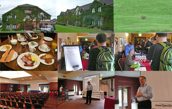
2008年7月アイルランドのリムリック、静かな郊外にあるキルマリー ロッジ ホテルでState Of The Map 2008が開催されました。State Of The Mapと銘打ったOpenStreetMap国際会議はこれが2回目になります。第1回会議は2007年イギリス、マンチェスターで開催されました。SotM2008参加者はおそらく80名程度だったと思います。OSM活動が始まったばかりの日本からはmiurahrさんと私が参加しました。成田からヒースロー空港、バス移動でスタンステッド空港へそこからアイルランドのシャノン空港、そしてタクシー乗合で飛ばして、いろいろあって深夜2時会場着。海外初心者、勝手がわからない私には遠い道のりでした。翌朝、「Good morning!」と受付会場入り、初対面の皆さんと過ごす2日間SotMの幕が開きました。 sotm2008_712 2008年当時、私が書いたコメントです。

「深夜、ホテルにチェックインして迎えた翌朝、外は薄曇り、庭には野うさぎが跳ねていました。ホテル内のU2やABBAの曲が流れるレストランで朝食。Registration開始は8:30、参加申し込み、参加費送金は問題なかったかドキドキしながら列に並びます・・・ありました私の名前。ネームプレートと記念Tシャツを受け取って会場入りしました。最前列に陣取り、電源確保、講演の開始を待ちます。 9:30 Robert Barrさんの基調講演「The Megagalactic super visible street sign company」が始まりました。期待の2日間の始まりです。」


Active mapping daysが3月に3000日となります。 記念としてカウントダウン的にOSMに関わる出来事についてふりかえり日記を書いています。 マッピング日数は“How did you contribute to OpenStreetMap?”を参考にしています。Pascal Neis氏に感謝します。

En agosto de este año 2021, YouthMappers, Universidad de Panamá (Jóvenes Mapeadores de la Universidad de Panamá) celebrará su quinto año. Al celebrar este hito, es casi imposible no pensar en los desafíos que hemos superado y los numerosos logros que hemos tenido. En el 2016 la Dra. Patricia Solís cofundadora de los YouthMappers me contactó para contarme sobre este importante proyecto donde, utilizando Open Street Map (OSM), los estudiantes podrían conectarse con sus compañeros de todo el mundo, mapeando comunidades y áreas con el propósito colocarlas en el mapa y de alguna forma a través de esta información, darle voz a los que no la tienen.

Un par de años antes, había trabajado con la Dra. Patricia Solís y la Dra. Marie Price colaborando en un programa de estudios en el extranjero aquí en Panamá, donde pudimos reunir a estudiantes de la Universidad George Washington y la Universidad de Panamá para trabajar en un proyecto en el distrito histórico. Resultó que nuestros estudiantes de ambas universidades estaban entusiasmados con esta experiencia que crearon lazos de amistad que perduraron aún después de culminado este proyecto.

Esta experiencia me mostró la necesidad de enfocarnos más en tratar de encontrar estos espacios donde nuestros estudiantes pudieran ampliar sus conocimientos académicos, escuchar otras experiencias y participar con otros estudiantes en la solución de problemas de la vida real, que pudieran mejorar la calidad de vida de otras personas. De allí que YouthMappers se presentaba como una gran oportunidad para nuestros estudiantes, y tener un capítulo en la Universidad de Panamá los alentaría a participar en esta iniciativa de voluntariado.

See full entry

In August of this year, 2021, the YouthMappers, Universidad de Panamá (Jóvenes Mapeadores de la Universidad de Panamá) will celebrate its fifth year. As we celebrate this milestone, it is almost impossible not to think about the challenges we have overcome and the numerous successful accomplishments. In 2016 Dr. Patricia Solis cofounder of the YouthMappers contacted me to tell me about this important project where, using Open Street Map (OSM), students could connect their peers from around the world, mapping communities and areas with the purpose of revealing the hidden, to give the voiceless a voice.

I had worked with Dr. Patricia Solis and Dr. Marie Price a couple of years earlier, collaborating on a study abroad program here in Panama where we were able to bring together students from George Washington University and the University of Panama to work on a project in the Historic District. It turned out that our students from both universities were excited about this experience and created ties of friendship that continued after this project.

To me, this experience showed me that we needed to focus more on trying to find these spaces where our students could expand their academic knowledge and be able to listen to other experiences and participate with other students in solving real life problems that could change in some degree other people´s lives. So, I thought that begining a YouthMappers chapter would be a great opportunity, to encourage students to participate in this voluntary initiative.

To begin this process, I talked to my colleague Professor Humberto Smith and others to help me in this task. Although for some colleagues it was difficult to get involved due to their busy schedule, they tried to help us spreading the word among students. Professor Smith and I decided to continue this endeavor, and we were able to motivate a group of students who helped us to create the YouthMappers, Universidad de Panamá chapter.

See full entry

Posted by c tito young on 13 February 2021 in English. Last updated on 10 March 2021.

A geoglyph of a giant head 50m wide x 100m long, oriented north to south, is part natural feature and man-made modifications hidden in a steep hillside with a change in elevation of 40m. Its drawn view give an impression of a huge grinning smiling person with long hair. It has shifty half closed circular shaped eyes, with its face accented in a split tone of dark and light. The giant head’s shape appears abstract, elongated and thin.

Southeast of this artwork is the famous “Hummingbird” geoglyph just 200m away.

Location: entrada al ingenio, San Miguel de la Pascana, El Ingenio, Province of Nasca, Ica, 11350, Peru
Posted by c tito young on 13 February 2021 in English. Last updated on 15 April 2021.

A geoglyph of a face wearing a crown, 18m long x 10m wide, oriented east (chin) to west (crown) is seems to be located under the geoglyph called Lounging Cat. Fairly noticeable is an impression of a large face with two eyes, nose and mouth, wearing a crown. The face’s eyes look straight forward with its mouth that seems to be open as if calling or making a sound. The crown, is suggested to be worn on the head, with large circular shaped ornaments. The head lays on slight hill.

Less than 3m away from the “Face Wearing Crown” is the “Lounging Cat”.

14°42′27″S, 75°6′8″W -14.7076254, -75.1023148 El Ingenio, Province of Nasca, Ica, Peru

Location: El Ingenio, Province of Nasca, Ica, 11350, Peru