Users' Diaries

Recent diary entries

It seems that I forgot to add a Diary Entry yesterday.

Yesterday I mapped the village Renz and the surrounding areas.

Today I started with Demiraj which was fully mapped (Thanks to DenisJu which has done an amazing job mapping Shkodra and the surroundings) so I moved next on the list.

I mapped the village Slatinjë which was really tiny, so I decided to map also Radesh and Gradec.

“#100villagesin100days #day33 #day34”

I am finding shapes and believing that I have discovered a very important pattern not completely mentioned earlier. Using those principals in those pattern shapes many geoglyphs are appearing over and over. Some are of animals and others of what appears to be humans. Most see to use the natural hillsides and valleys and then some modifications to the terrain to bring out the features with the figures. These are not easy to spot, as I have been trying to spot some for quite a while, only recently appearing of which I can’t unsee.

At some point I’ll make some kind of formal presentation but for now I am continuing to lay shapes down.

Incidentally, I am not using any AI or Google Earth enhancers of any kind. Most shapes are not indicated, and some may be part of a previously discovered shape. If I see shapes over shapes, I’ll try to add a second line type.

For years, I’ve been an active contributor to OpenStreetMap (OSM) – starting as a mapper in college (2017) and evolving into a trainer, leading over 30 trainings and reaching more than 1500 people. Recently, I took my commitment to the next level as a Trainer Fellow with Open Mapping Hub Asia Pacific (OMH AP). This 5-month journey wasn’t just about delivering training; it was about wearing a new hat – that of an organizer.

The Guru fellowship involved five trainings, including three online, one in-person (which I’ll delve into), and one where I acted as a support trainer. While every training experience is unique, this in-person workshop held a special place.

The in-person training titled “Map and Chat: Open Mapping Hands-on Workshop for DRR 2024”, held on April 28-29 2024, was designed for bachelor students with diverse backgrounds in Kathmandu, Nepal, in collaboration with Open Mapping Hub Asia-Pacific, Sendai Stakeholders Children and Youth Group, UN Major Group for Children and Youth (UNMGCY) and ALIN Foundation Nepal. The workshop aimed to equip them with hands-on open mapping tools and knowledge for disaster risk reduction (DRR).

Stepping Up: The Organizer’s Hat

While I was accustomed to crafting training materials and schedules, organizing demanded a whole new set of skills. The in-person aspect brought a new layer of complexity of logistics. Suddenly, I was creating Google Forms, counting water bottles and pens, designing posters and certificates, budgeting and managing finances and also analyzing participants’ backgrounds to tailor content effectively (as I usually do as a trainer. Gone were the days of solely focusing on the curriculum.)

See full entry

Location: Kathmandu-11, Kathmandu Metropolitan City, Kathmandu, Bagamati Province, 44617, Nepal
Posted by valhikes on 8 July 2024 in English. Last updated on 9 July 2024.

About a year ago, I actually encountered a use of highway=road as I aligned roads and added a bit more detail to the area at the south end of Mendocino National Forest. And what is a “road”? A placeholder! “Undefined” is actually quite defined comparatively. I investigated what it should be a placeholder for and found it was marking an ATV trail. It had been there a few years and could survive a few more.

Since JOSM doesn’t even seem to know one might want to set a value called “atv”, perhaps I should explain. Also called a “quad”, these narrow little four wheeled things can’t quite go everywhere a motorcycle can go, but they’ll get a lot more places than a 4x4 vehicle. There were 3 wheeled ones (probably still are in other places) but they were banned because they killed people more often due to rolling more easily. People grumbled at first. Three wheels is more fun! But they seem happy now. It hurts to roll over. Often tagging goes a little like this:

highway=[um]
atv=yes/designated
motorcar=no
maxwidth=1.27

(No side-by-sides, as the signs in Colorado often said! Those are often known as ATV or UTV.)

But is [um] a path or a track?

Well, the wiki on “path” is quite clear: “A highway=path is not for use by four-wheeled (two-track) vehicles.” Then it muddles a little: “A path-like way where four-wheeled vehicles are allowed, is likely better tagged as a highway=track or highway=service.” Only “likely”.

Meanwhile, on the wiki on “track” we find that track is “generally not appropriate” for “A trail or path that is not wide enough for a typical four-wheeled motor vehicle.” There is a footnote to clarify this: “A “typical four-wheeled motor vehicle” means a general purpose or average motor vehicle commonly used in a given region. The size and capability of what is considered a typical, common, or average vehicle varies around the world.”

See full entry

Location: Rice Fork Summer Homes, Lake County, California, United States

Today I started with Llëngë, a village with a population of around 75. After that I moved around in the villages in Pogradec and mapped a little here and there.

I decided to go back to my hometown and I continued mapping the city of Çorovodë, which still needs some work. I will map with EveryDoor when im there next time. Furthermore, I moved further to the village Sharovë, Prishtë, Rehovicë (which is my grandfather’s village) and finally I partially mapped Çepan.

I am sure I have forgotten some villages because today I roamed a lot on the map and I can say this Sunday started very good.

Time to translate a Wikipedia article to Albanian now. Another challenge among some Wikimedia friends.

“#100villagesin100days #day32”

Treinamento teve foco na representação de feições com dados do Censo Demográfico 2022 (Brasil) e da cartografia social realizada no estado

IVIDES.org promoveu uma oficina híbrida sobre mapeamento colaborativo com OpenStreetMap e criação de mapa Web com uMap, para turma de estudantes de geografia da Universidade Federal do Ceará (UFC) e o público em geral.

Na oficina, foram mapeados dados de estabelecimentos educacionais*, de três cidades cearenses - Paracuru, Caucaia e São Gonçalo do Amarante e de cartografia social**, com demonstração da criação de mapa Web com uMap, contendo camadas estáticas e dinâmicas, e com personalização de ícones.

No programa do treinamento, foram abordados: conceitos importantes de mapeamento colaborativo; modelo de dados, editores e aplicativos para dispositivos móveis, download e upload de dados do OSM; e três plugins para QGIS, importantes na criação de mapas estáticos. Além disso, foi mostrado rapidamente como utilizar o editor iD e consultar as etiquetas na Wiki OSM Map Features e no próprio editor.


Os arquivos da oficina e um roteiro para prática estão disponíveis em português, na pasta virtual. O vídeo gravado da sessão pode ser encontrado no canal IVIDES no YouTube

See full entry

Location: Centro, Fortaleza, Ceará, Região Nordeste, Brasil
Posted by GanderPL on 6 July 2024 in English. Last updated on 11 July 2024.

I started working on a helper for OSM because I use several community-made tools, and it’s not very convenient to copy and paste links, nodes, or IDs into these tools. So, I decided to write my own userscript. This script will detect what the user is currently viewing and attach the appropriate links already prepared for the tool.

It’s a very simple script, and anyone can create something like this. However, I plan to use AI to help with tagging in the future. It began with a simple rule I used for tagging points, which made me realize I could automate it more. This will be implemented in the helper.

The helper will use Vue.js to control the interface view. In future I plan to release an extension for Chrome and Firefox.


I would appreciate any suggestions or links to web applications that might be useful.


Current releases

nettoyage de la ligne 702000 (Ligne de Montluçon à Saint-Sulpice-Laurière) : 52 PN normalisés, quelques TVP (traversées des voies pour le public) , points de construction X3. ( 1400->4200 pts pour 112 kms) 5 jours de boulot dépaysants. prochaine cible : ligne 712000 (Ligne de Busseau-sur-Creuse à Ussel) : 51 PN au programme

Embarking on the Osm Guru Fellowship was an exciting and transformative experience. This five-month-long journey focused on mapping track has provided me with a unique opportunity to enhance my skills and knowledge in OpenStreetMap (OSM). Each month presented a new task and challenge, pushing me to explore different tools and techniques within the OSM ecosystem.

The first month introduced us to the basics of OSM. Our task was to map a specific area using the OSM platform. This involved adding and editing features on the map, such as roads and building features. In the second month, we focused on collecting Points of Interest (POIs) using the Every Door app. This tool was new to me, but through hands-on exercises, I became familiar with its features. Our task was to identify and document various POIs in a designated area, such as restaurants, shops, and public facilities. This exercise enhanced my ability to gather and input detailed location data. The third month centered on using Mapillary to collect street-level imagery and POIs. We were tasked with capturing images of streets and integrating them into the OSM database. Additionally, we used the imagery to identify and add POIs. By the fourth month, our task was to create a map using the POIs we have collected before. The final month was dedicated to the validation. We were assigned to validate feature such as buildings and roads.

The Osm Guru Fellowship was a transformative experience. Each month’s task helped me develop a deeper understanding of mapping and OSM tools such as Every Door and Mapillary. I am now confident in my ability to contribute to the OSM community and use these tools effectively. This fellowship has greatly enhanced my skills and appreciation for the importance of accurate and detailed mapping.

Posted by a2021 on 6 July 2024 in Japanese (日本語). Last updated on 3 October 2024.

長らく使っていないため、slackにログインできなかった。(その後、ログインできた。) 記録用としては、日記の方がいいかも知れないので、少し、使ってみよう。 自分が初めてOSMに触れたのは、2015年2,3月である。 ほんの少し、非常勤講師などをやっていたが、余裕がたっぷりできた頃である。 ハイキングには地図がいる。オフライン地図を探し、OSMに出会った。 Google Mapなどに比べると、はるかに内容が乏しいが、オフラインで使えること、 自由にカスタマイズできることが魅力でOSMを使うことにした。 1、2か月で自作OSM地図が完成して、散歩やハイキングの友となった。 1年間10インチWindowsタブレットに自作OSM地図を載せた。 10インチは大きすぎ、1年で8インチWindowsタブレットに変えた。 3年ほど前から Androidスマホに変えた。 デバッグや自宅利用は 8インチAndroidタブレットを使っている。

この9年間でOSMの情報量は増え、精度も向上している。 旅行、ハイキング、散歩では OSMでさほど不自由は感じない。 観光地に限れば、Google Mapよりも詳細なことがよくある。

ただ、全国均質ではなく、地方にはマッパーがいないため、内容に極端なかたよりがある。

HTMLタグは使えるか?

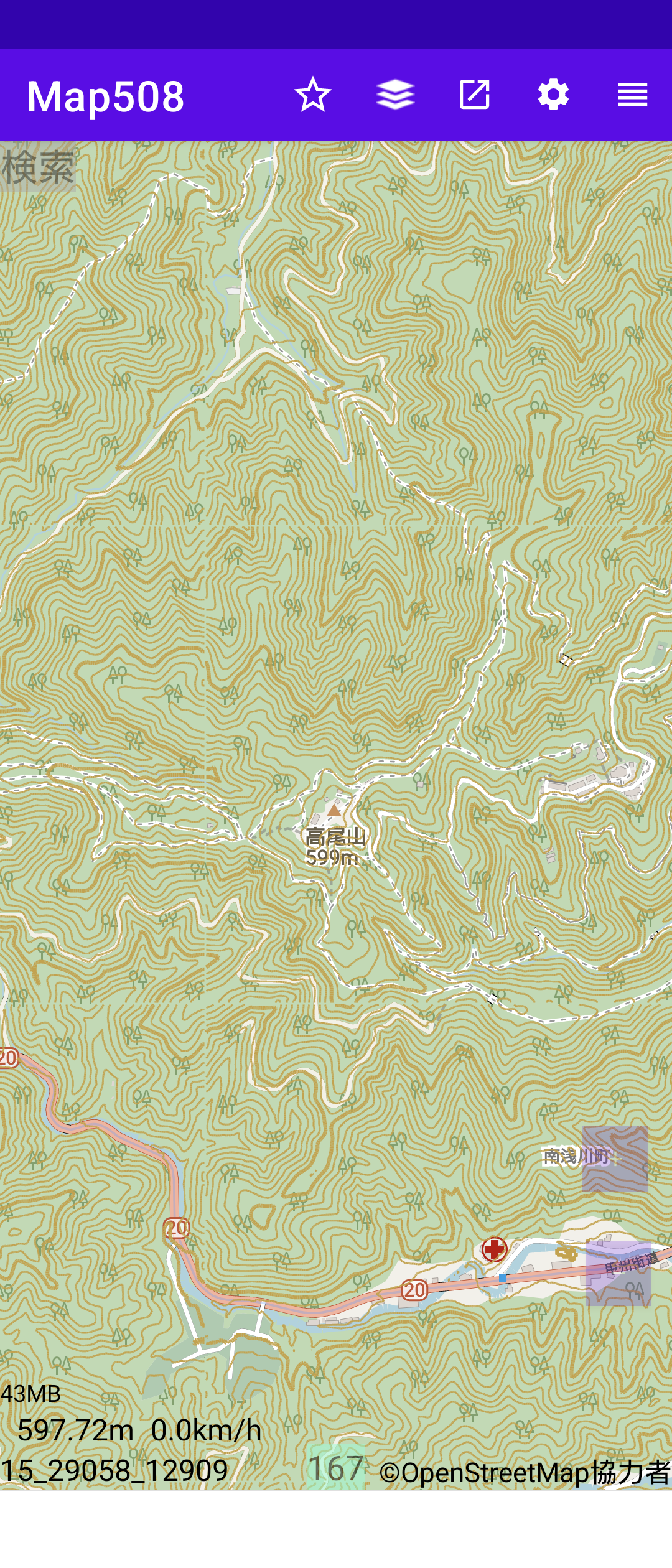
HTMLタグも使えるようだ。カスタマイズしたOSM地図に国土地理院の標高タイルから 得た標高データを使って等高線を重ねてみた。

参考資料
CONREC A Contouring Subroutine

Posted by Kingsley AMANKWE on 5 July 2024 in English.

Congrats to UMT as she clocks 7

Unique Mappers Network (UMT) has significantly impacted my personal and professional growth. Through my involvement with UMT, I have gained extensive knowledge and practical skills in geospatial technologies, which have been instrumental in advancing my career. The collaborative projects and community engagement activities have allowed me to work alongside experts and passionate individuals, fostering a strong sense of teamwork and shared purpose. Additionally, UMT’s commitment to open data and mapping for social good has inspired me to contribute to impactful projects that address real-world challenges. This experience has not only enhanced my technical expertise but also deepened my commitment to using geospatial intelligence for sustainable development and community empowerment.

On behalf of all those that has benefited from my knowledge and experience, thanks Unique Mappers Network

Location: Kukwaba, Abuja, Municipal Area Council, Federal Capital Territory, 900104, Nigeria

Today I finished mapping Shënepremte and I continued on the next village on the list. Xhan was a tiny village with just some houses scattered around the forest, so I mapped what I could and continued down the list to Floq.

Floq is a village in Korce with a population of around 1072. I was really inspired today so i went on and mapped also Pepellash and Helmës.

“#100villagesin100days #day30”

I am reading through the comment log which resulted in a 10 year ban for using junction nodes incorrectly, when can they be used

osm.org/changeset/149827539#map=12/-34.8875/138.5788

osm.org/changeset/150094405#map=12/-34.8875/138.5788

these particular junction nodes are the only junction nodes ever to be deleted and removed, how are these any different to any other junction nodes on the map and why didnt the user who deleted these ones delete any other ones?

I am just seeking help with junction nodes, not sure how to use them correctly as the reason for their removal is not a direct quote from any part of the junction nodes wiki. hoping a discussion here would help shed some light on their removal.

My name is Victor, a 300-level student of the Geography and Environmental Management Department, University of Port Harcourt.

I am very excited to announce that I have joined the Unique Mappers IT Internship program.

This opportunity aligns perfectly with my love for technology and my desire to gain hands-on experience in the field of geographic information systems (GIS) and mapping technologies.

The Unique Mappers Network Nigeria is a renowned organization due to its approach and commitment to community-driven projects, making it an ideal platform for me to enhance my skills and contribute meaningfully.

I am also excited to work with a team of talented professionals and colleagues, learning from them and sharing my ideas.

Joining the Unique Mappers IT Internship is a significant step in my career journey, and I am ready to embrace the challenges and opportunities along the way.