 OpenStreetMap

Hari ini setelah sekian lama tidak membuka OSM, mencoba seting kembali lokasi rumah, tapi nampaknya belum berhasil, karena lokasi belum nampak.
Users' Diaries
Recent diary entries
Posted by Raquel Dezidério Souto on 9 February 2024 in Brazilian Portuguese (Português do Brasil).
Last updated on 17 April 2024.

Motivação e escopo
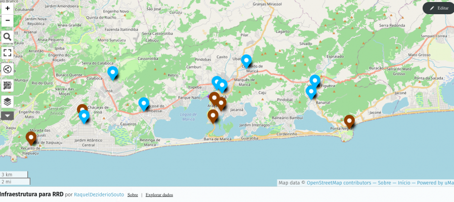
Proposta de um fluxo de trabalho para incluir pontos de interesse (POI) no OpenStreetMap (OSM), a partir de um arquivo de valores separados por vírgulas (.csv) e gerar um mapa web dinâmico.
É importante ressaltar que este procedimento pode ser realizado por mapeadores iniciantes e que é mais adequado ao mapeamento de (relativamente) poucos dados, por exemplo, escolas, postos de saúde, sirenes de emergência etc, circunscritos a uma área que poderia ser, por exemplo, carregadas no iD ou no JOSM.
Para importar maior volume de dados no OSM, é necessário ser um mapeador experiente (nível intermediário ou avançado), documentar o procedimento na Wiki OSM e obter o aval da comunidade. Esse caso não é foco deste tutorial.
Materiais
Para esta atividade, serão necessários:

Ever since visiting Mount Lassic and then making edits in the region, I’ve had this nagging difficulty: What to do with a mountain whose high point is named differently? Mount Lassic has three peaks, the highest is called Signal Peak. I eventually mapped its survey point, which is also called Mount Lassic, and hoped that was done. (Apparently I shouldn’t map survey points except at the exact point indicated, so I’ve done this WRONG. I’ll just name a peak “Such-and-such Benchmark” then. Except a benchmark is specifically a vertical control and most at peaks are horizontal controls. “Such-and-such Triangulation Station” gets a bit long. Oh, the humanity!) Unfortunately, if one searches for the mountain, one only gets the Mount Lassic Wilderness and the Mount Lassic Trail, but there’s no hint that this goes to the high point of Mount Lassic. It goes, in fact, to “Signal Peak”.
Other places where there’s a named high point (peak) different from the main mountain are Marble Mountain (with Black Marble Mountain the high point). Someone seems to have simply marked a lower peak as Marble Mountain. If one does this, there’s a bit of a debate if it is the highest white peak or the most prominent white peak. Mount Konocti with high point Wright Peak. Currently both are marked close to the high point, but the main mountain has been given a lower elevation so doesn’t show often, but it is searchable.

Yesterday, I reached the point of one million map changes and twenty-thousand changesets. Leading up to this milestone, I tracked my progress on How did you contribute to OpenStreetMap? and carefully planned to make a single edit that would be my one millionth in my twenty-thousandth changeset. I eventually made a gimmicky changeset referencing my first mapping experience. Mission accomplished! However, despite the impressive numbers, my initial sense of accomplishment faded, replaced by nagging existential questions. Have the countless hours I devoted to OSM truly been worthwhile? Why have I been doing this? What is it exactly that I have been doing? … What is OpenStreetMap, really? And there it is, a question that seems very simple, but is not. It is the same question that hides far below the surface in Xvtn’s OSM Iceberg Meme. Inspired by this meme, user rtnf put it this way: “Is it a map? A dataset? A community? A trademark that encompasses an entire ecosystem consisting of the dataset, the tagging scheme, the rendering infrastructure, and the subculture around its mappers, developer-mappers, and third-party data consumers?? What is OSM, really?”
When you invite someone to go to openstreetmap.org for the first time, the first thing they read is “OpenStreetMap is a map of the world”. The next thing you usually want to explain to them is that OpenStreetMap is NOT (just) a map of the world. We then continue showing off different rendering styles, different editors, different tagging schemes … We pride ourselves being part of a secret society, where only the sworn in know what it is actually about. We giggle when we see the Iceberg Meme because it is “so true”. We say things like: “If you have been doing this for years, you will understand”. All of this without being able to answer a very simple, fundamental question: What is OpenStreetMap?
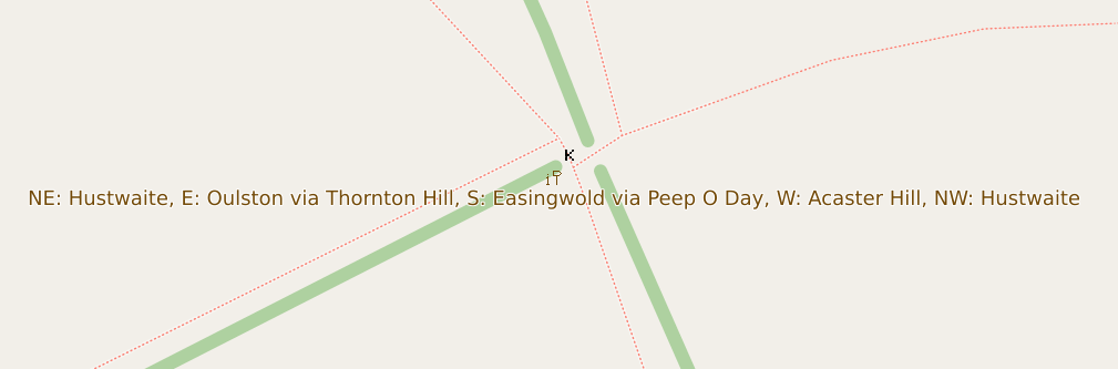
Although the raster maps at maps.atownsend.org.uk support zoom levels up to 24, until recently I’ve not made much use of that for showing extra data. However, there is a lot of room at these high zoom levels - as the picture above shows, enough for all the directions on this signpost here.
The name is shown as normal at lower zoom levels, then as you zoom in the directions are shown too, as you can see here.

1st Time Learning about QGIS and Open Street Map through Digital Mapping Workshop on Palang Merah Indonesia (Indonesian Red Cross), North Jakarta Branch
Posted by Jiri Podhorecky on 6 February 2024 in Czech (Česky).
Last updated on 5 October 2024.

Současně s tím, jak jsem se začal věnovat mapování města, tak jsem si na vycházkách všímal dalších detailů, které jsem chtěl zanést do mapy.
Všímal jsem si, jak se realizují, či spíše nerealizují některé činnosti týkající se životního prostředí, které má v kompetenci městský úřad a Odbor životního prostředí. S některými činnostmi správy městské zeleně pro mne bylo těžké polemizovat, když jsem neměl žádné přesnější podklady o výskytu, nebo množství konkrétních jevů. Bez důkazů se argumentovat nedá.
Byly to detaily týkající se především městské zeleně kdekoliv ve veřejném prostoru. A tak jsem si je musel nejdřív shromáždit:
- eko opatření ve městě
- černé skládky
- rizika území, eroze
- Květinové louky a méně sečené trávníky
- Ptačí krmítka a budky
- skleněné plochy s rizikem nárazu ptáků
- Živá divoká zvířata ve městě
- Mrtvá divoká zvířata usmrcená a nalezená v katastru města
- Zajímavé stromy
- Invazívní rostliny (křídlatka česká, lupinus vlčí bob, slunečnice topinambur)
- Suché stromy
- vodní plochy s příležitostí revitalizace a lepšího hospodaření s vodou
Bylo jasné, že tyto informace nelze vkládat do obecné OSM mapy a tak jsem hledal konkrétní aplikaci, která nabídne kombinaci jednoduchosti a možnosti zadání vlastních mapových záznamů.
Nechtěl jsem používat Google mapu, protože s tou jsem udělal už před časem nepříjemnou zkušenost. Některé funkce a služby firma Google průběžně mění tak, jak jim byznysově vyhovuje. To znamená že pro uživatele mohou nečekaně vzniknout nová omezení nebo náklady za nově placené služby. Detaily podkladové mapy se zcela nehodí na mapování životního prostředí, protože Google se soustřeďuje na komerční záznamy firem a lidmi zadávané body zájmu.

Whilst attending FOSDEM in Brussels this week-end. Of course as I’m European I was able to use streetcomplete while roaming. So I did and collected a bunch of bagdes. While spending time with a friend, as we were walking to get/find food, I was playing. When I explained what I was doing, he got immediately interested in joining, so I demoed a bit more and had one more person going to map around his home.
I’m Harrison, a hobbyist mapper based in Brooklyn, New York. I’ve been a map lover for as long as I can remember. Over the last few years I have gotten more involved in OpenStreetMap including my first trip to State of the Map US last year.
Mapping Projects
My ongoing “forever” project is mapping sidewalks in Brooklyn. With about 1,600 miles of roads there’s a long way to go! Beyond just mapping sidewalks I am working on adding curbs with accessibility details.
My most interesting mapping project has been working on the map at Train Mountain Railroad, the world’s largest miniature railroad. This started out as armchair mapping from home, then when I visited this last summer I worked on Mapillary “rail-level” imagery and other detailed mapping. The most exciting part has been the engagement from the community at the railroad getting engaged. The improved map has been immediately useful in the Train Game, and is being incorporated into a new track guide. This project has been fantastic as a complete study from all kinds of mapping to end data users.

Vous vous souvenez la semaine dernière quand je disais “mais les nouvelles images ouvrent pas mal de portes”? Et bien j’en ai profité pour… ne pas faire grand chose avec pour le moment 😅
Plus sérieusement, je n’ai effectivement pas été des plus actifs cette semaine avec seulement une poignée d’updates dans la boîte, principalement des “retouches” en rapport avec d’autres changesets récents. J’ai également fini d’ajouter les branches du Proxibus de Seraing et avait enregistré la session pour en faire une vidéo, mais c’était un peu bof pour être honnête et j’ai laissé tomber l’idée.
Au niveau vidéo, c’est aussi plus léger cette semaine avec :
Ce randonneur part faire du repérage pour chemins.be dans le Bois de l’Abbaye à Seraing - Enfin une sortie live où je pars dans le Bois de l’Abbaye pour prendre des photos pour le site chemins.be. Je montre aussi 2-3 choses que j’ai ajouté sur OSM dans le passé pour compléter ce bois
Ce mappeur OpenStreetMap retourne du côté de Bierset pour plus de modifications - Version live de ce changeset où je reviens sur Bierset après la mise à jour du SPW pour… également mettre à jour la carte OSM
Et voilà pour cette semaine. Je serai de nouveau un peu plus occupé cette semaine donc je ne sais pas trop si ce rythme continuera ou si j’aurais le temps pour trois vidéos, mais on verra bien.
A+

EN:
A lot of new mappers are trying to edit existing element instead of creating new one and set properties to them. (For example some new mapper added amenity=pharmacy to whole apartment building insted of creating one node for it.)
Also I think it would be good idea to hide some existing layers for newies (at least boundaries). New mappers do not need to work with them, because they are not changing for a lot.
In iDeditor a lot of times happens that new mapper connect road with forest boundary, because he just moved node on way for a bit and iDeditor connected this 2 elements (This can be prevented by holding Alt, but new mappers do not know this). So we can at least think about layering OSM at least for new mappers.
Also when new mapper is crating new way, which is going in the same direction as some existing way (boundary or forest boundary) he many times connect this new way with existing one.
Proposed layers:
- POI
- buildings, highways, railways
- landcover
- boundaries
In JOSM I’m using filter to hide landcover and boundaries for most of time. Only when I want to work with landcover or boundary, only then I revert filter to show only this type of ways.
SK:
Čím viac sa nad tým zamýšľam, tým viac mi to príde vhodnejšie. Veľa nováčikov sa snaží niečo pridať, lenže väčšinou len upravia existujúce elementy namiesto toho, aby pridali nové. Taktiež si myslím, že by bolo vhodné nováčikom skryť aspoň hranice. V iDeditore sa nováčikom často stáva, že spoja cestu s hranicou lesa (Nevedia, že keď podržia Alt, tak sa im to automaticky nespojí). Takže môžme aspoň pouvažovať nad nejakými vrstvami v OSM.
Navrhované vrstvy:
- POI
- budovy, cesty, železnice
- lesy, lúky, polia …
- hranice
V JOSM mám väčšinou zapnuté filtre na skrytie landcover a hraníc. Iba, keď potrebujem elementy tohto typu editovať, len vtedy si filtre prevrátim.

it’s me again speaking from beyond the grave lmao!, todays diary entry consists of a bait and switch a user is trying to do first by removing a simple note from South Australias Major Traffic Network, and therefore after based on “Whats on the Ground” change the classifications of the road network to whatever the user feels. The problem with this is that “Whats on the Ground” literally has no authority over “actual nature of the road”. If this does not make sense please read the community link below.
https://community.openstreetmap.org/t/automated-edit-to-remove-note-on-highway-trunk-in-sa/108612/12

Previous diary placeholder
Posted by Pascal Corcessin on 2 February 2024 in French (Français).
ia orana,
J’ai émis une modification pour déplacer le nom de “urufare” de l’autre cotée la baie, mais aucune modification visible. Cordialement
Improving the data within OSM around Beacon, NY and surrounding towns.
Specific road, sidewalk, and bike focus. Improve data about existing buildings and building changes. Improve trail network and information.
Posted by Jiri Podhorecky on 2 February 2024 in Czech (Česky).
Last updated on 5 February 2024.
Jedním z kanálů je Schwarzenberský kanál, který sloužil ve své době k dopravě dřeva ze šumavských lesů.
Druhým zajímavým vodním dílem je Podkrušnohorský přivaděč , někdy také nazývaný Přivaděč Ohře - Bílina. Jeho role byla jiná, sloužil především jako ochrana povrchových dolů před povodněmi.
Zatímco první kanál využívá přírodních zdrojů vody, ten druhý potřebuje načerpat vodu z Ohře a přivést ji potrubím až na začátek kanálu. Pak už voda teče sama.
A který kanál je delší? No, jednoznačně ten Schwarzenberský. V tom Podkrušnohorském zase proteče víc vody.
زیباترین مدل های لوازم تحریر

Don't map for render
Don't map for geocoder
Don't map for validator
Don't map for database
Don't map for Overpass
Don't map for editors
Don't map for laws
Don't map for statistics
Don't map for yourself
Don't map! Soon the AI will map it all out.

Map often
Map early
Map in the mornings
Map at noon
Map in the evenings
Map late at night
Map from dusk to dawn
Map on weekends
Map daily
Map every day in your heart
Map your town or city!
Map what you like
Map where you go
Map whenever possible
Map who you love
Map obscure and rare tags
Map for yourself
Map for humanitarian causes
Map alone
Map together
Map to your heart's content
Map for Light, Life, Love & Liberty
Map !

TL;DR: There are quite a few places on the continent that still need mapping. If you want to know why and how I came to that conclusion, read on ;-)
Preface
Since March 2023 there’s a handy bot called @SmallTownUSA@en.osm.town on the Fediverse, that posts a daily “task” out to its followers, highlighting “small towns” in the United States of America, that, to use the same phrasing, “seem like they could use some mapping”, along with a screenshot of the (Carto) map of the area.
Sparing the full technical details, the program randomly picks an entry from an overpass export of all nodes that have any place tag and a population tag with a value of less than 1000 (hence the name “SmallTown”) in the USA (currently 11389), asks overpass whether there are 10 buildings or less in 800 meters around that node and if so, posts about it.
As the bot has been doing this for about 10 months now, there seem to be at least 300 places that match the above description. Naturally, I wondered, how Europe would fare in comparison. Chatting with the bot’s developer, Matthew Wildon (OSM, Fediverse), they told me, that they checked France for potential candidates and found none and then didn’t look into it any further.
What’s on on the Continent?
My interest was now piqued. Would a similar “SmallTownEurope” bot make any sense, or would it run out of things to post within a week? Or is Pascal Neis’ Unmapped Places of OpenStreetMap Result Map enough to find areas where mapping is needed?