Users' Diaries

Recent diary entries

We use the data from OpenStreetMap while hiking through Colombia, Panama and Peru. It is really solid and a big thanks you to all the contributors!

One thing always stands out though. Almost all of the local people have never heard of the name ‘OpenStreetMap’. However, whenever we get information about trails they ask if we use Maps.me or recommend using it. For those that don’t know, Maps.me is simply an app showing data from OpenSteetMap!

We’re not sure why Maps.me is such a popular recommendation, though the name may be easier to remember that OpenStreetMap. We think it may simply have been one of the first apps that was free and allowed you to easily download maps for offline use?

We use an app called Organic Maps ourselves and can recommend it to anyone that goes hiking in another country. It is a privacy-friendly app and we found out it even preloads data from Wikipedia (for instance on towns, soms highlights/attractions and mountain tops).

Posted by Raquel Dezidério Souto on 12 November 2023 in Brazilian Portuguese (Português do Brasil). Last updated on 20 November 2023.

IVIDES.org promoverá o GIS DAY 2023, como parte da iniciativa global #osmgeoweek, the OpenStreetMap Awareness Week. O Instituto IVIDES.org conta com a colaboração do HUB YouthMappers Rio de Janeiro, que inclui um poll de universidades brasileiras - UFRJ, UERJ e UFRRJ. A responsável pelo evento é a Dra. Raquel Dezidério Souto - raquel.deziderio@gmail.com.

banner

As atividades programadas - palestras especiais, mapatonas e validatonas, serão promovidas para melhorar a completude dos dados no Estado do Rio de Janeiro (Brasil), uma contribuição para a redução de riscos e desastres em cidades selecionadas (nesta primeira fase do projeto) - Maricá, capital Rio de Janeiro (Mosaico das Vargens, Recreio dos Bandeirantes) e Seropédica.

Informações em:

https://ivides.org/hub-youthmappers-rio-de-janeiro-brasil

Palavras-chave: OpenStreetMap, IVIDES.org, HUB YouthMappers Rio de Janeiro, Brasil, mapeamento colaborativo.

See full entry

IVIDES.org will promote the GIS DAY 2023, as part of the global initiative #osmgeoweek, the OpenStreetMap Awareness Week. The Institute IVIDES.org has the colaboration of the HUB YouthMappers Rio de Janeiro, that includes a poll of Brazilian Universities - UFRJ, UERJ and UFRRJ. The promoter and responsible of this event is Dr. Raquel Dezidério Souto - raquel.deziderio@gmail.com (IVIDES.org).

banner

The scheduled activities - special keynotes, mapathons and validatons will be promoted to improve data completeness in the State of Rio de Janeiro (Brazil), a contribution to the reduction of risks and disasters in selected cities (at this first stage of the project) - Maricá, Rio de Janeiro (Mosaico das Vargens, Recreio dos Bandeirantes) and Seropédica.

The event is open to all and the subscriptions can be done at this direction: https://encurtador.com.br/knEFJ

Wellcome to Rio! Wellcome to OpenStreetMap and the free and open software comunity!

See full entry

EVENTO - 14 e 15 de Novembro de 2023 - GISDAY AMAZÔNIA 2023 🌿🌍

Semana de Conscientização Geográfica

EVENT November 14th and 15th, 2023 - GISDAY AMAZÔNIA 2023 🌿🌍

Geographic Awareness Week

Participe deste evento incrível e explore o poder da geoinformação na Amazônia!

📆 DATA: 14/11/23 - Presencial na UEPA/NUPAD/LEGA 15/11/23 - Híbrido - Online

🕘 HORÁRIO: 09:00 às 18:00

🤝 ORGANIZAÇÃO: LEGA (Laboratório de Estudos e Pesquisas Geoambientais da Amazônia) - UEPA

🤝 PARCERIA: Meninas das Geotecnologias - IFPA

🌟 APOIO: Esri, UmbraOSM, Youthmappers

✅ INSCRIÇÕES ABERTAS em https://doity.com.br/gisday-amazonia-2023

Não perca! Este evento é uma oportunidade única para aprender, colaborar e descobrir como a tecnologia geoespacial está moldando o futuro da Amazônia. Junte-se a nós e seja parte dessa jornada rumo à conscientização geográfica! 🌎🌿 #GisDayAmazônia2023 #Geoinformação #PreservaçãoAmbiental

See full entry

Location: Cremação, Guamá, Belém, Região Geográfica Imediata de Belém, Região Geográfica Intermediária de Belém, Pará, North Region, Brazil

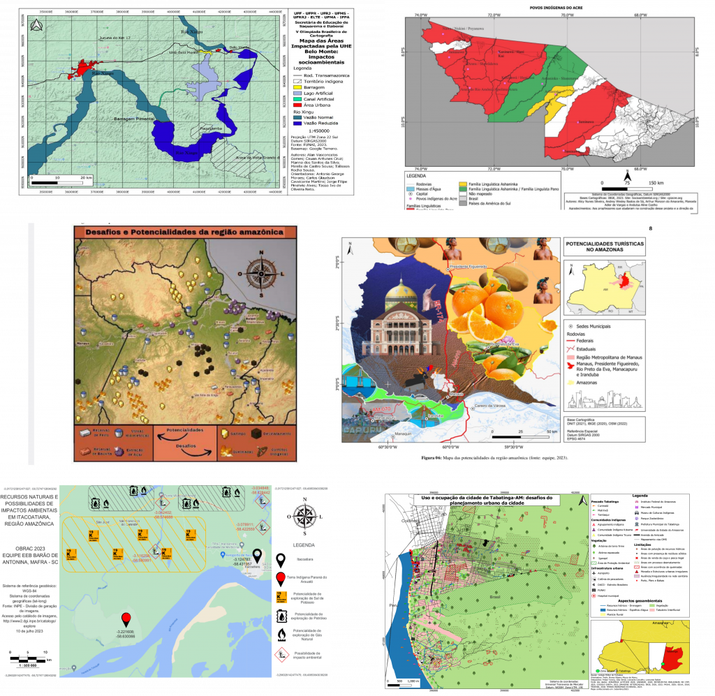
A V Olimpíada Brasileira de Cartografia - OBRAC 2023 incluiu o OpenStreetMap como parte da sua segunda etapa, de natureza prática. As equipes participantes, compostas de professores e alunos (de 14 a 18 anos), de escolas públicas e privadas e de todo o País, mapearam aspectos ambientais e socioeconômicos de áreas selecionadas da Região Amazônica brasileira, utilizando editores on-line e aplicativos para mapeamento com o OpenStreetMap.

Exposição Amazônia no Mapa

A Dra. Raquel Dezidério Souto (IVIDES.org e UFRJ), que coordenou a parte técnica desta segunda etapa da competição, criou a exposição virtual Amazônia no Mapa, com parte dos mapas elaborados pelas equipes participantes.

expo_banner Fonte: equipes participantes da OBRAC 2023 - Ref. 6298800859 (topo esq.); 6299051019 (topo dir.); 6116334695 (centro esq.); 6474822799 (centro dir.); 6169070179 (inf. dir.); 6191786719 (inf. esq.).
OBRAC

See full entry

The V Brazilian Cartographic Olympiad - OBRAC 2023 included OpenStreetMap as part of its second stage. The participating teams, integrated by teachers and students (aged between 14 and 18 years) from public and private schools, from all over the country, mapped environmental and socioeconomic aspects of selected areas of the Brazilian Amazon Region, using online editors and applications for mapping with OpenStreetMap.

Exposition Amazônia no Mapa

Dr. Raquel Dezidério Souto (IVIDES.org and UFRJ), who coordinated the technical part of the second stage of the 2023 edition, created a virtual exhibition Amazônia no Mapa, where anyone can visit the maps of the Brazilian Amazon Region, created by the teams of the OBRAC 2023.

expo_banner Source: OBRAC 2023 Teams - Ref. 6298800859 (topo esq.); 6299051019 (topo dir.); 6116334695 (centro esq.); 6474822799 (centro dir.); 6169070179 (inf. dir.); 6191786719 (inf. esq.).
OBRAC

See full entry

Tampermonkey is web browser extension that allows adding JavaScript to any website in your browser and manipulate content of that website. It sounds scary and probably should, first you need to trust extension itself and then scripts that you install. Since extension itself has huge community and history, millions of installs across Chrome/Edge/Firefox extensions stores, 5 stars… Let’s assume we can trust it…

I wrote some time ago script that I want to share with everyone, it adds few buttons to OpenStreetMap.org website. Here is example how it looks like: Image showing new buttons added to OpenStreetMap.org website

On example of New York above buttons would take you to following websites:

  • PeWu nice and simple history view of changes on nodes, ways or relations
  • DeepHistory another history viewer, but in tabular view
  • Relation Analyzer helpful website for validating/analyzing relations
  • Overpass Opens Overpass at same viewport as currently seen on OSM website

See full entry

Posted by TrickyFoxy on 8 November 2023 in English.
A couple of million-dollar ideas
  1. Do you like to write descriptions for edits? And review other people’s edits if there is an unclear comment? Autogeneration of descriptions like in MAPS.ME and EveryDoor is interesting. But why not make ChatGPT do it?

  2. ChatGPT is already pretty good at recognising pictures. And we have thousands of open notes from StreetComplete with signs of establishments. It would be nice to add tags to the object in a couple of clicks that ChatGPT could recognize. Or build this function directly into some editor.

What kind of work would you put AI to?

Posted by Binnette on 8 November 2023 in English. Last updated on 11 November 2023.

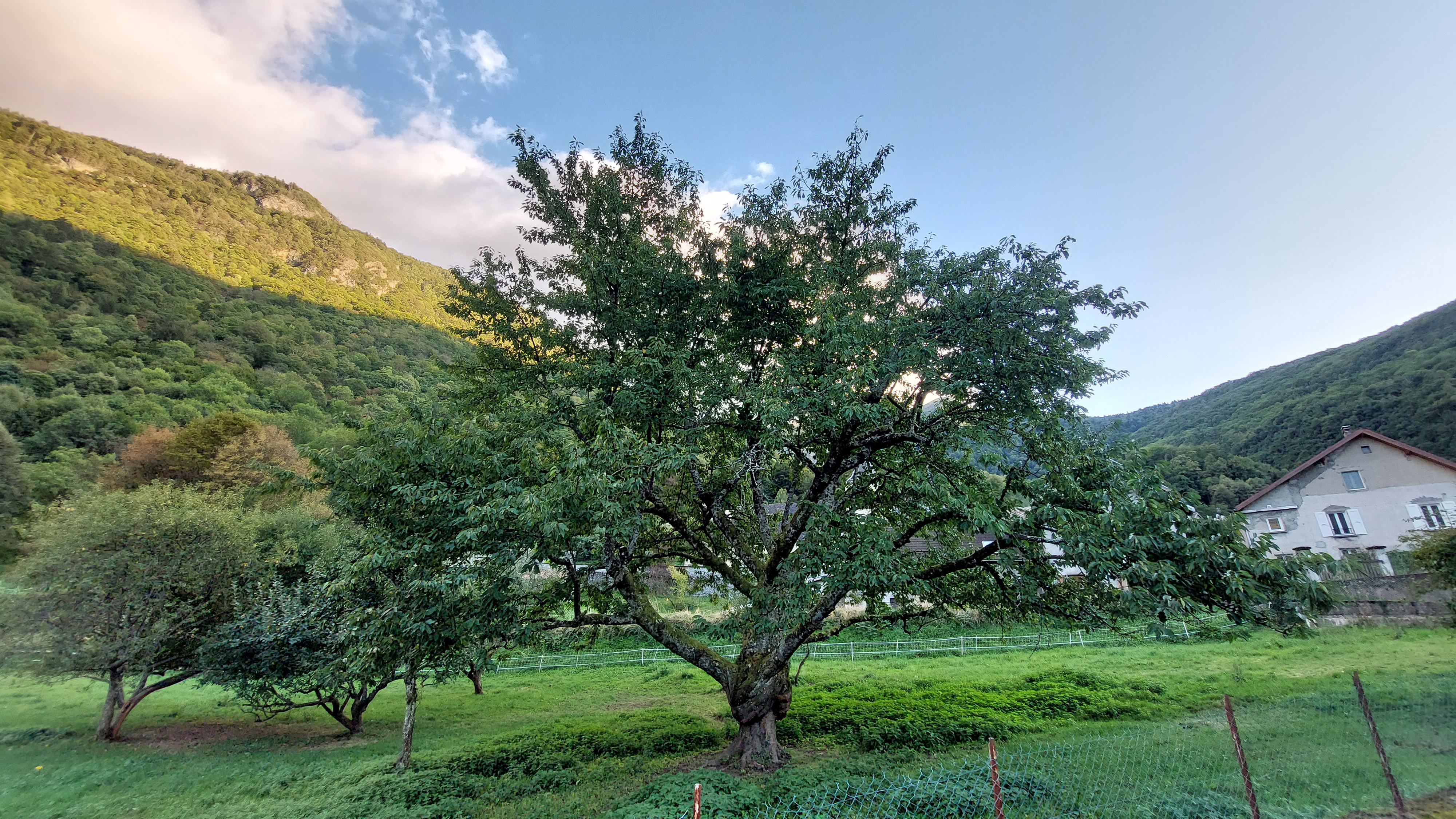
Greetings to all OSM contributors, I have finally found some time to share my mapping party report. I wrote it in English and French. This mapping party was held in France near Grenoble, in a village called Saint-Barthélemy-de-Séchilienne. There were 8 of us who participated in this mapping event.

Saint-Barthélemy-de-Séchilienne

For the report, I wrote some scripts: a bash script that uses the osmosis command to extract the following metrics like : number of roads, tracks, roads with names, alleys, shops, libraries, buildings, …, see the full list in the report.

The idea of this script was to download the data of the city/village before the mapping party and run the script on the resulting osm file. Then, do the same after the mapping party to see how many objects were added. Info about my script can be found here

See full entry

Posted by gvwaal on 6 November 2023 in English.

It is now cold out and also dark, which bodes poorly for finishing this project in a timely manner, because biking when it’s cold and dark isn’t fun. I was not able to achieve my goal of finishing this project by first snowfall (we got 1.8 in [4.6 cm] on Oct 31), but I’m not taking this to heart because a lot of my time the past several weeks has been spent with higher priority things.

Today I was able to finish two streets in about 30 minutes, which is great! These were some of the longer streets in Greater Longfellow, so the pace will be quicker from here on out, most likely due to there being less clutter obstructing my view.

Intro

Part 2

Part 3

Part 4

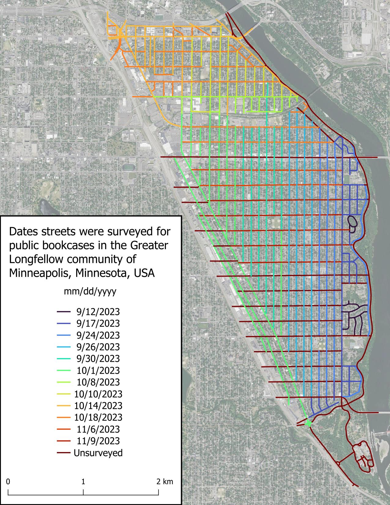
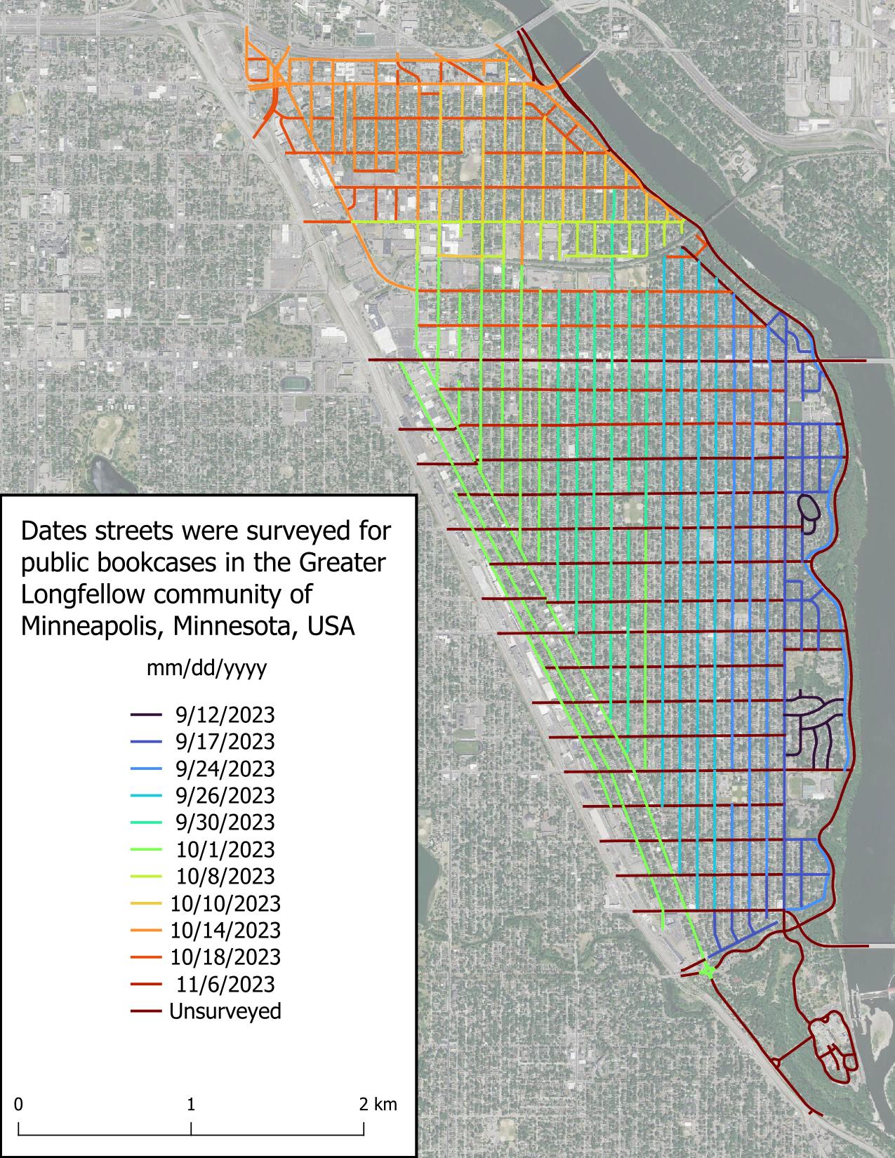
Figure displaying dates roads were surveyed in the scope area. Roads are colored based on date, with the earliest date, 2023-09-12, in very dark blue and grading to red for unsurveyed roads.

Posted by Xvtn on 6 November 2023 in English.

I’ve found it very enjoyable to record and upload GPS traces as I do various activities. These can help with assessing imagery offsets, route accessibility and popularity, adding brand new routes, and as a refresher after I get back from a walk, hike, bike ride, or drive. Here are some questions, issues, etc. I’ve been thinking about. Feel free to comment on any or all:

See full entry