Users' Diaries

Recent diary entries

Posted by Zverik on 21 July 2022 in English. Last updated on 23 July 2022.

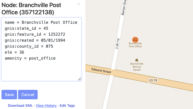
After my last State of the Map talk, some asked me where’s that “Edit Tags” button on the osm.org website, to quickly fix any tags without launching Level0? Of course there wasn’t one: I just quickly made up a text area with Firefox developer tools. But the idea was there.

Now I’m proud to show you that the button works, with a series of changesets to prove it. Alas, not in the website itself: to enable it, you must install a browser extension. Get yours for Firefox or for Chrome. After installing, open the iD editor once, and then look at any object page on osm.org.

This extension is a hack. It uses some undocumented things and will break when something changes in the code. Like, you need to first open iD editor for the authentication to work. If you don’t see the “Edit Tags” link, refresh the page. It is flimsy, but you can edit the map with it.

See full entry

Posted by evgeniyakz on 20 July 2022 in Russian (Русский).

Увидел карту https://www.openhistoricalmap.org

и не смог понять как она работает , наверное много баз данных по числу годов , каждая база рез ботов берёт в викидаты , скрины и переводит по локальным местам . Работает медленно ,наверное надоть установить локальный сервер с зеркалом .

Hi mappers! I have been on holiday near Como Lakes for the last few days. I visited the Forte Montecchio Nord, an old WW1 Fort really well preserved.

I like fortifications and I decided to re-map it, because the old work was fairly approximate. I also add a lot of information (contacts, opening hours…), that’s the result:

Before

The fort before

After

See full entry

Location: Stallone, Erbiola, Curcio, Colico, Lecco, Lombardy, 23823, Italy
Posted by ivanbranco on 19 July 2022 in Italian (Italiano). Last updated on 28 May 2025.

Alcuni dei progetti che porto avanti:

MapRoulette

Posted by плигаюча жабка on 19 July 2022 in English.

To my horror, I recently discovered I’ve misunderstood public transport route rules.

Now I’m sort of undoing some of the changes I’ve been painstakingly adding for the last week. Good grief.

So.

Things to have in mind:

  1. stops are the most important thing. and they have to be in order
  2. routes must be separate for separate directions
  3. roads are a bonus, but sometimes unnecessary to a transport route. (they are visually shown on maps, however)
  4. backwards/forwards direction in route planing is a scam. nobody needs it, so it might as well remain blank. why add it to technical options tho? idk. sigh

Where to look for more info:


that was a cry of a novice. If someone is interested in adding public transport, esp in Ukraine, please, dm me :)

Posted by Kento Kei on 19 July 2022 in English.

Given I rarely do these ‘diary entries’ and all I do is blabber on something barely anyone will care about, It’s time to talk about something more important than a random small town.

Basically, now that I have the ability to fully use JOSM, I am now in a place where I can begin to add large scale land use. I’ve decided to begin a test, and that’s to try to see how much land use I can add in a limited amount of time. Hopefully, from there, it will allow me to begin the actual big part of this whole entry;

I am planning on adding the natural land use (forests, farms, lakes, etc.) of southern Illinois. Not sure how far I’ll get, but if I can at least get the major counties done (Madison, St. Clair, and Jackson), I’ll call it a win.

Posted by Cascafico on 19 July 2022 in Italian (Italiano). Last updated on 14 August 2022.

Data

Recently Microsoft released global building footprints in ODbL.

Quality

I’ve found some challanging situations:

Test

I made several test and some local imports, taking in account in priority order:

  • not overwrite mapper manual work
  • keep consistent highway network
  • check parallax false footprints
  • simplify wherever possible
  • overall offset if needed (Strava and GPS OSM repo references)

Preveza Case study

The town is a compendium of above quality problems. Some imagery spots are burnt by the sun and consequent low contrast was oddly computed by MS algorithms. It took about 5 hours to adjust footprints (and several highways). I applied the following workflow:

  • data cropped by Preveza landuse=residential
  • objects below 60 square meters filtered out
  • object touching OSM buildings filtered out
  • overlapping polygons manual fix
  • manual rotation adjustments on many object (AI problem)
  • highway adjusted by Stava heatmap

Tools

Qgis for initial conversion, crop and filtering. JOSM for offsets, rotations, ovelapping fixes.

오픈스트리트맵에서 ‘행정 구역’을 나타내는 방법

  • boundary=administrative 태그로 나타냅니다.
    • admin_level=2 (국가)
    • admin_level=4 (광역자치단체. 광역시, 도 등)
    • admin_level=6 (기초자치단체. 시, 군, 자치구.)
    • admin_level=7 (자치구가 아닌 구. 일반구)
    • admin_level=8 (읍, 면, 동, 가)
    • admin_level=10 (리, 통)

※ 일부 국가에서는 admin_level=11을 사용하기도 합니다. 한국도 반을 나타내는 데 해당 태그를 사용할 수 있겠지만, 현실적으로 반의 영역은 쉽게 알 수 없기 때문에 현재로서는 admin_level=11을 도입할 필요성은 높지 않아 보입니다.

오픈스트리트맵에서 ‘중심지(시내, 읍내)’을 나타내는 방법

도시

  • place=city 태그로 나타냅니다.
    하위 태그:
    1. place=borough: 아래의 suburb와 유사하지만 행정 구역의 의미가 강합니다. 현재 한국에서는 자치구와 일반구로 사용하고 있습니다.
    2. place=suburb: 도시의 큰 구획입니다.
    3. place=quarter: 도시의 중간 구획입니다. 현재 일부 지구에 사용됩니다.
    4. place=neighbourhood: 도시의 작은 구획입니다. 현재 일부 동에 사용됩니다.

※ 각 구획은 (국가에 따라) 행정 구역일 수도 있고, 아닐 수도 있습니다.
※ 구획의 경계는 명확하지 않을 수 있고, 서로 겹칠 수도 있습니다.
※ 시내/읍내의 규모에 따라 suburb-quarter-neighbourhood 중 일부를 적절히 생략할 수 있습니다.

시골

  • place=town(읍/면소재지 크기), place=village(리의 중심지 크기) 태그로 나타냅니다. 현재 place=town을 구에 사용하는 경우가 간혹 있는데, 읍소재지 크기의 소도시에 적절한 태그라는 점을 고려하면 구에는 위에서 언급한 place=borough를 사용하는 것이 적절해 보입니다.
  • 리의 중심지보다 작은 자연마을에는 place=hamlet을 사용할 수 있고, 한두 가구만 있는 작은 주거지에는 place=isolated_dwelling을 사용할 수 있습니다.

※ 시내/읍내의 규모에 따라 suburb-quarter-neighbourhood 중 일부를 적절히 생략할 수 있습니다.

그렇다면 ‘군’은?

  • place=county로 나타내지만, 해당 태그는 단순히 토지 경계를 나타내는 용도지, 인구 밀집지를 나타내는 용도의 태그가 아닙니다. 실제로 한국도 동 없이 읍면만으로 군을 구성한다는 점을 고려해 보면 어느 정도 맞아떨어집니다.
  • 그렇다고 군에 place=city 태그를 넣기에는 마땅히 넣을 장소가 없고(군청소재지와 그렇지 않은 읍의 인구 차이가 거의 없음, 읍에 place=city를 붙이기에는 체급이 너무 작음), place=town은 이미 읍면에 사용하고 있습니다.
    • 시에는 읍에도, 면에도 속하지 않는 동이 있기 때문에 그 자리에 place=city를 넣을 수 있습니다.
  • Place=city, town, village를 행정 구역의 의미보다는 인구 밀집지의 의미로 보면 왜 OSM Carto에서 군을 눈에 잘 띄지 않게 렌더링하는지 이해할 수 있습니다.

태그의 본래 정의에 맞추기 위한 제안

See full entry

之前好像没有人发布过这样的东西,我就仿照已有的线路做了个preset,已经用了一段时间了。刚刚再参考了其他人的preset,用了value_template,这样连自动模板补全功能都有了。

需要的朋友可以通过这个链接下载: https://notabug.org/vimacs/osm-stuff/src/master/bjbus_preset.xml

Posted by Rouge52 on 16 July 2022 in Italian (Italiano).

Viaggio dal 28 aprile al 22 maggio 2022 Imbarco a Calais per Dover, sosta in parcheggio camper vicino a Canterbury quindi dopo circa 600 km al porto di Fishguard e dopo circa 4 ore di traghetto finalmente in Irlanda a Rosslare. Tappe successive: Cork, Waterville, Killarmey, Doolin ( imbarco per visita isole Aran) Galway poi visita in Irlanda del Nord con le città di Derry, Belfast rientro in Irlanda del sud con la piacevole visita dì Dublino quindi rientro in Italia dopo aver attraversato Gran Bretagna e Francia km totali circa 6000 Ciao a tutti

Location: 44,339, 7,486

Problem: Map a large volume of something that has distinct color.

Solution » High Level: * Highlight a sample square * Send a wanderer around in a perimeter * When the barrier is crossed, stop * Have the end user review

Solution » Low Level [LONG]: public main { //Describe sample square Let the user draw a square //Use sample square int minR, maxR, minB, maxB, minG, maxG; set all the mins to max value and all the max values to 0

for(every pixel in the square)
{
	does it need to be change one of the above 6 ints?
}

//Explore
while(endCondition not triggered)
{
	walk around the perimieter and send it to addSquare()
	if the addSquare says add it, send it to approvedSpots[][]
	else
	{
		ignore it
		but in future versions subdivide the square into 4 areas recursivley to minSizeOfArea;
	}
}

//Encase the area
Find our approved area and go to the top most point from the center.
Drop a point down
Go through the area, if 2 points are on the same line and not necessary, delete it. }

bool addSquare(all 6 rgb values, satteliteArea[][]) { //Filter out the blatantly false average out satteliteAreaRGB if satteliteArea violates the 6 rgb areas, return false.

//Check the square
for all the pixels, how many don't belong
percentDontBelong=numberDontBelong/howmany are in the satteliteArea
    Send it }

Concerns you might have: 1. Automation in OSM? The human has to: Define the sample and approve the result. 2. Junk Data: This would be a problem with a userbase, not a computational problem. We merely create tools. 3. What about non-90 degree angles? I agree that this would be a problem, I would hope someone made a tool that acts like the blender sculpt brush of smooth and bump, but for OSM.

See full entry

Location: Jackson Township, Shelby County, Iowa, United States
Posted by pnorman on 13 July 2022 in English.

Dear all,

Today, v5.5.1 of the OpenStreetMap Carto stylesheet (the default stylesheet on the OSM website) has been released. Once changes are deployed on the openstreetmap.org it will take couple of days before all tiles show the new rendering.

The one change is a bugfix to the colour of gates (#4600)

For a full list of commits, see https://github.com/gravitystorm/openstreetmap-carto/compare/v5.5.0…v5.5.1

As always, we welcome any bug reports at https://github.com/gravitystorm/openstreetmap-carto/issues

Posted by sahilister on 12 July 2022 in English. Last updated on 16 July 2022.

Chandigarh is a planned city here in north India. Since being well flocked by mappers and easy (fun) grid layout of roads, most of the areas are already mapped here. Last month, I came to the realization that many schools and colleges weren’t exactly mapped here.

There are a total of 115 government schools in Chandigarh (Primary-8, Middle-13, High School-53, Senior Secondary-40), seven aided schools, 37 recognized Senior Secondary private schools, 19 recognized private High Schools, 13 recognized private Middle Schools, 6 recognized private primary schools, and 3 recognized private play schools.

From - List of schools in Chandigarh - Wikipedia

The Wikipedia entry told me that there were quite a lot of work to be done, so I got to work. Got a todo list from Department of Education, Chandigarh Administration’s website. [1][2][3] I came to the realization vast majorities of school areas were already mapped and marked amenities=school some 9-10 years ago by Oberaffe, just that those lacked associated names and information of the institutions. Now getting the sector from DoE’s website and location from https://chandigarh.gov.in/know-chandigarh/map and referencing from Bharat Maps (which, by the way have surprisingly good mapping of schools), got me mapping. I just search for the school’s website and Wikipedia page, if it exists, and usually add the following tags -

  • name
  • name:en
  • alt_name
  • alt_name_1 (sometimes alt_name_2 also)
  • amenity
  • operator - usually educational societies
  • religion
  • website
  • phone
  • email
  • fax - weirdly, some schools still advertise them
  • grades - using 0-12 format where 0 signify pre-school - nursery/LKG/UKG
  • addr:postcode
  • addr:city
  • wikidata
  • wikipedia
  • source - which is usually website

See full entry

Location: Sector 22, Ward 3, Chandigarh, India
Posted by villasv on 12 July 2022 in English.

Today I was ables to swap out the pairing of OSM nodes and VSI stores. I’m now going over each VSI store and picking the closest OSM node with no threshold. Well, I am using a soft cap threshold of 1 km just to guarantee that the cross product of these two tables won’t explode, but no VSI store stays unmatched with that radius.

The analysis can be seen in this Data Studio dashboard.

As of now there are 140 good looking matches between OSM and VSI, basically half the dataset - much more than the initial count of 10%! I’ll go through these manually anyway just to confirm, because a few of them have a bit of a location discrepancy (>50 meters) and many have noticeable naming variations.

There are 138 non-matching pairs. There are a few of these that are just being missed by the name matching fuzziness logic, but most do seem to have significantly different names and locations. These will require a bit more survey work to sort out.