 OpenStreetMap

On 11 December 2012 LionMapperTeam Nsukka, in collaboration with UniqueMapperNetwork Nigeria, hosted a webinar on Volunteerism and Membership, Talking about Volunteerism a person who works for an organization without been paid for it, because they want to do it. A volunteer is someone who offers to do a particular task or job without been forced to do it. A volunteer Member is a person who is or has been designated by the governing board of an organization and who is faithfully and actually performing volunteer service in that organization. example of a Volunteer Member@ UniqueMapperNetwork, LionMapperTeam, YouthMapperNetwork etc. THE BENEFIT OF VOLUNTEERISM can never be overemphasis it opens opportunities, it Connect you to friends and experts, Create networking, Resume and CV advantage, improve professionalism and develop skills(Soft and Hard skills) expose individual to different skills, give one the advantage of presenting at different summit, workshop, training and seminar.
Users' Diaries
Recent diary entries
Today been 27 November 2021, I lead a talk with a team of Lion Mapper Nsukka, Nigeria. on the discuss of OpenStreetMap and HOT Tasking Manager as a tool for free open data mapping and it is free user approach for individual and organizations. OSM and HOT came into existence as an open data source due to lack of data availability about a location, on how to solve environmental issue was a challenge in the 80s. Created in 2004 by Steve Coast in the UK, who initially focus on mapping United Kingdom to help in free and widely distribution of data for everyone to use. OSM is a community owned and supported by OpenStreetMap foundation located in England and Wales. OSM provides geographic data with over 2 million users across the world. OSM and HOT Tasking Manager is open for volunteerism, were Mappers and individual can team up to contribute to open data mapping of their community by providing information about an unknown location via mapping (Mapathon) to be known. Volunteers here in OSM and HOT Tasking Manager help to contribute in open data mapping about disaster management and response of a location, were in turn aid disaster response team and organization to have access to that particular location. Data is save in OSM and HOT Tasking Manager database for future use by Government, NGOs and private organization who are thrilled and concern about the human and natural environment in response to any disaster or environmental challenge about a place which require a location based information.

Strava has recently published its annual report. Like last year it reports a huge increase in users - globally 2 million people join every month, here in the U.K. 17% of the population now use the app. I can’t find a thank you to OSM mappers in the report but nevertheless I think we can take a lot of the credit for its success. The app and all its runners, walkers and cyclists are dependent on the paths and roads that we have mapped and are still mapping. They must surely be one of the biggest groups of OSM users.

My location of home.

Bonjour,
Quels sont les points forts et ppoints faibles de Openstreetmap ? Quelle est son utlisation ? Quel est le type de scr utilisable dans cet outil ? Ppeut-ont ouvrir des shapefils dans cette interface ?
Merci bien à vous
Marie Cath
ฉันขอให้เพื่อนนะนำ ให้ฉันด้วย
J’ai entamé un travail de mise à jour dans OpenStreetMap des arceaux à vélo de la métropole de Lyon. Il reste beaucoup à faire.
À cette heure je compte 4.091 objets dans le jeu de la métropole versus 3.351 dans le jeu OpenStreetMap. Après analyse le greffon Conflation de JOSM annonce ces chiffres :
- 2.846 correspondances, avec des écarts allant jusqu’à 40 mètres (la limite que j’ai fixée pour le rapprochement)
- 1.245 objets présents uniquement dans le jeu de la métropole
- 505 objets présents uniquement dans le jeu OpenStreetMap
Quand les positions correspondent et que c’est pas déjà renseigné, j’ajoute systématiquement la référence (le champ “nom” du jeu de la métropole) en tant que ref:FR:GrandLyon. Ceci permettra un rapprochement plus fiable par la suite.
Positionnement : Pour les objets que j’ai traités, l’erreur de positionnement se situe parfois dans les données OpenStreetMap, parfois dans les données Métropole, voire parfois dans les 2. Quand les arceaux étaient visibles j’ai recalé les positions dans OSM. J’ai laissé une note=positionnement corrigé par rapport à l'open-data en espérant que ça remonte peut-être un jour à la métropole. Et pour éviter qu’à chaque comparaison on se demande qui a raison. Malheureusement je ne l’ai pas fait au début et il en manque. Je referai une passe.
Suppressions : Il y a des arceaux qui disparaissent suite à des réaménagements de voirie. Ils sont supprimés du jeu Métropole mais ils sont encore présents dans les données OpenStreetMap. Quand j’ai un doute je laisse un fixme=resurvey, que je double avec une note demandant de confirmer si les arceaux existent encore. Ça peut faire doublon mais le fixme est plus facile à utiliser pour les requêtes, tandis que la note est plus visible pour les contributeurs qui sont sur le terrain.
Nova dalnice jaromer Hradec Kralove je jiz otevrena
日本国内の市町村内にある町名・字名(以下、地名とします)の登録がほとんどの市町村において完了しました。
国内の地名の登録は2012年頃から位置参照情報(以下、ISJ)のインポートという形で始まったようです。 osm.wiki/Import/Catalogue/Japan_ISJ_Import
その後長く動きはなかったようですが、nyampireさんのISJ 2019のインポートが2021年に動き始めました。 osm.wiki/JA:MLIT_ISJ/import2019_outline
私は2019年にOSMを始め、地図に地名さえ載ってないのは寂しいな、使いづらいなと思っていたので、当初から少しずつ地理院地図のトレースという形で地名の登録を始めました。 しかし、地名の手入力というのは果てしなく時間がかかるものです。
ということで、ISJ 2019のインポートが始まってからほどなくして、私もそのインポート作業をお手伝いすることにしました。 そしてようやく2021年11月に5つほどの市を除く全市町村への位置参照情報掲載の地名を登録終えました。
そのインポート作業をする中で、いくつかのエリアで新たな町名ができたことを知ります。 そして、新町名の情報をネット検索すると、出るわ出るわ、結構あちこちでしているようです。 要因としては住宅地が新たにできることで住居表示の実施をしたり、区画整理や町界町名整理などに伴う、新町名の設定などがあります。
そこで、概ね2018年以降設置された新町名について、その項目と地理院地図やISJ、OSMへの登録状況をまとめてみました。 osm.wiki/JA:Chimei_placename
これを見るとISJや地理院地図にいつ頃の分まで登録されているなとか、抜けているのもあるなということが見えてきます。 当面はこのリストを元にOSMへの地名の登録あるいは確認を行うことで、最新情報を保っていきたいなと思います。

The street complete app makes filling out data for OSM really fun. This was unexpected. I thought it was just going to be a more convienent way to enter data, but it’s also oddly satisfying.

Don’t forget to get some of your only one 🕜

La collecte de la donnée avec KOBO, facilite l’obtention de beaucoup d’information sur l’objet à collecter et cela dépend de ce qu’on veut avoir comme information. La localisation du lieu de la collecte est encore mieux quand on veut faire les analyses spatiales sur les informations.
En effet, l’insertion du langage OSM dans le paramétrage de Kobo, simplifie largement la marche à suivre pour placer les informations sur le point collecté dans OSM. Jusqu’ici on convertissait les données en XLS ou CSV, puis on faisait des tris sur les colonnes utiles, on ajoutait les tags osm et en fin on envoyait à osm.
Avec le téléchargement des données dans le langage OSM, ça facilite l’envoi à OSM après quelque contrôle qualité, parce qu’envoyer les données à OSM, nécessite toujours une vérification pour éviter la duplication avec les données existantes. Je pense que KOBO va ainsi nous aider à gagner le temps de travail.
Ma curiosité a finalement été éclairée lors de la démonstration faite par Zack et Peter lors de « State of the map africa » le 20 novembre dernier sur l’utilisation du langage OSM dans KOBO, j’aimerais bien essayer ça moi-même dans la communauté pour voir le succès de cette facilitation. Si quelqu’un l’a bien compris c’est cool pour moi qu’on échange là-dessus. Ne l’oubliez pas, je suis plus à l’aise en français qu’en anglais.
Using Kobo Toolbox for OSM mapping
Collecting data with KOBO makes it easier to obtain a lot of information about the object to be collected and it depends on what you want to have as information. The localization of the place of collection is even better when we want to make spatial analyses on the information.
Indeed, the insertion of the OSM language in the Kobo settings greatly simplifies the process of placing the information about the collected point in OSM. Until now, we converted the data into XLS or CSV, then we sorted the useful columns, added the osm tags and finally sent them to osm.
%20by%20Vince%20Emond.jpg)
Hi all,
Some of you may remember earlier this year we conducted an experiment to compare traditional mapping with ai-assisted mapping. Below is our summary of findings and the full report for those who may be interested. We hope this experiement will be the start of the conversation of how we can ethically and responsibly introduce AI augmented mapping workflows into HOT’s work in 2022.
Humanitarian OpenStreetMap Team, comparison of traditional digitizing of building features in OpenStreetMap of machine learning assisted building digitization
Key findings:
- Although most participants were new to AI-assisted mapping, the majority of participants were open and likely to integrate it into their workflows.
- For beginner mappers, AI-assisted mapping drastically increased their mapping speed, but had no significant effect on their quality
- For advanced mappers, after a small mapping slow-down, AI-assisted enabled more efficient mapping without impacting their quality
- Open models offer significant potential impact and value for humanitarian response
- More data created through AI-assisted mapping may exacerbate the ‘validation bottleneck’
In the last 10 years, the use of AI/ML in the geospatial sector has boomed. Private sector, academic and nonprofit organizations alike have been investing significant thought, time and resources into exploring and testing the potential and possibility of how AI/ML can augment and amplify current GIS workflows.
Unfortunately for the open mapping community, a ‘go fast and break things’ approach has done exactly that, often coming at significant cost to the project and the community. As a result, open mapping communities are reluctant to allow unchecked AI/ML to roam free in the world that is OSM - created and crafted by countless hours of dedicated human mapping.

What I did in OpenStreetMap in November 2021

เมื่อวันที่ 5/12/21 Mechanic ซ่อมบางอย่างนวมทั้ง เีเจชื่อดัง สนใจเรื่อง โดรน และขอซื้อในราคาสูง เจรจาต่อรองเพียงคนเดียว เหมือนไม่ให้ก็ต้องให้ในวันนั้น จนถึงวันนี้ รอสัณญาเงิน
ซ่อมทุกส่วนสำเร็จแล้ว ….ชาาง ซ่อมโลกทางใต้…✍️ 🙏

Today the OSMF board made the expected decision to formally roll out the behavior control regime that has been in the making for quite some time on the talk and osmf-talk mailing lists. Nothing surprising here - i have commented on the larger topic before.
As i have written in my previous commentary, creating communication channels where participants are protected from being exposed to cultural and personal communication style diversity beyond what they are able and willing to deal with is fine - and actually desirable. That for this purpose existing communication channels are repurposed is a bit rude, but that is something we can deal with.
The news is that the board in their decision also includes the intention to extend the behavior control regime to all international communication channels hosted by the OSM Foundation. While this has been the expressed desire of those pushing for community management and behavior control in OSM all along, this is the first time the OSMF board has actually indicated they intend to adopt this idea of a totalitarian behavior control system - not only creating spaces for those who are unwilling or unable to tolerate behavior diversity outside their personal and cultural standards, but projecting these standards on everyone and declaring them to be binding for everyone, everywhere within the domain controlled by the OSMF. This is not unexpected, given past articulations and actions from the board, but it is still sobering to see that becoming definitive - in the form of a formal decision - without any critical discussion or reflection on what that means.
For me it has been clear from the beginning that i will not subordinate myself to the behavior standards of someone else when contributing to what is an endeavor of egalitarian cross cultural cooperation like OpenStreetMap. Especially not if the codifications of those standards are written down in a way that is as vague as what has been adopted by the OSMF board now.
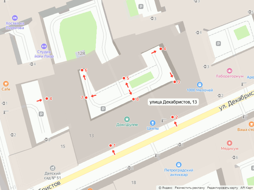
Интересно, откуда у Яндекса данные по подъездам? Некоторые тут говорят, какие у них замечательные данные. Действительно, часто их данные с реальностью совпадают, или в них можно найти лишь мелкие отличия. Но иногда их данные к реальности имеют отдалённое отношение.
Только что ввёл дом: из девяти входов у меня с Яндексом совпадают два (№1 и №7, ну можно засчитать ещё №2, если не смотреть на него относительно арки).

First of all what a great set up by the state of the map committee.
I must say, before the conference I wasn’t quite aware of all the partners OSM was in collaboration with, it seems like it all goes well beyond just mapping.
Of great interest was the content density of OSM in Africa and the lack of map content that has resulted over the years and that can be particularly attributed to the lack of technological advancements especially for Africa.
Great idea by Isla from the use of offline spaces and technology to sort of overcome the lack of internet connectivity when one seeks such services.
The importance of free and open source software is indeed an important aspect of mapping, from the presentation it’s quite clear why open source software is essential in an effort to overcome some of the already existing challenges that mappers face.
Well I’ve used some of these open source software like QGIS, and ArcMap which was unfortunately not free and open source software. Great innovation from the OSGeolive where users can change the user language making it usable to most mappers irrespective of their language.
Quite an eye opener from the use of AI generated buildings and manual tracing. To share a personal opinion, data quality is key in all these aspects to ensure quality analysis by any user who wishes to use this OSM data
From the presentation on the journey towards building a sustainable OSM community in Malawi, I was particularly concerned about my country of origin (Eswatini formally known as Swaziland) as from browsing on the OSM website, it seems like very few Eswatini mappers contribute to this initiative.
The challenges highlighted in the presentation including disaster and risk management were pointed out on their solutions including population data which can help locate people at risk in cases of such natural disasters such as volcanic eruptions. At last I saw a somehow familiar face, Geoffrey😇

I am Lineekela and I am quite new to the OSM community but I have GIS experience and background as I am a GIS graduate. I started OSM this year (2021) where I took part in the Mapathorn here in Namibia and later was part of the team that facilitated the mapathorns.
This is my first time attending the “State of the Map Africa 2021” event. I could only attend the first day but I watched the recorded sessions on YouTube so I could update myself on what I have missed out on.
From the videos I have watched, I have learned quite a lot about the open source software and their tools that can be use when it comes to spatial data. I have learned about OSGeoLive and the tools that are available like GeoNode which is an SDI for sharing and managing spatial data. QGIS whas also talked about, but I have already known about it as it is the software I use when creating maps and cleaning GPS data. Another thing I found interesting was the journey towards building a sustainable OSM community in Malawi as we here in Namibia are currently busy trying to establish a community here in Namibia aswel. We have started in April 2021 with Mapathorns where we trained community members how to digitize their respective settlements that they were familiar with. I am looking forward to the next State of the Map Africa event so I can share my experiences and learn from my fellow mappers as well.

🏡44/18 หมู่. 1 ตำบลหนองรี อำเภอ เมืองชลบุรี จังหวัด ชลบุรี 20000