Users' Diaries

Recent diary entries

La collecte de la donnée avec KOBO, facilite l’obtention de beaucoup d’information sur l’objet à collecter et cela dépend de ce qu’on veut avoir comme information. La localisation du lieu de la collecte est encore mieux quand on veut faire les analyses spatiales sur les informations.

En effet, l’insertion du langage OSM dans le paramétrage de Kobo, simplifie largement la marche à suivre pour placer les informations sur le point collecté dans OSM. Jusqu’ici on convertissait les données en XLS ou CSV, puis on faisait des tris sur les colonnes utiles, on ajoutait les tags osm et en fin on envoyait à osm.

Avec le téléchargement des données dans le langage OSM, ça facilite l’envoi à OSM après quelque contrôle qualité, parce qu’envoyer les données à OSM, nécessite toujours une vérification pour éviter la duplication avec les données existantes. Je pense que KOBO va ainsi nous aider à gagner le temps de travail.

Ma curiosité a finalement été éclairée lors de la démonstration faite par Zack et Peter lors de « State of the map africa » le 20 novembre dernier sur l’utilisation du langage OSM dans KOBO, j’aimerais bien essayer ça moi-même dans la communauté pour voir le succès de cette facilitation. Si quelqu’un l’a bien compris c’est cool pour moi qu’on échange là-dessus. Ne l’oubliez pas, je suis plus à l’aise en français qu’en anglais.

Using Kobo Toolbox for OSM mapping

Collecting data with KOBO makes it easier to obtain a lot of information about the object to be collected and it depends on what you want to have as information. The localization of the place of collection is even better when we want to make spatial analyses on the information.

Indeed, the insertion of the OSM language in the Kobo settings greatly simplifies the process of placing the information about the collected point in OSM. Until now, we converted the data into XLS or CSV, then we sorted the useful columns, added the osm tags and finally sent them to osm.

See full entry

Location: Butembo, Kimeni, Butembo, Nord-Kivu, République démocratique du Congo
Posted by bo_hot on 16 December 2021 in English. Last updated on 17 December 2021.

Hi all,

Some of you may remember earlier this year we conducted an experiment to compare traditional mapping with ai-assisted mapping. Below is our summary of findings and the full report for those who may be interested. We hope this experiement will be the start of the conversation of how we can ethically and responsibly introduce AI augmented mapping workflows into HOT’s work in 2022.

Humanitarian OpenStreetMap Team, comparison of traditional digitizing of building features in OpenStreetMap of machine learning assisted building digitization

Key findings:

  • Although most participants were new to AI-assisted mapping, the majority of participants were open and likely to integrate it into their workflows.
  • For beginner mappers, AI-assisted mapping drastically increased their mapping speed, but had no significant effect on their quality
  • For advanced mappers, after a small mapping slow-down, AI-assisted enabled more efficient mapping without impacting their quality
  • Open models offer significant potential impact and value for humanitarian response
  • More data created through AI-assisted mapping may exacerbate the ‘validation bottleneck’

In the last 10 years, the use of AI/ML in the geospatial sector has boomed. Private sector, academic and nonprofit organizations alike have been investing significant thought, time and resources into exploring and testing the potential and possibility of how AI/ML can augment and amplify current GIS workflows.

Unfortunately for the open mapping community, a ‘go fast and break things’ approach has done exactly that, often coming at significant cost to the project and the community. As a result, open mapping communities are reluctant to allow unchecked AI/ML to roam free in the world that is OSM - created and crafted by countless hours of dedicated human mapping.

See full entry

Location: Le Mont Gosse, Monnetier-Mornex, Saint-Julien-en-Genevois, Upper Savoy, Auvergne-Rhône-Alpes, Metropolitan France, 74560, France

เมื่อวันที่ 5/12/21 Mechanic ซ่อมบางอย่างนวมทั้ง เีเจชื่อดัง สนใจเรื่อง โดรน และขอซื้อในราคาสูง เจรจาต่อรองเพียงคนเดียว เหมือนไม่ให้ก็ต้องให้ในวันนั้น จนถึงวันนี้ รอสัณญาเงิน

ซ่อมทุกส่วนสำเร็จแล้ว ….ชาาง ซ่อมโลกทางใต้…✍️ 🙏

Location: 18.945, 71.995
Posted by imagico on 15 December 2021 in English.

Today the OSMF board made the expected decision to formally roll out the behavior control regime that has been in the making for quite some time on the talk and osmf-talk mailing lists. Nothing surprising here - i have commented on the larger topic before.

As i have written in my previous commentary, creating communication channels where participants are protected from being exposed to cultural and personal communication style diversity beyond what they are able and willing to deal with is fine - and actually desirable. That for this purpose existing communication channels are repurposed is a bit rude, but that is something we can deal with.

The news is that the board in their decision also includes the intention to extend the behavior control regime to all international communication channels hosted by the OSM Foundation. While this has been the expressed desire of those pushing for community management and behavior control in OSM all along, this is the first time the OSMF board has actually indicated they intend to adopt this idea of a totalitarian behavior control system - not only creating spaces for those who are unwilling or unable to tolerate behavior diversity outside their personal and cultural standards, but projecting these standards on everyone and declaring them to be binding for everyone, everywhere within the domain controlled by the OSMF. This is not unexpected, given past articulations and actions from the board, but it is still sobering to see that becoming definitive - in the form of a formal decision - without any critical discussion or reflection on what that means.

For me it has been clear from the beginning that i will not subordinate myself to the behavior standards of someone else when contributing to what is an endeavor of egalitarian cross cultural cooperation like OpenStreetMap. Especially not if the codifications of those standards are written down in a way that is as vague as what has been adopted by the OSMF board now.

See full entry

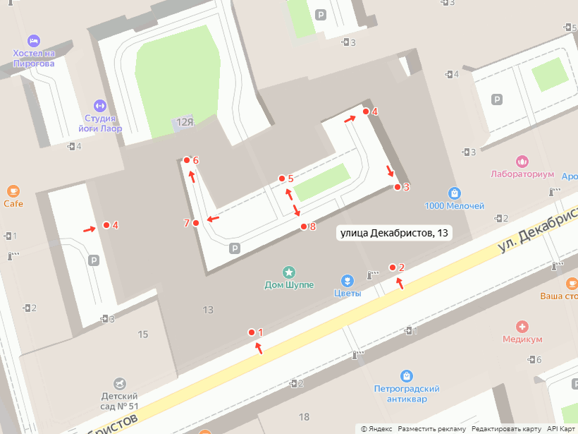
Интересно, откуда у Яндекса данные по подъездам? Некоторые тут говорят, какие у них замечательные данные. Действительно, часто их данные с реальностью совпадают, или в них можно найти лишь мелкие отличия. Но иногда их данные к реальности имеют отдалённое отношение.

Только что ввёл дом: из девяти входов у меня с Яндексом совпадают два (№1 и №7, ну можно засчитать ещё №2, если не смотреть на него относительно арки).

скриншот дома с подъездами из Яндекс-карт

See full entry

Posted by kolunga_m on 14 December 2021 in English.

First of all what a great set up by the state of the map committee.

I must say, before the conference I wasn’t quite aware of all the partners OSM was in collaboration with, it seems like it all goes well beyond just mapping.

Of great interest was the content density of OSM in Africa and the lack of map content that has resulted over the years and that can be particularly attributed to the lack of technological advancements especially for Africa.

Great idea by Isla from the use of offline spaces and technology to sort of overcome the lack of internet connectivity when one seeks such services.

The importance of free and open source software is indeed an important aspect of mapping, from the presentation it’s quite clear why open source software is essential in an effort to overcome some of the already existing challenges that mappers face.

Well I’ve used some of these open source software like QGIS, and ArcMap which was unfortunately not free and open source software. Great innovation from the OSGeolive where users can change the user language making it usable to most mappers irrespective of their language.

Quite an eye opener from the use of AI generated buildings and manual tracing. To share a personal opinion, data quality is key in all these aspects to ensure quality analysis by any user who wishes to use this OSM data

From the presentation on the journey towards building a sustainable OSM community in Malawi, I was particularly concerned about my country of origin (Eswatini formally known as Swaziland) as from browsing on the OSM website, it seems like very few Eswatini mappers contribute to this initiative.

The challenges highlighted in the presentation including disaster and risk management were pointed out on their solutions including population data which can help locate people at risk in cases of such natural disasters such as volcanic eruptions. At last I saw a somehow familiar face, Geoffrey😇

See full entry

Posted by Kelah on 14 December 2021 in English.

I am Lineekela and I am quite new to the OSM community but I have GIS experience and background as I am a GIS graduate. I started OSM this year (2021) where I took part in the Mapathorn here in Namibia and later was part of the team that facilitated the mapathorns.

This is my first time attending the “State of the Map Africa 2021” event. I could only attend the first day but I watched the recorded sessions on YouTube so I could update myself on what I have missed out on.

From the videos I have watched, I have learned quite a lot about the open source software and their tools that can be use when it comes to spatial data. I have learned about OSGeoLive and the tools that are available like GeoNode which is an SDI for sharing and managing spatial data. QGIS whas also talked about, but I have already known about it as it is the software I use when creating maps and cleaning GPS data. Another thing I found interesting was the journey towards building a sustainable OSM community in Malawi as we here in Namibia are currently busy trying to establish a community here in Namibia aswel. We have started in April 2021 with Mapathorns where we trained community members how to digitize their respective settlements that they were familiar with. I am looking forward to the next State of the Map Africa event so I can share my experiences and learn from my fellow mappers as well.

Location: Windhoek Central, Windhoek, Khomas, 10005, Namibia

Mon Experience State of the Map Africa 2021

FR- version

OSM DRC La 3éme edition du state of the map Africa (SOTMA) c’est tenu du 19 au 21 Novembre 2021 durant trois jours j’ai pu assisté a plusieurs panel et discussion aussi j’ai présenté la communauté OSM RDC durant une session d’échange et aussi assisté claireHalleux sur la session pratique d’edition sur le wiki openstreetmap.

See full entry

Location: Selembao, Kinshasa, République démocratique du Congo

Pour ceux qui ne connaissent pas indoor=, je vous invite à consulter le billet d’introduction. En bref, c’est une carte qui affiche les espaces intérieurs d’OpenStreetmap avec un sélecteur de niveaux.

Indoor= a toujours eu pour but de faciliter le travail des contributrices et contributeurs en ayant des données le plus à jour possible avec la mise à jour horaire des données d’OpenStreetMap. Malgré cette fréquence, il était frustrant d’attendre le rendu plusieurs dizaines de minutes pour se rendre compte d’une erreur.

Pour éviter cette embuche et réduire le temps de retour sur son travail, vous pouvez désormais prévisualiser vos changements sur indoor= avant de les envoyer sur OpenStreetMap.

Le plus simple pour l’utiliser est d’utiliser JOSM. Vous enregistrez vos modifications au format GeoJSON, et vous les envoyez sur indoor=.

Démonstration

Voir la vidéo de démo

On le voit, une fois le fichier sélectionné, une interface spécifique apparait, et il est facile de choisir une nouvelle version pour permettre de corriger ou d’améliorer les modifications.

Précisions, le rendu GeoJSON est une prévisualisation, il ne sera pas le reflet parfait du rendu final:

  • la gestion des caractères latins et non latin des POIs n’est pas géré

  • les surfaces contiguës area/corridor ne sont pas fusionnées

  • certains POIs ne sont pas correctement gérés

  • les performances sont moins bonnes

  • il n’est pas encore possible de cliquer sur les POIs

Essayez la prévisulation dès maintenant !

Si vous trouvez de grosses différences ou pour tout autre retour, n’hésitez pas à créé un ticket sur GitHub.

Posted by François2 on 13 December 2021 in English. Last updated on 14 December 2021.

For those who have never heard of indoor=, you may want to read the introductory blog post. In short, it is a map that displays the indoor data of OpenStreetmap with a level selector.

Indoor= has always aimed to facilitate the work of contributors by having the most up-to-date data possible with the hourly update of OpenStreetMap data. Despite this frequency, it was frustrating to wait several tens of minutes for the rendering to realize an error.

To avoid this hassle and to reduce the time of feedback, you can now preview your changes on indoor= before sending them to OpenStreetMap.

The easiest way to use it is to use JOSM. You save your changes in GeoJSON format, and send them to indoor=.

Demo

View the demo video

As you can see, once the file is selected, a specific user interface appears, and it is easy to choose a new version to correct or improve the modifications.

Note that the GeoJSON rendering is a preview, it will not be a perfect reflection of the final rendering:

  • the management of latin and non-latin characters of POIs is not managed

  • contiguous area/corridor surfaces are not merged

  • some POIs are not correctly managed

  • the performances are less good

  • it is not possible to click on POIs yet

Give it a try!

If you find big differences or for any other feedback, feel free to create a ticket on GitHub.

La 3e édition du sotma a pris fin ce dimanche 21 novembre 2021.

Durant 3 jours, j’ai pu suivre de nombreuses communications aussi diverses que variées.

C’est la première fois que j’assiste à ce genre d’événement OSM.

Cette conférence m’a permis de découvrir des initiatives venant des communautés. Il est très intéressant de souligner qu’il y en a que l’on peut répliquer chez soi. C’est d’ailleurs l’un des avantages avec le projet openstreetmap. Ces trois jours ont été également l’occasion de mapper et de voir le visage des personnes dont on entend parlé ou rencontre les noms.  J’ai aimé le programme et son contenu. Cependant, la majorité des présentations sont en anglais. Cela a été parfois un problème pour moi, des difficultés à interagir.  Je voudrais à cet effet, recommander qu’il y ait des interprètes pour traduire vers les autres langues au cours des prochaines éditions. Je remercie le comité d’organisation pour m’avoir permis d’assister à cette conférence en m’octroyant la bourse.

Location: Tokpa-Zoungo-Nord, Zogbadjè, Abomey-Calavi, Atlantique, Bénin
Posted by dcapillae on 12 December 2021 in Spanish (Español). Last updated on 3 November 2023.

Progreso en el etiquetado de direcciones postales de Málaga entre diciembre de 2009 y diciembre de 2021 Progreso en el etiquetado de direcciones postales de Málaga entre diciembre de 2009 y diciembre de 2021. Fuente: elaboración propia a partir de datos de colaboradores de OpenStreetMap.

Ya es posible buscar en OpenStreetMap por direcciones postales en los distritos municipales de Cruz de Humilladero, Ciudad Jardín, Teatinos-Universidad, Churriana y Carretera de Cádiz, así como en casi todo el distrito Centro, Este y Palma-Palmilla del municipio de Málaga.

Varios colaboradores han contribuido a esta mejora en el etiquetado de direcciones postales, entre otros, Antonio Clavero, Alan Grant, AlviNihon, MrPart, Diec, Leon, Carlos Cámara, Javier Sánchez y Jorge Sanz.

See full entry

Location: 36.721, -4.418
Posted by Cristoffs on 12 December 2021 in Polish (Polski).

Zawsze warto mieć zasady. Dla przypomnienia.

Dekalog edytora.

  1. Projekt OSM to zbiór danych z których korzysta wiele osób i instytucji, między innymi na terenie Polski z sieci drogowej korzysta Straż Pożarna podczas działań ratowniczych. Uważaj więc na swoje działania. Edytowanie mapy nie jest zabawą!
  2. Każdy obiekt istniejący w OSM ma swojego autora, szanuj cudzą pracę zastanów się zanim coś poprawisz lub usuniesz. Nigdy nie kasuj czegoś czego przeznaczenia nie jesteś pewien.
  3. Jeśli zauważysz problem, a nie umiesz go rozwiązać skorzystaj z możliwości dodawania uwag, poproś o pomoc na forum, lub zapytaj na Discordzie.
  4. Korzystaj z wiki.openstreetmap.org dodając tagi - nie zgaduj.
  5. Edytuj wyłącznie na podstawie zweryfikowanych źródeł, które pozwalają na wprowadzenie ich danych do bazy na licencji ODbL (Listę najważniejszych znajdziesz w tym podręczniku,)
  6. Do zmian jakie wysyłasz na serwer dodawaj komentarze oraz źródło z jakiego korzystasz podczas dokonywania edycji. Jeśli dokonujesz zmiany na terenie Polski komentarz może być po po polsku. Jeśli zmieniasz poza granicami lepiej pisać po angielsku.
  7. Bądź dokładny! Wszyscy staramy się, by dane OSM były jak najwyższej jakości.
  8. Każdy może popełnić błąd! Każdą zmianę można wycofać, jeśli coś zepsułeś daj znać pomożemy naprawić.
  9. Zawsze korzystaj z Narzędzia poprawności (Walidatora) staraj się usuwać błędy i sam ich unikaj (Wyjątkiem są Relacje - tych nie dotykaj, jeśli dokładnie nie wiesz co robisz, najlepiej przed edycją to z kimś skonsultować)
  10. Dopilnuj by twój adres e-mail na stronie openstreetmap.org był zawsze aktualny. Dzięki temu inni będą mogli się z Tobą skontaktować.

Editor’s Decalogue.

See full entry

วัดบางพลีใหญ่ใน

Location: บ้านลิขิต, ตำบลบางพลีใหญ่, องค์การบริหารส่วนตำบลบางพลีใหญ่, อำเภอบางพลี, จังหวัดสมุทรปราการ, 10540, ประเทศไทย

My name is Choolwe Hamama, i am an OSM enthusiast based in Zambia. I had the opportunity of attending the 2021 OSM Africa state of the map Conference. This conference provided me with the opportunity to learn about various Open Street Map projects that have been implemented across Africa, as well as to gain new knowledge about Open Street Mapping technologies and to meet and connect with other mappers from across the continent.

The workshops were divided in sessions which helped me better understand various concepts and use of OSM in Africa ranging from different categories such as uses in Local Governments, schools, use of JOSM to Map, use in the Health sector as well as how to contribute to OSM using JOSM.

The meeting went off without a hitch and was a huge success. However, some sessions were a bit long for a virtual conference considering some challenges that we face in Africa, such as load shading and Internet connectivity issues. As result of some of the technical challenges that I faced in my country, I was unable to attend all the sessions of the conference. Furthermore, the technical team has taken a bit long to upload all the recorded session on the YouTube channel, this has made it impossible for people who did not attend the conference because of reasons beyond their control to learn from the conference. It would be preferable for future virtual conferences to look into ways to shorten online meetings as well as to directly record sessions and promptly upload them on YouTube so that participants can review them even after the conference has ended.

Location: Chipata, Kitwe, Kitwe District, Copperbelt Province, 1001, Zambia