Users' Diaries

Recent diary entries

Posted by Monchinho on 11 December 2021 in Galician (Galego). Last updated on 29 December 2021.

Listaxe do que levo feito por concellos:

-Engadidos censos de moitos concellos. Engadidos censos por aldeas e parroquias de Brión e Negreira. Engadidos censos por aldeas de Urdilde e Agrón.

AMES -Revisadas todas as aldeas das parroquias de Ames, Agrón, Covas, Bugallido, Piñeiro, Lens, Tapia e Trasmonte. Varias melloras en todo o territorio.

ARTEIXO -Engadida microtoponimia do Porto Exterior da Coruña.

BAIONA -Engadida microtoponimia da península de Monte Real e a contorna do Cabo Silleiro. Corrixidos erros.

A BAÑA -Engadidas todas as aldeas que faltaban. Engadido rueiro de San Vicenzo. Corrixidos varios erros.

BECERREÁ -Arranxada Igrexa de San Cristovo. -Corrixidas aldeas da parroquia de Penamaior.

BEGONTE -Engadidas aldeas que faltaban en Baamonde e San Martiño de Pacios. Corrixidos erros ortográficos e rueiro de Baamonde.

BOIRO -Engadidas aldeas que faltaban da parroquia de Macenda.

BOQUEIXÓN -Corrixidos algúns microtopónimos.

BRIÓN -Engadida toda a información posible das parroquias de Viceso, Ons, Luaña e Cornanda. Áreas forestais, aldeas, edificios e casas, áreas industriais, igrexas, capelas, pazos, patrimonio, estradas, camiños, microtoponimia completa, regueiros, árbores, taboleiros, sinais de tráfico, etc. Suavizadas estradas e camiños. -Engadida toda a microtoponimia de Boullón. Engadida igrexa de Boullón. -Engadida a microtoponimia da contorna de Saíme e do extremo dos Ánxeles con Boullón e Saíme. -Arranxada parte da microtoponimia que estaba mal do resto das parroquias. Correccións por todo o territorio. Engadidas parroquias. Engadidas rúas dos Ánxeles.

CARIÑO -Engadida microtoponimia e novos illotes do Cabo Ortegal.

CARNOTA -Engadidos microtopónimos e illotes da contorna de Quilmas, O Pindo e Caldebarcos. Correccións varias.

CERVO -Engadida microtoponimia dos Farallós e corrixidos erros.

A CORUÑA -Engadidos microtopónimos costeiros desde o límite con Arteixo até pasando a Torre de Hércules.

See full entry

Posted by Branko Kokanovic on 11 December 2021 in English.

OSM Serbia community is having its first “official” tasking manager task. We are mapping small city of Mladenovac:

https://tasks.osm-hr.org/project/21

Tasking manager instance was kindly borrowed by Croatian community. Why Mladenovac? Well, we took Mladenovac as it had worst ratio of population/building at disaster.ninja:) If this is succesful, we thought that people who contributed the most choose next city:)

This is great as this will be good reference of what we can pull together and how many local people we can attract! We already took some nice “before” pictures, so it should be nice comparasion once we are done:) Feel free to drop by or ping here if you want to help out! Everyone is welcome:)

More details in Serbian here: https://openstreetmap.rs/mapirajmo-mladenovac/

Location: 44.443, 20.694
Posted by rebekah24 on 11 December 2021 in English.

Good Morning dear fellow mappers ! It has been always a pleasure to share the exciting story from State of The Map Africa 2021 . in 2017 I attended in person conference in Kampala Uganda it was awesome and great we interacted , learned, shared experience, as well as connecting with different communities , and that is the only state I had in my mind.

I never new that an online virtual conference would be super great as this one we had this year after Pandemic slowing dawn , and of course because of the pandemic , a lot of challenges was there in some communities , some were no longer really active as before , in some local communities were no skills to be able to attend virtual meetings because of different reasons , for some of the Local community members it was not easy to cope with the virtual big conference Platform.

Nevertheless all the challenges , But also This conference opportunities included most of us , The fact that organizes could support everyone who showed interest to participate, as well as data reimbursement and most all , the way program were organized talks, Presentations, Testimonies as well as Mapping Marathon Increased our motive about OSM in general. This marks the social Interesting part of 2021 State of The Map Africa I would love to share with everyone. Have a good day.

Location: Kiyovu, Nyarugenge District, City of Kigali, Rwanda
Posted by Gonéo on 10 December 2021 in French (Français). Last updated on 21 December 2021.

Cette page présente les différentes opérations pour intégrer un jeu de données open-data dans OpenStreetMap. Dans cet exemple il s’agit de rapprocher les données de l’open-data de la métropole de Lyon avec les données OSM.

La méthode présentée ici est manuelle. C’est donc d’une manipulation à usage unique qui sera à refaire en cas de mise à jour de la source de données.

Pour pérenniser le processus et pour prendre en compte automatiquement les mises à jour de la source, il serait possible d’automatiser avec le plugin Open Data, ce qui nécessite du code (Java) pour adapter le fichier source au format OSM. Il est également envisageable d’ajouter la source à Osmose, avec du code Python.

Remarque : il y a certainement d’autres manières de faire, aussi n’hésitez pas à commenter et à apporter vos suggestions d’amélioration.

Avant de commencer, il est conseillé de consulter la page du wiki sur les imports afin de se conformer aux règles.

Préparation des données externes

Cette étape consiste à préparer les données open-data pour les rendre compatibles avec le format OSM.

See full entry

Location: Sainte-Blandine, Lyon 2e Arrondissement, Lyon, Métropole de Lyon, Rhône, Auvergne-Rhône-Alpes, France métropolitaine, 69002, France
Posted by minoh on 10 December 2021 in Swahili (Kiswahili).

So far state of Map Africa has always being the most exciting event, since I initially attended one in 2018.Great appreciations to all the organizers, you guys are really doing an amazing job.

I do believe we all know something but we all don’t know everything, thus worthy learning everyday. I just can’t ignore SOTMA for its contribution in my knowledge and skills on GIS and mapping a large, since it has always played a big part in highlighting me with new knowledge every time I get to attend the conference.

This year I was not so lucky to attend all the sessions in SOTMA but still for the sessions I managed to, it was worthy attending. Special thanks to all the speakers of the conference mostly especially OMDTZ, Laura, Tony John and Enock you guys highlighted me a lot.

I was privileged to attend the just concluded State of the map Africa 2021 held online on the 19th – 21th November 2021. I registered for the conference with the objectives of knowing more about the OSM community in Africa, see and learn more about how OSM data is used in Africa, and meet my fellow African mappers. I must say these objectives were achieved and more and I learnt a lot from various sessions in the conference.

I learnt about the OSGeoLive is a self-contained bootable DVD, USB thumb drive or Virtual Machine based on Lubuntu, that allows one to try a wide variety of open source geospatial software without installing anything. It is composed entirely of free software such as QGIS, GeoServer, JOSM, PostGIS, etc, allowing it to be freely distributed, duplicated and passed around in one of the first sessions titled Beyond mapping! Reusing OpenStreetMap Data and FOSS4G by Enock Seth Nyamador.

It was particularly interesting to hear how OSM data is used in Nigeria. One was about how OSM is used in mapping of flood vulnerable Building Footprints in Nigeria in a session titled The Emerging Flood Vulnerable Building footprint in OpenStreetMap Nigeria: Metrics by Victor N. Sunday. It was great to hear how far they have gone, the number of communities mapped (as I am also a contributor). Another was a session titled Community mapping to improve Flood preparedness in Nigeria by Taiwo Ogunwumi and Opeyemi Olatunde which shows how the Geohazard Risk Mapping Initiative (GRMI) which is a group of indigenous volunteers who contributes to the mapping buildings and other critical infrastructure of various flood-prone communities in Nigeria.

I also learnt about the GeOsm which is the first mapping data-based Social network. I learn many other thing from various sessions in the conference. It was really an interesting experience for me.

Posted by ben-z on 9 December 2021 in English.

It was my first time when I participate in The State of the Map Africa (SotM Africa) conference which is a bi-annual regional conference that celebrates the culture of open mapping, open data, GIS, and its impact across Africa. This year the conference was built on a new strategy envisioned for OpenStreetMap Africa as a renewed, strong, and growing network, and as part of the global open mapping movement. especially on the theme of leaving no one behind and underrepresented communities as well as emerging from a global pandemic. I could say the conference explored the topics Beyond mapping and Reusing OpenStreetMap data/FOSS4G. where I learned how the community can make use of available Geodata for personal and institutional development.

See full entry

En tant qu’utilisateur et contributeur des données OpenStreetMap. La conférence sur State of The Map 2021 m’a permis de comprendre l’importance des données OSM dans la gestion des crises humanitaires. De nos jour qui parle de dévloppement parle forcememnt des données disponibles, c’est pourquoi les utilsasteurs OSM contribuent et mettent à jour les données sur toutes les infrastructures socio de bases pour répondent immédiatement aux défis du développement durable. Pour soutenir cette communauté mondiale libre participant à la mise en place des infrastrucutres de données pour les chercheures, les éducateurs, les privés, les acteurs socio-economiques. State of The Map est une opportunité pour l’ensemble des utilisateurs de comprendre l’écosystème OpenStreetMap. Enfin, l’objectif de cette communauté libre est de numeriser toutes les infresatuctres conexes afin d’atteindre les objectifs du développement durables.

Location: Faladie Sema, Bamako, Mali
Posted by ortho_is_hot on 9 December 2021 in English. Last updated on 25 December 2021.

Well, this is my first diary entry. Here I will outline the tools and process I use when editing on OSM.

Editors

  • I prefer to use JOSM when doing detailed edits, particularly when doing any work with route relations. Enhanced road and lane attributes is a very useful map paint style when lane mapping, and the reverter plugin is useful for handling more complicated reverts (or partial revers)
  • iD is useful for quick or simple edits, and I also find the master branch of iD useful when adding things like powerlines or other objects where every node needs tags (yes this can be done with JOSM however I prefer iD for this task)
  • Vespucci is good when doing in-depth edits on a mobile phone
  • Other editors like Level0 or RevertUI can be used for more simple tasks, such as changing a single tag in the case of the former or reverting a simple changeset with the latter

QA

  • Geofabrik’s OSM Inspector is very useful for picking up problems with routing in particular, which I generally check and fix most obvious errors every couple of days or so; there are also other useful things it can check for
  • Osmose is also good for picking out other errors
  • I keep track of edits using osmcha, using the area boundary tool and a custom bounding box

Other tools

  • hdyc by neis-one is useful for keeping track of my (and other’s) editing statistics, as well as collating changeset comments in a single place
  • I do have a page or two on the OSM wiki, however work has been pretty stagnant for a while

Third-party data

  • Transport related tasks in NSW can use TfNSW’s GTFS data, some of which I have imported (along with others); route relations can be created manually using
  • Mapillary and KartaView are useful when the area you’re editing has imagery available (I prefer to use the web interfaces on another monitor when available, rather than the in-editor tools)

Hardware

See full entry

Nitwa Nyinawumuntu Jeannete Rebecca ! nka ndumwe mubagize umuryango mutoya wa OSM Rwanda nka nanawubereye umuyobozi, mumwaka wa 2017 nitabibiriye SOTM Africa muri uganda icyo gihe icyorezo cyari kitaratera kwari uguhurira hamwe nibihugu bitandukanye, twahagiriye ibihe byiza twahuye na za kominote nyishi ziturutse hirya no hino kwisi ndetse ubunararibonye bwazo twabwigiyeho byinshi

Ariko muruyu wa 2021 SOTM Africa yabereye kuri murandasi yaradutunguye cyane ntago twari twitezeko izatunyura bingana kuriya kuko ntago twari tubimenyereye Gusa igitangaje nuko naho twagise experience nziza ibiganiro byayo twari tumeze nkabahuye barikumwe muri salon neza neza!

habayeho Mapping Marathon ishimishije nubwo bamwe batabashije gutanga umusanzu nyawo ,kubera impanvu zubunararibonye budahagije ariko twigiyemo byishi , yewe dufata ningamba zitandukanye zishingiye kubyavugiwemo.

Mbonereho gushimira byumwihariko abagize uruhare mugutegura iyi State of the Map Africa ya 2021.

Posted by Becky Candy on 8 December 2021 in English.

Humanitarian OpenStreetMap Team’s Data Quality Internship 2021 was a twelve week programme. An opportunity to become deeply involved within the Humanitarian OpenStreetMap Team and community while gaining readily transferable geospatial skills.

The interns focused on validating priority disaster response projects, projects with imminent field mapping and also on tackling the backlog of un-validated HOT projects. In total, they validated 74 projects across 12 countries, See here

The interns were led through a series of webinars hosted by a range of professionals in the humanitarian mapping sector. Meta, Kontur, Mapbox and OSGeo ran skill sharing sessions for the interns - this involved training the interns how to use tools which the organizations had created, for example Disaster Ninja, OSGeo Live and RapiD. This broadened the interns knowledge of geospatial tools and enhanced their ability to validate.

In addition several key individuals in the geospatial sector participated in Ask Me Anything sessions, where the interns heard about their inspiring geospatial career paths and had the chance to ask insightful questions

Interns also received live training in a wide range of geospatial tools culminating in their ability to confidently validate the work of other mappers.

Some of the training sessions were recorded, please view this playlist to see all of these in order. Of particular interest might be:

  • If you’ve never used QGIS before but are keen to learn, here is how to setup and use QGIS to create maps from scratch in this two part series Episode 1, Episode 2
  • If you’re already into validation but want to learn about the mysterious art of “3rd pass validation” check this video.

Highlights

See full entry

Posted by Harry Wood on 7 December 2021 in English. Last updated on 12 January 2022.

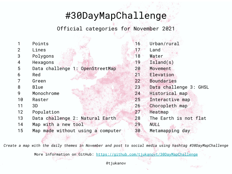
“30 Day Map Challenge” happened over November. Remembering this from last year, I knew we were in for a bombardment of cartographic creations on the #30DayMapChallenge hashtag. Combining this with a search for “OpenStreetMap” mentions I sat back and let the mappy goodness flow into my tweetdeck for the whole month.

30 Day Map Challenge daily challenges

Here’s some I particularly liked:

See full entry

During the State of the Map Africa 2021 conference especially on theme of leaving no one behind and underrepresented communities as well as emerging from a global pandemic, as a women I understood the importance of inclusion and equity, I got to know the role of Representing a local community in the geospatial data collection on the OSM and discovered that is no longer impossible but it easy and applicable on any achievable scare any local growing Local community can afford .

Therefore, with all the ideas speakers emphasized at the conference we fully explored the topic of Beyond mapping and Reusing Open Street Map data/FOSS4G where we were able to learn how community can make use of available Geodata for personal and institutional development.

Also taking about the free software we were able to understand further the four major advantages that come with the free software like the run, improve, share , and Study. Generally, on our side, the experience was good especially the marathon, keynotes from different speakers, panel discussions, and lightning talks were really exciting . During this conference, I came to learn about the Open Mapping Hub ESA and the roles the hub has played to expand the Mapping communities in the region through the funding of various projects like the Open Cities Project in collaboration with other international institution.

In fact what I can say is, yes we still have a lot to learn about challenges and opportunities available , as well as tools to use . but the biggest interest everyone took as a take away considering my local community members who managed to attend , is that , it is no longer impossible for women , mothers and underrepresented community youths in general .

Location: Kiyovu, Akarere ka Nyarugenge, Umujyi wa Kigali, Rwanda

My name is Mr. Mbunzama Narcisse an Open street Map enthusiast based in the democratic republic of Congo. I had the chance to participate in the virtual Open Street Map Africa 2021 conference.

This conference was an opportunity for me first to learn about different projects on the Open Street Map implemented across the Africa continent, I also had the chance to acquire new knowledge on Open street Mapping tools and to meet and interact with other mappers from across the continent.

The sessions, the workshops were a unique opportunity for me to better understand certain concepts and to have a great insight on open street map use in Africa, going from different fields such as the Open street Map uses in School, women active in geospatial fields, the use of JOSM to map, Open street Map in health areas and other humanitarian and environmental fields where Open street Map use hugely use.

Overall the conference went well, and it was a success. However for a virtual conference and taking into account the time of the conference, it seemed very long taking into account other realities that we sometimes have in Africa such as regular power cuts, connection problems to the Internet. Internet. It would be better for future virtual conferences to see how to reduce the time of online meetings (For example from 12:00 to 18:00 will be very easily followed than a meeting from 10:00 to 20:00) and also to directly record the sessions and upload these videos to allow participants to review it even after the conference.

Location: Madimba, Kongo Central, Democratic Republic of the Congo
Posted by Benjaminokeyoh1 on 6 December 2021 in English.

Based on the State of the Map conference 2021 theme of leaving no one behind and emerging from a global pandemic, as a student I understood the important role universities play in the geospatial data collection on the OSM. Therefore, with much emphasis from speakers at the conference we fully explored the topic of Beyond mapping and Reusing Open StreetMap data/FOSS4G where we were able to learn how students and the community can make use of available Geodata for personal and institutional development. Also taking about the free software we were able to explore further the four major advantages that come with the free software like the RUN, SHARE, IMPROVE, and STUDY. Generally, on my side, the experience was great especially the marathon, keynotes from different speakers, panel discussions, and lightning talks were great. During this conference, I came to learn about the Open Mapping Hub ESA and the roles the hub has played to expand the Mapping communities in the region through the funding of various projects like the Open Cities Project in collaboration with the World Bank.

Location: Busitema University, Busia, Uganda