 OpenStreetMap

We moved from Terneuzen to Etten-Leur as did the focus of my contributions since my previous message. Now I mainly concern myself with mapping walking paths.
Users' Diaries
Recent diary entries

I’m editing OSM with JOSM for many years now. After so many years, the UI of it is still something that kinda throws me off, it feels quite clunky at times, not all icons do make as much sense, and it’s not consistent with other editor tools.
But what kinda grinds my gears, is that after so many years, it still can’t do hardware acceleration.
Yes, I’m an nVidia pleb, but it’s something I feel like I must roll my eyes round every time I use this. Given a fast enough CPU it at least still works, but having more complex graphical things work better in a browser, is kinda saddening.
On one hand I feel kinda entitled to tell people to “fix it”, but then again, I should probably look into it myself, I don’t know. I think it’ll be next to impossible to fix anything in JOSM. Last time I’ve checked, the codebase is a little all over the place. That, and it’s also just too big. But there are a bunch of things that I’d like to have changed, I guess. On the other hand, iD is also quite annoying at times, but fixing tags presets with it, is whole lot more convenient than in JOSM.
Perhaps one day, the Java gods will have mercy and fix JOSM for us…

今天上午,CCTV13新闻频道新闻直播间播出了航空国家安全反间谍内容,主要讲有人使用设备监测中国飞机信息数据,危害了中国国家安全。其中播出了使用OSM作为底图的某航空信息网站,还把视角停留在东南某海峡(并没有打码,这居然公然播出在国内属于问题地图的地图了,应该是没有发现)。 提醒各位身处中国大陆的地图绘制者,特别是个别爱到处画军事区的人,以后不要再标、画军营了(有的居然把兵种和番号都标出来了,你给谁看呢?),反正平民对于这些信息是不需要的,如果哪天被政府发现了,把OSM墙了,这些人都要负责嗷。
Posted by muhammadhendarmoko on 31 October 2021 in Indonesian (Bahasa Indonesia).

Kesultanan Amangkurat
Posted by JesseAKARaccoon on 30 October 2021 in English.

In San Francisco, several roads are marked as having sidewalks, which is normal and good. But I notice some (like Van Ness Avenue here) are marked with foot=yes as well. Even though you clearly shouldn’t be walking around in the actual busy street.
This seems pretty wrong? Being marked as having a sidewalk should be enough for routers. As a bonus, the sidewalk is double-mapped, and Van Ness should be marked sidewalk=separate, I think.
I see a lot of this in SF, which is why I’ve been hesitant to fix it. But I can fix this, right?

Maybe someone is trying to steal the name here by deleting and readding things at the same time. They have similar profile descriptions almost can be identified as fake/illogical. They share similar behaviors and may even be able to write a diary.
However, they have received blocks in the history:
osm.org/user/NorthwestPAmapper (we caught this account churning in Maryland by deleting a whole shopping mall with surrounding area and failed to readd back after 3 days).
osm.org/user/theurbanexploringman
osm.org/user/buildingroadfixer12
I assume that some laymen residing in that area are willing to join and improve the project, but the repeated similar behaviors prompt me to believe that it is abnormal.
If anyone above thinks that you are being offended, please reply and tell us why you keep churning. Seriously speaking, I wish to know the benefits as well!
Posted by Nicxon Piaso on 29 October 2021 in English.

I have almost doen most edits of Buildings around Gerehu in NCD..A little more to do at Stage 6..After that all should be good around that Suburb area in NCD.

For months now I’ve been wanting to properly do the Zoning and Land use of Madison county, but I’ve finally got around to doing it. I plan on beginning with farmlands around the northern half of the county in order to fill up a lot of the empty space. I do hope that once I begin to add in residential, commercial, industrial, and retail areas into the metro east, More people would begin to add things in the region, seeing I want to get the region to be more active by adding things that people would not really know how to do first thing.
Posted by uesp madrid toledo mentrida e1a541 on 27 October 2021 in Spanish (Español).

h
Posted by jinalfoflia on 27 October 2021 in English.

For folks who would want to add some road names in Klang Valley, we have an interesting maproulette challenge for you! These are for mappers who are a little experienced. Here’s where you can get started: https://maproulette.org/browse/challenges/23131

Put your mapping hats on and let’s do some mapping!
We would love to hear your suggestions and feedback on these tasks so that we could better next time.
PS: Can’t wait to see who is going to be on top in this challenge (psst.. We have some goodies for you) 😉
Happy Mapping!

A few weeks ago TrekClimbing asked on talk-gb about tagging various types of vegetation. He has documented some of the more problematic ones on the wiki.
The usage of natural=heath in the UK has not been particularly consistent, and his examples confirmed this. The situation is not helped because large swathes of natural=heath were added by a single mapper. Although doubts were expressed at the time, no-one was confident enough to say that such mapping was wrong.
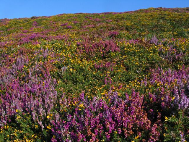 Colourful late summer heath at South Stack
I have been aware that in upland areas of Great Britain natural=heath includes things I would describe differently. Notably these include : upland acid grassland used for rough grazing (mainly of sheep) and blanket bog.
It occurred to me that by comparing OSM data with another source would quantify this impression. Fortunately, a suitable source exists for Wales: Phase 1 habitat data.
Posted by Mordechai23 on 26 October 2021 in English.
Last updated on 4 July 2022.

This is a collection of gifs illustrating the process of me and other mappers redrawing landuse, buildings, paths and other objects in my home city - Wrocław
Most gifs represent the state of OSMcarto immidiatelly before and after the main bulk of my edits in the area and thus may not include later changes made by me or other contributors
Current goal is to revise the core city centre of Wrocław and then possibly other densely populated areas. I focus on realigning and correcting the geometry of existing buildings and adding missing footways, driveways, green areas and landuse, while ignoring the City’s street grid and POIs
Those edits are mainly based on areal photos from 2018 and 2021, complimented by photos from fotopolska.eu and of course my own observations made while strolling around ;)
Why?
- First of all, before my edits there was next to none landuse in the city centre and not much more in the suburbs.
- Secondly, most of buildings here are remnants of an old, poorly executed import and are often misaligned, crossing each other or were simply demolished since 2011. Some buildings were broken down into small parts without using building:part tagging
- But most importantly, we’re observing a big influx of new users contributing via StreetComplete and other similar tools. Those users often edit the old, problematic buildings, with huge issues with geometry, potentially causing problems later. By replacing those, I try to provide more meaningful challanges for those users to complete ;)
Progress (finished 04.07.2022): 149/149 areas, 100% done 🎆

When working with OSM it’s generally fair to assume that textual data, like tag values, are encoded in UTF-8. Without this assumption, multilingual mapmaking would be almost impossible - custom fonts or browser settings would need to be specified for every language when displaying geocoding results, routing directions or map labels.
As part of the newly resurrected Engineering Working Group, I’m investigating ways to improve OSM’s software ecosystem. One of the top tasks for the EWG is localization, and standardized text encoding is a prerequisite for this, but OSM does not enforce any particular encoding as policy.
Where is the non-Unicode data?
The most obvious instance of non-Unicode in OSM is the Zawgyi encoding for Burmese text. For background on Zawgyi, see this post on the civil war between fonts in Myanmar.
The default Mapnik-based rendering on OpenStreetMap.org, openstreetmap-carto, uses Unicode fonts. Zawgyi-encoded tags appear obviously garbled on the map, with the combining mark ◌ visible:
Posted by MKnight on 25 October 2021 in German (Deutsch).
Last updated on 30 October 2021.
… da fallen einem paar Sachen unangenehm, nervig oder interessant auf, die will ich mal hier festhalten.
Vorweg. Ich hab die letzten Wochen meine Zeit vertrödelt um Thüringer Autobahnen mit Leitplanken zu beglücken. Mehrwert nahe -Null, aber da in der letzten Zeit die Relevanzdiskussionen in OSM immer ekliger werden, dachte ich mir: mach mal was hart OTG, wo Dir keiner vorn Karren scheisst. (Siehe auch) Bis auf die A 71 ist das nun flächendeckend, bei der geh ich’s nun aber bisschen langsamer an.
Ärmel hochgekrempelt und die A 4(overpass) als Beispiel gehts los.
Gibt 2 Arten von Leitplanken, barrier=guard_rail und barrier=jersey_barrier. Ersteres sind die Blechdinger, letzteres die Betonklumpen. (Gibt noch ne dritte Art, das wäre barrier=kerb in Tunneln, aber das mach ich ma irnkwann, wenn mir nix anderes doofes einfällt. Vielleicht gibt’s dann hier im Kino was neues dazu.) Die Betondinger sind gern in der Nähe von Brücken anzutreffen, die Aludinger haben auf Brücken gern die Eigenschaft two_sided=yes.
Hach Brücken, hat man mal paar 100km Leitplanken gemappt fällt auf oder ein: Brücken und layer. Also den ganzen Kladderadatsch noch mal “abgelaufen” und layer zugefügt. Im selben Atemzug ca. 50% fehlende man_made=bridge ergänzt incl. Schere im Kopf, was jetzt bridge und/oder tunnel ist. Die ganzen Relevanz- oder echten Diskussionen zum Thema ignoriert und nach gusto “korrigiert”. Meine Interpretation: wenn am Luftbild erkennbar ist, dass die Strasse “überirdisch” verläuft, dann ist es eine Brücke. Ich möchte da hier nicht drüber diskutieren, das Thema ist ein anderes. Und semi-unlösbare Spezielfälle gibts auch.
Wo war ich?
Jedes Mal, wenn ich die Autobahnen ablaufe, finde ich neue Sachen die fehlen.
Was jetzt noch fehlt sind:

Objective
For a while now I’ve been contributing in smallish countryside cities. While not small through their surface area nor their population count, they have a low proportion of active OpenStreetMap contributors and their urban development share a common pattern that is “downtown commercial arteries” leading me to classify them as “countryside cities” rather than “modern evolved and distributed cities”. Those commercial arteries are defined by a street network of mixed uses buildings with shops at ground level and housing at higher levels ; Walking down one of these street, one could model the facade as a succession of doors allowing access to either a shop or housings and that’s exactly what I am looking a software for.
Criterias
I have searched and tested multiple solutions in my journey but haven’t quite found the ideal one so far. The criterias I am looking for are as follows:
- Lightweight: I’m one of those still using old hardware limited both in memory and performance ;
- Offline map: I’m a cheap guy, allow me to cache the mapping area through WiFi before leaving home ;
- “Notes” creation rather than Waypoints: Most of the apps allows you to create “waypoints” on a GPS trace, while those have their use I definitely can’t use those as GPS function is rather battery intensive and high-rise buildings, or simply clouds, highly affects signal quality. Given a map (see aforementioned point) I would rather be allowed to pinpoint a location and add my own tags to it. Those data could then be exported to a computer to be processed through comparison with OpenStreetMap data.
While not dealbreaking, the app use could be extended through an uncluttered UI and workflow, a customizable presets to one-tap buttons function could make themed mapping parties a breeze, and pictures/voice records.
Tested solutions
Below are some solutions I tested with no success so far.
“Utility” solutions

I’m having a ton of fun trying to fix up my local community and close surrounding areas and other little interesting things. Here’s hoping that what I am doing will have an impact on someone’s journey thru town or even one of my fellow locals! I’m having a blast as a beginner, why didn’t I do this sooner?!
Posted by raphaelmirc on 23 October 2021 in Brazilian Portuguese (Português do Brasil).

Hoje venho compartilhar com vocês as novas pastas criada pelo IBGE ( Instituto Brasileiro de Geografia e estatisticas ) orgão que disponibiliza os dados para que possamos mapear e atualizar os dados existente no Openstreetmap para o Brasil.
Só tinhamos dados de 2010 da area Urbana e 2017 da area Rural, hoje temos dados de 2019 e 2020.
Esse link tem os endereços para baixar os arquivos zipados de 2010, 2019 e 2020. https://geoftp.ibge.gov.br/recortes_para_fins_estatisticos/malha_de_setores_censitarios/censo_2010/
No Gith temos esse repositorio com os endereços para baixar os arquivos e ainda disponibilizados os arquivos para baixar no modo torrent, facilitando ainda mais o donwload dos arquivos. https://github.com/vgeorge/cnefe
Baixar torrent dos arquivos do IBGE.
ARQUIVO PDF CNEFE 2010 https://raw.githubusercontent.com/vgeorge/cnefe/master/torrent/cnefe-2010.torrent
Faces de Logradouros (2010) https://raw.githubusercontent.com/vgeorge/cnefe/master/torrent/cnefe-2010-logradouros-2010.torrent
Faces de Logradouros (2019) https://raw.githubusercontent.com/vgeorge/cnefe/master/torrent/cnefe-2010-logradouros-2019.torrent
Faces de Logradouros (2020) https://raw.githubusercontent.com/vgeorge/cnefe/master/torrent/cnefe-2010-logradouros-2020.torrent
FTP IBGE - 2010. https://geoftp.ibge.gov.br/recortes_para_fins_estatisticos/malha_de_setores_censitarios/censo_2010/base_de_faces_de_logradouros_versao_2010/
FTP IBGE - 2019. https://geoftp.ibge.gov.br/recortes_para_fins_estatisticos/malha_de_setores_censitarios/censo_2010/base_de_faces_de_logradouros_versao_2019/
Today I come to share with you the new folders created by the IBGE (Brazilian Institute of Geography and Statistics) which makes the data available so that we can map and update the existing data on Openstreetmap for Brazil.
capmas


It took us 2 years, and 22 days but it’s now “complete.” 😉
Well, at least, all the published tasks has been completely reviewed, resulting in 39,129 mapped schools out of the 39,966 tasks. An additional 837 tasks has also been reviewed but was deemed unverifiable, or needed further information.
The school dataset was informally released to the OSM-PH community in 2013 but languished in the pipeline because of a murky data license until official permission to use it with OpenStreetMap was obtained in 2016. Even with that out of the way, it still needed tons of work before it was ready for use.
In October 2019, the cleaned-up dataset was made into a MapRoulette challenge, as a practical mapping exercise for MapAmore’s mentoring program for NSTP volunteer students from the Polytechnic University of the Philippines’ campus in San Juan City.
Currently upgrading around Mid-Selwyn area.
Including: - Residential areas - Buildings - Roads - Intersections - General tidying up