Users' Diaries

Recent diary entries

Posted by Gustavo22Soares on 22 October 2021 in English.

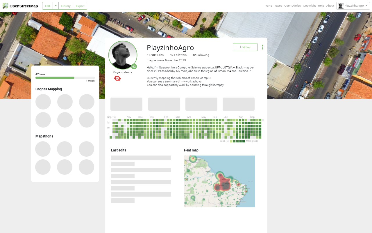
I would like to start by explaining that this is an exercise in imagination on how we could improve the UX/UI in the OSM profile, this means that some changes were based on my experience and there are still some things missing that I have not explored, like the Diaries, settings and Messages, I would love to get feedbacks from you!!!
User.png

More social and personal

See full entry

Location: -5.117, -42.830

Eu gostaria de inicio explicar que se trata de um exercício de imaginação de como poderíamos melhorar a UX/UI no perfil do OSM, isso quer dizer que algumas mudanças foram com base na minha experiencia e ainda faltam algumas coisas que não explorei, como os Diários, configurações e Mensagens, adoraria receber o feedbacks de vocês!!

User Profile

Mais social e pessoal

See full entry

Location: Parque Aliança, Timon, Maranhão, Região Nordeste, Brasil
Posted by imagico on 22 October 2021 in English.

When the current OSMF board some time ago spoke (during a board meeting) of the upcoming OSMF board election season as silly season i interpreted that as a indication of highly problematic collective and undifferentiated disrespect and loathing for the constituency (what we in German call Wählerbeschimpfung). I failed to consider that this would be prophetic regarding board members’ own actions during this time.

Compare:

osm.wiki/Foundation/AGM21/Election_to_Board#List

and last paragraph of:

osm.org/user/mikelmaron/diary/391498

(in the not unlikely case of retroactive censorship here is the permanent record).

OTOH of course the saying is: In a democracy people (collectively) always get the government they deserve

Logo banner

The FOSS4G SotM Oceania Perth Hub conference program has just been announced, with a few things about OSM (including a small talk by me, but I’m not promising anything amazing!). The bit I’m most excited about is an OSM workshop all day on Saturday the 13th: everyone should come along, with laptops, cameras, and GPSs (or just a phone), and learn to edit the map!

Location: Perth, Western Australia, 6000, Australia
Posted by martien-176 on 20 October 2021 in English.

As a validator and #Slack validation channel visitor I am regularly confronted with complaints from fellow validators about the sometimes bad quality of the mappings of beginner mappers. This refers especially to buildings and to a lesser extent highways. Adding to the frustration is that instructive comments after invalidation of tasks hardly seem to be read by these same beginner mappers. The result is often that a task is invalidated several times for much the same reason(s).

Therefore validators can get the feeling that they are “fighting against all odds”. This can work as a demotivating factor. Possibly that even some validators quit validating.

Several solutions have been tried and applied. Ranging from getting the notifications more in sight within the Tasking Manager, limiting iD Editor in which features can be mapped to making Project authors creating their project more beginner friendly.

And of course there are the training webinars organized by the Training Working Group. These are good introductions for new mappers to get themselves onboard. However, they are imo mainly visited by the more motivated mappers. While the bulk of the problem is with the large group of casual mappers, of whom some only map incidentally (e.g. during a one-time mapathon event).

But why not attack the issue right from the start? Why not educate new mappers before they make their first edit?

There are several possibilities.

Sandpit

A virtual space where new mappers can exercise their skills and get some form of basic automatic feedback. Mimicking how mapping a real world task would look like. The mappings will not be saved in the OSM database, so mappers can make mistakes without consequences. Feedback is given automatically, through popups or messages in the margins. The ID Editor WalkThrough could serve as an example.

Quiz

See full entry

Posted by BryDee on 20 October 2021 in English. Last updated on 22 October 2021.

Early in 2021, we at the Open Mapping Hub - Asia Pacific (OMH-AP) first began discussions to collaborate with the World Organization of the Scout Movement (WOSM), through the World Scout Bureau/Asia Pacific Region (WSB/APR). Both organizations understood the atypical environment and the challenges we are all working around with amidst the pandemic. On the other hand, we also saw exciting and innovative opportunities to bring together technology and open-source mapping through OpenStreetMap (OSM), and the energy of the young people that WOSM is working with in the region.

We are delighted to share that the OMH-AP and WOSM, through WSB/APR have signed a Letter of Intent on October 17, 2021, signifying a three-year agreement between the two organizations. It captures our mutual commitment of creating and using up-to-date, high quality map data in OSM for humanitarian response and decision-making in the region. Through this partnership, we aim to mobilize the network of Scouts from their 30 national Scout organizations within the Asia-Pacific Region to map from the grassroots level. Both OMH-AP and WOSM recognize that to achieve this impact, it is vital to work together as part of a larger movement.

See full entry

Location: La Paz, District I, Makati, Southern Manila District, Metro Manila, 1204, Philippines
Posted by DENelson83 on 19 October 2021 in English.

In case you are wondering what I am scheming with my recent changesets, I have started converting individually-named bodies of water on the Atlantic coast of Canada to relations. I started with Cobequid Bay, progressed out the Bay of Fundy to Passamaquoddy Bay and St. Marys Bay, and I have subsequently rounded Cape Sable Island and gotten as far northeast as Liverpool Harbour, progressing towards Halifax. What I am intending to do with this series of edits is to make relations for bodies of water throughout the entire coast of Canada, from the Bay of Fundy all the way to the Beaufort Sea. I have already done this for the Pacific coast, and I figured I might continue this through the rest of the coastal areas of the country. And this little pet project is going to take quite a bit of time to complete, given just how vast Canada is and how much coastline she has, the most out of any country in the world.

The Grind

After 13 days I today finished my review of all streets in Mülheim an der Ruhr, added the street name origin and roadkey ger: “Straßenschlüssel” where possible.

I have been casually adding street name origins for some time, an interesting topic if you are into history I think. At some point I set out to review all streets from A-Z, and while doing that add the roadkey too, as described in osm.wiki/DE:Key:de:strassenschluessel

Orientation and inspiration came from osm.wiki/Düsseldorf/Projekte/Straßennamen

Gladly Mülheim provides a list that had both, a name origin hint and a reference from that I could get the roadkey, on their website: https://geo.muelheim-ruhr.de/node/14033

Along the way I made some minor additions, on about 4 occasions OSM didn’t have the street name or was missing renames for instance.

After having worked through the list I verified the presence of “Straßenschlüssel” by Overpass:

[out:csv("name",
         "de:strassenschluessel_exists",
         "de:strassenschluessel",
         "local:strassenschluessel",
         "wikidata",
         "wikipedia",
         "wikimedia_commons",
         "name:etymology:start_date",
         "name:etymology:wikidata",
         "name:etymology:wikidata:missing",
         "name:etymology:wikidata:note",
         "name:etymology:wikipedia",
         "name:etymology:description",
         "name:etymology:note";
         yes;
         "|"
        )]
[timeout:250];

{{geocodeArea:Mülheim an der Ruhr}}->.searchArea;

(  
  wr[highway]
    [highway != platform] 
    [name]
    [!"de:strassenschluessel"]
    ["de:strassenschluessel_exists" != "no"]
    (area.searchArea);
); 

out geom;

See full entry

Location: Altstadt I, Eppinghofen, Rechtsruhr-Süd, Mülheim an der Ruhr, North Rhine-Westphalia, 45468, Germany
Posted by bryceco on 16 October 2021 in English.

Go Map!! is now a desktop app for Mac, in the App Store: https://apps.apple.com/us/app/go-map/id592990211

Did anybody ask for a desktop version? In fact a few people did, but the primary reason to release it is “because we can.” Many people edit using iPad, and many of those people use mouse/keyboard, so adding support for those input methods got the app 80% of the way to full desktop support. Enjoy!

screenshot

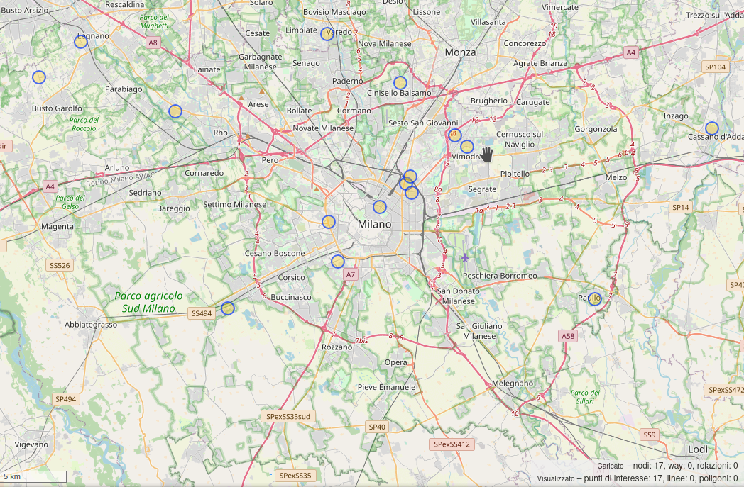
If you have a beautiful bunny sadly you can’t take them to a regular vet. You need “exotic experts”. This is true at least in Italy.

That’s why I tried to expand an OpenStreetMap RFC about veterinarians, to cover this case.

The result? See with your eyes:

OpenStreetMap veterinarians for rabbits

https://overpass-turbo.eu/s/1c7F

It’s absolutely amazing how somebody can expand OpenStreetMap so quickly to add useful metadata and being able to query them in realtime.

https://overpass-turbo.eu/s/1c7F

Happy bunny!🐇

Location: Municipio 1, Milan, Rodano, Milan, Lombardy, Italy