 OpenStreetMap

이게뭐야
Users' Diaries
Recent diary entries
Posted by q_un_go on 26 August 2021 in German (Deutsch).

Was lesen meine Augen in JOSM?
Für Anfänger*Innen.
Geht es denen noch gut?
Da bekommt man ja Augenkrebs von derartigen Ausdrücken.
Nett wäre es, wenn man zwischen gegendert und ungegendert bei Deutsch als Sprache wählen könnte. Kann man aber nicht. Statt dessen wird es einem aufgezwungen.
Ich habe die Spracheinstellung daraufhin in JOSM auf Englisch umgestellt.
Posted by Hans Thompson on 25 August 2021 in English.
Good tidings!
My effort to add the natural features to Nancy Lake is finished. osm.org/#map=12/61.6291/-150.0966
What was the point of adding these natural features to a wilderness?
Well, besides being one of my favorite spots in Alaska, mostly I’d say it was just another project like mapping Anchorage where I could incrementally improve and feel some accomplishment at the end. At the end of the day, I hope these edits provided value but it’s my goal to be driven by the small neurochemical treat-reward cycle of editing OSM instead of doing nothing which would be less valuable than something.
Posted by hanchao on 25 August 2021 in Chinese (China) (中文(中国大陆)).
Last updated on 26 October 2022.

!!!

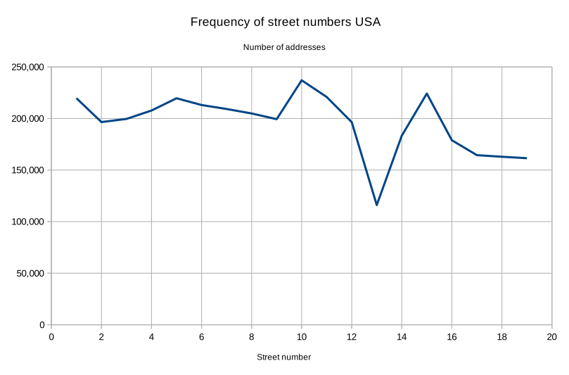
Reading DeBigC’s diary entry on Triskaidekaphobia in Dublin reminded me that I had also looked at the same thing in the USA. The US Department of Transportation (USDOT) has a National Address Database containing about 60.5 million addresses from which we can plot the frequency of street numbers in the range of 1 to 19:
Posted by Vishāl Bāgadē on 25 August 2021 in English.
Last updated on 26 August 2021.

Aurangabad, Mumbai, Pune, Nagpur, Ahmednagar, Nashik, Dhule, Nandurbar, Shirur, Akole, Bhandardara, Sangamner, Shrirampur, Nevase, Bodhegaon, Shevgaon, Balamtakli, Beed, Ambajogai, Latur, Ghargaon, Badgavhan, Chaklamba, Mungi, Chapadgaon, Nilanga, Udgir, Chikhali, Nanded, Makni, Dhanora, Tulajapur, Chakan, Phopade, Khori, Bhopal, Bengaluru, Hyderabad, Delhi, Kolkata, Varanasi, Ellora, Ajanta, Devgad, Satane, Chakur, Chakan, Satara, Loni, Gangapur, Vaijapur, Kasoda, Ambelohol, Bhalgaon, Chitegaon, Dhorkin, Beedkin, Ichalkaranji, Paithan
Posted by AngocA on 25 August 2021 in Spanish (Español).

En Colombia, los ríos tenían diferentes palabras para la palabra Río que hace parte del nombre. Sin embargo, hacer esta modificación de cada way no era viable, por lo que lo hice de una forma masiva. Aquí muestro los pasos para replicarlo:
- Buscar el nombre de departamento o región a analizar, para no hacerlo masivo sino por partes.
https://wiki.openstreetmap.org/wiki/ES:Colombia/Divisi%C3%B3n_Pol%C3%ADtica#Departamentos
- Correr query en Overpass Turbo por departamento.
 [out:xml]/*fixed by auto repair*//*fixed by auto repair*/[timeout:25];
  area[name="Colombia"][admin_level=2][boundary=administrative]->.searchColombia;
  area[name="Amazonas"][admin_level=4][boundary=administrative]->.searchDpto;
  (
   way["waterway"="river"]
   ["name"~"^(Rio|rio) "]
   (area.searchDpto)(area.searchColombia);
  ); (._;>;);
out meta;/*fixed by auto repair*/
- Revisar que los ríos quedan dentro de Colombia, ya que si son fronterizos no queremos hacer cambios fuera de la jurisdicción. Para esto se ven los resultados de overpass turbo en el mapa.
- Si quedan fuera de Colombia, editar los ways individualmente para que solo tome lo de Colombia partiéndolos justo en la frontera.
- Exportar los resultados del query de Overpass Turbo a JOSM.
- Una vez en JOSM, seleccionar todo, Ctrl A.
- Abrir el filtro para solo seleccionar los ways Ctrl F.
- Indicar en la ventana:
selected type:way
- Adicionar una etiqueta para que modifique todos los ways. En mi caso puse esta:
andres=gomez
- Guardar los datos como rios.osm
- Borrar la capa modificada.
- Desde una terminal que tenga sed (Linux, Max, cygwin, mobaxterm en Windows) hacer el cambio masivo por medio del comando Sed.
sed "s/tag k='name' v='Rio /tag k='name' v='Río /g" rios.osm | sed "s/tag k='name' v='rio /tag k='name' v='Río /g" | sed "s/tag k='name' v='río /tag k='name' v='Río /g" > riosmodif.osm
Posted by bkil on 24 August 2021 in Hungarian (Magyar).
Last updated on 25 August 2021.

-
A közvetítés a megszokottól eltérő helyen lesz, további információk a Wiki oldalon lesznek olvashatók:

doma
Introduction
I started google summer of code with the aim of creating a library that can be easily added to Vespucci and provide it with element comparison features, and provide some other feature requests in Vespucci. I was able to create and deploy the Element History Dialog, which can be found here, where you can find the implementation details for the library.
Work Done
The major work done during the coding period includes the following -
- Creating the parser for OSM elements
- Creating the parser for Changesets
- Creating the UI to list all versions for a selected OSM element
- Creating the UI for comparison between different OSM elements
- Logic for comparison between tags of different versions of a element
- Logic for comparison between data for 2 versions of a node
- Logic for comparison between data for 2 versions of a way
- Logic for comparison between data for 2 versions of a relation
- Handling edge cases like deleted elements and versions
- publishing the library and creating the sample application
A more detailed usage guide can be found on the github readme
Future Scope
Some additions to the project that I plan are -
- Creating more test cases - currently there are a few unit tests that test the basic functionality of the app, I will add more unit tests to cover most logical operations and few UI tests to test the basic flow of the library
- Adding the library to vespucci
- Creating Pull Requests on Vespucci for other features mentioned in my gsoc application.
Finally, I would like to say that my experience with the OSM community has been great, and I would love to contribute more to the great projects that are hosted by OSM

pos
I’ve been working on collecting datasets for various chains across the UK, and the globe. Yesterday I changed the repo to open, so say hello to KAFF Places. It’s mainly got retail chains, but it also some hotel chains, pharmacies and the like. You can see the list here.
This data is first party from their respective websites, interestingly enough there are a lot more quality issues that come with that than I expected. I have reached out to some of them to point out issues, and I’d love to work with all of them to improve their data.
I’m waving any database rights I may have, but because this is first party data each provider holds copyright and/or database rights. I currently do have some rules on which sites I collect data from, the most important rule is that they are publishing the data in Linked Data or Microdata. I personally believe once somebody explicitly publishes data in a machine readable format they want the data to be used. However the law may disagree. This shouldn’t be used as a source for OSM.
Some of this data is already being used by Robert Whittaker in Chain Reaction to help monitor the quality of OSM coverage. I’d also like to see this data being used as an overlay on top of OSM data to increase coverage in under mapped areas, in projects like OsmAnd and Daylight Map Distribution.

I map a lot of buildings in northern Dublin City. I also interrogate housenumber interpolations, view mapillary for little peeks of the housenumbers that aren’t blurred, and do my own StreetComplete captures to add as many address details as possible. Lately I have noticed something, born from a concern that I was doing something wrong, or making a mistake.
In a few housing developments around Dublin housenumber=13 doesn’t exist. I have heard of such indulgences before, for example some airlines dropping row 13 from seating plans, or the Irish car registration authority famously dropping its numeric system in 2013 to avoid the unluckiest of car numbers.
So out of curiousity I hit OverPass Turbo and launched a series of queries like this into the existing housenumbers. I couldn’t do loads of these so I thought that maybe 19 would be a sufficient sample (42,000 building objects) to make comparisons and establish patterns.


Today we’ve started rolling out the 1st beta release of 16.0. If you intend to install this, or at a later date the release version, please read the release notes http://vespucci.io/help/en/16.0.0%20Release%20notes/ before installing.
Due to the preparation for targeting Android 11 there have been some changes in where files are stored that you need to know about.

漢字的版本
最近毋知是按怎,近期的 zh-CN 日記出現誠濟篇指控 OpenStreetMap 無遵守中國的法律,竟然共台灣標示是獨立的國家。
臺灣人看著這款指控真無爽快,不而過猶是有精神來回應,是講 OpenStreetMap 的政策、運作方式佮精神,特別是爭議領土欲按怎處理的方式。
Pe̍h-ōe-jī ê pán-pún
Chòe-kūn m̄-chai sī án-chóaⁿ, kūn-kî ê zh-CN ê ji̍t-kì chhut-hiān chiâⁿ-chōe phiⁿ chí-khòng OpenStreetMap bô chun-siú Tiong-kok ê hoat-lu̍t, kèng-jiân kā Tâi-oân piau-sī sī to̍k-li̍p ê kok-ka.
Tâi-oân-lâng khòaⁿ-tio̍h chit-khoán ê chí-khòng chin-bô sóng-khoài, put-lî-kò iáu-sī ū-cheng-sîn lâi hê-èng, sī-kóng OpenStreetMap ê chèng-chhek, ūn-chok hong-sek kah cheng-sîn, tek-pia̍t sī cheng-gī léng-thó͘ boeh án-chóaⁿ chhú-lí ê hong-sek.
Tâi-lô ê pán-pún
Tsuè-kūn m̄-tsai sī án-tsuánn, kûn-ki ê zh-CN ê ji̍t-kì tshut-hiān tsiânn-tsuē phinn tsí-khòng OpenStreetMap bô tsun-siú Tiong-kok ê huat-lu̍t, kìng-jiân kā Tâi-uân piáu-sī sī to̍k-li̍p ê kok-ka.
Tâi-uân-lâng khuànn-tio̍h tsit-khuán ê tsí-khòng tsin-bô sóng-khuài, put-jî-kò iáu-sī ū tsing-sîn lâi hê-ìng, sī-kóng OpenStreetMap ê tsìng-tshik, ūn-tsok hong-sik kah tsing-sîn, ti̍k-pia̍t sī tsing-gī líng-thóo bueh án-tsuánn tshú-lí ê hong-sik.

Introduction
As we are reaching the end of the Google Summer of Code 2021, I would like to share with you the work done on my project “Nominatim QA Analyser”.
Previous diary entries
Project summary
Nominatim is the OSM’s main geocoding software used to process geocoding requests on OpenStreetMap data. The software uses its own database schema which differs from the one used by the main OSM database. As a result, Nominatim processes OSM data in a way that allows to discover a lot of inconsistencies. The idea of the project was to build a Quality Assurance Tool which analyzes the Nominatim database and extracts errors from the OSM data based on a set of rules.
These extracted errors are then made available to everyone through a visual map, so that OSM mappers can correct them easily.
Running example
If you are curious about the result of the project, you can check a running instance here: https://gsoc2021-qa.nominatim.org/front/. It has up to date data which are generated by the backend analyser directly on the production server of Nominatim.
The web application will be set up on the official nominatim.org website later this month or early September. I will update the previously provided link in this diary entry when it will be done.
What has been done
The project is divided into two parts, the first one is the main Data Analyser tool which runs on the Nominatim’s server and the second one is the web application used to visualize the data through a map.
Data Analyser
The github repository of the Data Analyser can be found here: osm-search/Nominatim-Data-Analyser. The whole commits in this repository are from my work. You are free to contribute and help to make the tool better.
The development of this analyser includes:

lorem ipsum

AIch habe einen Kontakt in das Helferzentrum in Walporzheim und die brauchen eine Karte mit den Gebäuden und Hausnummern.
Ich habe gesehen, das in weiten Bereichen des Überschwemmungsgebiet diese fehlen.
Vielleicht fühlen sich einige aus der Umgebung angesprochen und können unterstützen.
Mittelfristig könnten die Hausnummern auch noch für die anderen betroffenen Orte im Ahrtal von Interesse werden.
Ich kümmere mich weiter um die Karten bis ich ab 3.9.2021 terminlich verhindert bin.
Bei der Gelegenheit können die wenigen notes gleich noch behoben werden.
Posted by Unkn0wnKevin on 21 August 2021 in English.

I’ve created a small wiki user-page for my favorite places on OSM at User:Unkn0wnKevin/Favorite_Places.
Feel free to copy the source code to your own user page and drop me a message with a link, so I can check out your favorite places!
Posted by Valerio_Bozzolan on 21 August 2021 in English.
Last updated on 12 April 2026.

After 7 days of contributions in StreetComplete in Helsinki you can become user 26th in the whole Finland.