 OpenStreetMap

1.Каждый Человек рисует как умеет 2. Каждый Человек достоин уважения на то , что он изобразил на Карте 3. Нельзя объять необъятное -невозможно всё отобразить на Карте
Users' Diaries
Recent diary entries

A number of areas in the UK (and the world) have painted crossings in LGBT+ pride rainbow colours to support LGBT+ rights.
In the UK at least, these are often referred to as ‘rainbow crossings’. They don’t always look the same, with some using different colours/pride flags.
 Image of rainbow crossing by Matt Brown used under Creative Commons CC-BY-2.0 license.
Here’s a recent example from Bristol, a city in the South West of England: https://www.bristol247.com/lgbtq/news-lgbtq/bristol-gets-its-first-rainbow-crossing/ .
Here’s two in a London borough: https://www.richmond.gov.uk/first_rainbow_crossings_unveiled
and another: https://www.bbc.co.uk/news/uk-england-london-51446121
one at Surrey University: https://my.surrey.ac.uk/news/introducing-our-new-rainbow-crossing
And here’s one in New Zealand - https://en.wikipedia.org/wiki/Cuba_Street_rainbow_crossing
Posted by rainerU on 7 July 2021 in German (Deutsch).
Last updated on 8 July 2021.
Wenn ich mit der Kamera am Fahrrad unterwegs bin, um Bildsequenzen für Mapillary aufzunehmen, ist es oft hilfreich zu wissen, für welche Straßenabschnitte schon aktuelle Bilder auf Mapillary vorhanden sind. Ich kann dann die Fahrtstrecke so anpassen, dass ich bevorzugt Straßen und Wege abfahre, für die noch keine aktuellen Aufnahmen existieren. Dafür nutze ich eine Overlay-Karte auf meinem Garmin Etrex 30s, auf der alle Mapillary-Sequenzen als grüne Linie angezeigt werden, die ab einem bestimmten Datum erzeugt wurden. Abgesehen davon, dass dabei die Aufnahmewinkel nicht angezeigt werden, hat sich dieses Overlay in der Praxis gut bewährt. Mit QMapShak kann ich das Overlay auch für die Planung am PC nutzen. Nachfolgend beschreibe ich, wie ich das Overlay erstelle.
Die Karte wird für ein geografisches Rechteck (Bounding Box, BBox) erzeugt, das durch die Koordinaten (in Dezimalgrad) der linken unteren und der rechten oberen Ecke definiert ist. Verwendet werden Kommandozeilen-Tools unter Linux/Bash. Die Karte wird in drei Schritten erstellt:
- Herunterladen der Bildsequenzen von mapillary.com
- Erzeugen einer OSM-XML-Datei
- Erstellen der Garmin-Karte
Herunterladen der Bildsequenzen
Seit der Umstellung auf die API-Version V4 können die Daten der Bildsequenzen als Vektorkacheln im Mapbox Vector Tile Format herunter geladen werden. Die hier verwendeten Coverage Tiles enthalten eine Ebene image mit den einzelnen Bildpunkten und deren Daten und eine Ebene sequence mit den Bildsequenzen als Polygonzüge. Diese Ebene wird im Folgenden verwendet, um die Sequenzen als Linien über einer Grundkarte darzustellen.

 Seale-Hayne is a former university located in Devon, UK. It was one of the first purpose-built agriculture colleges in the country, the foundation stone was laid back in 1914 and the construction finished in 1918 when the site was lent for the army to treat shell shock victims from the first world war and in 1920 it would finally receive it’s first agriculture student. The university functioned until 2005 when it was closed and the site was sold.
Today it functions as a business centre, hosting different business and charities offices, artists studios, a well-being centre with a pool and a café. It still has a active alumina community which maintains a Heritage Room with objects from the university’s time.
Seale-Hayne is a former university located in Devon, UK. It was one of the first purpose-built agriculture colleges in the country, the foundation stone was laid back in 1914 and the construction finished in 1918 when the site was lent for the army to treat shell shock victims from the first world war and in 1920 it would finally receive it’s first agriculture student. The university functioned until 2005 when it was closed and the site was sold.
Today it functions as a business centre, hosting different business and charities offices, artists studios, a well-being centre with a pool and a café. It still has a active alumina community which maintains a Heritage Room with objects from the university’s time.
I spent last months slowly mapping the place, adding buildings, names, paths and a few of the business. With the help of StreetComplete I could add a lot of detailed info such as number of steps, building floors, surfaces, etc.

I’m about to begin working on mapping out every building, Business, and missing information to Wood River and Bethalto.
Currently I’m going to switch between working on Wood River, and Bethalto, mostly focusing my efforts on getting zoning areas and buildings in place. Thus I will follow those by adding the smaller details, like shop names, addresses, and trees.
Posted by amapanda ᚛ᚐᚋᚐᚅᚇᚐ᚜ 🏳️⚧️ on 6 July 2021 in English.

My May 2021 in OSM
Posted by matheusgomesms on 6 July 2021 in English.
Last updated on 7 July 2021.


(original post in Portuguese here)
Introduction
In the last weeks I focused my efforts on adding vaccination facilities in Fortaleza/Brazil. At the moment of writing, there are in Fortaleza exactly 113 vaccination sites, being (if I’m not mistaken) 100 clinics and 13 other places (such as shopping malls and huge infrastructures like a stadium and convention center).
The method I used for this was to use the open data of the Fortaleza City Council (don’t worry, dear warrior of licenses, we have explicit permission for this) for the locations and details of the clinics, along with the other 13 locations that have been manually updated.
Methodology
Preliminary Step
Posted by raphaelmirc on 6 July 2021 in Brazilian Portuguese (Português do Brasil).

I started today to validate one of the 3 tasks created by OSM Brazil members on the HOT Organization website.
MAPEIAMA - GOOD PASTE
Tasks to be Valid; https://tasks.hotosm.org/projects/10977, https://tasks.hotosm.org/projects/10921, https://tasks.hotosm.org/projects/10980
tasks created by OSM Brazil members in the HOT Organization.
Website of the OSM Brazil Organization. https://tasks.hotosm.org/organisations/osm-brasil
I invite all Brazilian Mappers to validate the tasks mentioned above that are created in the organization of HOT.
Website of the OSM Brazil Organization. https://tasks.hotosm.org/organisations/osm-brasil
===================================================
Comecei hoje a validar uma das 3 tarefas criadas pelos membros da OSM Australia no site da HOT Organization.
MAPEIAMA - PASTOS BONS
Tarefas a serem válidas; https://tasks.hotosm.org/projects/10977, https://tasks.hotosm.org/projects/10921, https://tasks.hotosm.org/projects/10980
tarefas criadas por membros da OSM Brazil na Organização HOT.
Site da Organização OSM Brasil. https://tasks.hotosm.org/organisations/osm-brasil
Convido todos os Mapeadores Brasileiros a validar as tarefas mencionadas acima que são criadas na organização do HOT.
Raphaelmirc - Recife/PE. - Brasil.
Membro da UMBRAOSM - União dos Mapeadores Brasileiro do Openstreetmap.
Member of UMBRAOSM - Union of Brazilian Mapmakers of Openstreetmap.
My April 2021 in OSM
- Kept on mapping of course. Usual day to day mapping.
- Saw a new project to map public toilets in Ireland (Pee.ie), and tweeted at them
@pee_ie, to explain OSM (no reply yet) - Attended a meeting with some Irish OSMers & other Irish Open Data activists about possible new Irish Open Data policy
- Reported a bug in Nominatim, where it depending on certain software that it didn’t claim to depend on
-
OSMF Board
- Discussed with the board, and proposed a AOSMFBAAAoAAAA session at State of the Map 2021.
- Trademarks
- OpenSnowMap
- [3] email recv, open ticket, DMed Simon & Packi
- OpenSnowMap
- Take over protection
- emailed all 27 corp members to seek advice, nothing too detailed.
- Local Chapters
- Board chat about Attribution Guidelines
- Renewed the OSMF’s BigBlueButton server with Cloud68
- email an OSMer to follow up about AoA change ideas.
(Sorry for the delay, I’ll try to catch up, which might result in less detail for this month)
Previously:
2020: Jan. Feb. Mar. Apr. May June July Aug. Sept. Oct. Nov. Dec.
Posted by LaMèreveille on 6 July 2021 in French (Français).
Last updated on 11 November 2024.
Mostly active on Wikimedia project. Start to learn how to contribute also on OSM.
Interest:
- surveillance camera
- data center
Posted by matheusgomesms on 6 July 2021 in Brazilian Portuguese (Português do Brasil).
Last updated on 7 July 2021.
Introdução
Nas últimas semanas concentrei meus esforços em adicionar os postos de vacinação em Fortaleza/CE. No momento em que escrevo este texto são exatamente 113 locais de vacinação, sendo (salvo engano) 100 postos de saúde e 13 outros locais (tais como shopping centers e infraestruturas enormes como estádio e centro de convenções).
O método que utilizei para isso foi utilizar os dados abertos da Prefeitura Municipal de Fortaleza (não se preocupe, santo protetor das licenças, que temos permissão expressa para tal) para obter as localizações e detalhes das clínicas, juntamente com os outros 13 locais que foram atualizados de maneira manual.
Metodologia
Etapa Preliminar
Posted by bkil on 6 July 2021 in Hungarian (Magyar).

-
A közvetítés a megszokottól eltérő helyen lesz, további információk a Wiki oldalon lesznek olvashatók:


Things I’ve done recently:
- Renamed a couple of new roads in Congleton - the new “Back Lane” is now Somerford Lane, and what was labelled “Viking Way” is actually Barn Road all the way to the bypass, confirmed by a new road sign at the north end (Viking Way is actually just the short road leading to the Airbags plant)
- Surveyed some of the shops in the town centre to see what has changed in the last year
- Named a couple of localities, namely West Heath, Mossley and Hightown - I’m not entirely clear where they should be placed but they’re on the map at least
- Extended the Mersey Valley Timberland Trail between Runcorn and Warrington - this was partially mapped as two separate relations which I have merged
約1年半前のものまでしか反映されていないらしいが、マップの見た目がようやく更新された。
当時編集をしていた人でこのゲームをもう辞めてしまった人も多いだろう。
あの頃は不便ではあったけど楽しかったな。贅沢な悩みだ。勝手に懐かしさに浸ってしまった。
マップもEXも更新されたので、当初の目的は完全に達したことになる。
とは言うものの、やるべきことは今後も変わらない。
頻度は落ちるだろうが、ポケスト申請とマップ更新は今後も継続していきたい。

This diary post is a follow up on the one I did last week here where I was looking at how much, and for what the Ireland OpenStreetMap community uses the StreetComplete(SC) app.
The StreetComplete creator Tobias replied showing an interesting worldwide trend for SC usage. The trend here shows that there has been an upturn in SC usage worldwide in the last couple of years in terms of the users and edits contributed:
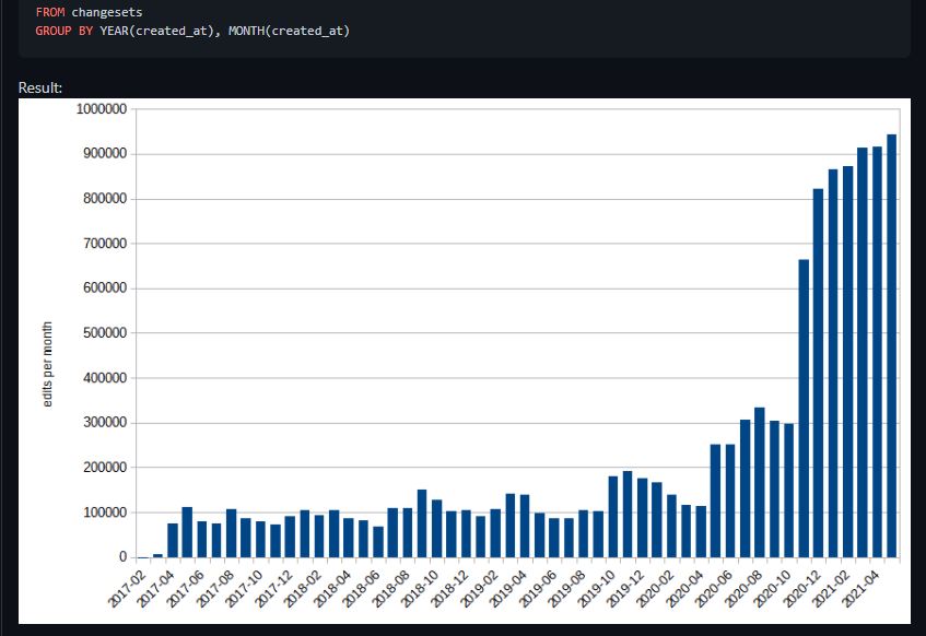
In particular Tobias shows that co-incidental with the Covid-19 months that there was a big upturn in the changesets contributed, starting gradually in May 2020 with a doubling on the previous month, but continuing to rise until the changesets remained at about 4 times the normal level for the forthcoming year. Most users are in the Northern hemisphere, so to see the higher level of changesets sustained through the Northern Hemisphere’s winter months is impressive.
In Ireland the changes, as in the big upturn are also reflected in a little bit of analysis done here.
respect #love#care#thank #universe
I’ve just reached my first OSM milestone by confirming all my contact addresses are in OSM. This took considerably longer than expected. I wanted to add the addresses of all my contacts from around the world to OSM so that those addresses will appear in the next map update for the Magic Earth app.
My first step for this milestone was to cull my contacts list for the first time in 20 years. This step took several hours. My next step was to add the addresses of my contacts to OSM if they did not already exist. This step proved to be a very time consuming and frustrating experience, although there were plenty of learnings too.
The first learning which came quite early on was that when postcodes are introduced to a country, parts of the old address are incorrectly removed by the postal service. In one example, my brother was given a new suburb. Unfortunately, people have a tendency to retain the old address and just add the new post code, rather than using the new address in full.
Needless to say people giving out the wrong addresses like my brother makes life difficult for address search engines. A good address search engine needs to be very clever in accommodating this human behaviour. I found the OSM search engine wasn’t very forgiving, while Google search engine was too forgiving at times by giving me the wrong location.
I decided to edit the addresses of my contacts so that the OSM search engine would find the correct location. I didn’t mind changing the address when it was clear that part of the address was wrong like with my brother.
It was obvious to me that Google tries different permutations of the address to find a result, while OSM expects the address to be perfect. I imagine Google’s first permutation in the UK would be to use the post code and street address as that is all that is needed for a location in the UK. If that permutation failed it would try other permutations with the full address until it got a result.

There are multiple mapping tasks in OpenStreetMap that people still have to do old-style, like we did in 2010. But with current technology and with current funding of OSM research, these can be automated, improving mapping quality over the world.
If you work on OSM-related projects for a company, like in Facebook or Apple, please ask your manager if they can spare your time on projects useful for the community. For example:
-
Imagery alignment! People from the US and Western Europe won’t understand, but in most parts of the world, imagery is offset up to hundreds of meters. Mappers need to shift it to start mapping, otherwise different people would map with different offsets.
We have plugins for automatically tracing roads, buildings and rivers. Why not create a button for JOSM and iD that looks at GPS traces (rasterized or not) and finds the best offset for an imagery layer?
-
okay I had just that one idea and struggle to come up with more
-
please share your ideas in comments


tl; dr:
Firms like Apple, Facebook and Amazon are paying (their own) mappers for OpenStreetMap (OSM) edits. You are an OSM editor making the same type of work the paid editors are. Shouldn’t you be paid for your edits too? Let’s start sending these firms a collective invoice for our work and use the received funds to benefit the OSM ecosystem. There is an easy way to join if you use JOSM, but users of other map editors can participate as well.
The problem
The OSM project is governed by a license that allows its geo data to be freely used by anybody, including the most wealthy global corporations. Regardless, firms like Apple, Facebook or Amazon are paying for improving the OSM data. They do so mainly by hiring mappers, but also by directly sending money to the OSM foundation, albeit with grants that seem rather small in comparison to market capitalization of these firms. These developments - while good for improving the OSM data, raise also some issues. One concerns fairness: if the firms pay their employees/contractors for map edits, shouldn’t they pay to all who make the same kinds of edits? After all, the edits they provide are not special in any respect - volunteer editors have been supplying such data to the OSM database for years. A more subtle issue is, that emergence of paid map editors dramatically changes character of the project, which for most of its existence has been a purely volunteer affair. Increasingly, volunteer mappers can no longer point to “the Map” and say - we, volunteers did this. Others raised this issue as a problem, but no way out of it has been suggested so far.