Users' Diaries

Recent diary entries

Posted by Puxan on 31 May 2021 in Spanish (Español).

Creo que un problema importante para la calidad del mapa son los mapathones.

Durante la pandemia se han multiplicado los mapathones on line. A los que yo he asistido, normalmente, tras una introducción, se dividen los mapeadores en varias salas. Cada sala tiene asignado un representante del equipo organizador para resolver las dudas del grupo

Se podrían implantar dos normas para mejorarlos:

1.- No admitir al mapathon a mapeadores nuevos que no hayan completado al menos un tutorial de los que hay en la red (learnosm.org, el incluido en la ayuda del iD Editor, …). Yo veo que actualmente se admiten mapeadores que ni siquiera se han registrado aun en OSM. Los que no hayan podido completar ese mínimo trabajo previo pueden ser dirigidos a un próximo mapathon

2.- El equipo organizador debe comprometerse a revisar todos los changesets del mapathon en un plazo corto de tiempo (¿7 días?) y mandar un informe de ello a cada mapeador. Si es preciso, se reduce el número de mapeadores al número que pueda revisar el responsable de cada sala.

El equipo organizador debería velar por la categoría de los responsables de cada sala de mapeo

Location: Sant Antoni, Mahón, Menorca, Islas Baleares, 07701, España
Posted by jinalfoflia on 31 May 2021 in English. Last updated on 13 October 2021.

Are you wondering what to map next? Don’t worry we got you covered! We have three interesting tasks as the next maproulette challenges for you all. They are for mappers who are just starting or are experienced. Here are the tasks for you all:

  1. Connectivity checks: https://maproulette.org/browse/challenges/17714
  2. Sharp Angle checks: https://maproulette.org/browse/challenges/17716
  3. Invalid turn restrictions: https://maproulette.org/browse/challenges/17715
  4. Crossing ways: https://maproulette.org/browse/challenges/17943
  5. Wrong one way- double way - https://maproulette.org/browse/challenges/17958
  6. Road Islands - https://maproulette.org/browse/challenges/17950

Put your mapping hats on and let’s do some mapping!

We would love to hear suggestions and feedback from you on these tasks so that we could better ones next time.

PS: Can’t wait to see who is going to be on top in this challenge (psst.. We have some goodies for you) 😉

Happy Mapping!

Primeiro Voluntário no Brasil.

Hoje Pesquisando os Usuários no OpenstreetMap acabei encontrando esse usuário com registro de Primeiro Voluntário no Brasil, a data do seu registro e de 2006 e o Nome de Usuário se chama, Claudomiro e o seu Diário osm.org/user/Claudomiro/diary relata que é o primeiro voluntário no Brasil, Seu Diário também mostra informações de Viagem, encontros com outros Mapeadores e todo o Inicio da Comunidade Brasileira do Openstreetmap que hoje conta com muitos mapeadores que se registra todos os Dias.

See full entry

Location: -8.122, -34.954

About 6 weeks ago, I signed up to openstreetmap.org (OSM) to map my contact’s addresses and my public transport routes. My thinking was that adding these details will mean I will use OSM based apps everyday. When I add new contacts in the future, I will add their addresses to OSM too.

Of course, the first address I added was my home address and then the addresses on my street. I posted my initial impressions of OSM in my diary and people commented about my diary entry. I read their comments and their diary’s. I learnt from their diary’s that addresses can be automatically imported to OSM from government data sources as long as OSM have permission to use those data sources. I didn’t want to be doing work that could be automated, so I checked to see if my government offered open data that listed all the addresses in Australia. I learnt that such data existed and that another OSM mapper was requesting the appropriate government permissions to automatically import this data to OSM. I also learnt that with a powerful computer and AI software that buildings can be mapped too. I felt quite disillusioned and decided to take a break.

I came back with the idea of recording GPS traces of my public transport routes, but then I learnt that the GPS on my Nokia 6.2 has a known issue with accuracy.

Then I decided I would add nodes for local businesses, which is based on local knowledge and will not be automated for many years to come!! Initially, I thought I could map those businesses off the top of my head having passed them for years. As soon as I sat down at my PC to add those businesses I realised I couldn’t remember some businesses.

So, I went down the street, mentally recording the sequence of the businesses. I returned to type in the business names and their addresses. OSM made me really look at my surroundings and there were things I didn’t notice in my neighbourhood. That’s when I got hooked on adding more information about these businesses to OSM.

See full entry

This diary is about load testing. I find load testing useful mainly because of two reasons: 1. it shows multiuser access problems; 2. it shows how good is the implementation.

The idea is to simulate mapathon. A mapathon is an event where multiple mappers map the same (big) area. To manage the work, the area is divided into smaller squares. Then, each mapper asks the server to map or review a square, works some time on the square, and finally asks the server to mark the square as needs mapping, needs review, or is done.

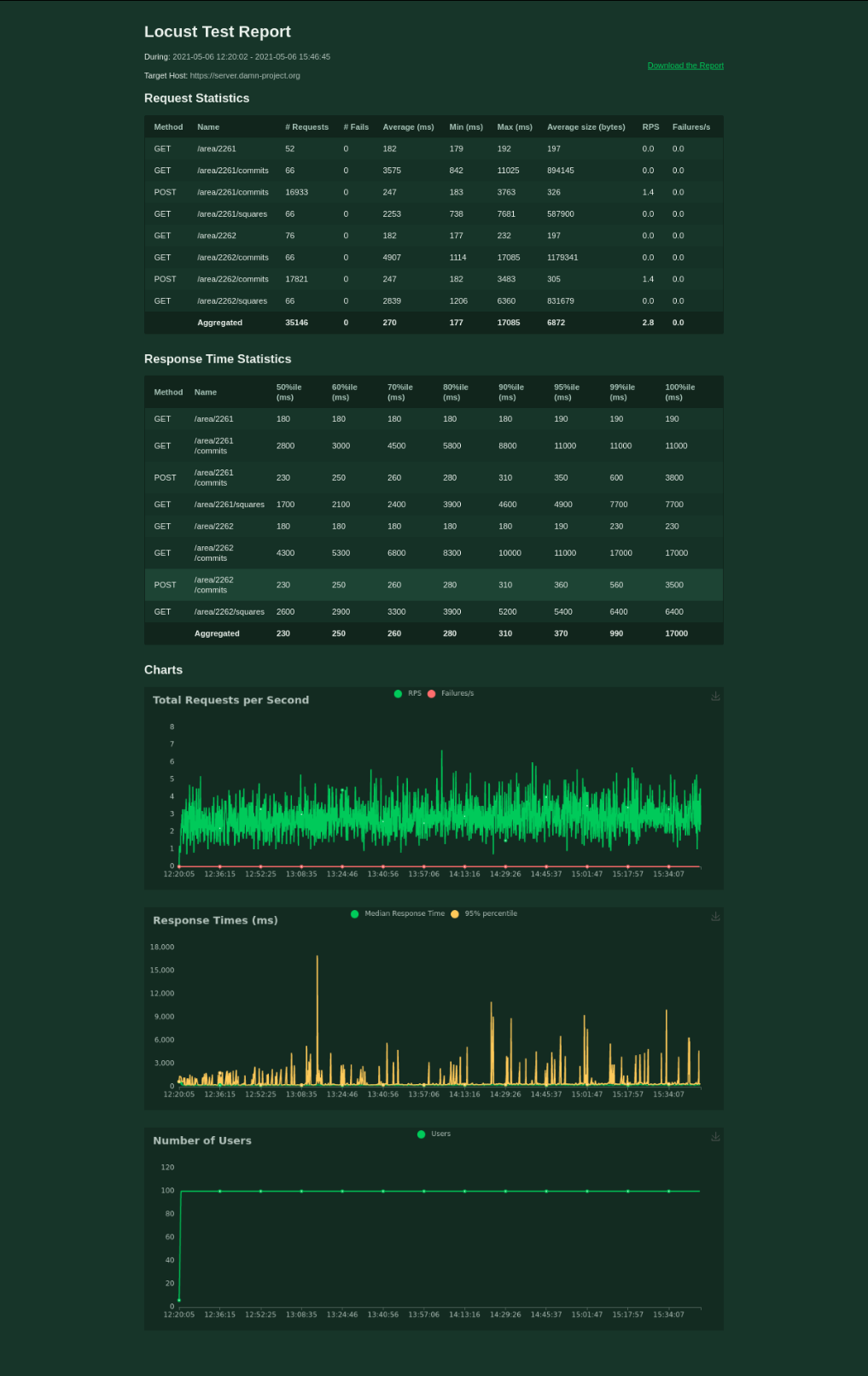
I use locust.io to load test the damn server. The test file is part of the repository. There is 80 % of mappers, 20 % of reviewers, and 2 testing areas. Each mapper/reviewer works for 30 - 60 seconds, then waits for 30 - 60 seconds, and then works again. All the mappers are spawned within the first minute. The test is stopped soon after there is 0 % to map for both of the areas.

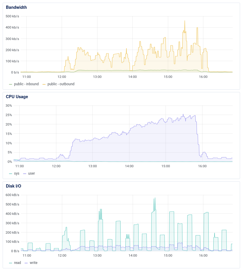
damn-project.org runs on $5/month VPS with 1 GB RAM, single 2.2 GHz vCPU, and 25 GB SSD disk.

100 mappers handled The first round of load testing gives the idea about the server after the refactoring. The average response time for 100 mappers is 270 ms. Not bad, I would say.

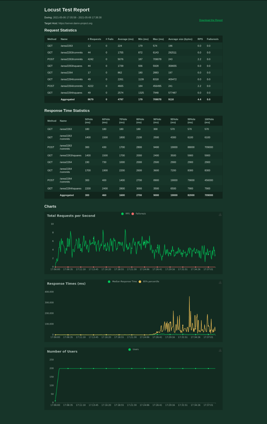
It’s a bit worse when testing 200 mappers, though. I’ve stopped the test after 20 minutes.

Some improvements Two years ago, I decided that there must be some better solution for the problem of dividing a big area into smaller squares. I found that there is PostGIS extension to PostgreSQL so I decided to go with it. Two year later (now,) I’ve discovered database indexes.

Also, I’ve read part of the documentation and set postgres parameters.

Finally, I switched gzip on.

See full entry

Quand j’ai commencé à cartographier en septembre dernier, j’ai eu la chance de rapidement tomber sur un territoire vierge dans OSM. Par territoire vierge, j’entends qu’il existe quelque chose sur le terrain mais qu’OSM n’en a pas connaissance. Aucun rendu ; visuellement, rien.

À vrai dire, j’étais tombé sur plusieurs zones très peu renseignées, mais il y avait toujours une petite trace de quelque chose. Ici, rien.

Ce qui m’a marqué dans ce cas-là, c’est qu’il s’agit d’un parc animalier touristique et qu’il n’est pas récent. Vous l’aurez deviné, c’est la Vallée des Tortues. Charmant parc animalier, modeste, pour petits et grands, qui se trouve à Sorède, non loin de la frontière espagnole.

🐢 http://www.lavalleedestortues.fr/

Si vous passez dans le coin, je vous invite à y faire un tour.

Au départ, donc, rien.

nada

See full entry

Location: Mas Pouater, Sorède, Céret, Pyrénées-Orientales, Occitanie, France métropolitaine, 66690, France
  • 2020년 08월 23일 : 회원가입…만 함.
  • 2021년 03월 29일: 최초 업로드, 첫 건물 작성 (상대동 시청 건물 인근)
  • 2021년 04월 11일: 첫 행정경계 작성 (진주시 5개 읍면동)
  • 2021년 04월 24일: 진주 외 경상권 첫 행정경계 작성 (양산시 1개동)
  • 2021년 05월 02일: 경상권 외 지역 첫 행정경계 작성 (고양시 2개동)
  • 2021년 05월 22일: 진주 외 지역 첫 건물 작성 (서울 종로 일부)

Overpass Turboを使用した、該当タグの検索方法 メモ
下記のリンクをクリック
https://overpass-turbo.eu/s/M1f

弘前市を検索する市名に変更
この例では、place=hamlet;place=quarter;place=neighbourhoodを検索している。

「実行」し、「エクスポート」でGeoJSONファイルでダウンロード。
GeoJSONファイルをJOSMで読み込み可能。
QGISのデータソースマネージャのベクターでも読み込み可能。

住所・地名の記入について place=hamlet は日本では現在あまり使われていないので注意
今後は以下で統一

*市 place=city
*町 place=town
*村 place=village
*大字 place=quarter
*小字 place=neighbourhood

Posted by sjorford on 25 May 2021 in English.

Added this new trail: osm.org/relation/12755086

https://www.hcpartnership.org.uk/south-cheshire-market-towns-trail-m

A short section through the Albion Locks housing estate needs surveying, as the development may have moved the footpaths. Also the paths through Brereton Heath nature reserve are lacking - from what I remember, the trees make GPS tracking difficult and many of the paths are no more than dirt tracks, but this is worth a visit.