 OpenStreetMap

Some street name are not confirmed. Still figure out.
Diary Entries in English
Recent diary entries
Posted by sarath sabarish on 24 June 2026 in English.

A while back I posted here about SafeStreets, a free walkability and pedestrian-safety scorer that runs on OSM for any address, with Nimman Road in Chiang Mai as the example. Since then the product has moved on in two ways that I thought I can share: the scoring model and how it reads OSM changed. My focus has shifted to the US, so most of what follows is about that, with a short note on the international path at the end.
What changed in the product
The first entry described an earlier model built around a Network Design component (35 percent) and an Accessibility component (25 percent), with greenery and destination access making up the rest. The composite is now four components on a 0 to 10 scale:
Daily Reach:40 percent. Proximity-weighted access to 7 service categories.
Street Safety: 30 percent. Now its own first-class component, a weighted-OR of a crossings grid against pedestrian separation, plus a speed-exposure proxy.
Transit Reach:15 percent. GTFS via Transitland, OSM stops as fallback.
Walking Comfort:15 percent. Sentinel-2 canopy, terrain, air quality (the one non-OSM component).
There is also a new 6-tier label on top of the number, from Pedestrian-first down to Hostile, so the score reads in plain language rather than just a figure.
How it reads OSM now
The bigger change is mechanical. In the first entry every score hit live Overpass inside an 800m and 1,200m query, which was slow and broke whenever Overpass rate-limited me. US scoring is now Overpass-free. I precompute the street and safety metrics from a planet extract onto an H3 resolution-9 grid (roughly 26 million hexes covering the US, about 0.1 km2 each), paired with a local OSM POI layer of around 2 million amenities. A US score is now a hex lookup plus a POI merge, no live API call.
The OSM tags doing the work, by component:
I’m deeply impressed by Openstreetmap. And by some very active contributors near Leuven. But, do we really need trams in our lovely tiny city?
Posted by ENGELBERT MODO on 22 June 2026 in English.

Hello OpenStreetMappers!
I am particularly proud to share with you today the complete results and highlights of the very first edition of the CityMapper Externship, held from April 10 to May 10, 2026, in Yaoundé, Cameroon.
Within the framework of the UN MAPPERS chapters initiative pilot project, I had the honor, as Ambassador, to lead this training, empowerment, and open data utilization initiative by young Africans to solve our challenges and improve the global map. This intensive immersion program was designed to train a new generation of urban mappers while producing open, sustainable, and high-quality geospatial data for our cities.
🛠️ One Month of Immersion: From Virtual Sprints to the Field Over four weeks, around thirty young people from French-speaking Africa (15 in-person in Yaoundé and 20 participating online from Togo, Senegal, and France) followed a progressive and intense path:
Initial Training: Mastering core open mapping tools (JOSM, HOT Tasking Manager, Mapillary, EveryDoor).
Remote Sprints: Mapping buildings and road networks across 8 HOT Tasking Manager projects linked to humanitarian missions.
Field Collection: Mapping the University of Yaoundé I campus and the city streets using EveryDoor and Mapillary.
If I’ve spare time to do this, I’ll do the update

I joined this site due to cycling. My tracking app (Strava) uses Open Street Maps. One of my cycling goals was to ride every street in my city, which is difficult enough without mapping errors. I kept seeing “roads” on this map that are in reality private driveways, “public” roads that are actually private, and some roads that exist in reality but aren’t on the map yet. (And in one case, a road on the map that has never existed in reality.)
I haven’t yet figured out how to accurately add missing roads, but I’m trying to make the map better by correcting these other features.

So this weekend (20/06 - 21/06) I went full mapper-mode around Chitlapakkam and Tambaram. Grabbed my phone, walked around the neighbourhood, spent hours on my laptop for mapping and ended up with 18 changesets and ~96 edits over two days. Honestly, some of this should’ve been there years ago.
🏛️ Civic & Government Infrastructure
Starting with the obvious ones. The T13 Police Station and the Tambaram MLA Office, two places people actually need to find were nowhere on OSM. Not a node, not a building outline, nothing. Fixed that.
Also noticed the Sembakkam Zone 3 MCC was still tagged as whatever it used to be. It’s a municipal transit yard now. Updated accordingly.
⛽ Fuel & EV Infrastructure
The Shell petrol complex nearby was not mapped and a bit of a mess. I added the following:
- The petrol bunk as a proper node
- The EV charging station within the complex
- The convenience store attached to the forecourt
Also quietly deleted a defunct petrol bunk that closed down a while back. It was still sitting on the map doing nothing. Gone now.
The EV charger is probably the most useful addition here OsmAnd, Organic Maps and other navigation apps pull charging locations from OSM.
🛕 Religious & Community Spaces
Two temples in Chitlapakkam that have been around forever, but not on OSM. At all. They are now. Also added some metadata to a spiritual centre that was on the map but barely tagged (This was one of my first edits in OSM, when I started it 3 months back !!)
Oh, and the outdoor kids’ play area inside Chitlapakkam Park? Mapped. Families use it every single day and it wasn’t showing up anywhere.
🏥 Health & Financial Services
Walked around the Chitlapakkam surroundings and found a bunch of medical shops, a pharmacy counter, and a few bank branches that were missing. These are the places people search for when they actually need them. Added them all from the ground survey.
🍽️ Food & Local Businesses

Validating the work of others is important. I was creative in doing just that.

Posted by Juergen Juffa on 20 June 2026 in English.
completed survey of all speed limits in an area south of Palatine Road, east of Wilke, west of Arlington Heights Road and north of Euclid/Northwest Highway. Updated street data on the map.
Posted by Raquel Dezidério Souto on 19 June 2026 in English.
Last updated on 23 June 2026.

IVIDES DATA® held the third session of the Ciclo de Oficinas OSM 2026 (or 2026 OSM Workshop Series), focusing on QGIS plugins. Applied cases were presented on accessibility, urban tree cover, and the geolocation of buildings on areas subject to disasters
 Dr. Raquel Dezidério Souto leading Session 3 of the Ciclo de Oficinas OSM 2026. The files used in Workshop 3 can be found in the video description. Link
IVIDES DATA® successfully held the third live training session of the Ciclo de Oficinas OSM 2026 on June 12, during which the following were presented:
* View and download data on OSM.org
* Access to geoservices for loading OSM as a base layer - NextGIS QuickMapServices plugin
* Downloading data in QGIS (version 3.22 or later) – QuickOSM and OSM Downloader plugins
* Applied cases — accessibility, urban tree cover, and the geolocation of buildings on areas subject to disasters

This is a very simple idea: given a set of GPX traces for a hike you are planning to take, generate a file containing all the waypoints of interest within the area covered by the GPX traces. I create a buffer around the GPX traces and extract the area from OSM. I define a set of tags of interest. I use Ollama with Mistral Nemo to make sure that POIs make sense to visit while walking on foot, as places are sometimes mislabeled in OSM. Before saving the waypoints to a GPX file, I use Ollama again to generate waypoint descriptions and set labels for each waypoint. Feel free to try it out! The code is on GitHub.

Mapping Sitka is pretty much my identity. I was upset when someone reverted my work because honestly I’ve been working every waking hour for a few months now. It was good though because I needed to step back and not take it too seriously. I’ve had some manic episodes late in life and they unlocked some anger I’m not familiar with. It was actually impressive how mad I got. Anyway, what are these diaries for if not a super personal post? Stay mappy people

Earlier today I had to check an alarm on the servers. The alarm was for a non-issue, but I happened to notice a momentary delay to replication across multiple services and I wanted to investigate.
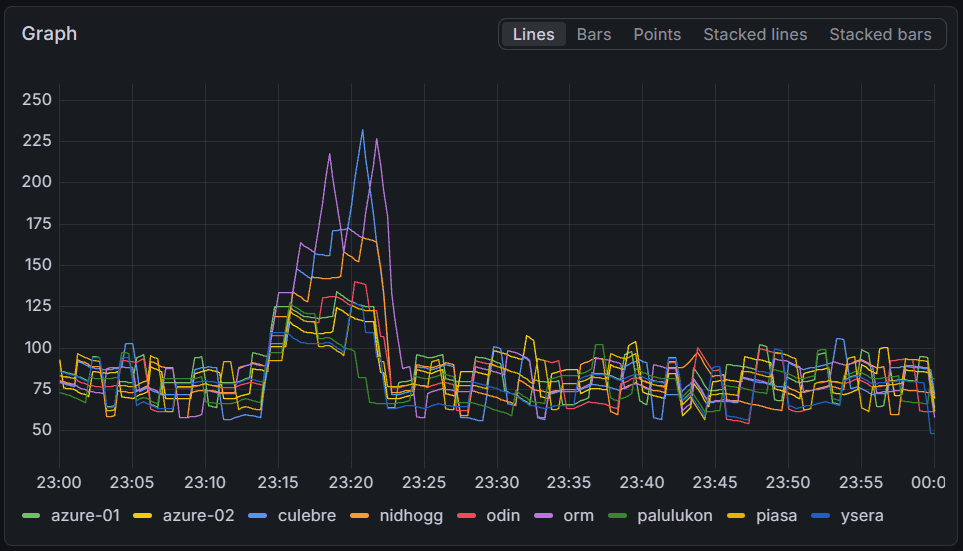
The rendering servers fell up to four minutes behind on some servers, with all servers falling at least a minute behind normal. Interestingly, there does not seem to be a correlation between the delay and the server capacity.
Posted by Raquel Dezidério Souto on 17 June 2026 in English.
Editora IVIDES has published the Swahili translation of the FPOSM booklet on the ODbL license

Download SW VERSION
The original work Tout savoir sur la license ODbL : la licence d’OpenStreetMap pour cartographier en commun was written in French in 2024 and updated in 2026 by the Fédération des Pros d’OSM, a French organization that brings together various companies and professionals working with open data, OpenStreetMap, and related software. The authors of the original booklet are: François Lacombe (Datactivist), Florian Lainez (Jungle Bus), Antoine Riche (Carto’Cité) and Christophe Biez (Latitude-Cartagène Cartographies).
The translation to Swahili was done by Hemed Lungo and Tatu Sultan Lungo, from Tanzania, and the booklet was edited by Raquel Dezidério Souto (Editora IVIDES).
The work is licensed under the Creative Commons Attribution-ShareAlike 2.0 France (CC BY-SA 2.0 FR). Text of the license
Download EN VERSION
Download VERSÃO PT

I’ve been reflecting on the balance between mapping for ‘volume’ and mapping for ‘precision.’ While I understand the value of quick, large-area edits for global visibility, I find it a bit puzzling when polygons are generalized to the point of overlapping everything in sight—especially when high-resolution imagery is available.
I’ve noticed a trend where edit counts are sometimes treated as the ultimate metric of a mapper’s worth. I reckon we should be careful not to let the pursuit of ‘top contributor’ stats overshadow the primary goal of creating a detailed, accurate map for everyone. For me, a well-traced building or a correctly aligned path is worth far more than a high edit count achieved through imprecise mass-mapping. I’m always keen to learn the best practices, so if there’s a standard way to maintain precision while contributing efficiently, I’m all ears. Cheers.
.jpg)
Waiting for someone to do Portland on OHM. About 90% of the people reading this will go “What is Open Historical Map!?”. It’s sadly never used… I wish it was updated more often…
State of the Map US 2026 Presented by OpenStreetMap US was this weekend in Madison, Wisconsin. As any good breakfast lover, I tried to seek out the best breakfast food in the area of Capitol Square. Here’s my thoughts:
Friday: Wonderstate Coffee (on OSM)
This is a very modern looking coffee shop (think crisp whites and light woods - if Apple had a coffee shop) with a great seating area outside overlooking the Capitol Square and is in a very nice spot to be shaded in the morning to enjoy your coffee or small food item. Only downside to sitting outside is you are very close to the road - but that’s to be expected in a downtown area.
I ordered a plain bagel and cream cheese, and an iced coffee with cream and sugar. Typically where I am this means drip coffee poured over ice, but the barista recommended an Americano… when in Rome I suppose. The coffee was delicious, and the bagel came out with more cream cheese than I think I have ever seen on a bagel (not complaining! Just surprising!)
Cost: $9.23 Rating: 7/10
Saturday: Marigold Kitchen (on OSM)
Such a cute spot! I was searching this day for a good omelette and this place seemed highly recommended. The feel was much more artsy coffeehouse vibe, plenty of lighting and a small outdoor seating area, but I ate inside. I was greeted and handed a menu at the door, ordered at the counter, and was recommended the pancakes as well as the omelette if I was hungry enough. Very friendly staff throughout even during what was clearly an elevated breakfast rush with the farmers market getting started just outside!
Posted by Paco Albacete Chicano on 13 June 2026 in English.
Hi again!
In my previous diary entry I introduced myself and my GSoC project with Valhalla, and I mentioned we were still putting the finishing touches on the exact main goal. Now we have it! We’re focusing on area routing. This is basically means making the router cross open pedestrian areas (like squares) instead of walking around them and generating weird and inefficient routes. This diary entry is a deep dive into the research I’ve done while exploring the different options.
The problem with pedestrian areas
When you ask a router to go across a square, you would expect it to cross it like any person would. But a lot of routers don’t do that, they may send you around the perimeter or go along the streets surrounding the square. The problem here is that the open area has no “ways” inside of it to travel on.
Let’s see one example (using Valhalla) on Plaza Santo Domingo in Murcia (my hometown!):


Please help me raise funds to purchase the missing sheets from the complete historical 1:50,000 topographic map series of Zimbabwe, formerly Rhodesia.
https://gofund.me/f12d5f3d2
Donate and more information at https://www.gofundme.com/f/purchase-historical-zimbabwe-topographic-maps
Previous donation drives:
- Namibia (South West Africa) - 2008 - https://namibia-topo.openstreetmap.org.za/
- Eswatini (Swaziland): - 2015 - https://eswatini-topo.openstreetmap.org.za/
In the unlikely event that any funds remain after purchasing the Zimbabwe map sheets, they will be used to buy missing sheets from the Lesotho or Malawi 1:50,000 topographic map series, which are planned as future projects.

If you use the amazing better-osm-org browser extension/userscript to review changesets, you are probably familiar with its default red, green, and yellow diff highlighting.
While the default colors are great, sometimes you want a custom color scheme that feels more comfortable for your eyes during long validation sessions. For instance, changing the added tags to a cool cyan, keeping deleted tags red, and making modified tags a soft cream/yellow.
Since the script dynamically manages light/dark themes, the easiest way to override these colors globally without messing up the extension’s code is by using custom CSS via the Stylus extension.
How to Apply It:
- Install the Stylus extension (Chrome/Firefox/Edge).
- Go to openstreetmap.org.
- Click the Stylus extension icon and select ”(+) Write style for: openstreetmap.org”.
- Paste the CSS code below into the editor, give it a name (e.g., Better OSM Custom Colors), and hit Save.
The CSS Code:
/* 1. MODIFIED TAGS -> SOFT CREAM / YELLOW */
    tr.quick-look-modified-tag th,
    tr.quick-look-modified-tag td {
        background: rgba(255, 235, 150, 0.7) !important;
        color: #000000 !important;
    }

/* 2. DELETED TAGS -> RED */
    tr.quick-look-deleted-tag th,
    tr.quick-look-deleted-tag td {
        background: rgba(238, 51, 9, 0.6) !important;
        color: #000000 !important;
    }

/* 3. NEW TAGS -> CYAN */
    tr.quick-look-new-tag th,
    tr.quick-look-new-tag td,
    tr.quick-look-added-tag th,
    tr.quick-look-added-tag td {
        background: rgba(0, 200, 220, 0.6) !important;
        color: #000000 !important;
    }