OpenStreetMap logo OpenStreetMap

Users' Diaries

Recent diary entries

前言

这些随想是在去年年底写的,也许对其他 mapper 有启发,故发布。

慎画密集的住宅区

卫星地图上密集的住宅区(不规则的房子、看不清的小巷),除非亲自走访、亲自记录,否则最好不要画
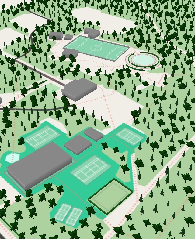
不要无限细化

刚画 osm 时,很容易被卫星地图里的各形各色的东西吸引注意力,导致无限细化,也就是说在一小片地方死抠细节。

若画小范围的地方(比如学校、公园等),无限细化无所谓。但画大范围的地图还无限细化的话,这得画到猴年马月?而且还会打消画 osm 的兴趣。

所以画大范围的地图,在保证效率的同时,还要表达准确。这件事不容易完成。

画 osm 的难点在于:怎么把卫星图像上的东西,提炼成精准、简洁的符号

请参考 osm 极简画法

Kontribusi Perempuan dalam Pemetaan Dunia

Keberadaan perempuan di dunia kartografi dan pemetaan saat ini semakin terlihat dan jumlahnya terus bertambah. Kontribusi mereka memberikan nilai yang sangat berharga bagi perkembangan data geospasial. Meski demikian, dalam dunia pemetaan sukarela seperti OpenStreetMap (OSM), jumlah pemeta perempuan masih lebih sedikit dibandingkan laki-laki. Padahal, peran pemeta perempuan sangat krusial untuk meningkatkan inklusivitas data, terutama dalam melengkapi informasi fasilitas publik yang spesifik bagi perempuan, seperti ruang laktasi dan toilet umum.

Dasar-Dasar Pemetaan di OpenStreetMap Sebelum mulai berkontribusi, ada beberapa konsep dasar yang perlu dipahami agar data yang dihasilkan akurat dan bermanfaat:

Konsep Objek di OSM:

  • Titik (Nodes): Menandai lokasi spesifik.
  • Garis (Ways): Untuk objek seperti jalan atau sungai.
  • Area (Poligon): Untuk batas bangunan, taman, atau wilayah.
  • Relasi (Relations): Untuk menghubungkan objek-objek yang kompleks.

Sistem Tagging (Atribut Data): Pemberian label informasi pada setiap objek.

Sumber Data yang Legal:

  • Citra Satelit yang diizinkan.
  • Survei Lapangan langsung.
  • Data Pemerintah yang bersifat terbuka.

Alat Pemetaan (Editor):

  • A list item with additional text
  • iD Editor (Berbasis web, ramah pemula).
  • JOSM (Untuk penyuntingan tingkat lanjut).
  • StreetComplete (Aplikasi seluler untuk pemetaan praktis).

Hal Penting Sebelum Melakukan Digitasi Kemampuan membedakan objek seperti jalan, bangunan, badan air, dan vegetasi adalah inti dari interpretasi citra. Tanpa kemampuan identifikasi yang tepat, data hasil digitasi tidak akan memiliki nilai informasi yang benar. Terakhir, diperlukan kerelaan hati dalam memetakan. Tujuan utama OpenStreetMap adalah menciptakan basis data peta dunia yang gratis, terbuka, dan kolaboratif. Ingatlah bahwa kontribusi ini bersifat sukarela tanpa imbalan materi, namun sangat berdampak besar bagi kemanusiaan dan akses informasi dunia.

See full entry

Location: Sumberagung, Krecek, Badas, Kabupaten Kediri, Jawa Timur, Jawa, 64219, Indonesia
Posted by pussreboots on 2 May 2026 in English.

Arbuckle is a small community of about 3500 people in southern Colusa County. My husband and I stop through there a few times a year as we head north. It has gas stations and a fantastic Mexican restaurant on 5th street.

So it seemed like a good place to focus on mapping. I have about 100 homes left on the north west corner of the community. I started the project in January on business trip to Chico.

Location: Arbuckle, Colusa County, California, 95912, United States

Ungkapan bahwa kehidupan itu “kadang naik kadang turun, kadang kaya kadang miskin” adalah metafora roda kehidupan yang terus berputar. Ini menggambarkan fluktuasi nasib manusia yang tidak abadi, di mana seseorang tidak selamanya berada di atas (sukses/bahagia) atau di bawah (terpuruk/kesusahan). 1. Filosofi Roda BerputarKetidakabadian: Situasi saat ini, baik itu kejayaan maupun kesulitan, adalah sementara.Ujian Kehidupan: Kaya dan miskin adalah bentuk ujian untuk melihat siapa yang bersyukur dan bersabar.Perubahan Nasib: Seseorang yang hari ini kaya bisa saja jatuh miskin, dan sebaliknya, yang miskin bisa menjadi kaya.

  1. Sikap Saat di “Atas” (Kaya/Sukses)Tidak Sombong: Jangan merasa angkuh atau lupa diri karena posisi bisa berubah kapan saja.Berbagi & Bersyukur: Kekayaan adalah kesempatan untuk berderma dan membantu sesama.Tetap Membumi: Sadar bahwa semua hanyalah titipan.

  2. Sikap Saat di “Bawah” (Miskin/Terpuruk)Bersabar & Tegar: Tidak putus asa karena kesulitan adalah bagian dari proses pendewasaan diri.Berusaha & Berdoa: Tetap berjuang karena roda akan berputar kembali.Fokus pada Solusi: Orang dengan mental tangguh akan mencari peluang, bukan meratapi keadaan.

  3. Hikmah di Balik Perputaran Keseimbangan: Adanya kaya dan miskin diciptakan agar roda kehidupan berputar dan manusia saling membutuhkan.Pembelajaran: Pengalaman di titik terendah seringkali melahirkan ketangguhan dan kerendahan hati.Ketenangan Hati: Memahami bahwa “semua akan berlalu” membuat seseorang lebih tenang menghadapi penderitaan.

Secara ringkas, kunci menghadapi roda kehidupan yang berputar adalah bersyukur saat berada di atas, dan bersabar saat berada di bawah.

Location: Pancaran, Pare, Kabupaten Kediri, Jawa Timur, Jawa, 64211, Indonesia

While browsing Taginfo I got curious how many elements have at least one key described on the Wiki and how big share of all keys the described ones make up. Therefore, I decided to check it out.

The analysis consisted of the following parts:

  1. fetching OSM database dump from planet.osm.org;
  2. fetching key statistics from Taginfo with the API;
  3. extracting “is in Wiki” info into separate file;
  4. altering “is in Wiki” info for keys which were described on the Wiki after the database was dumped. The alteration was based on the recent changes registry;
  5. processing the dump with DuckDB:
    • extracting element type, its ID, and its tags to new table: CREATE TABLE elements AS SELECT kind, id, tags FROM ST_READOSM('planet-latest.osm.pbf');;
    • exploding keys to separate records: CREATE TABLE elements_keys AS SELECT kind, id, UNNEST(map_keys(tags)) FROM elements;;
  6. querying the database.

These are queries I provided to DuckDB:

Result Query
number of all elements SELECT COUNT(*) FROM elements;
number of tagged elements SELECT COUNT(*) FROM elements WHERE tags IS NOT NULL;
number of elements with key(s) described on the Wiki SELECT COUNT(*) FROM (SELECT DISTINCT kind, id FROM elements_keys WHERE "key" IN (SELECT "key" FROM 'keys_wiki.csv' WHERE in_wiki));
number of all keys SELECT COUNT(*) FROM (SELECT DISTINCT "key" FROM elements_keys);
number of keys described on the Wiki SELECT COUNT(*) from (SELECT DISTINCT "key" FROM elements_keys WHERE "key" IN (SELECT "key" FROM 'keys_wiki.csv' WHERE in_wiki));

I got the following results:

See full entry

Dans OpenStreetMap, il arrive souvent que des amphithéâtres soient mal tagués comme des universités. Cela crée des incohérences dans les données et peut fausser les usages (cartes de campus, analyses, routage interne, etc.).

Pour les trouver on peut utiliser la requête OverPass ci-dessous :

[out:json][timeout:25];

area["name"="Toulouse"]["boundary"="administrative"]->.a;

(
  node["amenity"="university"]["name"~"Amphi|amphi|Amphithéâtre|amphithéatre"](area.a);
  way["amenity"="university"]["name"~"Amphi|amphi|Amphithéâtre|amphithéatre"](area.a);
  relation["amenity"="university"]["name"~"Amphi|amphi|Amphithéâtre|amphithéatre"](area.a);
);

out body;
>;
out skel qt;

Liebe Community,

hiermit würde ich Sie gerne darüber informieren, dass wir in Zukunft versuchen Bremerhaven und die Umgebung besser zu kartieren. Gleichzeitig dient dieser Post somit der offiziellen Ankündigung.

Wir sind bemüht jegliche Änderung/Verbesserung so gut wie möglich darzustellen, damit dieser der Realität entsprechen.

Vielen Dank

A empresa IVIDES DATA® está com inscrições abertas para o seu ciclo de oficinas OpenStreetMap 2026


post_curso


100% ON-LINE. Haverá 5 encontros de 15 em 15 dias - 08/05, 22/05, 05/06, 19/06 e 03/07 (sextas-feiras), 14 às 16h (UTC-3), contemplando diferentes temas:


* Mapeamento com OpenStreetMap
* Plugins para QGIS
* Formulários Web com KoboToolbox
* Mapas Web com uMap


Nível: para mapeadores de todos os níveis.


Perfil da professora:


See full entry

Location: Santa Cruz, Rio de Janeiro, Região Sudeste, Brasil
Posted by skaringa on 29 April 2026 in German (Deutsch).

Karte der Flussgebiete Mitteleuropas

Die Karte der Flussgebiete Mitteleuropas erstelle ich nunmehr seit 13 Jahren aus OpenStreetMap Daten. In dieser Zeit gab es viele kleinere und größere Verbesserungen an der Software und an der Datenbasis. Geblieben ist das Grundprinzip: Der Algorithmus traversiert Wasser-ways und verbindet sie anhand gemeinsamer nodes zu Flussgebieten. Ein Renderer erstellt daraus eine Karte mit entsprechend dem Flussgebiet eingefärbten Wasserwegen (Details).

Das fortgeschrittene Tagging von Wasserweg-relations mit type=waterway erlaubte die Implementierung eines oft gewünschten Features: Ein Klick auf ein Element hebt den kompletten Wasserlauf von der Quelle bis zur Mündung hervor und zeigt Informationen zum Wasserweg an (siehe Bild).

Vielen Dank an alle, die durch Hinweise, Verbesserungsvorschläge und insbesondere die Pflege der Daten in OSM an diesem Projekt mitgearbeitet haben!

Kontribusi Wanita dalam Pemetaan Terbuka Level Street View

Peran wanita dalam dunia professional selama ini sering kali dianggap remeh oleh beberapa orang. Hal ini dikarenakan oleh adanya stigma bahwa wanita baiknya menjadi ibu rumah tangga mengurus anak dan permasalahan rumah tangga. Sebaliknya tugas pria adalah mencari nafkah dan pundi-pundi uang untuk keberlanjutan keluarga. Namun, di zaman modern ini pandangan seperti itu sudah dianggap kuno dan kurang relevan semenjak banyaknya teknologi yang telah dikembangkan untuk mempermudah wanita dalam beraktivitas seperti pria. Apalagi sudah banyak perkerjaan yang hanya bisa dikerjakan oleh wanita.

Dalam dunia survey lapangan, pandangan orang pada saat ini pun masih berkutat bahwa ini adalah pekerjaan yang berat dan lebih cocok dikerjakan oleh pria dibanding wanita. Tetapi Pandangan seperti itu pun sepertinya sudah banyak terbantahkan oleh beberapa wanita yang ikut banyak terjun ke dunia survey dan hasil kinerja mereka sangat baik tidak kalah dari kinerja yang dilakukan oleh pria.

See full entry

Location: Sukawana, Cisarua, Bandung Barat, Jawa Barat, Jawa, 40551, Indonesia

Seperti yang kita ketahui, perempuan sering menjadi sasaran tindak kejahatan, baik dari orang di sekitar maupun dari orang yang tidak dikenal, terutama di ruang publik. Kondisi ini menyebabkan perempuan sering merasa tidak aman saat berada di jalan, menggunakan transportasi, maupun di tempat umum lainnya, baik pada siang maupun malam hari. Terjadinya aksi kejahatan itu, dipicu oleh kurangnya imformasi mengenai wilayah yang aman, dan wilayah yang tidak aman, minimnya penerangan jalan, serta kurangnya pengawasan di beberapa lokasi semakin meningkatkan risiko yang dihadapi perempuan. Oleh karena itu, diperlukan upaya yang terarah melalui peningkatan keamanan, penyediaan informasi yang akurat, serta pemanfaatan pemetaan digital menggunakan OpenStreetMap, kegiatan ini meliputi identifikasi area yang aman, dan area yang beresiko akan munculnya tindak kejahatan.

Location: Mota Ulun Oeste, Nain Feto, Dili, Timor Leste

I often need to create a single GPX file from multiple related but different GPX files from Garmin and Wikiloc. My use case is finding route recommendations for running based on GPX files. I try to get a single GPX file so I do not have to juggle multiple files during the run. Original GPX files are also noisy, so the added advantage is having a precise path to navigate instead of dealing with GPX noise.

I start by putting all downloaded GPX files into a single directory and plotting them on the map. This step allows me to see them in relation to each other and spot any outliers early. I then simplify each GPX file to reduce the number of points and match them to OSM ways. I filter the points to make them evenly spaced. Finally, I use the OSRM trip service to create a single combined GPX file, or fall back to the minimal number of split files if they cannot be merged into a single file. I plot the resulting GPX files and simplify them to reduce the point count. Now I can sync them to Garmin and use them as a kind of basemap on a device that does not support basemaps.

Of course, this only works when I know the area in advance, can find enough existing route recommendations, and there is a reasonably complete OSM map. The current pipeline is error-prone and I find myself tweaking it to make it work with any specific set of GPX files. You can try it yourself and view the complete code on GitHub: https://github.com/evgeniyarbatov/gpx-courses

Location: Hong Ha Ward, Hà Nội, 11025, Vietnam
Posted by NieWnen on 28 April 2026 in English.

Regional osm2pgsql updated minutely as an alternative to Overpass.

Short version:

Recently, I wrote a script that could help with OSM DB data replication using osm2pgsql by filtering .osc files with a specific .poly. It doesn’t limit to a specific continent or country, it can be used with any custom PBF (e.g. a specific city), so it doesn’t need to use .fr replication, it uses planet.osm.org directly (which also could be changed).

It’s inspired by the trim_osc.py script by Zverik, but rewritten from scratch with tests, because the script unfortunately didn’t work for me (maybe I did something wrong).

It’s not a very typical thing, so I’m not sure if it will be useful for anyone, but if someone would like try to self-host a regional OSM DB with replication, I recommend to at least checking it.

More details in the repo: osm-replication-osc-poly-filter

Longer version:

A few months ago, I was looking for an alternative for public Overpass instances (due to overloaded servers) for my projects.

I read SomeoneElse’s diary about self-hosting Overpass instance. But it seems over-complicated to me. I also read many times that there are random issues with reliability and it’s time-consuming to maintain it (not sure how true it is).

I decided that I want to switch to something else for my projects. Something more low-level with greater control of data and more likely self-hosted to avoid such problems. Instead of OverpassQL. I switched to SQL with a PostGIS DB. There are no a lot of choices here, so I chose osm2pgsql.

Osm2pgsql is quite advanced tool, which I really recommend at least reading about it – it may require some time to learn it, but it’s worth to seeing some features like --output=flex, which allows to defining custom table schemas in Lua scripts with tags/geometry columns which works when importing and appending (replicating) data. It can be adjusted and optimized per project.

See full entry

1,934 Unreviewed TIGER Road Segments Are Breaking Public Transit in Hamilton County

SORTA operates MetroNow, a microtransit service covering four zones in Hamilton County: Blue Ash/Montgomery, Springdale/Sharonville, Northgate/Mt. Healthy, and Forest Park/Pleasant Run. The service is powered by Via Transportation, whose routing engine consumes OpenStreetMap as its base map layer.

I am a daily MetroNow rider. A persistent routing failure at my address led me to inspect the OSM data that Via’s routing engine depends on. What I found on one street turned into a zone-wide audit. The results are significant enough that I want to share them with the local OSM community and ask for help.

The Street-Level Problem

A residential street in the Blue Ash zone carries two defects from the TIGER/Line 2008 Census import. Both carry tiger:reviewed=no. No human has verified this data since import.

  1. False oneway=yes tag on a two-way residential dead-end street. The false one-way tag makes the routing engine calculate entry with no legal exit. The engine marks the street as unreachable. Drivers get redirected to a neighboring street. Riders get circuitous routes that bypass the correct address entirely.

  2. Disconnected node gap at a cross-street intersection. Two ways representing the same street do not share a node. The routing graph treats the street as two separate, disconnected segments.

For a transit-dependent rider with mobility limitations, a routing failure is not an inconvenience. It is a service denial.

The Zone-Wide Data

I ran the following Overpass query across the Blue Ash/Montgomery zone:

[out:json][timeout:90];
way["highway"]["tiger:reviewed"="no"]
  (39.16,-84.44,39.24,-84.33);
out tags;

Results:

See full entry

Location: Rossmoyne, Sycamore Township, Hamilton County, Ohio, 45236, United States

Ces derniers jours, j’ai cherché à améliorer le mapping des quartiers de Genève dans OpenStreetMap.

Méthode OSM

OpenStreetMap représente les quartiers de Genève de deux manières principales :

  1. Par des ways et des relations dessinant les frontières (tags typiques : boundary=, admin_level=).
  2. Par des “nodes” (noeuds) indiquant leur emplacement approximatif (place=*).

Ce mapping se concentre sur la deuxième approche: les “nodes” place=*.

Les “nodes” place=* se classent généralement par échelle croissante :

Couverture ailleurs

Les noms de quartier apparaissent ailleurs : subdivisions du territoire, voies et places, arrêts TPG, écoles primaires, locaux de vote, secteurs statistiques, etc. Ils sont souvent déjà présents indirectement dans OSM.

La Ville publie la page “Découvrir Genève et ses quartiers” avec les quartiers suivants:

  • Eaux-Vives — Cité
  • Servette — Petit-Saconnex
  • Plainpalais — Jonction
  • Acacias — Bâtie
  • Champel
  • Grottes — St-Gervais
  • Pâquis — Sécheron
  • St-Jean — Charmilles

Le SITG (et le registre foncier) donnent une subdivision de base en quatre “communes”:

Leurs frontières ne sont pas présentes dans OSM.

Cette subdivision est basée sur les anciennes communes que la ville a absorbées en 1931:

Le site Noms géographiques du canton de Genève décrit en général le quartier d’après lequel une voie est nommée.

La collection d’iconographie de la Bibliothèque de Genève (BGE) est également indexée par quartier.

Le site Genève-archi utilise les 4 communes et des secteurs dessinés sur fond de carte OSM.

Les wikis (articles et liste Wikipedia, Wikimedia, Wikidata) incluent certains et les combinent parfois. Même si les trois wikis sont reliés entre eux, ils ne se réfèrent pas forcément au même lieu.

Liste des quartiers

Voici un extrait:

See full entry

Location: Grottes et Saint-Gervais, Genève, Suisse