OpenStreetMap logo OpenStreetMap

Users' Diaries

Recent diary entries

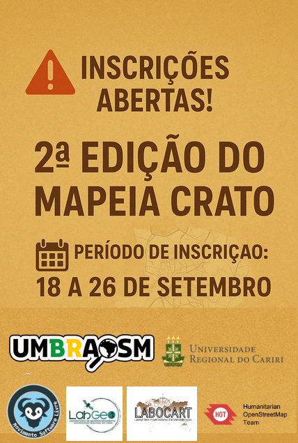
🗺️ Mapeia Crato – 2ª Edição

As inscrições já estão abertas! 🎉

https://doity.com.br/mapeiacrato2edicao

📌 Participe dessa jornada de mapeamento colaborativo no OpenStreetMap e ajude a transformar o território do Cariri através do mapa livre e aberto.

✅ Capacitação aberta para iniciantes e experientes ✅ Suporte para quem nunca usou o Editor JOSM ✅ Certificado de Participação para todos os inscritos ✅ Apoio: Movimento Software Livre (MSL) e HOTOSM

👉 Garanta já sua inscrição e venha mapear com a gente!

Location: -13.411, -47.637

– only in Portuguese

IVIDES DATA oferece um conjunto de três oficinas de mapeamento no OpenStreetMap


As oficinas visam a capacitação em mapeamento de feições no OpenStreetMap, utilizando os dois editores mais populares.


A primeira oficina foi realizada virtualmente em 18 de setembro de 2025 e os próximos encontros estão programados para 02 e 15 de OUTUBRO de 2025, sempre de 19h às 21h UTC-3.


Confira a programação:


- Mapeamento de caminhos no OpenStreetMap com editor iD - 18-09-2025


- Mapeamento de áreas no OpenStreetMap com editor JOSM - 02-10-2025


- Validação com o editor JOSM - 15-10-2025


Esta ação não tem formulário de inscrição, as sessões são abertas e transmitidas AO VIVO.


Acompanhe as sessões que estão sendo transmitidas AO VIVO E ABERTAS AO PÚBLICO pelo canal IVIDES no YouTube.


Os(as) participantes enviam os seus resultados por e-mail e realizando corretamente as tarefas, receberão um certificado de treinamento de 4h de carga horária.


Aproveite esta oportunidade de aprender profundamente sobre o mapeamento no OpenStreetMap. O conteúdo abrange questões muito além do que está nos manuais já publicados.


See full entry

Dear diary,

Yesterday, I was in a meeting of the HOT QCQA WG, when Patrik_B asked a question at the very end of the meeting. How can you download select data within a given complex geometry via overpass; the geometry in the JOSM layer isn’t visible when downloading?

The Objective

 Download all desired data via overpass within this boundary.  Bulape Health Boundary in JOSM Fig.1. Area of Interest.

Download Along to Highlight the Boundary of the AOI on the Slippy Map

Ralph was first to answer the question. His solution was to download data from OSM using the download along plug-in. The area of downloaded data would then be visible on the slippy map and this could be referenced when drawing a bounding box to download the data. Very clever.

See full entry

🚨 Inscrições Abertas! 🚨 👉 Vem aí a 2ª Edição do Mapeia Crato – CE 2025.

A 1ª edição foi um sucesso 🎉 Contamos com a participação de 15 alunos, 2 professores coordenadores, além de membros da comunidade OpenStreetMap Brasil e da UMBraOSM.

Agora é a sua vez de fazer parte dessa iniciativa! Participe da 2ª edição e ajude a mapear o Crato de forma colaborativa.

📅 Período de inscrição: de 18 a 26 de setembro 🔗 Inscreva-se agora: doity.com.br/mapeiacrato2edicao

See full entry

According to the official statistics page, today OpenStreetMap has hit the milestone of 10 million registered users! This is not the first time though; in fact it already happened earlier this year and in 2023 (during which year the amount even exceeded 11 million!); lately, the number of registered users graph shows a saw-tooth pattern, probably, in my opinion, due to the SPAM accounts being continuously banned by the admins.

By the way, if you happen to have an account on OSM wiki, please check the translation of Template:Contributors/count in your language as it may need to be updated. That template is pretty simple but it’s used by a couple of “main” wiki pages.

However, the number seems pretty high, but it may be worth noting that only about 23% (~2.25 million) of the total number of registered users has made at least one modification in the OSM database. Considering that the database has received 17 billion¹ edits, that means that every contributor has made an average of 7,400 changes from their entire lifespan as a user (you can see how many contributions you made on your HDYC page).

One last question that’s been bothering me: how many users would be registered on OSM if no one had been deleted or banned? Well, according to the API, at the time of writing, the last valid user id is 23,302,305 so the answer is more than double the number of currently registered users.

Imagine what could be achieved with twice as many contributors!

¹ number calculated using the file changesets.osm dated 2025-04-07 (license ODbL 1.0); the values shown here are unverified and may be incorrect.

Happy mapping to all 10 million users!

Location: Bankside, Southwark, London Borough of Southwark, Greater London, England, SE1 9TG, United Kingdom
Posted by Scarbaci on 17 September 2025 in English.

I joined OSM from the https://deflock.me/ community, and have since added 21 ALPRs. I’ve also contributed a few new developments to the map, and looking to add more.

GIS has been a huge interest of mine, and I’ve been maintaining my own private ATAK repository for a while. I’m excited to find a place to share this knowledge now. When I was younger, I would systematically walk areas of Baltimore, MD looking to uncover interesting POI. I wish I had OSM back then to store my findings.

Location: Margaretta Township, Erie County, Ohio, United States
Posted by Jiri Podhorecky on 16 September 2025 in Czech (Česky). Last updated on 31 October 2025.

Když mapuji venkov, nejde mi jen o kreslení čar a bodů na monitoru. Skutečné poznání míst přichází teprve venku, na čerstvém vzduchu. Na jihu Čech – mezi Blanským lesem a Šumavou, nebo v Pomalší – jsem si ověřil, že je pořád co objevovat.

Co se dá zjistit vlastníma očima

Častokrát mi stačí obyčejná vycházka nebo okružní jízda na kole. Všimnu si třeba lesní cesty, která není vyznačená, nebo kapličky zarostlé v křoví. Občas si fotím rychlé momentky – ne kvůli kráse snímku, ale jako připomínku co nezapomenout. Doma pak na mapě projdu trasu a doplním drobnosti, které jsem viděl.

Nikdy se nevracím naprázdno. Nejčastěji mne překvapí charakter místa, který prostě vzdáleně z mapy nepřečtu. Například když je celá obec na šikmém svahu a tedy i náves je mírně z kopce. Je to důležité? Nevím, někdy ne, ale někdy možná ano. Tyto postřehy mi propojují mapu s trvalou pamětí místa.

Názvy, které nikde nenajdu

Některé místní názvy nejsou oficiální, ale vžily se, takže lidé vědí, o čem je řeč. V Českém Krumlově je například kus chodníku, spojující sídliště Vyšný a vlakové nádraží. Lidé co tu žijí delší dobu, stezce říkají Močka. Myslím že přijde čas ji tak označit. Tyto znalosti se předávají běžným vyprávěním. Chce to čas a trpělivost – někdy při posezení u piva, jindy jen tak mezi řečí. Odměnou jsou ale postřehy, které žádný úřad nezaznamenal.

Když promluví sousedi

Jiným způsobem se dají zapojit i celé komunity. Sdílel jsem třeba fotku ukazatele u Svatého Jana nad Malší – jen obyčejný snímek, který by sám o sobě mapě nepomohl. Ale v internetové skupině se hned rozproudily reakce: že ukazatel byl původně jiný, pak byl upravený a přepsaný do dnešní podoby. Najednou se vidělo, že má pro lidi nějakou historii, vývoj, a pro mne prvek na mapě získal svůj kontext. Někdy se díky tomu řeč stočí k dalším nezmapovaným tématům. A já si je ověřím na další cestě.

See full entry

Location: Hořice na Šumavě, okres Český Krumlov, Jihočeský kraj, Jihozápad, 382 22, Česko

I’ve been editing OSM for about nine months and have been a heavy JOSM armchair editor for about eight months. Recently, I started using a stylus for entering geometry and it’s increased my stamina tremendously. I’ve been able to create hundreds even thousands of nodes per day without feeling any signs of repetitive strain injuries cropping up in my hand.

Posted by dcapillae on 16 September 2025 in Spanish (Español). Last updated on 21 September 2025.

Los stolpersteine son adoquines conmemorativos que rinden homenaje a las víctimas de los campos de concentración nazis. Esta mañana pasé por el pueblo de Almogía para fotografiar tres stolpersteine que se inauguraron el pasado sábado, 13 de septiembre, en memoria de tres vecinos del municipio que fueron deportados durante la segunda guerra mundial.

Adoquines conmemorativos Adoquines conmemorativos en Almogía (ubicación). Fuente: trabajo propio (CC BY-SA 4.0) disponible en Wikimedia Commons.

Los homenajeados son Pedro Leiva Pino, Pedro Díaz González y Rafael Martín Morales. Sus historias se recogen en un panel informativo que el Ayuntamiento de Almogía, en colaboración con la Asociación de Memoria Histórica del municipio, ha instalado junto a los adoquines, en la plaza de la Constitución.

See full entry

Location: Almogía, Valle del Guadalhorce, Málaga, Andalucía, España

Someone ask me for “What experience do you have building websites with Open Street Maps using controls limit then monitor and report on tile usage?”

I’m currently exploring OpenStreetMap (OSM) and trying to understand what kind of real-world projects or applications can be built using it.

I’ve checked the documentation, but I’m still not sure how OSM data is typically used in actual applications or what kind of problems it can solve.

Could anyone please share:

Some common or professional use cases of OpenStreetMap

Any example project ideas or scenarios (personal, commercial, or open-source) where OSM is used effectively

Also, if possible, please suggest any recommended tools or libraries (like Leaflet, MapLibre, Nominatim, Overpass API, etc.) that are commonly used to work with OSM data.

Goal: I just want to get a clear idea of where OSM can be applied so I can plan my first project with it.

Thank you!

Location: Sanbhul, Anarpa, Dhari, Nainital, Uttarakhand, India

मैं इस समय OpenStreetMap (OSM) को सीख रहा हूँ और जानना चाहता हूँ कि इसके इस्तेमाल से किस तरह के रियल-वर्ल्ड प्रोजेक्ट या एप्लिकेशन बनाए जा सकते हैं।

मैंने इसकी डाक्यूमेंटेशन देखी है, लेकिन अब भी मुझे स्पष्ट नहीं है कि OSM डेटा का वास्तविक एप्लिकेशन में कैसे उपयोग किया जाता है और यह किन समस्याओं को हल कर सकता है।

कृपया कोई बता सकता है:

OpenStreetMap के कुछ सामान्य या प्रोफेशनल उपयोग केस

कुछ प्रोजेक्ट आइडिया या उदाहरण (पर्सनल, कमर्शियल या ओपन-सोर्स) जहाँ OSM का इस्तेमाल हुआ हो

और अगर संभव हो तो, Leaflet, MapLibre, Nominatim, Overpass API जैसी कोई जरूरी लाइब्रेरी या टूल्स जो OSM डेटा के साथ काम करने में मदद करते हैं

उद्देश्य: मुझे बस यह समझना है कि OSM का उपयोग किन-किन जगहों पर किया जा सकता है, ताकि मैं इसके साथ अपना पहला प्रोजेक्ट प्लान कर सकूं।

धन्यवाद!

Location: अलीगढ़, Koil, अलीगढ़ जिला, उत्तर प्रदेश, 202001, भारत
Posted by fghj753 on 15 September 2025 in English. Last updated on 16 September 2025.

I have been preparing a RFC for several days, but now weekend is over and i won’t have time to finish things up. Here’s drafted tldr of a draft of a RFC in case this ends up as another forgotten project. Scope of this proposal is limited to Estonia. For international uses, I suggest to read EU report on waste sorting standardisation.

Problem: When surveying packaging recycling containers (PRC) it’s repetitive to list all kinds of waste collected there. There’s also risk of errors introduced by human input. My initial estimate is that trio of standard PRCs should get about 20-30 recycling:* tags.

Observation: PRC colours are standardised across Estonia – Paper blue, glass green and metal/plastic/beverage yellow (source). While Estonia has adapted Danish color schema as nationwide standard for garbage collection, PRCs have bit different colours. Standard-PRCs are often accompanied by reusable clothes container (no standard colouring).

Objective: Simplify & standardise mapping of different waste collected.

  • Mapper has to simply pick colour(s) of the container(s) they see and..
  • …preset ensures consistency of different waste types listed.
  • Therefore PRC can be mapped at higher quality from further distance (assuming mapper doesn’t know PRC colour codes by hearth.

Solution: Introduce localised custom (iD & JOSM) editor tagging preset (e.g “Pakendikonteiner EE”)

Downsides:

  • Difficult to scale legal rules up to international level, in some countries even to county level. Some cities may use own colours.
  • Unclear if this idea is technically fully achievable (editor limitations, namely adding multiple colours to single node)
  • Technical scale-up difficulties – possible performance loss is each major city or county in developed world gets own preset.

Initial idea originally published on 2025-09-12. Full 40 pages of notes are not processed yet.

See full entry

El mapeo de Árboles en SotMLatam 2025.

Al caminar por las calles de San Javier y La Floresta (Medellín), lugar donde se desarrolló el evento más importante de OpenStreetMap (OSM) para Sudamericana, es evidente sentir y visualizar la presencia de sus grandes y diversos árboles. Ciudad preocupada y cuidadosa de sus individuos arbóreos, se nota la buena gestión y aplicación de la arboricultura y silvicultura urbana. Por tanto, es trascendente que sea acá en Medellín, donde el tag:natural=tree tome un protagonismo, que esperemos sea una constante para los próximos SotMLatam.

Sin dudas se puede afirmar que este 7° evento ha sido el iniciador de las ponencias donde se destaca la etiqueta natural=tree, el árbol. Este elemento de tipo nodo tiene un crecimiento exponencial, llegando ya a contabilizar en la base de OpenStreetMap los 30.160.988 con un porcentaje de participación del 11.11 %, a nivel mundial (Datos TagInfo al 05 de sep. 2025). Además, el nodo está relacionado en 46 proyectos. A nivel sudamericano los países con mayor registro de árboles, en orden descendente son: Brasil, Argentina, Chile y Colombia.

Los árboles se toman el mapa.

Debido a que fueron cinco las presentaciones, según el programa se agruparon en el tema: Arbolado y Bosques.

Destacaron por su mayoría los trabajos realizados en Colombia, por estudiantes universitarios de diferentes instituciones y carreras de pregrado.

See full entry

Location: Capreva, Las Ánimas, Valdivia, Provincia de Valdivia, Región de Los Ríos, 5110679, Chile