Users' Diaries

Recent diary entries

This was my original question on the Wiki :

The OpenStreetMap Foundation ("OSMF") already had discussions and even a committee on takeover mitigation and this question focuses on this topic. The Humanitarian OpenStreetMap Team United States Inc ("HOTUSI"), which it's grow up over 100x OSMF budget (using 2020 as year, 26,562,141 USD vs 226,273 GBP), on its board minutes date 2022-01-24 (archived version here) already admitted interest on trademark agreement "with clear, irrevocable rights to the name" as option to "Ensure that the HOT Brand name is not in danger and is formerly in HOT’s hands", however this explicitly require OpenStreetMap Foundation approval at least once in its history. Already before this election, the new discourse community, which is public know have receive support from HOTUSI, had a paid HOTUSI employee closing a discussion about HOTUSI which also asked why the site redesign still being delayed to a point of know to not happens before the OpenStreetMap Foundation election, even if this already was asked on OSMF mail lists, and the incident sparked a discussion on handling conflict of interest on moderation channels. At this very moment of the history of OpenStreetMap, majority of candidates in this election do have links with HOTUSI, so it is viable that the result will allow a single corporation to make decisions in self interest against OSMF, in which you hopefully will win as a candidate. So the question to you is: how will you handle conflicts of interest in the OpenStreetMap Foundation board itself under this challenging context?

Regardless of this, I’m actually very okay with the set of official questions proposed for candidates to be asked to answer, since common themes were grouped. And the fact to point to the Trademark Policy was better than the ones I used to contextualize. Fantastic!

New absurd events

See full entry

터널(tunnel)‘은 완전히 땅 속에 파묻혀 있는 굴입니다.
그 밖에 ‘터널’과 비슷하지만 ‘사태방지시설(tunnel=avalanche_protector)‘은 시설물의 벽체가 겉으로 드러나 있습니다. 산사태나 눈사태 같은 것을 막기 위해 만든 구조물입니다.

그에 견줘 ‘건물 통로(tunnel=building_passage)는 건물을 뚫고 지나가는 모양새입니다.
건물을 지나가려는 것이 아닌 복도는 ‘highway=corridor’를 써야 합니다.

Posted by adreamy on 8 November 2022 in Korean (한국어). Last updated on 12 November 2022.

먼저, ‘불탑’(일반적인 ‘탑’(tower)과 구분하기 위하여 불교 유산인 탑은 ‘불탑’으로 표현하였습니다.)과 ‘사리탑’, ‘부도’의 번역부터 애매모흐~~~

불탑(Pagoda)의 일반적 풀이

  • OSM에서 key : tower:type=pagoda
  • 들어갈 수 있다.
  • (기능을 다 갖추지 않은)건물과 비슷
  • 쓰임새 : 기념물의 성격

사리탑, 부도(Stupa)의 일반적 풀이

  • 그 밖에도 승탑, 묘탑, 사리묘탑 등으로 부름
  • OSM에서 key : man_made=stupa
  • 들어갈 수 없다.
  • 끝이 뾰족하다.
  • 쓰임새 : 부처의 (몸과 관련된)보물 보관

  • 덧붙임. 한국에서 ‘불탑’과 ‘부도’는 모양으로 나눈다는 주장도 있습니다.(나무위키, 위키백과) 불탑은 네모꼴, ‘부도’는 ‘여덟모꼴’(고려, 신라 양식)이나 종모양(조선 전후 양식)으로 만든다고… (제 의견을 덧붙이자면, 한국에서는 이 뜻매김이 꽤 깔끔합니다. 크기나 모양의 다른 요소와 상관없이 꽤 깔끔하게 나눌 수 있습니다. 오예~)

문제점

  • 단순히 크기로 나누기는 어렵다.(동남아에는 무척 큰 사리탑도 있다. 한국에는 들어갈 수 없을 정도로 작은 모양의 pagoda도 있는데 그 안에 부처님 사리가 들어있기도 하다.) 한국에서 사리탑은 탑에 사리를 넣은 것이지만, 사리를 넣은 부도는 동남아와는 모양이 다르다.(끝이 뾰족하지 않은 경우도 많고 기껏 지붕 모양을 얹은 것이 대부분.) : 아무래도 이건 지붕 기울기가 가파른 동남아시아와 느린 동아시아의 건축 양식의 차이에서 오는 듯.
  • 일반적 풀이는 주로 서양 사람들이 남아시아, 동남아시아의 유물을 보고 뜻매긴 듯.

다보탑의 경우 탑이면서 안에 사리가 들어있었다고… 그럼 다보탑은 pagoda일까, stupa일까?(미치겠네… ㅡ.ㅡ) 또 다른 보기로, 부도탑은 탑과 비슷하게 생겼으나 여덟모꼴인 것만 다름. 부도탑 보기

게다가, Tag:man_made=stupa 항목에서는 ‘1미터 정도의 작은 조각품 같은 것에는 붙이지 말라고 되어 있…… (어쩌라고요… ㅡ.ㅡ;;)

여기서도 OSM이 서양 시선에 기울어 있는 걸 볼 수 있다고 생각하는데, 서양 특유의 유산은 꽤 다양하고 여러가지로 정의되어 있는데 견줘, 동양 특유의 유산에 대해서는 보편적이지 않거나 서양에 먼저 알려진 특정 나라, 특정 문화권에 치우쳐 있는 경우가 많다고 봅니다.(제가 서양 문화를 다 이해하고 있는 게 아니므로 그 정확성까지는 말하기 어렵습니다만, …) 이것은 특별한 자격이 없는 여느 사람들이 만드는 위키 데이터의 특성상 어쩔 수 없는 면도 있다고는 생각합니다만, 여전히 바로 잡기 어려운 측면도 있다고 생각합니다.

이와 얽혀서 OSM 사랑방에 올린 글입니다.

Gestern mit einer Veedelstour am Roten Kreuz in Quadrath Ichendorf vorbei gefahren. https://bit.ly/3DN9aZC Hab das beeindruckende Wegekreuz, das fast niemand kennt, auf OSM gesucht und einige Attribute, wie beispielsweise den Namen, aber auch ein Bild ergänzt.

Location: Quadrath-Ichendorf, Bergheim, Rhein-Erft-Kreis, Nordrhein-Westfalen, 50127, Deutschland

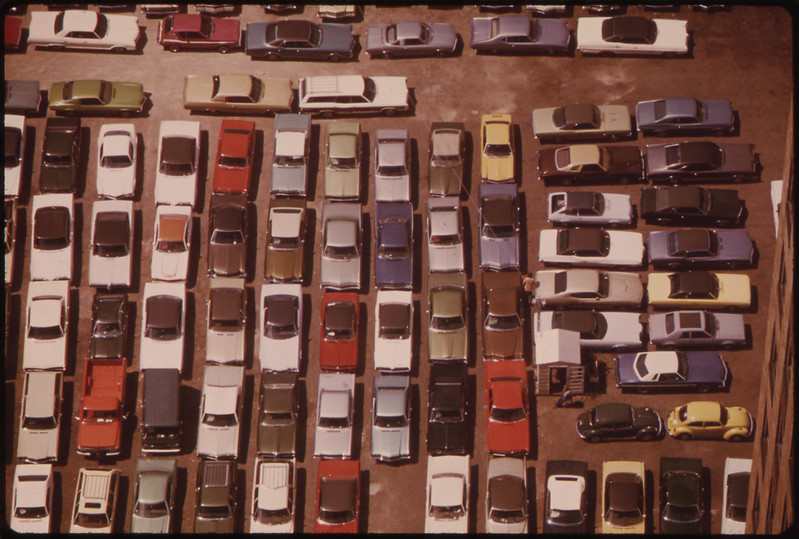
Americans love cars. More than 90% of households own one, more than 20% of households own 3 or more. Cars stand still most of the time and for that, we need huge amounts of parking.

picture of parked cars

Image source: Flickr Commons

The simplest way to map a parking area in OSM is to draw an area and mark it amenity=parking. It will then show up on the map as a grey area with a blue “P”. In the United States, almost a million areas exist with the amenity=parking tag.

See full entry

Location: East Liberty Park, Salt Lake City, Salt Lake County, Utah, 84105, United States
Posted by Vina Kita on 7 November 2022 in English.

Are You Alive ?

I’m looking for an oasis in the desert

but i can’t find

All I found was a dusty stretch of sand

who seems to laugh at my despair

I’m feeling dehydrated now

throat tightening

as if I can no longer walk this leg

stepping on the dusty grains of sand

can’t feel anymore

I will continue this journey

I’m tired and tired

I can no longer endure

in this barren and arid field

I can no longer endure

in this absence

in this helplessness

I hope that a traveler will come

bring a drop of water that will cool this soul

a soul that hurts because of love

Location: Cikole, West Bandung, West Java, Java, 40931, Indonesia
Posted by Graptemys on 7 November 2022 in English. Last updated on 16 November 2022.

I often use apps using OSM data to find nearby restaurants to go to. However I noticed that most restaurants in my area do not have cuisine information, and many that do have typos or other non-standard values that can’t be processed by the apps I use. This makes it harder to find a place to eat. So I cleaned up all the cuisines in my country to improve the usability of the data that is already there.

Using JOSM I was able to do this at scale. I would do it for more places but it requires some knowledge of local cuisines. I left instructions at the bottom of this post so you can do it for your area if you like.

Process

First I researched all the existing uses (mostly using taginfo) and updated the Key:cuisine wiki to reflect current usage. With a clearer picture of what tags are in use and which are duplicates, I felt confident in sorting through thousands of tags and determining which ones had issues that needed to be fixed.

JOSM allows me to easily download and filter objects. The Tag Editor plugin allows me to easily edit a large list of objects. With these tools I was able to focus on making edits and not on repetitive tasks or on sorting through objects I don’t need to see. The exact steps and filters I used are below.

I want to be clear that I’m specifically trying to avoid making decisions about which tags should or should not be used, and I’m not making any decisions about what cuisines a restaurant serves. I’m merely matching the original mapper’s intent with current tagging standards. Mostly this means fixing typos and syntax, and occasionally moving the information to a different tag.

Examples

See full entry

Hallo ich hatte seit November 2019 in meinem Landkreis alle Orte systematisch überprüft und fehlende Gebäude, Straßen, … ergänzt. Die Daten wurden mit den Karten des Landesvermessungsamtes überprüft. Im Mai 2020 war der nördliche WAK komplett abgearbeitet. Da inzwischen eine überschaubare Zahl von Neubauten zur Ergänzung ansteht, habe ich geplant, das in den nächsten Tagen zu bewältigen. Und musste feststellen, das nette Zeitgenossen das Projekt sabotieren. - Beim Hauptort Behringen der Gemeinde 99820 Hörselberg-Hainich sind fast alle Hausdaten gelöscht worden. In verschiedenen Straßen von Eisenach zum Bsp. Okenstraße, Friedrich-Ebert-Straße ebenso. Wie kann man das rückgängig machen,

Location: Großenbehringen, Hörselberg-Hainich, Wartburgkreis, Thüringen, 99820, Deutschland
Posted by ZoLuSs on 5 November 2022 in French (Français). Last updated on 6 November 2022.

Intro

En navigant les données de la Sibra dans les différentes cartes (Apple Plan, Google Maps, OSM…), je me suis rendu compte qu’il y avait pleins d’informations qui n’était pas à jour ou alors pas unifier sur chaque platform.

J’ai donc commencer à modifier les arrêts de bus sur OSM puis j’ai trouver les données GTFS de la Sibra sur transport.data.gouv.fr mais il y a pleins de chose qui ne vont pas dans le fichier stops.txt: stop_id incohérent, arrêt dédoublé, lat/lon incorrecte, manque d’info… Et ce genre de problème sont dans tous les fichiers. J’ai donc décider de créer un repo GitHub Sibra-GTFS dans lequel je met toutes les données de manière uniforme et à jour au fur et à mesure que je fait les modifications sur OSM.

L’objectif final est de refaire tout le réseau Sibra (ouf…) sur OSM ainsi qu’au format GTFS.

Mise à jour OSM

Pour être sûr que les données soient cohérentes sur l’ensemble du réseau Sibra, j’ai mis en place une nomenclature des différents éléments du réseau:

Emplacement ou s’arrête le bus

Un point sur une route qui désigne l’emplacement d’arrêt du bus. Les attributs suivant le désigne (exemple Meythet Centre):

  • bus=yes
  • highway=bus_stop
  • public_transport=stop_position
  • ref=MTC1
  • name=Meythet Centre
  • network=Sibra
  • network:wikidata=Q3488417

Arrêt de bus / Platform

Généralement une ligne qui désigne la zone d’attente (sur le trottoir) des voyageurs. Il y en à un de chaque côté de la route. Les attributs suivant le désigne (exemple Meythet Centre):

  • bus=yes
  • highway=bus_stop
  • name=Meythet Centre
  • network=Sibra
  • network:wikidata=Q3488417
  • public_transport=platform
  • ref=MTC1

Des attributs supplémentaires peuvent être ajouter:

  • tactile_paving=yes
  • wheelchair=yes

Abri de transport en commun

Surface de l’abri d’un arrêt de bus. Les attributs suivant le désigne (exemple Meythet Centre):

  • amenity=shelter
  • building=yes
  • name=Meythet Centre
  • shelter_type=public_transport

See full entry

Posted by jidanni on 5 November 2022 in English. Last updated on 26 November 2022.

I made this “brilliant essay” about the US/Canada flag positions on Rainbow Bridge, Niagara Falls.

What does it have to do with OpenStreetMaps?

Well it turns out OpenStreetMaps’ version of the US/Canada boundary is different than that of the International Boundary Commission’s.

Sure hope somebody here will fix it one day, updating OpenStreetMaps’ version with that of the Commission’s.

It’s a series of “turning points” in a river. Sorry about Ground Truth. You’ll just have to trust them.

But if you can’t trust them, who can you trust?

Location: Chippawa, Niagara Falls, Niagara Region, Golden Horseshoe, Ontario, L2G 6A8, Canada

Magic Earth möchte dass man im Kreisverkehr Richtung Wien GERADEAUS fährt. Übersichtlicher wäre HALTEN SIE SICH LINKS oder FAHREN SIE AUF DIE LINKE SPUR oder dergleichen. Fährt man geradeaus kommt man, wer die Strecke nicht kennt, eventuell auf die Autobahn Richtung Salzburg

Location: Hinterbuch, Unterkriech, Regau, Bezirk Vöcklabruck, Oberösterreich, 4844, Österreich

Magic Earth sagt man soll von der Jedleseerstrasse HALBRECHTS abbiegen um auf die Floridsdorfer Hauptstrasse und in weiterer Folge auf die A22 zu gelangen. Die Ansage sollte meiner Meinung nach heissen BIEGEN SIE RECHTS AB. Biegt man halbrechts ab fährt mancher Richtung AN DER OBEREN ALTEN DONAU

Location: Katastralgemeinde Floridsdorf, Floridsdorf, Wien, Österreich
Posted by WARUMICHRADFAHRE on 3 November 2022 in English.

After a slight nudge from another user, I changed the attributes of the ghost bikes I had entered the day before. And also the attributes of the ghost bike on the outskirts of Pulheim on the border with Cologne. Also, I uploaded a track through Ehrenfeld yesterday.

osm.org/user/warumichRadfahre/traces/5262583

Übersetzt mit DeepL https://www.deepl.com/app/?utm_source=android&utm_medium=app&utm_campaign=share-translation

Posted by pfg21 on 2 November 2022 in Russian (Русский). Last updated on 14 February 2023.

после отправки java8 по речке стикс, вместе с ней уплыл и JavaWebStart, через который у меня долгое время автоматически обновлялся josm.
немного поковырялся с OpenWebStart - он у меня просто не пошел.

после чего нашел элементарное решение в виде опции классического wget.

-N –timestamping Turn on time-stamping.

опция допускает скачивание файла только в случае если время файла на удаленном сервере больше чем время локального файла. что нам и нужно.
еще требуется чтобы файл лежал в текущей рабочей директории.

получился простенький скрипт, который работает много-много лет еще со времен виндовс хп.
josm_start.bat


:: переходим в директорию где содержится файл джосма.
cd С:\path\to\josm

:: проверяем на обновления и перекачиваем джосм если нужно
wget -N https://josm.openstreetmap.de/josm-tested.jar
:: есть еще https://josm.openstreetmap.de/josm-latest.jar
:: Development version, посвежее и вероятно побагованнее

:: запускаем через Hidden Start чтобы не зависало консольное окошко
:: у вас эта строчка будет другая
C:\path\to\HiddenStart\hstart64.exe /NOCONSOLE “C:\Program Files\Java\jdk-17\bin\java.exe -Xms1024M -jar C:\path\to\josm\josm-tested.jar”


всё, теперь джосм проверяется на обновления каждый запуск.
ярлык на скрипт можно положить куда угодно.

недавно спрашивали, вот таки добрался написать.

Posted by alexkemp on 2 November 2022 in English. Last updated on 4 December 2022.

26 November 2022
The last page in this sequence of diary entries used to be “1800 to current”. It became so large as to become unreasonable, so I have broken it up into two pages: the original first half is now “1800 to 1899” (this page), whilst the second is now 1900 to current.

Details:– 1800 to 1899

  • 1800 July 2: Twin Acts of Union are enacted by the Parliaments of Great Britain and of Ireland to create the United Kingdom of Great Britain and Ireland (this was all of Ireland; previously the union was a Personal Union due to having the same monarch — see 1541). These Acts came into force on 1 January 1801, and the 1ˢᵗ joint Parliament was on 22 January 1801.
     
    This was the moment when the modern UK Flag came into being (used as a “Union Jack” on UK ships). It is the 1707 Great Britain flag united with the red saltire of Ireland. Interestingly, the GB flag is symmetrical, whilst the UK flag is not (meaning that it should NOT be hung upside-down nor reversed).

See full entry

Location: Hockley, St Ann's, Nottingham, East Midlands, England, NG1 1LG, United Kingdom