Users' Diaries

Recent diary entries

Posted by kuopassa on 26 October 2022 in English.

Not only “the mole people” live underground, as there are large urban areas, publicly accessible, built below the ground level, and indoors in general.

As an example of an indoor world: Easton Helsinki, in Finland, which has about 4.8 million visitors per annum. (Source.) It’s built on multiple levels. OpenStreetMap doesn’t yet have support for such multi-levelled maps, but it could: a level is just a layer.

Mostly underground is the bus terminal at Kamppi, in Helsinki. It has elevators and escalators carrying countless people up and down, in and out of tunnels and halls. Most of this world underground isn’t yet seen in OpenStreetMap.

Posted by WilleGIS on 25 October 2022 in English.

TL:DR River Polygons with river lines good, river lines alone bad.

Water Body digitization is the base line of water networks on openstreetmap. Every point, line, and polygon has been either manually created or generated through a computer application. Much like roads, rivers and other water bodies can be and sometimes are crucial resource for transporting goods.

Historically, cities and small towns were generally near a water body for drinking/bathing water, cargo transportation, and in the past one hundred and fifty years rivers are used for electric power generation.

Water Body Polygons are used in all types of maps so why not make these features correct by providing a more detailed polygon over just providing a line.

EX. The Sprague River in Klamath County Oregon is a perfect example of having many twists, turns, islands, and variable width across it’s path. Detailing these features in larger scales may not be as necessary as smaller scales below 1:150,000.

Location: Klamath County, Oregon, United States

Добавлено и/или отредактировано 109 объектов, в районе пос. Исеть, пос. Северка (Свердл обл). Нарисовано несколько лесных дорожек, бродов, охот вышек и охот полей. Кольцо получилось без малого 100 км. Двигались по заранее запланированному маршруту, и каждый раз боролся с желанием повернуть на отсутствующую на карте дорожку, коих было прилично в том районе)

Location: муниципальный округ Первоуральск, Свердловская область, Уральский федеральный округ, Россия
Posted by Peter Elderson on 24 October 2022 in Dutch (Nederlands). Last updated on 3 March 2023.

I tried using a GoPro Hero on foot to assist in mapping foot routes, with mixed results. For foot route recording, you need to keep the “blind circle” as small as possible, because you want to record the surface, kerbs and the usually small poles carrying the signs. If you mount the camera say on a stick in a backpack, the forward view always is largely your own head. Second requirement: you want to capture the usually small signs, often with even smaller lettering, and the text under regular signs, which give hikers details about access and rules, e.g. dog access and breeding season closure.

See full entry

Posted by adreamy on 23 October 2022 in Korean (한국어). Last updated on 25 October 2022.

특히 차길 갈림길에서 진행방향을 잘 표시해 주는 것은 지도의 쓰임새를 좋게 하는 데에 무척 중요합니다.(나중에 그림을 덧붙이겠습니다.)

진행방향에 따른 차선이 나뉘어 있지 않고 하나로 그려진 경우, 특히 골목길이 큰 길과 만나는 경우에는 가끔 우합류는 허용이 되지만, 좌합류는 (중앙차선에 막혀)허용이 되지 않는 경우가 있습니다. 또 갈림길 대기선에서 유턴이 허용되지 않는 경우도 가끔 있고요… 이런 것들이 표시가 되지 않으면 길찾기를 했을 때 아주 엉뚱한 경로를 알려주게 됩니다. (브라우저 안 편집기(iD)에서는 이게 참 쉬운데, JOSM에서는 제가 방법을 터득하지 못한 건지 꽤 어렵고 복잡하네요. 쉽게 할 수 있는 수를 아시는 분이 계시면 좀 알려주시면 고맙겠습니다.) 갈림길의 점을 누르면 진행방향 표시를 할 수가 있는데, 여기서 진행을 해도 되는 방향을 정해 주면 됩니다.

이것은 특히 길찾기 같은 걸 할 때 정확한 정보를 줄 수 있어 무척 중요합니다. 많은 분들이 좀더 신경을 써 주시면 아주 쓸모있는 OSM이 될 것이라 생각합니다.

YouthMappers Pre-conference meeting.

On the 18th August YouthMappers called its members to meet. This was a great moment ever for YouthMappers member to meet again for second conference since 2017. This gathering was the combination of the 2020 research fellows, regional ambassadors, YouthMappers technical supporters, director, communication officer and the board members.

The first meeting created a space for YouthMappers members to be updated, knowing one another, interacted, collaborated and above discussed the major impacts in their communities as a collective. In the process of continuity in the building of young people who define their future through community works and actively engaged in identifying problems and offering solutions, YouthMappers awarded certificates of appreciation to all its young people. This was a great motivation to Youths who tirelessly and selflessly contribute to open sources.

Highlights:

In 2022 during the conference YouthMappers @[youthmappers.org] launched the first ever documentary in history, highlighting the major impact and voices of young people inclusively. Additionally, in recognizing the efforts of young people across the #67 countries with #327 YouthMappers chapters, young people combined their voices and released the book around all sustainable development goals. This book is a true reflection of YouthMappers current, Alumni, technical team and board of directors voices. It has showcased some major impacts, works and efforts of the young people in their different communities.

The original of this post is on Discourse https://community.openstreetmap.org/t/what-happens-if-let-others-keep-sponsoring-against-openstreetmap/4343?u=fititnt .


The ad (circa 2017)

Source

https://twitter.com/sp8962/status/838676848301260800

Finances (2020, around 100x difference without need to do any core function)

Location: Historic District, Porto Alegre, Rio Grande do Sul, South Region, Brazil
Posted by amapanda ᚛ᚐᚋᚐᚅᚇᚐ᚜ 🏳️‍⚧️ on 19 October 2022 in English. Last updated on 8 November 2022.
  • Mapping
    • Keep up the regular mapping around the place, and while at SotM
    • I wish people would stop adding new man_made tags. #
  • I posted about my State of the Map 2022, which used up most of my mental OSM energy for August.
  • OSMF Board
    • Some suggestions for SotM 2023 generated some board ⇄ sotm wg emails. (I tried to do the right thing and CC the right people while communicating. This policy was adopted by the Board last year. The board member who claimed the board supported the CM bid didn’t tell the rest of the board of this).
    • Local Chapters
      • At SotM, apparently 2 groups asked a fellow board member about becoming a local chapter for Nigeria & Eritrea.
      • I got their contact details and started reaching out to them to start the process
    • Board Meeting
      • I attended the Aug 2022 Board meeting
        • I did plan to schedule an AB meeting with corp. memb.
      • also attended the Aug 2022 mid month chat, there was discussion about
        • odbl-only imports
        • prep for SotM 2022 (osmf stand, board AMA)
        • whether monthly reports from pers. comm. were needed (probably not)

(sorry if i’m missing some details, I’m trying to finish this)

Previously…

2022 Jan. Feb. Mar. Apr. May June July          
2021 Jan. Feb. Mar. Apr. May June July Aug. Sept. Oct. Nov. Dec.
2020 Jan. Feb. Mar. Apr. May June July Aug. Sept. Oct. Nov. Dec.

Social Media: 🐦 twitter: @lalonde / 🐘 fediverse/mastodon microblog: @amapanda@en.osm.town (rss feed)

Posted by KAWAMALA on 19 October 2022 in English.

This is a plan for the addition of building footprint data for Tanga City, Tanzania. The import is currently going through the Import Guidelines steps, and it should be soon an ongoing crowdsourced task

The goal is to import building footprint data developed by Ardhi University (ARU) in Collaboration with Tanzania Communication Regulatory Authority (TCRA) in 2021, using 2019 satellite images.

Read more at : osm.wiki/Tanga_Building_Footprints_Import

Promoting a data-driven decision making culture in Tanga under living lab initiative, we are complementing the global objective of OSM i.e. to create a free editable geographic database of the world by various mapping activities around the region. The initiative uses local member by building capacity on how to use OSM and contributing to it as well as University Students. These mappings have been putting the missing pieces of the community on the map and addressing challenges they face so far. The usage of GIS data as a tool for community as a decision-making data tool can help in timely action and on-time problem-solving.

This is an Initiative for scaling up the OpenStreetMap Project by addition of buildings footprint data for entire region of Tanga,Datasets was developed by Ardhi University Students (ARU) in Collaboration with Tanzania Communication Regulatory Authority (TCRA) in 2021. Furthermore, There are different community mapping activities as micro-works going on in the region, as the mission of enriching and making freely global spatial data as well as capacity building to the local community on how to use free and open source tools in contributing data to OSM.

En estos días he estado mapeando las ciclovías de C uenca, tomando fotografías y decidiendo la mejor manera en cada caso.

Una de las principales decisiones ha sido si incluir una geometría separada para las ciclovías que son paralelas a las calles o si, por el contrario, mapearlas como tags de la geometría de la calle.

Siguiendo los esquemas recomendados en la wiki de OSM, principalmente la sección de cycle tracks, he decidido no dibujar separada la mayoría de ciclovías, por las siguientes razones:

  • Es difícil alinear la línea de la ciclovía con la línea de la calle
  • Al dibujar la ciclovía separada, hay que tener mucho cuidado con las conexiones a las demás calles y esto no siempre es intuitivo para otros mapeadores
  • Al dibujar la geometría separada, hay problemas con los algoritmos de ruteo (ej: las calles transversales, si son de una vía, no permiten un acceso correcto a las ciclovías)
  • usar una sola geometría facilita el mantenimiento.

Un ejemplo de esto es la ciclovía de la Av. 1 de Mayo que estaba originalmente mapeada con una línea separada y que no conectaba con muchas de las calles transversales

Location: El Sagrario, Cuenca, Azuay, Ecuador

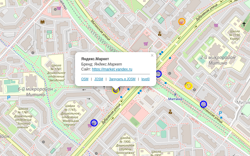
Продолжаю экспериментировать с картами - добавил слой с постаматами.

Разметить можно тегами:

name=Постамат [Бренд]
amenity=parcel_locker
brand=PickPoint
parcel locker:type=cabinet

Из брендов навскидку основные: PickPoint, Ozon, Яндекс, 5post, Почта России. Какие ещё забыл?

скриншот

https://osm.cupivan.ru/postamats/

The current usage of tags in OSM for junctions between motorways is really dangerous in high density areas.

  • There is currently a tag for the junction that is put at the point where the driver can’t change anymore way but at great risk.
  • Author of the current situation say that it’s fine as there is some tags on main lane say there is a junction and mode lane during the split of main road and junction.

I tried it around Paris with Organic Maps in navigation mode. An oral announce is made few hundred meters that driver should at left or right in few hundred meters, then when the change is no more possible, that the change should be made.

In high density areas, junctions can be on the left or on the right, two or three exits can follow from few tens of meters, making it more confusing, especially if there in not any announce of the name or number of the exit (as in case of Organics Maps), and on often overloaded traffic in these areas.

A good solution could be the announce of the exit direction, number or road name/number to follow, that could be verified on traffic signs, this imply that traffic signs nodes contains these informations. In France, on A6, exit numbers are given (ref field), but not the exit direction/name (name field).

Around Ris-Orangis in about 1000m (~40s at 90km/h) there are lot of changes at left/right between A6a, a6b and A10 The current representation doesn’t display at all the parallel lanes, but only start at the last moment the change can be done, from few tens of meters to several km after the start.

The driving rules, say to go as soon as possible on the exit and THEN to slow down quickly, not to slow down on the main lane, nor to wait for last time to change to exit lane.