En veldig god rute som byr på varierende tereng over en strekning på ca 70km litt avhengig av om man ønsker å ta hele runden rundt Tyrifjorden eller korte ned ved å svinge av på Vik over Røyselandet langs østsiden av Tyrifjorden mot Helgelandsmoen, og svinge av og ta broa over Storelva mot Askveien og så mot Hønefoss sentrum. Så nordover mot Hvalsmoen over Randselva opp til Haugsbygd og Klækken ned igjen til Norderhov så mot Hønefoss ca 2 km ,og svinge inn på Trygstadveien opp til Konglefaret. Og denne ruten er på ca 78-80km,og tar i gjennomsnitt ca 3 timer med en snitthastighet på ca 25 km/t. Dette gir en total oppstigning og nedstigning på litt over 1100 meter.
Users' Diaries
Recent diary entries
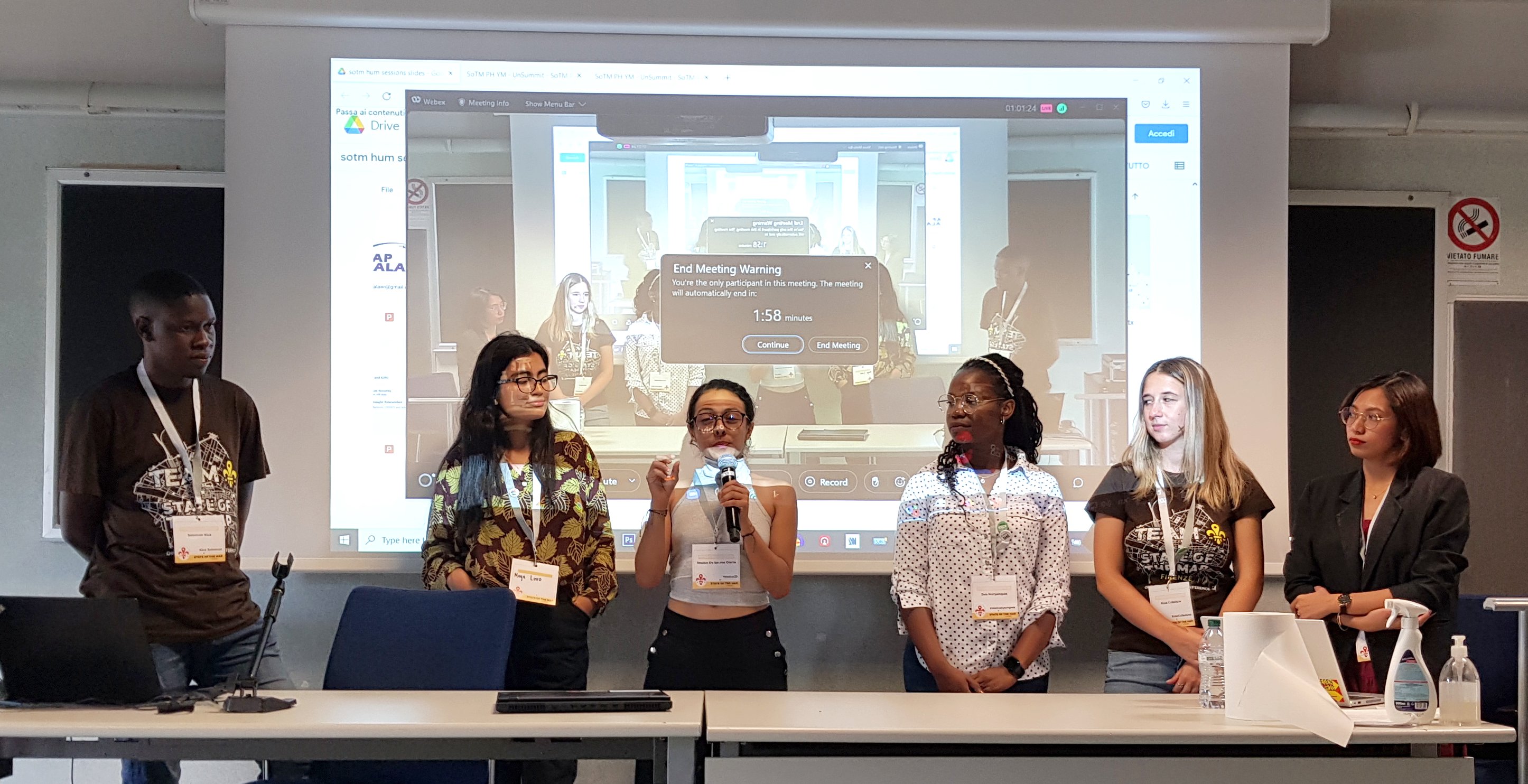
My motivation for attending the conferences was to share the local perspective of open mapping communities and learn from other communities on how they uphold diversity, sustainability, and impact in solving challenges in their communities. I’m grateful to unSummit scholarships for covering all of my travel expenses so that I could participate in this global gathering! - It was worth it.
I was impressed to see and meet the diverse groups represented at the conference, as well as to see that the majority of grantees (both from Unsummit and FOSS4G grants) come from underrepresented communities, which made the conference more interesting - I met and connected with people from different corners of the world… Peru, Fiji, Brazil, Cape Verde, Jamaica, Guinea, Vietnam, and others who have different ideas about open mapping and how they use geodata to solve local community challenges.
SotM was incredible…there are so many applications for OSM data, and they vary greatly from north to south. SotM was also full of community talks and how OSM communities are leveraging data to solve problems in their communities: all of the talks that I attended were excellent, but my favorite was Florian’s talk titled “How to Kill OSM.” (https://2022.stateofthemap.org/sessions/A8JLUY/) - in my opinion, he had great ideas about OSM’s sustainability thinking.
FOSS4G - a more diverse participation, i.e. academia, developers, users, community, business people, and so on: sometimes I would reconsider approaching someone, worried that they would open their computers and run scripts to explain what they do - haha (you should know by now that I am not a technical person, I enjoy working with them though) - but I still enjoyed every minute of the conference with amazing workshops and talks.
On the search for some nice curvy roads. Found some decent ones. SR 424 seems lovely. Next time up I want to go to the Whitefish Ski Resort area before it gets too busy in winter. Not sure if I’ll go there or Ashley Lake next, but it’ll be one of the two. Might knock out both at the same time.
Pour voir l’auteur et le détail des dernières modifications d’un élément, lorsqu’on est connecté en mode modification, il faut sélectionner l’objet puis cliquer sur “Consulter sur openstreetmap.org”, en bas à gauche de la fenêtre (ouvrir dans un nouvel onglet ou une nouvelle fenêtre).
I discovered OSM some time ago… Currently I try to learn every time I can a few things new on it. By trying and trying, for example it is now that I discover the diary section😎
It is both fun and useful since we contribute to a good initiative while having fun.

I thought for quite a few days on the Jochen’s study for the OSM data model, and I’ve no idea on whether it’s good or bad or how to improve it. The process feels pretty straightforward to me.
But that’s the issue. It’s not impossible. To fix OSM data issues, changing the data model is not important. Frankly, I don’t have anything to add to my 2019 talk at Heidelberg. It was a reply to Jochen’s and Andy’s musings on API 0.7 back then, and it is still now.
OSM Africa Monthly Mapathon is an initiative to support OpenStreetMap community development in Africa. The aim is to bring OSM communities across Africa together to learn from each other, network, and grow the spirit of collaboration while contributing data to OpenStreetMap.
Inspired by Gustavo’s diary on his SotM experience, I am putting some of my thoughts down on paper…
This was only my second in-person State of the Map (first in Belgium) but it felt like I’d been many times - people were so welcoming and open, the organisation and volunteers were great and there were a lot of familiar faces (and usernames).
On Friday my main track highlights were Martijn on 10 years of MapRoulette and Kristen on Entry Level Mobile Mapping.
On the Friday afternoon (also World Humanitarian Day), I hosted the HOT unSummit Humanitarian sessions (which you can watch again here) and we heard fantastic stories and insights and saw some great maps, data and tools from 12 different speakers, all relevant to humanitarian open mapping and from all corners of the world. Kudos to the speakers for being so well prepared and to the audience for being so engaged and curious. It was a really great afternoon.

Post d’origine https://blog.openstreetmap.org/2022/06/02/announcement-data-model-study/
Vers un modèle de données amélioré pour OpenStreetMap
Nous connaissons et aimons tous le modèle de données OpenStreetMap avec ses nœuds, ses chemins et ses relations, ainsi que le balisage ouvert qui a permis à OpenStreetMap d’être si innovant. Mais le modèle de données a aussi ses années et certaines améliorations sont possibles. Il y a beaucoup de choses que nous ne voulons pas changer. En particulier, le modèle de balisage ouvert a fait ses preuves. Nous pourrions penser à de petites améliorations, mais l’idée de base, qui consiste à autoriser un nombre illimité de balises clé-valeur (chaîne de caractères), a très bien fonctionné.
Mais il y a quelques points sensibles dus à la façon dont nous organisons nos données. Le plus gros problème est que la localisation géographique n’est disponible que pour les nœuds et non pour les objets géographiques de plus haut niveau comme les chemins et les relations. Cela signifie que pour accéder à l’emplacement d’un chemin, par exemple, il faut toujours suivre les références aux nœuds membres de ce chemin. Cela rend le traitement des données OSM extrêmement lourd et gourmand en ressources. L’autre problème majeur souvent évoqué est l’absence du type de données “zone”. Nous utilisons des solutions de contournement comme les chemins fermés et les relations multipolygones, mais cela a toujours été problématique, car nous ne pouvons pas être sûrs que ces objets sont réellement des polygones valides.
utilsplugin
- must have plugin
- provides several useful tools for faster and more efficient editing in JOSM
- e.g. "Split objects" by pressing "Alt"+"x" as an alternative to the terracer plugin in case of more complex shapes
- more info: https://josm.openstreetmap.de/wiki/Help/Plugin/UtilsPlugin2
Buildings_tool
- must have plugin
- press "b" to activate the plugin
- rectangular buildings can be created with just two mouse clicks if another object is selected as guide for orientation
- if no other object is selected, three mouse clicks are required
- tag "building=yes" is inserted automatically
- pressing "CTRL" deactives auto-snapping. This is required to avoid that the new building has shared nodes with highways
- choosing a node of an existing building as first node offers the possibility to align the new building to the one already existing.
- more information: osm.wiki/JOSM/Plugins/BuildingsTools
HouseNumberTaggingTool
- used to assign house numbers to ways or nodes
- simply select an object and press "k" on the keyboard to open a window with common address keys
- if (downloaded) objects in the vicinity have already assigned keys like "addr:street" or "addr:postcode" these values can be easily selection from a drop-down list. This avoids false edits.
- tool allows to automatically apply increments to house numbers every time a new house number is assigned (increment slider at the bottom of the window)
- more info: https://josm.openstreetmap.de/wiki/Help/Plugin/HouseNumberTaggingTool
Terracer
Toutjava Map
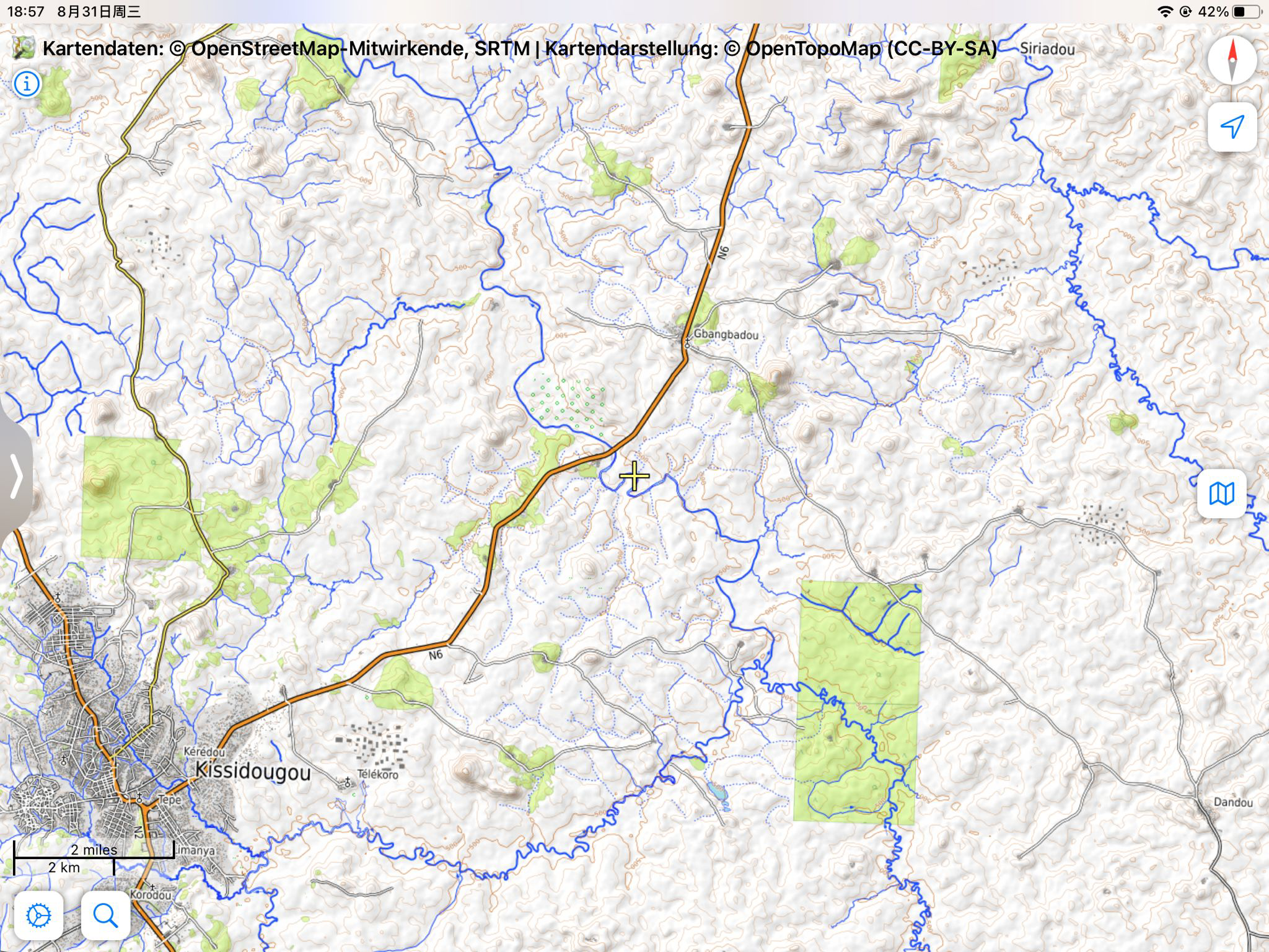
More than 5 mysterious building sites were found in Kissidougou district, Guinea, where the satellite maps show only forest.
These sites were crowded each with more than 30 buildings, each are squares with size about 100x30 m. It is very clear to be seen when we take a look at the OpenTopomap in the north and the east of Kissidougou city, where these buildings are rendered as a lot of big black spots.

The position marked in the article is only one typical example among them: osm.org/#map=15/9.2019/-10.0495
Introduction
Taking open-source street-level imagery is a productive and fulfilling way to make a lasting contribution to OpenStreetMap. Typically, amateur street-level imagery uploaded to platforms such as Mapillary and Kartaview consists mainly of images scraped from dashcam footage, or from a handheld smartphone. To a lesser degree, some 360 imagery is also taken. Whilst these are valuable, many street-level imagery sequences suffer from various drawbacks including poor resolution and spatial accuracy, motion blur and narrow field of view. Generally the imagery compares poorly to proprietary alternatives that cannot be used for OSM. In this post I propose a fairly low-budget option for 360 street level imagery that has led to satisfying results. The results are comparible to roughly 1st-2nd generation Google Streetview (circa 2010) and is far better than TomTom/Bing Streetside imagery in Australia.
In this post, GPS refers to geopositioning in general through GNSS, rather than the US satellite constellation.
This post is written from Australian perspective using Android/Windows, so results may vary.
By “affordable” I mean <$1000 AUD. My total expenditure on this project was $700-800 AUD, so that may be inaccessible to some.
I am likely to update this post in the near future as the project continues. Please check back here regularly if you are interested, and feel free to reach out on OSM or the OSM World Discord server.
Camera selection
On this day, I participated in Unique Mappers OSM Nigeria, a monthly Mapathon. It was so exciting to have everyone joining from different part of Nigeria and beyound. I look forward in few weeks ahead when Etsako east would be completely mapped to provide open map and data for humanitarian use.
Today I participated in Unique Mappers OSM Nigeria monthly Mapathon during which I facilitated the mapathon and providing training to newbies in the beginners room. It was so exciting to have everyone joining from diffrerent parts of Nigeria and beyond ,including Germany and Tanzania. We look look forward in the few weeks ahead Etsako east project would be completely mapped to provide open map data to drive humanitarian response and social good project
Az utóbbi időben észrevettem, hogy egyes helyen az épületek a műholdképek eredeti helyzetétől eltova kerültek felrajzolásra. Fel kellene mérni, hogy melyik eltolás vázolja fel pontosan a valóságot, vagy hogy a valóságban van-e egyáltalán eltolás a műholdképek eredeti helyzetéhez képest. (Lásd: Siklósi vár, várfal.) Azért lenne nagy szükség erre, hogy Siklós ne egy nagy összevisszaság legyen a térképen.
Várom a javaslatokat, hogyan lehetne ezeket teljesíteni. Én a GPX nyomvonalakra gondoltam egyrészt, vagy egy LIDAR-os drónra, amivel fel tudnánk digitalizálni a terepet. LIDAR-os drónom viszont sajnos nincs.
- GPX fájl az eltolódás vizsgálatára: osm.org/user/Guzsv%C3%A1ny%20M%C3%A1t%C3%A9/traces/4849552
Переосмысление пришло после нескольких лет активного участия в маппинге. Я регулярно находил время между работой и семьёй на прогулки по району с целью уточнения данных. Одно дело новую тропинку отрисовать, исправить неточность. Где-то добавить POI, где-то внести время работы, контакты и прочее. С крупными магазинами проблем возникало меньше, так как тот же Перекрёсток если открывается, то открывается надолго и в его работе мало что меняется годами. Самая основная головная боль - поддержка в актуальном виде мини-магазинчиков. Сегодня тут пиво, завтра шаурма, послезавтра восточные сладости. Одно дело, когда всё это у тебя перед глазами, на пути от метро до дома, к примеру. Другое - когда на другом конце микрорайона, где ты бываешь раз в год в лучшем случае. Этот недостаток можно было бы решить привлечением новых маперов в проект, но, к сожалению, в России OSM непопулярен, а количество энтузиастов, готовых за бесплатно тратить несколько часов, а то и дней в неделю своего времени на маппинг стремится к нулю. В этом плане, конечно, респект и уважуха literan !
На фоне всего происходящего в OSM, Яндекс карты просто вне конкуренции, особенно с их подходом к рекламе на карте. Владельцы торговых точек (к примеру) сами их вносят и следят за актуальностью информации.
Так что в OSM есть смысл вносить лишь те POI, которые ни куда не уйдут или же, которые вы часто видите, иначе через несколько лет получите тонну мусора на карте, к сожалению.
Wstęp
Mój pierwszy projekt - szczegółowe zmapowanie obszaru mieszczącego się między ulicą Józefa Chłopickiego, Makowską i Szaserów. Był to też projekt, który nauczył mnie całego OSM’a. Zbyt dużo nie ma co tutaj opisywać, ale postaram się wypisać najważniejsze etapy tworzenia oraz powstawiać gify 😁
Mapowanie
Na początku zaplanowałem, w jaki sposób będę mapował, żeby przelecieć po wszystkim. Trudne to nie było, bo przecież obszar jest mały i podzielony drogami. Zacząłem mapować od lewej do prawej i od dołu do góry, gdzie jeden changeset obejmował “wyspę” otoczoną drogami, których nazwy zawarłem w tytule zestawu zmian. Dodawałem płoty, ogrody, ścieżki, podjazdy, wejścia do domów. Gdy doszedłem do ulicy Lubieszowskiej @syntex zwrócił mi uwagę, że landusy nie są pocięte oraz, że budynki nie są wymienione. Wytłumaczył mi co i jak i musiałem od nowa przelecieć po wszystkim. (No ale tak to jest, że pierwsze edycje są gorsze od nowszych).