Ma az unokatestvéremmel, úgy döntöttünk, hogy elmegyünk biciklizni. A kellemeset a hasznossal keverve, felvittem a házszámokat a Korvin utcában Siklóson, valamint a Gyűdi úton, s a Járó Péter utca jobb oldalán, Máriagyűdön.
Users' Diaries
Recent diary entries
It was wonderful, if slightly overwhelming and sometimes surreal to finally meet so many fellow mappers again at SOTM Firenze last week, as well as so many new friends that I’d only interacted with online. This was my 4th in person event and it reinforced not only how much Crowd2Map has grown since Brussels 2016 but also how the mapping community has changed.
In 2016 arrived in Brussels late at night, a bit disconcerted to find that I was sharing a bed with a stranger - Miriam from GeoChicas. We quickly got over this surprise and she became a great friend and ally, even visiting the FGM Safe Houses we work with in Tanzania en route to FOSS4G 2018. In Brussels I was a newcomer who knew no one. I tried to navigate the seeming chasm between the brown shirted craft mapper gang and the humanitarian team. In Firenze I was very pleased to note much less of this divide. Arriving felt like coming home after a long journey, meeting so many people from previous events and others for the first time IRL.
Particular highlights for me were talking about the impact of our Digital Champion project, meeting colleagues from Missing Maps HOT and Youthmappers who I’d only interacted with online. Kristen Tonga’s talk on the challenges of mobile mapping in rural Tanzania really resonated with our experiences setting up our Digital Champions program, and we look forwards to working with her going forwards.
Ilya is always enthusiastically working on something interesting and this year was no exception, we’re looking forwards to working with him on Every Door soon. The We’re also looking forward
We were particular proud that Binyam Dele Youthmapper Ambassador from Ethiopia wants to replicate our work fighting FGM there.
Greatly looking forward to next meet up - particularly State of the Map Tanzania in January 2023 and hope to see many of the mapping community there either in person or online!
The following is an incomplete list of 360 camera sequence examples by model on Mapillary, along with some comments, with respect to the image quality and price of the camera. This will be an ongoing work in progress.
| Camera | Example | Comments |
|---|---|---|
| GoPro Fusion | Radiotrefoil | Image clarity much worse near stitch line between hemispheres but overall quite good |
| GoPro Max | 360ms; ademturkmen | Very similar performance to Fusion |
| NCTECH LTD iSTAR Pulsar | zaf3kala | Professional quality 11K spherical images, price unknown but assumed to be very high |
| LG Electronics LG-R105 | yoelt | Cheap option, offers OK results but a lot of text illegibile |
| HUAWEI VOG-L29 | lehestener | Invalid spherical image? |
| Insta360 One X2 | jkingsleya | Image quality doesn’t justify price of camera |
| Ricoh Theta SC | adam2 | |
| MADV/Xiaomi Madventure | gness | |
| Garmin VIRB 360 | max93600 |
Please feel free to help me add to this list and share your insights using the Google sheets link below. https://docs.google.com/spreadsheets/d/1ajTm_0fRKLHiGJS2TW0CNscbW4NItuyjkJxzU_kbLXg/edit?usp=sharing
The Mapillary GraphQL API can access metadata for camera make/model, however it is an undocumented feature and lately I have been getting “access denied” error even when using my API token. If anyone knows a workaround please comment.
Some times I feel like I’m the only person who really gets me. I don’t have friends, but a mother that is our of this world. I want to explore this
I was preparing a video tutorial about stiles (online tomorrow morning on my channel). Even though I have mapped quite a few stiles while hiking, I came to the realization that I had mapped a lot of them wrong (mostly using OSMAnd, where I have to remember a lot of tags, bc they’re not presets) after reading the wiki page barrier=stile. Oops. While reading the page, it occurred to me that it was a bit messy, so I tried to tidy it up a bit and tried to find some examples for such cases that are a bit tricky to decide, like the stepover. I had tagged some of those as ladder, because they included more than one step.
I also took a look at the taginfo for the stile values, and boy, was there chaos! I mean, we’re mostly all humans, so we make mistakes and typos which might then be propagated through auto-text in JOSM or copying and pasting, who knows. I actually found one mistake I made myself this way. Some were obvious typos (steover) that I could correct without having visited the site, for others, I contacted the person who had added them (sometimes as far back as 8 years ago, so they couldn’t remember, and just had to delete the stile=* line, unfortunately).
But I also looked at commonly used ones like hipster and added explanations to the wiki page. Two I had to translate into English, and I hope I did it correctly, because they were both in languages I don’t speak, so I used image search to figure out what could be meant. I reduced the list from 4 pages of values to 2.5, so it’s a bit tidier now.
跟一下西园寺铃老师的风)
——————
>工程进度查询<
预处理阶段 线路代码与相关信息替换,添加车站TMIS
按照GB T 25344-2010执行
第一阶段 局直站、主要编组站、各机车、车辆、工务相关单位
哈尔滨 齐齐哈尔 牡丹江 佳木斯 三间房 哈尔滨南 东佳木斯 昂昂溪 富拉尔基 等
哈尔滨机务段 三棵树机务段 齐齐哈尔机务段 牡丹江机务段 佳木斯机务段及下属车间;
三棵树车辆段 齐齐哈尔北车辆段 齐齐哈尔车辆段 齐齐哈尔车辆厂及下属车间;
哈尔滨大机段 牡丹江救援车间及下属基地;
第二阶段 各线路的分界站交汇站、枢纽站旁以信号所或线路所形式设立的车站
绥化 南岔 莲江口 东门 香坊 孙家 王岗 万乐 朝中 加格达奇 林口 勃利 等
第三阶段 局界口、国界口、换轨站
兰棱-蔡家沟 五常-杜家 立志-太阳升 泰来-街基 斗沟子-鹿道 阿尔山北-伊尔炧-阿尔山 绥芬河 满洲里 同江北
第四阶段 各线沿线车站线路整修、分析线路拨改废弃痕迹、增加道岔股道编号、校准正线站线分布与里程数据
已于2023-06-27完成基本工作。
第五阶段 线路打包、建立关系
该步骤正在北京局试点,本工程已作前期预留,待体系成熟后将会同步。
I’m sure some of you have heard of a map that shows the locations of AEDs in Poland, available at https://aed.openstreetmap.org.pl. Thanks to community activism and a campaign among local government units, more than 3,000 device locations have been introduced. Encouraged by the success of the Polish map, we were then tempted to expand the project’s area of operation to increase community involvement in inputting AED device data into the OpenStreetMap database.
Currently, two members of the OSMP organisation tomczk and starsep are attempting to rewrite the existing version of the website using React technology and implement new functionalities. Their results to date are now available at https://openaedmap.org.
The website will be continuously developing. We would like to prepare websites with statistics broken down by country and make it possible to download data in the same way as in the Polish version of the website. The Colleagues are also working on improving and extending the form to allow not only the addition of device data from the page, but also editing.
Our dream is to expand the functionality with the ability to add photos of devices in order to verify them and make it easier to find them in the field. For which we do not have the technical resources at the moment, but hopefully we can acquire a technology partner to help us with this.
Unfortunately, due to the amount of work this project requires, we need Your help. If you have skills in the following areas please email us at: aed@openstreetmap.pl
We need volunteers to support us with their React.js (front-end) and Python scripting skills, and because of the international character of the project we also need help with translations into languages other than English, with priority for French, Ukrainian, German and Spanish.
The Polish version of this entry is available at: OSMP page
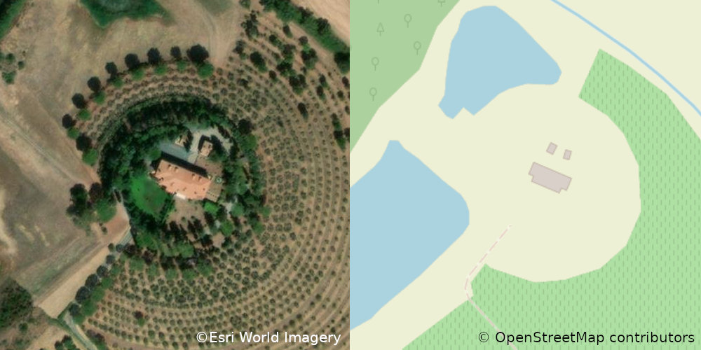
It’s not vandalism, but just a funny case of Pareidolia.
The location is near Castiglione della Pescaia, Tuscany, Italy.
At long last, I’ve done a complete pass over municipal and CDP
boundaries in New York State. Barring errors and omissions (I
daresay there must be some) every incorporated community and every
CDP in the state has had its border checked against NYSGIS
Civil Division Boundaries and TIGER/Line 2021 respectively, almost
always resolving conflicts in favour of the former.
All have place=* nodes representing them, with the node a label
member of the boundary relation.
Populations are updated as of the 2020 Census. GNIS, FIPS, NYS SWIS, Wikipedia and Wikidata links are provided.
Most of the remaining work that I’d have to do before I consider
the job to be done has to do with the tagging on the place=* nodes.
Right now, they’re a hodgepodge. Most of them came in from the TIGER
import of 2008 with place=* representing their form of government.
This is NOT an indication of the significance of the place.
Brentwood, Long Island, a bustling community of over 60,000 souls,
is tagged place=hamlet because it does not have home rule.
Geneva, a sleepy lakefront village is 3400 inhabitants or so,
is tagged place=city because it has a city charter.
For a first stratification, I’d propose simple thresholding on population:
Ma hazafelé tartva felvittem StreetComplete-ből pár házszámot a Felszabadulás utcában. Utána, a Harkányi úton felvittem az épületek magasságát.
46.8220444,-71.2470919
For the rest of the year I will be working on railways. I will use references from various sources to verify my work.
Start AUG 20 2022
End DEC 31 2022
Sponsored By: None this time.
Lights
First encounters
After mapping street lights and poles and then Seamark lights I looked deeper into how to map light mostly light that is made my man and is in a consistent location. The addition of mapping lighting in Street Complete made this question greater with a tag like lit=yes this is great and all but not very descriptive if talking about a street or a way that may have puddles of lights at each street light.
Beyond
This has taken me to the point of looking at adding night lighting to the tops of power poles or rotating beacons on top of airport towers. These sorts of things could be found it mapping seamarks but for the most part is not appropriate for Open Sea Map. This is the line between it exists and there is a standard to make the light show and to add the correct tags to describe its sequence of flashing but it is not a seamark light but there is overlap between. There are power pole or tower lights that do show on nautical charts.
Thoughts and reflection
Are we mapping with enough detail, is it easy for a first time mapper to contribute, and are we mapping for the renderer? Anything I missed below?
Lit:
Highway:
osm.wiki/Key:flashing_lights osm.wiki/Tag:highway%3Dtraffic_signals osm.wiki/Key:crossing osm.wiki/Tag:highway%3Dstreet_lamp
Railway:
osm.wiki/Tag:railway%3Dlevel_crossing osm.wiki/Tag:railway%3Dsignal
Man_made:
osm.wiki/Tag:man_made%3Dlighthouse
Seamark: osm.wiki/Seamarks/Lights osm.wiki/Seamarks/INT-1_Section_P
Complicated Light mapping. osm.wiki/Seamarks/Sectored_and_Directional_Lights
Aviation: osm.wiki/Proposed_features/Aviation_Obstacle_Light
I have been tracking down some properties owned and managed by the University of Michigan, Michigan State University and Michigan Technological Univeristy. These include university properties managed as farms, forests, nature reserves, and field-based teaching. Many are open to the public, so this allows greater access to recreational opportunities by having these added and available in OSM.
Other efforts have been to map properties owned by the Nature Conservancy and other land trusts that are open to the public. County Forests, parks, and other local owned public properties are important in my view as well. The MapRoulette challenge for Michigan GNIS nodes by user BBMiller has been a useful tool to focus on those features, particularly the emphasis on adding the GNIS:feature_id identifier which will assist with Wikidata and Wikipedia integration.
I was inspired to create my own MapRoulette Challenge for Michigan GNIS stream and canal points to add the GNIS identifer where missing, as well as build in potential for future automated editingn tools to improve connectivity to wikidata, and just plain add in named rivers, streams, and drains that are missing from OSM, incomplete, or need their ways to be collected into relations.
Upcoming, i am thinking of making another MapRoulette challenge for the midpoints of roads on the Ottawa National Forest- most of those seem to be missing so that would be an opportunity to focus on digitizing and adding those in a high quality level from USGS 3DEP/aerial imagery rather than directly importing.
Just been a lot of fun working on Michigan things and figuring out some routes to improve OSM. See you in the changesets!
It has been the 435 days since the start of my OSM days, don’t remember why I started, I just did. It started small with adding minor businesses and fixing road names, then I mapped out large chunks of landuse at a time around my hometown. eventually, this evolved into an ongoing (though slowly moving) project across the Central-Eastern part of Connecticut. Then recently I got involved with the OSM Discord server for guidance. Also recently I began #NoteFreeCT like #CloseTheNotes but we (I) focus on Connecticut as a whole, also started a little micro mapping as well, hopefully all this doesn’t get too out of control.
Until next time, Jmapper007
P.S. next time most likely won’t be any time soon.
.
..
The Problem
In order to do beautiful micro-mapping it is necessary to map ways with a lot of nodes. However, it is painful for other mappers to connect their own adjacent ways to these nodes.
Possible Solutions
-
Some mappers have suggested using multi-polygons to cut those ways and attach multi-polygons. But I have a personal problem with this which stems from the fact that a lot of beginners have a hard time understanding the concept of multi-polygons and how to use them.
-
Another solution is to remove the way entirely. However, this also removes the history of that item, which I’m averse to.
The Main Culprit
The #ADT Apple Data Team has been multiplying nodes on coastlines and waterways all over Central America. Here are some examples:
Changeset in Belize by DaleOfAire
The State of the Map 2022 (SotM) international conference will start in a few days. It will be the first in-person conference after the Covid19 pandemic started and thanks to the SotM volunteers, it will be a hybrid event.
While participating in SotM can be exciting for community members, it can also be stressful for introverts or people who plan to attend but want to minimise their social interactions due to Covid. Additionally, there are people who would like to approach others to talk to them, but may feel apprehensive doing so.
Trying to help with the above, this year I will bring some coloured communication pin-back buttons that community members can get and wear during the conference. The aim is to facilitate participants’ communication by making it easier to show if you want other people to talk to you at a given time or not.
What coloured communication pin-back buttons you can get at State of the Map 2022
The idea is that participants can wear a different button based on their communication preferences at the time. Showing a
- green pin-back button: the person is actively seeking communication and wants to be approached by people interested in talking.
- yellow pin-back button: the person wants to be approached by people they had discussions before. The person may approach other people to talk (if they wear an appropriate button or none at all), and that is ok.
- red pin-back button: the person probably does not want to talk to anyone or just to selected people. The person may approach other people to talk (if they wear an appropriate button or none at all), and that is ok.
If someone talks to you even if your button indicates that they shouldn’t, please keep in mind that they might not know about these buttons.

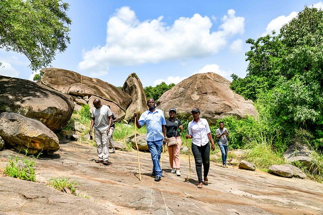
Baker’s Fort Patiko- Gulu District,Uganda