 OpenStreetMap

I’m home., And I scary , on the Russian war my home Ukraine ((
Users' Diaries
Recent diary entries

Live Validation:
Live Validation involves real time data cleaning conducted during a mapathon. It aims to give feedback to mappers as soon as possible after they mark a task in the Tasking Manager as mapped.
How Live Validation is done:
1.A validator joins a mapathon (either remote or in-person) accompanying the mapathon trainer. Ideally the validator gets a chance to introduce themselves near the start of the session and explain their role.
2.Once mapping has started, the validator uses Tasking Manager to focus on most recently mapped tasks: Within a project in the Tasking Manager under the ‘Tasks’ section select tasks that are ready for validation and sort by ‘most recent’. Carry out validation using JOSM and give feedback in the Tasking Manager.
3.After main training elements are covered - validator gives verbal feedback while screen sharing during the mapathon. It tends to be more polite not to mention mapper names - participants typically recognize the task they have been working on when you share your screen.
Advantages:
1.Capture data quality issues very early to prevent further occurrences by giving mapper feedback to improve.
2.Live validation helps the trainer to identify recurring issues where the mappers might need more guidance during the mapathon. The trainer can then adapt quickly and focus their training on those issues.
3.Live validation gives the validator the chance to give verbal feedback while also sharing those issues visually on their screen - this is an impactful way to give feedback, particularly compared to the typical method which only involves text-based feedback.
4.A validator gets the chance to demonstrate feedback channels (Tasking Manager notifications) with mappers to make them aware of where they can find feedback after a mapathon - this improves communication between the mappers and validators.
Posted by FS (DA14) on 9 March 2022 in German (Deutsch).
Hallo in die Runde,
ich habe Koordinate für die Weg-Achsen mit GPS ermittelt und möchte die Weg-Achsen auf einem Parkplatz anhand der ermittelten Koordinaten anpassen.
Wie macht man so etwas?
LG FS(DA14)
Сегодня я пометил два магазина и назвал одну улицу
Posted by gitclonemafiozy on 9 March 2022 in Russian (Русский).
домов много…
Я забыл что в селе не одна улица и когда я вспомнил об этом я понял что меня хватит только на пометить магазины
Привет Опенсоурс карты!
Однажды я взглянул на карту моего село и ахнул, на карте не было ничего кроме дорог и названия. Но сегодня ситуация лучше так как пользователи отметили стадион, а я хочу пометить дома и магазины!

After just under five months of hard work, I have completed my project of giving every single body of seawater in Canada an area definition. I have experienced some pushback from other editors who had issues with this project, including my practice of only giving one point of seawater a single name, as well as questioned whether area definitions were even necessary and saying that point definitions would have sufficed, as well as how I was defining their extents. However, mapmaking is as much an art as it is a science, and my own preference is for area definitions over point definitions in this case. As well, my “one point, one name” rule had one intent and one positive effect: The intent was to minimize interference with coastline edits, and the positive effect was that I was able to minimize as much as I could the number of ways in each relation, not just for bodies of seawater in a sort of “divide and conquer” strategy, but also for islands as well as for the mainland coastline of Canada. Sure, there were some outliers with thousands of ways, such as the Gulf of St. Lawrence and the Labrador Sea, but there are very few of those, and I would estimate the average number of ways in each relation over this whole dataset is only about a few hundred.
Posted by raphaelmirc on 6 March 2022 in Brazilian Portuguese (Português do Brasil).

A Mapatona na Cidade de XEXEU - (PE) BRASIL foi Concluída com Sucesso, vejam a estatística de mapeamento, 100% Concluído!
The Mapathon in the City of XEXEU - (PE) BRAZIL was Successfully Completed, see the mapping statistic, 100% Completed!
The Mapathon in the City of XEXEU - (PE) BRAZIL
was Successfully Completed, see the mapping statistic, 100% Completed!

Mapatona terminada com sucesso, agora e a hora daValidação!
it can descibe the exact place and location where you come from

今天(3.06)上线发现Maxar Premium Imagery地图已更新。po为太原地区编辑,最近将会更新一些道路和公园。绘图时注意,与去年的数据存在一些偏移,记得纠偏。
没更新二环高速。。。

最近佇咧 OSM dialy 遐有人寫文章,認為 talk-tw 的討論變矣,傷排外用手段阻止編輯。我佇咧想你敢是佮我看仝款的 mailing list,這幾年大都是 weeklyOSM 的出版公告,猶閣有匯入佮大量編輯的通告,確定逐家無問題就動手來做,講實在是無啥物咧討論。
古早時代 talk-tw mailing list 有社群進行串聯熟似彼此,制定臺灣各級行政區的標籤方式,欲社群聚會的時間討論等等重要的議題。後來真濟討論走去較濟人的 Facebook 社團遐,mailing list 就無啥人用。
社群討論不論是佇咧佗位,毋就是欲出聲討論,逐家攏有無仝看法佮做法,提出來嘛會當修正,嘛無看著有其他人的意見 。社群機制親像臺灣原住民區域遐的部落會議,進前亞泥佮在地部落欲諮詢部落敢會當繼續開採礦場,欲開部落會議來投票,過程有好好討論就好,來爭取各方支持。
在地力量在地社群辛辛苦苦咧維護,揣𪜶討論,應該毋是傷過份的代志。進前嘛有外國公司,一个 Snap 想欲模仿 Google 按呢佇 OpenStreetMap 遐存各國認為的「國家」邊界,臺灣予𪜶認為是中國的,所以愛有一个中國認為的臺灣是𪜶的邊界,予社群認為無共識閣爭議傷濟予阻止。採取較激烈的手段是欲為著落尾的討論來起頭,因為好好佇咧編織討論留話,真濟擺是無人回的。
嘛有公司推捒無啥問題的物件,親像 Here 創臺灣的 Maprouttle Challenge 修正臺灣遮的地圖小問題,Apple 嘛有用 Maprouttle Challenge 希望社群有人會當鬥跤手來修正地圖的問題。
我遮有共 Talk-tw 當做愛發文來吸引人來回的目的,社群莫干焦一个所在討論,另外一方面是欲記錄,因為 Facebook 討論濟,毋過無好揣,寄批信到 mailing list 留記錄。
Posted by amapanda ᚛ᚐᚋᚐᚅᚇᚐ᚜ 🏳️⚧️ on 5 March 2022 in English.
Last updated on 6 March 2022.

What I did in OpenStreetMap in January 2022

So currently I’ve been taking some time off from mapping due to the upcoming midterm assignments coming from school, so as the end of the 3rd quarter nears, I do have plans for what I will be doing next.
-
Try to map buildings in areas with worse quality imagery, thus so when I get to better quality areas, progress would beable to be sped up.
-
Map out the urban areas of the Metro East. By doing this It will give more incentive for me to 1. map, and 2. work in those regions more often
-
Finally, I plan on beginning work on Alton hopefully by the end of the month, and if not then definitely before the summer.
…

The New York Times has maps tracking the Russian invasion of Ukraine. I wondered what the data source of the first one was: were they maybe using OSM?
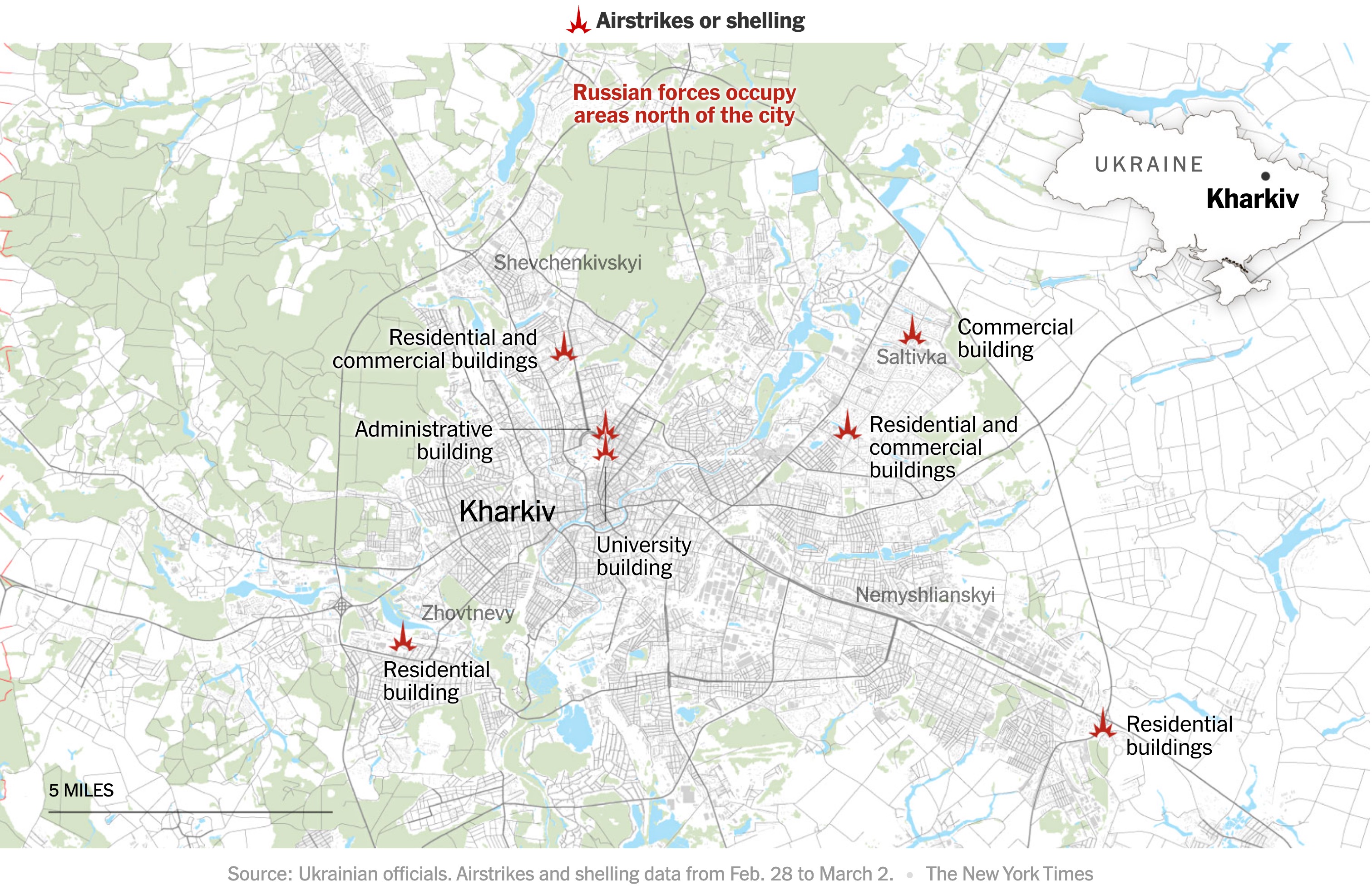
Mappers on the #openstreetmap IRC channel quickly found some differences. Just to be absolutely sure, I used the QuickOSM plugin for QGIS to download OSM data for the area from overpass. I then quickly styled the map, using the colour picker to copy the Times map. In half an hour, I had my own map of Kharkiv.
Posted by mapeadora on 2 March 2022 in Spanish (Español).
Last updated on 3 March 2022.

Recimentar la comunidad OSM LatAm
OSM LatAm como comunidad se consolidó, se puede decir, a raíz de un evento de AbreLatam ConDatos en la Cineteca Nacional de México en 2014, al darnos cuenta que varias personas usuarias y apasionadas de OSM, desde varios países, estábamos presentes, pues nos conocimos y decidimos crear un canal común para reunir a las personas de esta región.
De allí nació el canal de Telegram OSM-Latam, lista de email y Twitter. Telegram en particular se ha vuelto un espacio con participación variable pero intensiva desde entonces, sin necesariamente resultar en actividades conjuntas como región.
A raíz de discutir sobre esta oportunidad nuevamente al final de 2021, el grupo MapTime Bogotá contó cómo sus actividades locales, juntas mensuales y actividades como la resolución organizada de notas, habían logrado consolidar mucho la comunidad en Bogotá, y acordamos su ayuda para impulsar el arranque de algo similar a nivel LatAm. Porque a veces solo falta un empujoncito o una palmada.
Acordamos al menos tener una junta periódica, la primera siendo una parte misma de la junta mensual de MaptimeBogotá. Allí nos conocimos varias personas, tomamos unos acuerdos iniciales como principalmente qué hacer con esta junta, cómo comunicarla y moderarla de manera que facilite la integración de más personas, y construimos una agenda “cumulativa” que se irá tratando poco a poco permitiendo avanzar y también socializar. Estarán documentadas en la ahora página de wiki LatAm
Actividades detonadoras: el Notathón
MaptimeBogotá y Fundación OSM Colombia ya tenían instalada esta actividad, y por lo dicho sirvió bastante para federar las personas alrededor de OSM y hacer grupo, además de mejorar el mapa notablemente, y encontrar un medio de comunicación sana y de integración con mapeadores ocasionales que contribuyen más con notas que con mapeo directo.

UMN Nigeria Carried out online Webinar Training which last 3 times a week on how to use JOSM
JOSM is a free software desktop editing tool for OpenStreetMap geodata created in Java, The editing tool contains advanced features that are not present in OSM’s default online editor, iD. we train UMN Nigeria Members how to Use JOSM Ranging from how to Download it, Map using JOSM on Task Manager, Shortcuts, upload after digitizing, etc
%20by%20Vince%20Emond.jpg)
Well, what a start to the year it’s been! Like mentioned previously, new directions, new collaborations and, I’m excited to announce, new team members!
While you can read the official bios for each new member linked by their name, I would like to take this opportunity to introduce them unofficially to everyone. Please see their unofficial bios and a quick insight into why I’m really glad to have them joining our team.
Leen D’hondt - Senior Product Development Manager
Leen’s unofficial intro
Leen is passionate about maps and how maps are used to create a ‘better’ world. She will co-drive the product strategy of the HOT Tech products so as to build tech products for the use cases our stakeholders care about most.
Leen is not only passionate about mapping and usage of maps. One of the things she loves is to spend time outdoors, especially in the mountains or at the beach. As a mother of two boys, she probably needs to start playing football ;-).
Bo’s intro
Leen is a perfect combination of strategy and action. On her first day, she was immediately asking the big questions of why are we doing this and then jumping straight into what we are doing and how. Pretty much the best first impression a PDM can make.
I am excited to have Leen on board, as she is an open minded active listener, which makes her perfect for this role. Not only does Leen have a wealth of experience in the OSM world (joining us from TomTom), but her commitment to understanding what is best for the team, while at the same time understanding how we serve the ‘greater good’ is something we will all benefit from personally and professionally.
Petya Kangalova - tech_collective facilitator
Petya’s unofficial intro
“I joined the HOT tech team in February 2022 as Tech Collective Facilitator, currently based in Bristol, UK. I am really passionate about the impact of open mapping and using technology as the enabler for people in supporting their communities.
I’m really bored. Sorry if I’m starting a post this way, but a lot of inexperienced people are working in the very crowded are of Mogadishu with the result to get an horrific outcome.
We worked for maybe a couple of months to draw roads, communication towers and buildings (sometimes counting their floors, when the satellite images allow us to do it).
They are (trying to) mapping buildings, for some HOT projects #mogadishu-swm where it’s supposed to be an urban project related to the waste collection. But, inexperienced users, not used to interpretate satellite images nor having some common sense (if you see a large road going straight, why make two 90° bends to put a totally displaced building?), are severely degraded the previous efforts to have a decently accurate map.
I don’t share any picture, but as just a few examples I’ll give you the coordinates.
These are buildings shifted many meters from the existing ones, with the roads deformed: 2.0441091, 45.3154313 2.03717, 45.3523181
Here you can see the masterpiece: 2.0439412, 45.35413 osm.org/go/yAR0QC5~F?m=
Here another very personal interpretation of wrecked buses mapped as buildings 2.0447408, 45.3558223
I was wondering: if someone have (and is still doing) to map buildings, it means someone else are going to use these data. Don’t they realize those contributions are horribles?
I’m not going to waste my time trying to fix that disaster, I’m now busy to fix a lot of landuse relation in DR Congo and Central African Republic damaged or erased by other HOT projects.
Alessandro a.k.a. UNGSC-DTLM-Ale_Zena a.k.a. Ale_Zena_IT

Today was all about Java Open Street Map (JOSM) training, i learnt on how to map tasks with JOSM for the first time and it was lit. I will like to appreciate Miss Chisom Okwuchi, Mr Daniel Kingsley and lastly our National Coordinator Mr Victor Sunday, for this interactive session. i will admit that mapping is fun, mapping is real, non fiction etc…