Users' Diaries

Recent diary entries

In this changeset osm.org/changeset/116307070

a mass deletion of ways was done https://simon04.dev.openstreetmap.org/whodidit/?zoom=12&lat=5.4938&lon=20.84162&layers=BTT&age=1%20month

And instead 9 - I say just 9 (nine) - building were added

Thank you so much https://tasks.hotosm.org/projects/8391 Oh, lately I discovered that the landuse relations affected were more, spanning till to Bambari.

Please #MissingMaps when you’re going to work in a very dense mapped area, write few piece of advice; working in the middle of nowhere or in Bambari province does a lot of difference.

Location: Ouaka, Central African Republic

Ich find die Idee von OpenStreetMap ziemlich gut, eine Art Wikipedia für geografische Karten. Hierher gekommen bin ich einfach, weil ich meine Agentur als Firma in die Karte eintragen wolle. Das hat auch ziemlich einfach und vor allem schnell funktioniert. Zugeben muss man aber, dass optisch das ganze noch ein Stück von GoogleMaps weg ist und definitiv eine App benötigt wird. Ich hätte schon ne Idee, wie das umzusetzen wäre..

Was mir bei Einträgen aufgefallen ist, dass die Zusatzinformationen nicht abrufbar sind, also Öffnungszeiten, Webseite etc. . Falls mir jemand erklären kann wie das geht, wäre ich sehr dankbar. Ich sehe bisher nur eine rote Raute, wo mein Eintrag ist. Vielleicht kann mir das jemand erklären?!

Danke Tom Scharlock pwa.ist

Location: Rabenhold, Arnstadt, Ilm-Kreis, Thüringen, 99310, Deutschland

So I got this message from JOSM:

Error message(untranslated): Placeholder node not found for reference -104469 in way 741879858

Tried various ways to fix the error but it was getting late, so I saved the whole thing as a joz session to tinker with it later.

Next day I tried to load the saved session. No bueno! josm wouldn’t load the data layer because of the error.

Arrgghh.. cue the rage meme. That layer got a complete bus route that I started from beginning to the end, with the accompanying highways chopping, poi adds along the way and all kind of stuff..

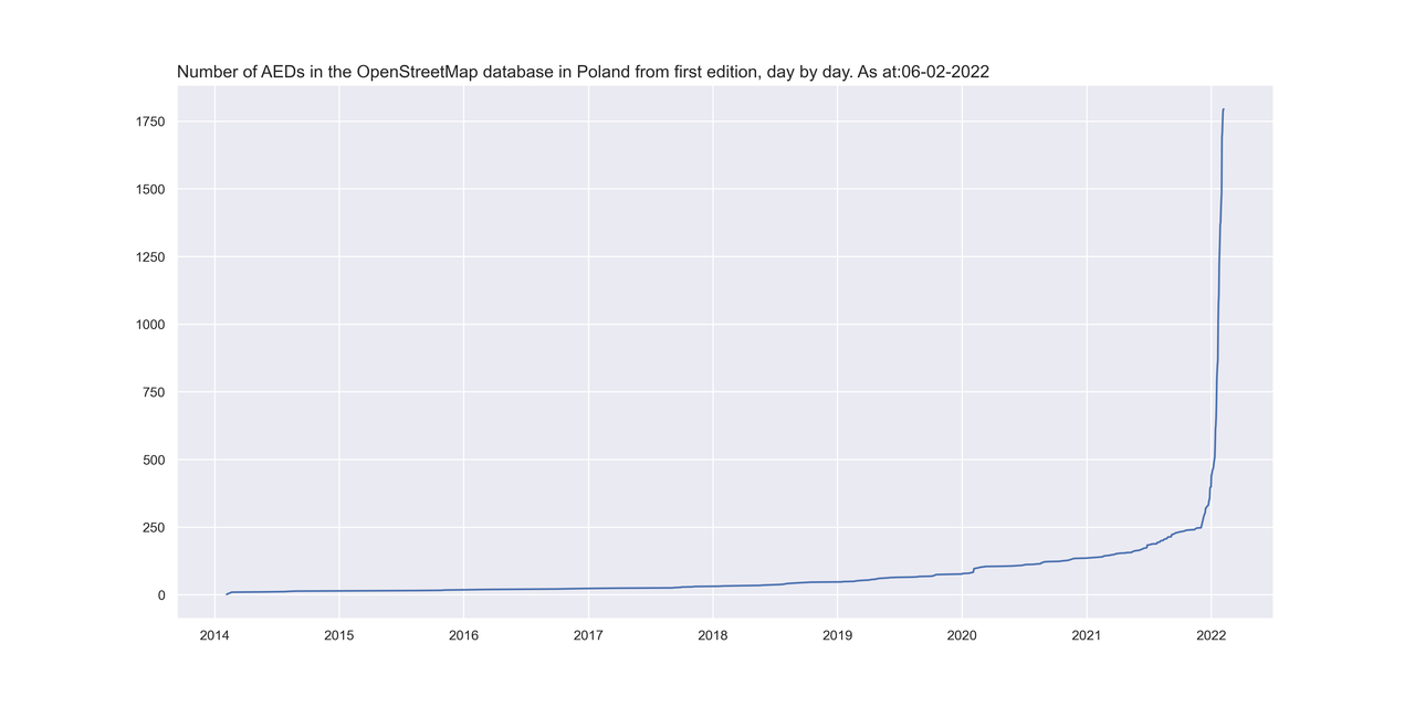
W kolejnym podsumowaniu działań w projekcie AED będzie trochę statystyki. Najpierw dane od początku świata czyli od połowy 2014 roku. Gołym okiem widać kiedy zaczęliśmy naszą akcję z AED.

Wzrost_all

Tutaj mamy dane od początku roku do dzisiaj rana (06.02.2022), Rok rozpoczęliśmy mając w OpenStreetMap 441 urządzeń AED i po ponad miesiącu mamy już 1795 co oznacza, że średnio dziennie dodawaliśmy około 37 urządzeń.

See full entry

Desde o início deste ano, mais ou menos, no mês de Janeiro/2022, venho tentando na medida do possível atualizar dados inerentes à realidade das construções, seja ela de natureza jurídica ou de natureza, digamos que tenha certo vínculo “strictu sensu” por meio de normas à coisas abstratas, ou seja, “sem vida”, como por exemplo, corpos d’água, postes, pontos de ônibus, trem, bicicletário e dentre outros….O além disso, pode ser denotado e especificado no campos e subcampos, como também a sua descrição resumida e notas de observação. *Detalhe: Todo Mapeador/Analista de Geoprocessamento Profissional deve assumir um compromisso sério perante à sociedade contemporânea a sua assinatura ou o seu legado/rastro mais ou menos verídico da situação do território no qual foi concebido, criado, recriado e moldado pelas ações humanas e, inclusive da ações naturais ao longo de centenas e/ou talvez milhares de anos…

Posted by bo_hot on 4 February 2022 in English.

Hi all,

To better get the word out about what hot_tech is up to, each month I’m going to sit down and reflect and share the fruits of our labour so people can see what we’re working on, who’s working on it and how you can get involved. I’m sure these will evolve over time, so consider this a starting point.

Tldr;

  • Welcome to Kristen (android engineer), Leen (senior product manager) and Petya (tech collective facilitator); three new members joining us at hot_tech this month.

  • hot_tech has a new vision ‘just tech to connect people and places’ There’s a lot of ‘new’ this year for hot_tech, including new vision, new direction, new projects.

  • Kathmandu Living Labs are officially our first ever ‘collective’ partners. And will be the new official Tasking Manager maintainers.

You can read the full blog and details on the hot_tech blog here >.

Hope you’ve all had a nice warm up to the new year!

Kindness,

Bo

Location: Naz, Esserts-Salève, Monnetier-Mornex, Saint-Julien-en-Genevois, Upper Savoy, Auvergne-Rhône-Alpes, Metropolitan France, 74560, France
Posted by eternaltyro on 2 February 2022 in English. Last updated on 5 February 2022.

Background and context 🗺️

I’ve been using JOSM to map missing public transport routes in Chennai. It’s a project I’ve been doing for personal reasons which I intend to elaborate in another post and I began with iD only to find later that the order of the route segments matter and iD doesn’t make it easy to do reorder segments.

So I started using JOSM with a helper plugin I found. This has made my workflow much easier and faster. One small annoyance though is that I could only download a small section of a fairly large city to edit the map in JOSM. I discovered I could download larger areas if I carefully picked specific ways or nodes since the limitation (to downloading data) is the total size of data that OSM can return.

So I went and searched the web for examples of OverpassQL and their explanations, learned what I could about how the QL works in the time I had and strung together a quick and dirty query that downloads ONLY roads and bus stops within the bounding-box (that I get to easily draw in JOSM).

This probably could be improved for concision. This is the OverpassQL I use to download roads and existing relations in order for me to map bus routes using JOSM’s overpass-based data import dialogue window.


[out:xml][timeout:90][bbox:{{bbox}}];
(
  wr["highway"="primary"];
  wr["highway"="primary_link"];
  wr["highway"="secondary"];
  wr["highway"="secondary_link"];
  wr["highway"="tertiary"];
  wr["highway"="tertiary_link"];
  wr["highway"="trunk"];
  wr["highway"="trunk_link"];
  node["highway"="bus_stop"];
  node["bus"="yes"];
  node["public_transport"="platform"];
  node["public_transport"="stop_position"];
);
(._;>;);
out meta;

This has some nice conveniences for me:

See full entry

Location: Ward 60, Zone 5 Royapuram, Chennai, Tamil Nadu, 600009, India
Posted by Romeo Ronald on 1 February 2022 in English.

Mapping in a conflict Zone

In a war-torn and post conflict environment like South Sudan, the approach for mapping can be way different, basing on the fact that South Sudan’s war was based on a tribal line, it is again more difficult to perform a more inclusive program like mapping, but as for us at OSM South Sudan looked at this as an opportunity more than a challenge, so we began more basic training with basic tools like the ID editor and concept mapping.

See full entry

Location: Hai Soura, Juba, Central Equatoria, South Sudan

Nach gut 2 Monaten ist der Kartenausschnitt Leipzig Wahren zu 90% durchdetailiert. Einzelne Ortspunkte folgen noch.

Es wurden mehrere Gartenanlagen angelegt und mit Gartennummern versehen. Die Uferbereiche der Flüsse durchgebildet und jede Menge Grundstückseinfriedungen ergänzt. Ebenso wurden die Wohngebiete nach Häuserblock aufgeteilt und neu gezogen (Grenze Bordstein). Beim Campingplatz Wahren wurden die im Wald befindlichen Ferienhütten ergänzt. Diese fehlten komplett.

Ergänzungen die noch fehlen: 1. Auensee (Grünflächen und Bäume) 2. Wohngebäude Pittlerstraße (Fotos fertig - Einarbeitung folgt) 3. Gewerbe Pittlerstraße

Location: Wahren, Nordwest, Leipzig, Sachsen, Deutschland

Uzice is a town in the Zlatibor district, in the Republic of Serbia. According to the 2011 census report, there were 52,646 inhabitants.

It lies on the banks of the river Djetinje. The medieval ruins of the then very important city have been preserved. Uzice was the seat of the Partisan army in the fall of 1941. In 1946, the name was changed to Tito’s Uzice in honor of Josip Broz Tito, and the old name was returned in 1992.

Uzice is a major center of the metal and machinery industry and fruit growing. Administrative center of the municipality of the same name and Zlatibor district.

Just look at the difference, how it looks now & how it did look before the change was made to a map:


View Larger Map

See full entry

W minionym tygodniu udało się pozyskać patronat honorowy dla naszego projektu ze strony czołowych specjalistów medycyny w Polsce. Na liście lekarzy, którzy obdarzyli nas swoim zaufaniem znajdują się:

  • prof. dr hab. Jerzy Robert Ładny - Konsultant Krajowy w dziedzinie medycyny ratunkowej
  • dr n. med Wiktor Kuliczkowski - Konsultant wojewódzki ds. kardiologii (dolnośląskie)
  • prof. dr hab. n. med. Andrzej Wysokiński - Konsultant wojewódzki ds. kardiologii (lubelskie)
  • dr hab. n. med. Łukasz Balwicki - Konsultant wojewódzki ds. zdrowia publicznego (pomorskie)
  • prof. dr hab. n. med. Marianna Janion - Konsultant wojewódzki ds. kardiologii (świętokrzyskie)

Jednocześnie przebudowaliśmy i rozbudowaliśmy stronę projektu. Wyszukiwanie oraz import danych jest teraz ułatwione. Lokalizacje AED są dostępne do pobrania w formacie csv, xls oraz GeoJson bezpośrednio z poziomu strony. Obecnie mamy zlokalizowanych ponad 1500 urządzeń (stan na 30.01.2022) Cały czas spływają do nas dane z samorządów więc ta ilość będzie się jeszcze zwiększać.

W przyszłym tygodniu będziemy kontynuować akcję mailową, roześlemy zapytania do pozostałych województw, na liście zostały nam jeszcze trzy. Plan na najbliższy tydzień to dalsza optymalizacja strony oraz praca nad włączeniem danych pozyskanych od jednostek samorządu. Mam nadzieję, że do końca lutego uda się zakończyć ten etap.

Pozyskując stopniowo dane będziemy także rozbudowywać stronę wiki poświęconą AED, zgodnie z informacjami pozyskanymi w ramach projektu z uwzględnieniem przykładów tagowania wypracowanymi podczas pracy.

Obecnie w skład zespołu zajmującego się projektem poza mną wchodzą następujący edytorzy:

See full entry

EXEMPLO DE CONSULTA OVERPASS / EXEMPLO DE CONSULTA OVERPASS

Consulta de VILAS

[out:json][timeout:25]; // fetch area “Recife” to search in {{geocodeArea:Pernambuco}}->.searchArea; // gather results ( // query part for: “amenity=place_of_worship” node“place”=”village”; way“placeplace”=”village”; relation“place”=”village”; ); // print results out body; >; out skel qt;

Consulta de Abreviação de Nomes de Ruas.

/*

Pesquisa de abreviacoes no OSM. Gera pontos geograficos no mapa.

*/

[out:json][timeout:900];

{{geocodeArea:Pernambuco}}->.searchArea;

(

// Enderecos

way[highway]“name”~”^Av\.”,i;

way[highway]“name”~”^Al\.”,i;

way[highway]“name”~”^R\.”,i;

way[highway]“name”~”Tr\.”,i;

way[highway]“name”~”Tv\.”,i;

way[highway]“name”~”Tra\.”,i;

way[highway]“name”~”Trav\.”,i;

way[highway]“name”~”Pç\.”,i;

way[highway]“name”~”Pça\.”,i;

way[highway]“name”~”Estr\.”,i;

way[highway]“name”~”Serv\.”,i;

way[highway]“name”~”Jd\.”,i;

way[highway]“name”~”Lot\.”,i;

way[highway]“name”~”Bal\.”,i;

way[highway]“name”~”Mun\.”,i;

way[highway]“name”~”Pte\.”,i;

way[highway]“name”~”Rod\.”,i;

// Profissoes

way[highway]“name”~”Dr\.”,i;

way[highway]“name”~”Dra\.”,i;

way[highway]“name”~”Prof\.”,i;

way[highway]“name”~”Profa\.”,i;

way[highway]“name”~”Eng.\.”,i;

way[highway]“name”~”Arq.\.”,i;

way[highway]“name”~”Jorn.\.”,i;

way[highway]“name”~”Med.\.”,i;

// Religiosos

way[highway]“name”~”Pe\.”,i;

way[highway]“name”~”Con\.”,i;

way[highway]“name”~”Ma\.”,i;

way[highway]“name”~”Rev\.”,i;

way[highway]“name”~”Mons\.”,i;

way[highway]“name”~”St\.”,i;

way[highway]“name”~”Sto\.”,i;

way[highway]“name”~”Sta\.”,i;

// Militares

way[highway]“name”~”Mal\.”,i;

way[highway]“name”~”Gen\.”,i;

way[highway]“name”~”Gal\.”,i;

way[highway]“name”~”Cel\.”,i;

way[highway]“name”~”Alm\.”,i;

way[highway]“name”~”Cap\.”,i;

way[highway]“name”~”Capt\.”,i;

way[highway]“name”~”Comte\.”,i;

way[highway]“name”~”Com\.”,i;

way[highway]“name”~”Col\.”,i;

way[highway]“name”~”Cel\.”,i;

See full entry

Location: Cohab, Recife, Pernambuco, Região Nordeste, Brasil

Table placard.

This morning was our first (ever?!) OpenStreetMap meetup in Perth, Western Australia. Six of us turned up at the Goods Shed cafe (near the railway station) for introductions, coffee, and a general figuring-out of a plan. Then we headed off in small groups around the local area, mapping footpaths, shops, businesses, trees, drinking fountains, and everything else we could find.

See full entry

Location: Claremont, Town of Claremont, Western Australia, 6010, Australia
Posted by Mateusz Konieczny on 30 January 2022 in English. Last updated on 6 November 2022.

I have seen on tagging mailing list and some other places claims that deprecated tagging schemes continuing to be used are a critical issue.

I also have seen claims that having two tags with the same meaning is a critical issue that cause very big problems.


In my experience as mapper, someone working on OSM editors, someone working with OSM data:

Deprecated tagging schemes continuing to be used are not a big problem or a serious issue.

There are some tags that should be never used ( osm.wiki/Key:class:bicycle is a good example of something that is pure waste of time, see for example https://github.com/streetcomplete/StreetComplete/issues/2210#issuecomment-726974964 ).

But pointless tags can be completely ignored if they are truly bad ideas.

Note that popular tag which is not fundamentally bad idea and someone wishes to get rid of them is just regular duplicated tag for basically all purposes.


Duplicated tags with the same meaning.

For data consumer it is not a big issue. It is a bit annoying, but as long as new tags do not keep appearing then simple alias solves approximately all the problems.

It can be described as a problem but is definitely not in top 10 issues for data consumer. Maybe not even in top 50.

And is basically eliminated by decent documentation, if one exists at OSM Wiki.

For implementing it in editor - it depends on an exact case and definitely can be annoying.

But the worst part is case when group A demands to deprecate one tag, and group B demands to deprecate tag B. Or when one group accuses someone of being destructive because they followed documentation/consensus that documented some tag as deprecated/not deprecated and situation suddenly changed and another group appeared.

Overall this is quite ironic: people wishing to deprecate, rename, change tags often argue to be doing it to help data consumers.

See full entry