 OpenStreetMap

Flag??
Users' Diaries
Recent diary entries
Posted by Cristoffs on 26 December 2021 in Polish (Polski).

Projekt OpenStreetMapPolska mapowanie lokalizacji AED (Defibrylatorów)
OpenStreetMapPoland project mapping the location of AEDs (defibrillators)
Nagłe zatrzymanie krążenia (NZK) oznacza, że serce przestaje bić. Człowiek traci przytomność po upływie 10-20 sekund, po czym przestaje oddychać. W Polsce co dziewięć minut w ten umiera osoba z chorobą serca. Główny Urząd Statystyczny szacuje, że liczba chorych, którzy cierpią na schorzenia układu krążenia, może wynosić nawet 800 tysięcy osób, z czego spory odsetek nie wie o tym, że żyje z poważna chorobą. W Europie NZK jest główną przyczyną śmierci, rocznie około 700 000 osób umiera na skutek zatrzymania akcji serca.
Sudden cardiac arrest (SCA) means that the heart stops beating. A person loses consciousness after 10-20 seconds and then stops breathing. In Poland, a person with heart disease dies this way every nine minutes. The Central Statistical Office estimates that the number of people suffering from cardiovascular diseases could be as high as 800,000, a large proportion of whom are unaware that they are living with a serious disease. In Europe, SCA is the leading cause of death, with around 700,000 people dying each year from cardiac arrest.
Kluczowym czynnikiem dla ratowanej osoby jest czas, w jakim zostaje mu udzielona pomoc. Defibrylator AED znajdujący się w bliskim otoczeniu zwiększa szansę na przeżycie osoby z NZK z 2% aż do 75%. AED jest w pełni zautomatyzowanym urządzeniem, które może być używane przez osoby nieposiadające wiedzy o resuscytacji. Po uruchomieniu wydaje instrukcje głosowe, wskazując, jak należy postępować podczas wykonywania zabiegu pierwszej pomocy, podczas samej reanimacji sugeruje odpowiednie tempo wykonywania ucisków. Właśnie dlatego dostęp do defibrylatorów AED jest tak ważny. To właśnie te urządzenia często decydują, czy ktoś przeżyje, czy nie.

check
I am in the process of removing all fiber internet poles, listed as “converge”. A local internet company. All these are marked as “mail box”.
This is commercial use of the platform in an inappropriate manner.
Tienda departamental

Recently I have worked a bit on the web app “Latest Changes” (https://rene78.github.io/latest-changes/) in order to make it more mobile-friendly. Hope someone finds it useful.
Quick reminder to the ones of you, who don’t know the app yet. The purpose is to check recent OSM changes within a certain cartographic boundary, for example your home town. It is very simple and powerful:
- Open the Latest-Changes web app.
- Zoom to the area of interest
- Check and validate the changesets of the last 7 days (1 day, 3 days, 1 month).
- Bookmark the URL to regularly come back and monitor your area of interest.
The link on top leads to my version of the app. The original one can be found under https://tyrasd.github.io/latest-changes/

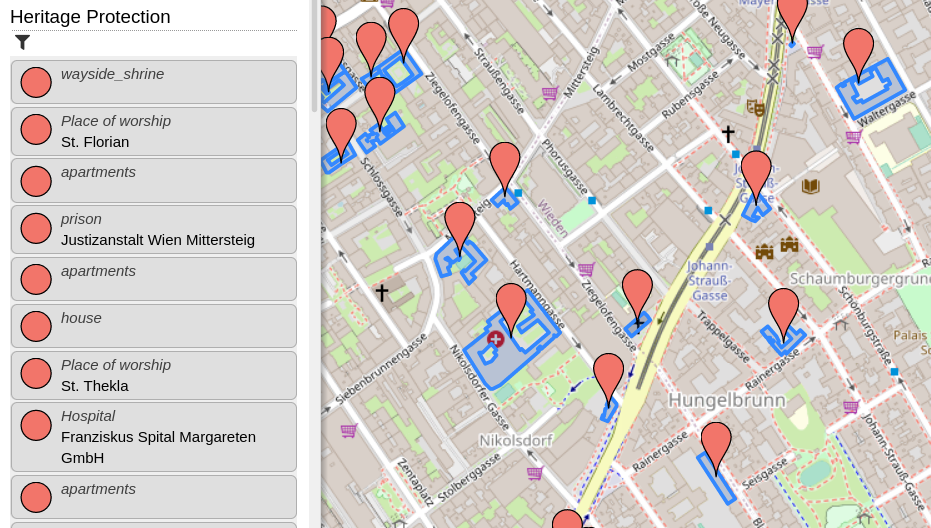
Recently, I added a new category, which shows all heritage protected items (at least those, which are tagged correctly in OpenStreetMap). Additionally, I created a web-application which helps tagging heritage protected items in Austria (and Berlin, Germany). I blogged about this here.

Hace poco instalé Grammarly en mi el computador en el que mapeo, y empecé a ver que no podía usar varios atajos del teclado - shortcuts, y me estaba volviendo loco. Desinstalé JOSM, borré todas las preferencias, cache y demás directorios, volví a descargarlo, cambié definitivamente a OpenWebStart, en fin hice mil cosas.
Había visto que cuando cambiaba de pantalla, sí podía usar la letra “s” de select en JOSM, pero me estaba molestando.
Fue cuando me acordé de este asistente gramatical en inglés, y lo desactivé permanentemente en JOSM (realmente en Java) y ahora todo volvió a la normalidad.

Hello world

On 11 December 2012 LionMapperTeam Nsukka, in collaboration with UniqueMapperNetwork Nigeria, hosted a webinar on Volunteerism and Membership, Talking about Volunteerism a person who works for an organization without been paid for it, because they want to do it. A volunteer is someone who offers to do a particular task or job without been forced to do it. A volunteer Member is a person who is or has been designated by the governing board of an organization and who is faithfully and actually performing volunteer service in that organization. example of a Volunteer Member@ UniqueMapperNetwork, LionMapperTeam, YouthMapperNetwork etc. THE BENEFIT OF VOLUNTEERISM can never be overemphasis it opens opportunities, it Connect you to friends and experts, Create networking, Resume and CV advantage, improve professionalism and develop skills(Soft and Hard skills) expose individual to different skills, give one the advantage of presenting at different summit, workshop, training and seminar.
Today been 27 November 2021, I lead a talk with a team of Lion Mapper Nsukka, Nigeria. on the discuss of OpenStreetMap and HOT Tasking Manager as a tool for free open data mapping and it is free user approach for individual and organizations. OSM and HOT came into existence as an open data source due to lack of data availability about a location, on how to solve environmental issue was a challenge in the 80s. Created in 2004 by Steve Coast in the UK, who initially focus on mapping United Kingdom to help in free and widely distribution of data for everyone to use. OSM is a community owned and supported by OpenStreetMap foundation located in England and Wales. OSM provides geographic data with over 2 million users across the world. OSM and HOT Tasking Manager is open for volunteerism, were Mappers and individual can team up to contribute to open data mapping of their community by providing information about an unknown location via mapping (Mapathon) to be known. Volunteers here in OSM and HOT Tasking Manager help to contribute in open data mapping about disaster management and response of a location, were in turn aid disaster response team and organization to have access to that particular location. Data is save in OSM and HOT Tasking Manager database for future use by Government, NGOs and private organization who are thrilled and concern about the human and natural environment in response to any disaster or environmental challenge about a place which require a location based information.

Strava has recently published its annual report. Like last year it reports a huge increase in users - globally 2 million people join every month, here in the U.K. 17% of the population now use the app. I can’t find a thank you to OSM mappers in the report but nevertheless I think we can take a lot of the credit for its success. The app and all its runners, walkers and cyclists are dependent on the paths and roads that we have mapped and are still mapping. They must surely be one of the biggest groups of OSM users.

My location of home.
Bonjour,
Quels sont les points forts et ppoints faibles de Openstreetmap ? Quelle est son utlisation ? Quel est le type de scr utilisable dans cet outil ? Ppeut-ont ouvrir des shapefils dans cette interface ?
Merci bien à vous
Marie Cath
ฉันขอให้เพื่อนนะนำ ให้ฉันด้วย
Posted by Gonéo on 20 December 2021 in French (Français).
J’ai entamé un travail de mise à jour dans OpenStreetMap des arceaux à vélo de la métropole de Lyon. Il reste beaucoup à faire.
À cette heure je compte 4.091 objets dans le jeu de la métropole versus 3.351 dans le jeu OpenStreetMap. Après analyse le greffon Conflation de JOSM annonce ces chiffres :
- 2.846 correspondances, avec des écarts allant jusqu’à 40 mètres (la limite que j’ai fixée pour le rapprochement)
- 1.245 objets présents uniquement dans le jeu de la métropole
- 505 objets présents uniquement dans le jeu OpenStreetMap
Quand les positions correspondent et que c’est pas déjà renseigné, j’ajoute systématiquement la référence (le champ “nom” du jeu de la métropole) en tant que ref:FR:GrandLyon. Ceci permettra un rapprochement plus fiable par la suite.
Positionnement : Pour les objets que j’ai traités, l’erreur de positionnement se situe parfois dans les données OpenStreetMap, parfois dans les données Métropole, voire parfois dans les 2. Quand les arceaux étaient visibles j’ai recalé les positions dans OSM. J’ai laissé une note=positionnement corrigé par rapport à l'open-data en espérant que ça remonte peut-être un jour à la métropole. Et pour éviter qu’à chaque comparaison on se demande qui a raison. Malheureusement je ne l’ai pas fait au début et il en manque. Je referai une passe.
Suppressions : Il y a des arceaux qui disparaissent suite à des réaménagements de voirie. Ils sont supprimés du jeu Métropole mais ils sont encore présents dans les données OpenStreetMap. Quand j’ai un doute je laisse un fixme=resurvey, que je double avec une note demandant de confirmer si les arceaux existent encore. Ça peut faire doublon mais le fixme est plus facile à utiliser pour les requêtes, tandis que la note est plus visible pour les contributeurs qui sont sur le terrain.
Nova dalnice jaromer Hradec Kralove je jiz otevrena
日本国内の市町村内にある町名・字名(以下、地名とします)の登録がほとんどの市町村において完了しました。
国内の地名の登録は2012年頃から位置参照情報(以下、ISJ)のインポートという形で始まったようです。 osm.wiki/Import/Catalogue/Japan_ISJ_Import
その後長く動きはなかったようですが、nyampireさんのISJ 2019のインポートが2021年に動き始めました。 osm.wiki/JA:MLIT_ISJ/import2019_outline
私は2019年にOSMを始め、地図に地名さえ載ってないのは寂しいな、使いづらいなと思っていたので、当初から少しずつ地理院地図のトレースという形で地名の登録を始めました。 しかし、地名の手入力というのは果てしなく時間がかかるものです。
ということで、ISJ 2019のインポートが始まってからほどなくして、私もそのインポート作業をお手伝いすることにしました。 そしてようやく2021年11月に5つほどの市を除く全市町村への位置参照情報掲載の地名を登録終えました。
そのインポート作業をする中で、いくつかのエリアで新たな町名ができたことを知ります。 そして、新町名の情報をネット検索すると、出るわ出るわ、結構あちこちでしているようです。 要因としては住宅地が新たにできることで住居表示の実施をしたり、区画整理や町界町名整理などに伴う、新町名の設定などがあります。
そこで、概ね2018年以降設置された新町名について、その項目と地理院地図やISJ、OSMへの登録状況をまとめてみました。 osm.wiki/JA:Chimei_placename
これを見るとISJや地理院地図にいつ頃の分まで登録されているなとか、抜けているのもあるなということが見えてきます。 当面はこのリストを元にOSMへの地名の登録あるいは確認を行うことで、最新情報を保っていきたいなと思います。

The street complete app makes filling out data for OSM really fun. This was unexpected. I thought it was just going to be a more convienent way to enter data, but it’s also oddly satisfying.

Don’t forget to get some of your only one 🕜