Users' Diaries

Recent diary entries

State of the Map - Eastvale

  1. Roads - Currently they are mapped and seem to be fairly accurate
  2. Buildings and Businesses - Currently building and businesses are mostly mapped
  3. Residential Housing - Eastvale is lacking addresses, residential housing areas

Currently I’m dedicating my time to add address and residential housing to OSM as Eastvale is heavily lacking basic navigation
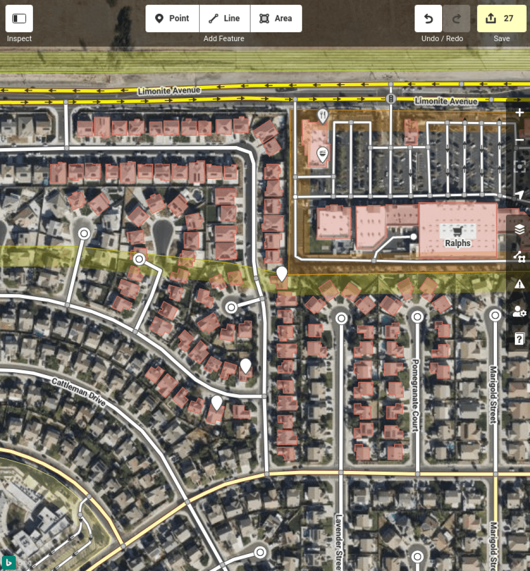
27 New Houses and Addresses Mapped!

Location: Eastvale, Riverside County, California, 92880, United States
Posted by 0235 on 22 November 2021 in English.

A few weeks ago I was told by a Lorry driving friend that a new Truck only service station had opened nearby. I was quite surprised as Lorry driving infrastructure is normally not the best in the UK, and I was quite surprised to see a brand new facility.

Based on dash-cam footage they showed me and Bing aerial images, I attempted to get as much information as possible.

Before:

See full entry

Location: Rothwell, North Northamptonshire, England, United Kingdom

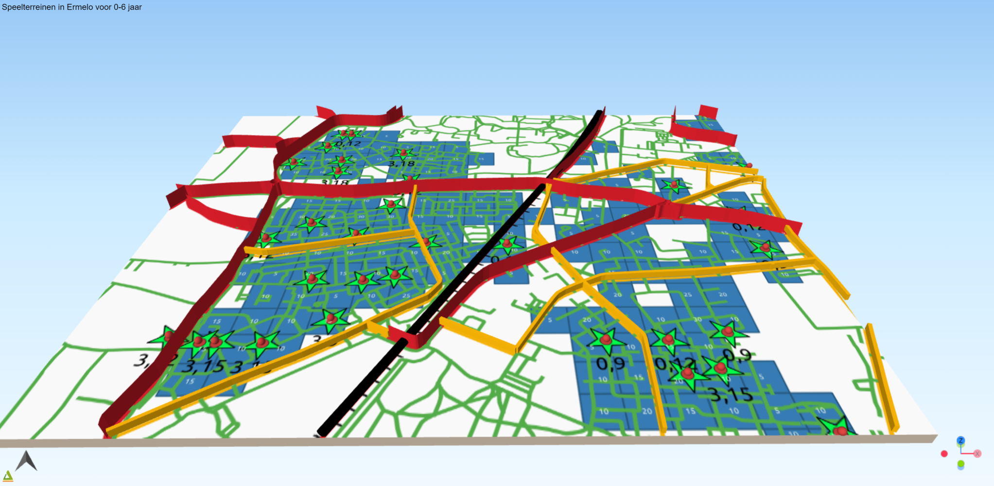
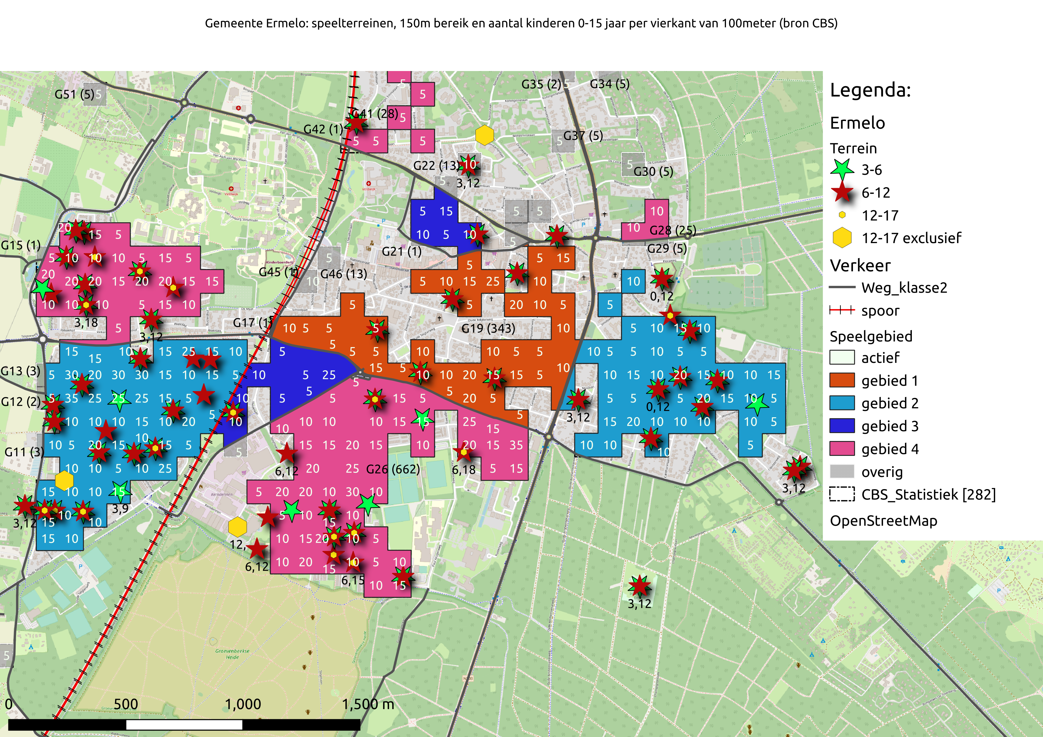
In een vorige blog post ben ik begonnen over burgerparticipatie. Kernidee is dat de burger zelf meer initiatief neemt, niet wacht op een uitnodiging van de gemeente, zelf op zoek gaat en met ideeën komt. In dit artikel schrijf ik hoe ik de speelvoorzieningen in de wijk heb geïnventariseerd. Mijn doel is om er voor te zorgen dat er voldoende speelmogelijkheden in de woonwijk komen en dat deze daar blijven.

Blog: Artikel Breng je buurt in kaart en doe er wat mee 3D kaart

Posted by -off- on 21 November 2021 in Russian (Русский). Last updated on 29 November 2021.

В Ростовской области МЧС и ДПЧС РО это отдельные структуры. Причины этого не выяснял. Также пока не изучал структуру МЧС.

Для спасателей на воде использую следующие тэги: amenity=rescue_station emergency=lifeboat_station name=Вешенское поисково-спасательное подразделение operator=Департамент по предупреждению и ликвидации чрезвычайных ситуаций Ростовской области branch=ГКУ РО «Ростовская областная поисково-спасательная служба во внутренних водах и территориальном море Российской Федерации» official_name=Вешенское поисково-спасательное подразделение государственного казенного учреждения Ростовской области «Ростовская областная поисково-спасательная служба во внутренних водах и территориальном море Российской Федерации»

Для пожарников amenity=fire_station name=Пожарная часть №xxx operator=Департамент по предупреждению и ликвидации чрезвычайных ситуаций Ростовской области branch=ГКУ Ростовской области “РО ПСС” official_name=Пожарная часть 233 государственного казенного учреждения Ростовской области «Противопожарная служба Ростовской области»

Для сухопутных спасателей (основная деятельность - спасение при ДТП) amenity=rescue_station name=xxxxxxx поисково-спасательный отряд или пожарно-спасательный отряд operator=Департамент по предупреждению и ликвидации чрезвычайных ситуаций Ростовской области branch=ГКУ РО «Ростовская областная поисково-спасательная служба» official_name=Вешенское поисково-спасательное подразделение государственного казенного учреждения Ростовской области «Ростовская областная поисково-спасательная служба»

Для полного счастья можно добавить в контактные данные странички в соц.сетях - у некоторых пожарных частей есть инстаграмм.

http://127.0.0.1:8111/import?url=https://www.openstreetmap.org/api/0.6/changeset/110974517/download Ссылка для скачивания в JOSM набора правок. Номер в ссылке вставлять свой.

漢字版

中國遐有人寫日記哼(hainn)有大量學生佇中南大學畫地圖,看起來是老師按學生畫學校附近,但是缺少 QA 的程序,予袂少有問題的資料無人插。這是早慢欲面對的問題,社群愛動員去修理,抑是畫甲傷䆀做理由攏刣刣掉矣。嘛會使揣 Data Working Group 協助,共講袂聽的口座封一寡時間,予社群成員有時間清理佮修正。

臺灣遮的經驗是,共一寡看起來是學生做學校指定作業的口座溝通,用變更集留話,通常是無回應的。對社群來講有時間就直接修改好勢,閣來研究𪜶是對佗位來的。無想欲改就攏總刣掉嘛無要緊,必要時予 Data Working Group 處理,處理無回應閣繼續編織的口座,至少無予問題擴大。

會記得臺灣遮上嚴重的底代是美光團,用 HOT Task Manager 佇咧畫彰化,雲林遐的建築,最後因為問題建築傷濟矣,無法度修改好勢,予 Data Working Group 資料攏刣刣掉。

其他的代猶閣有彰化遐學校學生的編輯團,一直毋知是佗位的學校咧畫。猶有人加上心理醫療場所的POI,嘛是有一寡問題,因為應該是共地址用 Google 轉成經維度,資料的授權有淡薄仔問題。

OSM Wiki有組織編輯指引,有團體愛編輯,著愛登記佇 Wiki 頁面,愛留𤆬頭的人聯絡資料,目的,佮時間。臺灣環境資訊協會的啉水地圖計畫就有留資料登記。組織編輯指引應該是 OpenStreetMap 生態系內底,會當參考佮遵守的指引,嘛會當參考別人是按怎處理的。

上好是揣著頭,共老師好好矣溝通,老師愛知影 OpenStreetMap 予袂少重要的網站使用,學生貢獻是愛頂真,袂使清彩處理。通常予學生畫較簡單的事物,親像講學校,徛家附近的店家,莫予學生畫傷複雜,傷大的範圍。

又閣有中國的環境無允准一般人來畫地圖,個人畫地圖是違反𪜶的法律。愛揣到頭人佇Orgaizated Editing Guideline頁面登記,感覺毋是傷好的處理方式。另外學生個人號口座用真實姓名抑是問題。佇中國的網路環境,線頂的口座號一个代號較好,莫用真實姓名號口座的名號是較好的做法。

Tâi-lô-pán

Tiong-kok hiah ū-lâng siā ji̍t-kì hainn ū tuā-liōng ha̍k-sing tī Tiong-lâm Tāi-ha̍k uē tuē-tôo, khuànn-khí-lâi sī lāu-su àn ha̍k-sing uē ha̍k-hāu hù-kūn. Tse-sī siā-kûn tsá-bān bueh bīn-tuì ê būn-tê, siā-kûn ài tóng-guân khì siu-lí, ia̍h-sī uē kah siunn-bái tsuè-lí-iû lóng thài-thài-tiāu ah. Mā ē-sái tshē Data Working Group hia̍p-tsōo, kā kóng-buē-thiann ê kháu-tsō hong tsi̍t-kuá sî-kan, hōo siā-kûn sîng-guân ū sî-kan tshing-lí kah siu-tsìng.

Tâi-uân tsia ê king-giām sī, kā tsi̍t-kuá khuànn-khí-lâi sī ha̍k-sing tsuè ha̍k-hāu tsí-tīng tsok-gia̍p ê kháu-tsō kau-thong, iōng piàn-king-tsi̍p liû-uē, thong-siông sī bô huê-ìng ê. Ū-sî-kan tō ti̍t-tsiap siu-kái hó-sè, koh-lâi gián-kiù in tuì tó-uī lâi ê. Bô siūnn bueh kái tō lóng thâi-tiāu mā bô iàu-kín, pit-iàu sī hōo Data Working Group tshú-lí, tshú-lí bô huê-ìng koh kè-sio̍k pian-tsi̍p ê kháu-tsō, tsì-tsió bô hōo būn-tê khok-tāi.

See full entry

Location: 桔子洲街道, 岳麓区, 湘江新区, 岳麓区, 长沙市, 湖南省, 中国

本文首发于中华人民共和国的wiki页面

本wiki页面有非常详尽的行政区划标签使用方法,但是仍然还有争议,而且与其它wiki页面的解释完全不同。造成目前地图编辑时,不同城市的不同编辑者描述同一事物(如标注社区、街道、自然村、开发区时)经常使用不同的place标签。为统一标准,避免重复工作,现发起如下讨论。

本讨论旨在解决以下问题:

  • 目前有20个国家级新区使用place=cityplace=suburb,是否需要统一为place=city。以及是否需要扩大对于市级和区级开发区的适用范围。

  • 在村级自治组织,建成区与其他社区相接的社区使用place=quarter, 建成区独立于建成区的社区使用place=village是否有问题,以及目前村委会统一只使用place=village,是否也有必要进行上述和居委会一样的区分。

  • 强调自然村和行政村需要使用不一样的标签,对自然村的标注要强调根据规模不同使用place=hamletplace=isolated_dwelling两种不同标签。

  • 在上述几个问题解决后,需要确定是否有必要根据Key:place和子章节的内容为place=boroughplace=suburbplace=quarterplace=neighbourhoodplace=city_block等标签做中国化的单独定义(决定标签用于哪个行政等级,以及确定与原生标签place=city、place=town、place=village在定义上如何区分)亦或者选择将那些标签弃之不用。

除了在wiki讨论页讨论以外,也可在QQ群或电报群讨论,目的是让尽可能多中文用户就以上问题达成社区共识,避免再发生编辑上的标准冲突。

Posted by SK53 on 18 November 2021 in English.

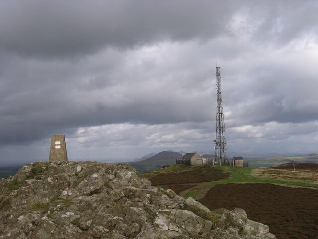
Whilst writing my previous post on Welsh Heaths I discovered that a hill on the Llŷn Peninsula shown as heath in the Phase 1 survey has no landcover mapping on OSM. I walked up Myndydd Rhiw in 2008, just before I started contributing to OSM – so I failed to take enough photos. The weather was not very good that day so I’d opted for a car journey to visit locations on Llŷn rather than brave the rain in Snowdonia. Rhiw was the only place which wasn’t chosen because of personal associations: not only had we holidayed there several times during my childhood, but my great-grandmother’s family come from Llŷn,

Summit of Mynydd Rhiw Summit of Mynydd Rhiw

See full entry

Location: 52.833, -4.631

originally published in Portuguese Link

Today I am completing two years as an OpenStreetMap contributor so to celebrate I will make a brief retrospective about this last year. 2021 was not an easy year for the Brazilians with the negligence of the government we reached the mark of 600k dead by Covid-19, besides the return of hunger and high inflation but as Belquior would say I can consider myself lucky, editing in OSM gave me strength to endure many things, mapping this year was like a therapy. This year I also had the opportunity to meet incredible projects and people!

Statics

Some numbers:

  • 22,503 edits
  • 170,425 buildings mapped
  • 15.202 Km of roads mapped
  • 9.926 Points of interest mapped
  • 4,323 Km of rivers mapped

What happened to Mapeia.Space?

It is a complicated story, first we had to change after DAMN totally changed the way we work and as Hot TM seemed to have matured in the performance issue so we decided to switch to Tasking Manager what happened is that we had to start from scratch again… we had a problem with our hosting at the same time I received the invitation to use HOT Tasking Manager (Thanks Wille and Vitor George for this opportunity) since then there were 7 published projects. Then there was no reason to maintain an own instance of Tasking Manager so the mapeia.space was closed although I tried to create an organization around Mapeia to promote mapping which also didn’t work but in the end it ended up giving as a fruit of research on the use of online maps.

You can visit the profile of OSM Brasil at Tasking Manages link

Importation?

See full entry

Location: Santo Antônio, Timon, Região Geográfica Imediata de Timon, Região Geográfica Intermediária de Caxias, Maranhão, Northeast Region, Brazil

Anche quest’anno, volevo trovare i mapper attivi nella nostra zona, per invitarli agli incontri mensili del nostro gruppo.

Ho usato la stessa procedura che avevo già descritto in questo blog.

Considero attivi gli utenti che hanno inserito almeno 100 nodi e con l’ultimo edit effettuato nel corso di quest’anno.

Nel 2021 ci sono stati 121 utenti attivi. 22 sono già regolarmente contattati per i nostri incontri, 42 dovrebbero essere mapper locali, 24 dovrebbero risiedere in zone limitrofe, 32 sono mapper remoti e non è stato possibile trovare un utente. Escludendo gli account di import, 302 utenti non sono più attivi (ovvero non hanno fatto almeno un edit nel 2021).

Rispetto allo scorso anno, ci sono stati 22 mapper attivi in più. Quasi la metà degli utenti però non risiede in zona, molti sono stranieri. Sulla tipologia di queste modifiche ci sarebbe da parlare a lungo. Altri 15 utenti hanno smesso di contribuire.

A differenza della scorsa volta, volevo contattare gli utenti attraverso la messaggistica di OSM in modo automatico (copiare e incollare lo stesso testo per inviarlo a tanti utenti differenti è veramente una perdita di tempo).

Per fare questo ho modificato greeter_osm, uno script python che utilizza il feed newesttoosm e invia un messaggio di benvenuto ai nuovi utente. Il tool faceva già moltissimo. E’ bastato togliere tutto quello che c’era in più e aggiungere le poche cose che mancavano.

Il risultato è osm_bulk_sender. Per il momento lo script è privato perché non vorrei che fosse usato impropriamente. Da grandi poteri derivano grandi responsabilità.

I’m undertaking a bit of a project in Burnie, a city in the state of Tasmania in Australia, and thought that I should leave a more public note about what I’m doing and the reasoning behind it. Don’t expect anything particularly entertaining from this entry. The short version: a recent import of official suburb boundary data can be used to accurately offset aerial imagery, which can in turn be used to consistently align existing mapped items across the city.


While there are other mappers in the area, and I was most active in OSM mapping several years back, I’m responsible for a decent amount of data in the Burnie area. My process was pretty straightforward: drive to a new area, survey on foot, record GPS traces as I went. Back home I would upload the address data and anything else that needed updating and trace buildings from imagery. The best-quality imagery at the time was Bing, which was fairly average resolution and not always well-aligned, so I’d align the map to my GPS traces or publicly uploaded ones, depending on subjective recording quality. While this was in good faith, it meant that each little area I’d surveyed tended to have slightly different offsets, with no way for me to tell if any were correct. It’s minor, but many of the buildings I traced are also poorly outlined, though the older imagery probably limited how well I could do at the time.

Having resumed OSM mapping recently (after moving house - what better motivation than having a new neighbourhood to explore?) nobody had done much to improve this issue. Not surprising; it’s not the most populated area, things were good enough for routing purposes, and there was plenty that still wasn’t mapped at all. But it bothered me, and I noticed a new feature that made it much easier to resolve.

See full entry

Location: Montello, Burnie, City of Burnie, Tasmania, 7320, Australia
Posted by LCCWG on 17 November 2021 in English.

Welcoming new mappers

TLDR: It’s now super easy to welcome new mappers in your country or region. Just post an issue at the Welcome tool repository, and we’ll set you up. New mappers will be listed and in a few clicks you can check their work and welcome them with a localized welcome message. You can share the workload, as it will be clear who is and who hasn’t been contacted. Try it out at https://welcome.osm.be/ (don’t forget to connect your OSM account). Instructions on how to request your region available here.

About the tool

Back when we started doing real life meetings in Belgium, one of the first frustrations was how hard it was to get in touch with mappers. How do you let mappers know there’s a group of locals who are eager to get to know them? And how do we offer a helping hand to new mappers?

Of course, the first thing you think about is automating, plugging in to the global OSM software. But that software evolves slowly and you’d have to come up with a solution that works worldwide from the start.

So we decided to go for a simple solution: Belgian mapper M!dgard built a simple tool in PHP around Pascal Neis’s RSS feed of new mappers. M!dgard never stopped hating the ugly coding, but it did do the job for several years - with Jakka doing most of the welcoming work.

Don’t expect welcoming new mappers to be very rewarding. Most new mappers are never going to stick around, so just a few percent will ever answer you. Statistically speaking, there doesn’t seem to be an impact on mapper retention either. But we always felt that it does help people to find their way in the documentation and in the communication channels. Not in the least, we used the tool to monitor the edits of new mappers. That helped us spot errors as well as occasional vandalism.

See full entry

Posted by TauvicR on 17 November 2021 in Dutch (Nederlands).

Met de Omgevingswet krijgen burgers nieuwe mogelijkheden om invloed uit te oefenen op beslissingen over hun leefomgeving. Burgerparticipatie is een door de gemeente of projectontwikkelaar geregisseerde activiteit, meestal aan het einde van een lang planning en voorbereidingstraject. Dit geeft de indruk dat er nog maar weinig bij te sturen valt.

Maar wat als burgers zelf plannen gaan ontwikkelen? In dit artikel beschrijf ik wat burgers zelf kunnen doen met hulp van openbare data en open source software.

https://tauvicr.wordpress.com/2021/11/16/burgerparticipatie-nieuwe-stijl/

De Buurkaart