 OpenStreetMap

In case you are wondering what I am scheming with my recent changesets, I have started converting individually-named bodies of water on the Atlantic coast of Canada to relations. I started with Cobequid Bay, progressed out the Bay of Fundy to Passamaquoddy Bay and St. Marys Bay, and I have subsequently rounded Cape Sable Island and gotten as far northeast as Liverpool Harbour, progressing towards Halifax. What I am intending to do with this series of edits is to make relations for bodies of water throughout the entire coast of Canada, from the Bay of Fundy all the way to the Beaufort Sea. I have already done this for the Pacific coast, and I figured I might continue this through the rest of the coastal areas of the country. And this little pet project is going to take quite a bit of time to complete, given just how vast Canada is and how much coastline she has, the most out of any country in the world.
Users' Diaries
Recent diary entries

The Grind
After 13 days I today finished my review of all streets in Mülheim an der Ruhr, added the street name origin and roadkey ger: “Straßenschlüssel” where possible.
I have been casually adding street name origins for some time, an interesting topic if you are into history I think. At some point I set out to review all streets from A-Z, and while doing that add the roadkey too, as described in osm.wiki/DE:Key:de:strassenschluessel
Orientation and inspiration came from osm.wiki/Düsseldorf/Projekte/Straßennamen
Gladly Mülheim provides a list that had both, a name origin hint and a reference from that I could get the roadkey, on their website: https://geo.muelheim-ruhr.de/node/14033
Along the way I made some minor additions, on about 4 occasions OSM didn’t have the street name or was missing renames for instance.
After having worked through the list I verified the presence of “Straßenschlüssel” by Overpass:
[out:csv("name",
         "de:strassenschluessel_exists",
         "de:strassenschluessel",
         "local:strassenschluessel",
         "wikidata",
         "wikipedia",
         "wikimedia_commons",
         "name:etymology:start_date",
         "name:etymology:wikidata",
         "name:etymology:wikidata:missing",
         "name:etymology:wikidata:note",
         "name:etymology:wikipedia",
         "name:etymology:description",
         "name:etymology:note";
         yes;
         "|"
        )]
[timeout:250];

{{geocodeArea:Mülheim an der Ruhr}}->.searchArea;

(
  wr[highway]
    [highway != platform]
    [name]
    [!"de:strassenschluessel"]
    ["de:strassenschluessel_exists" != "no"]
    (area.searchArea);
);

out geom;

sdss

The Compound

Mentre mi muovo per la città approfitto per migliorare la mappa aggiungendo note qui e là. Mi viene in aiuto StreetComplete.


Go Map!! is now a desktop app for Mac, in the App Store: https://apps.apple.com/us/app/go-map/id592990211
Did anybody ask for a desktop version? In fact a few people did, but the primary reason to release it is “because we can.” Many people edit using iPad, and many of those people use mouse/keyboard, so adding support for those input methods got the app 80% of the way to full desktop support. Enjoy!


If you have a beautiful bunny sadly you can’t take them to a regular vet. You need “exotic experts”. This is true at least in Italy.
That’s why I tried to expand an OpenStreetMap RFC about veterinarians, to cover this case.
The result? See with your eyes:
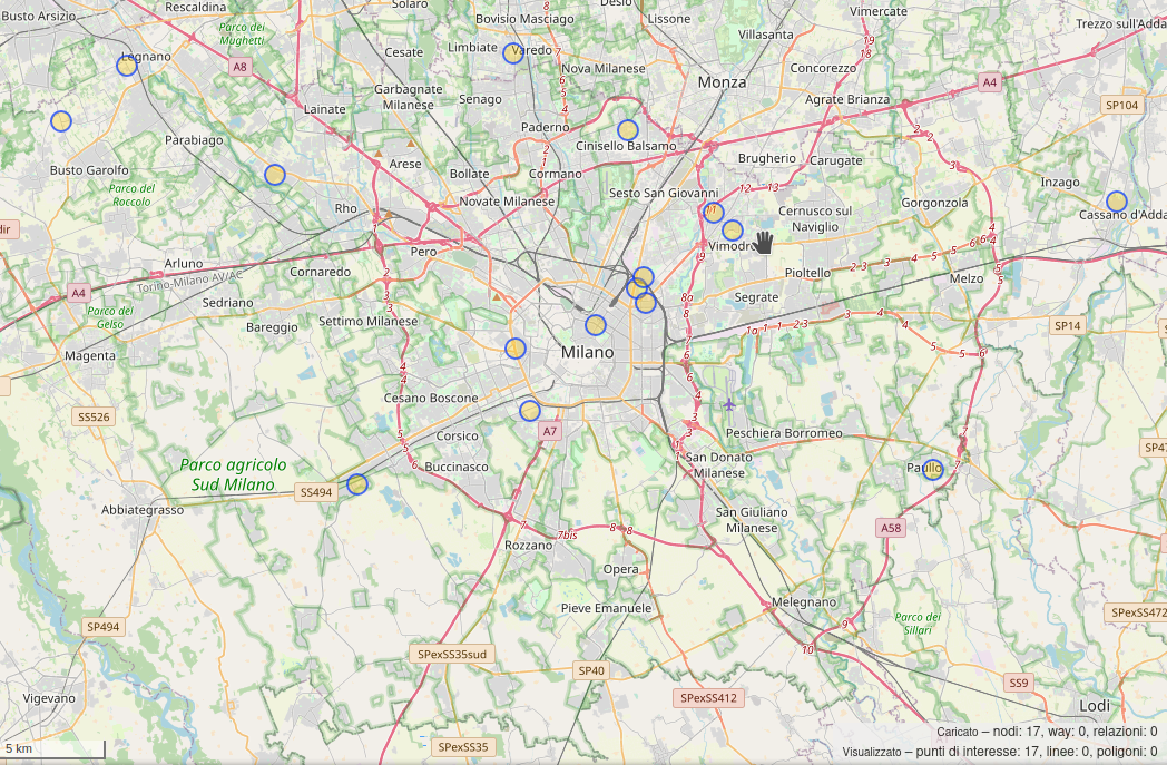
https://overpass-turbo.eu/s/1c7F
It’s absolutely amazing how somebody can expand OpenStreetMap so quickly to add useful metadata and being able to query them in realtime.
https://overpass-turbo.eu/s/1c7F
Happy bunny!🐇
قرى وادي مقسى قرى سعودية، تتبع محافظة ميسان بمنطقة مكة المكرمة. تقع في جنوب غرب مدينة الطائف بمسافة (90 ) كم.[1]
بنيوس الغورية ويقصد بهم ( المجافية ـ آل شداد ـ المفارجة ـ العبدة ـ السواهر ـ العبد الله ـ العلثى ـ الضبعة )

S
Village comes under Pusad Tahasil of Yavatmal District, Maharashtra, India,

This entry will be constantly updated based on my findings in USA.
Please be advised that a correct solution depicted below is not the only one. You are welcome to brainstorm in the comment section!
Hint: Right click on the picture to view in a new tab so you will see it in a better size.
1:
Wrong:

The reason why the intersection originally looks like this is to prevent reckless driving in rural area.

| Versões: English / | French / | HOT website (English) |
Juntamente com as comunidades/contribuintes locais do Vietname, Madagáscar e Moçambique, e os Centros Mapas Abertos (Ásia-Pacífico, e África Oriental e Austral), tenho muito prazer em partilhar convosco a colaboração Projecto: Localização como um facilitador de inclusão e participação (também disponível em Francês, Português e Espanhol).
Resumo dos detalhes do projecto:
Contexto
A barreira linguística e a omissão do inglês coloca os não falantes de inglês em desvantagem sistémica nas comunidades de mapeamento aberto e nas actividades humanitárias de mapeamento aberto que o HOT tenta apoiar, resultando numa falta significativa de participação e impacto (Gayton, 2021) .
Motivação
Acreditamos que a localização linguística permitirá a inclusão e participação de grupos subrepresentados no mapeamento, diálogos e outras actividades humanitárias de mapeamento aberto.
Objectivo
O nosso objectivo é desenvolver dados de base para informar uma estratégia de localização*** auto-sustentável para colmatar a lacuna entre linguagem e acessibilidade dos recursos de cartografia aberta que servem as comunidades envolvidas no trabalho humanitário / de desenvolvimento (ver Países Prioritários do HOT).
Metodologia
Iremos realizar pequenas experiências (isto é, fluxos de trabalho de tradução, e compromissos) com comunidades locais para testar como a localização de recursos poderia funcionar nas principais línguas de 3 países prioritários: Vietname (Tieng Viet), Madagascar (francês) e Moçambique (português).
Linha do tempo (sujeito a alterações)
- June-Julho: brainstorming inicial, preparação e análise dos requisitos (completo)
- *Agosto - Setembro:** Compromissos com as comunidades como colaboradores nas experiências (completo)
- Outubro - Novembro:** Experiências/Translações em curso
| Versions: English / | Portuguese / | HOT website (English) |
Avec les communautés locales/contributeurs du Vietnam, de Madagascar et du Mozambique, et les centres Open Mapping (Asie-Pacifique, et Afrique de l’Est et Afrique australe), je suis très heureux de partager avec vous la collaboration Projet : La localisation comme outil d’inclusion et de participation (également disponible en français, portugais et espagnol).
Résumé des détails du projet :
Contexte
La barrière de la langue et le choix par défaut de l’anglais désavantagent systématiquement les non-anglophones dans les communautés de cartographie ouverte et les activités de cartographie ouverte humanitaire que HOT tente de soutenir, ce qui entraîne une participation et un impact manqués (Gayton, 2021).
Motivation
Nous pensons que la localisation de la langue permettra l’inclusion et la participation des groupes sous-représentés dans la cartographie, les dialogues et autres activités de cartographie ouverte humanitaire.
Objectif
Nous visons à développer des données de base pour informer une stratégie de localisation autonome afin de combler le fossé entre la langue et l’accessibilité des ressources de cartographie ouverte qui servent les communautés impliquées dans le travail humanitaire / de développement (voir [Pays prioritaires de HOT] (osm.wiki/Humanitarian_OSM_Team/Working_groups/Community/Terms_of_Reference#How_we_define_our_community_focus)).
Méthodologie
Nous allons mener de petites expériences (c’est-à-dire des flux de travail de traduction et des engagements) avec les communautés locales pour tester comment la localisation des ressources pourrait fonctionner dans les principales langues de trois pays prioritaires : Vietnam (Tieng Viet), Madagascar (français) et Mozambique (portugais).
Calendrier (sous réserve de modifications)
Juin-Juillet: Brainstorming initial, mise en place et analyse des besoins (terminé)
| Versions: French / | Portuguese / | HOT website (English) |
Together with the local communities/contributors from Vietnam, Madagascar and Mozambique, and Open Mapping Hubs (Asia-Pacific, and East & Southern Africa), I am very happy to share with you the collaboration Project: Localization as an Inclusion and Participatory Enabler (also available in French, Portuguese and Spanish).
Summary of the project details:
Context
Language barrier and the default to English puts non-English speakers at a systemic disadvantage throughout open mapping communities and humanitarian open mapping activities that HOT tries to support, resulting in significant missed participation and impact (Gayton, 2021) .
Motivation
We believe that language localization will enable inclusion and participation of underrepresented groups in mapping, dialogues and other humanitarian open mapping activities.
Goal
We aim to develop baseline data to inform a self-sustainable localization strategy to bridge the gap between language and accessibility of Open Mapping resources that serve communities involved in humanitarian / development work (see HOT’s Priority Countries).
Methodology
We will be running small experiments (i.e. translation workflows, and engagements) with local communities to test how localisation of resources could work in the main languages of 3 priority countries: Vietnam (Tieng Viet), Madagascar (French) and Mozambique (Portuguese).
Timeline (subject to change)
- June-July: Initial brainstorming, set-up and analysis on requirements (complete)
- August- September: Engagements with communities as collaborators in the experiments (complete)
- October - November: Experiments/Translations running
I can’t find my neighbors house or my front yard. Yep! This seems perfect for me
Data
## G. Montesanto leg.

It was great going through the challenges in part 1. We have a few more interesting tasks as the next maproulette challenges for you all. They are for mappers who are just starting or are experienced. Here are the tasks for you all:

- Connectivity checks: https://maproulette.org/browse/challenges/21203
- Building-Road intersection checks: https://maproulette.org/browse/challenges/21201
- Inconsistent Road Classification checks: https://maproulette.org/browse/challenges/21207
- Intersecting Buildings checks: https://maproulette.org/browse/challenges/21208
- Correcting mixed name case: https://maproulette.org/browse/challenges/21215
- Connectivity checks: https://maproulette.org/browse/challenges/19892
- Invalid Turn restrictions checks: https://maproulette.org/browse/challenges/19890
Put your mapping hats on and let’s do some mapping!
We would love to hear suggestions and feedback from you on these tasks so that we could better ones next time.

W tym poradniku dowiesz się, jak przy pomocy programu QGIS i wtyczki mbtiles w JOSM zmienić wybrany rysunek projektowy…

…w podkład do JOSMa.

- szavazás: https://cloud.systest.eu/apps/polls/s/eU7bkvkXWp7t348K
- 11:45-12:15 szendvics OE NIK aula;
- 12:15-16h terepezés;
- 16-18h evés-ivás-tudáscsere;
- 18-20h terepezés