Users' Diaries

Recent diary entries

Introduction

I started google summer of code with the aim of creating a library that can be easily added to Vespucci and provide it with element comparison features, and provide some other feature requests in Vespucci. I was able to create and deploy the Element History Dialog, which can be found here, where you can find the implementation details for the library.

Work Done

The major work done during the coding period includes the following -

  1. Creating the parser for OSM elements
  2. Creating the parser for Changesets
  3. Creating the UI to list all versions for a selected OSM element
  4. Creating the UI for comparison between different OSM elements
  5. Logic for comparison between tags of different versions of a element
  6. Logic for comparison between data for 2 versions of a node
  7. Logic for comparison between data for 2 versions of a way
  8. Logic for comparison between data for 2 versions of a relation
  9. Handling edge cases like deleted elements and versions
  10. publishing the library and creating the sample application

A more detailed usage guide can be found on the github readme

Future Scope

Some additions to the project that I plan are -

  1. Creating more test cases - currently there are a few unit tests that test the basic functionality of the app, I will add more unit tests to cover most logical operations and few UI tests to test the basic flow of the library
  2. Adding the library to vespucci
  3. Creating Pull Requests on Vespucci for other features mentioned in my gsoc application.

Finally, I would like to say that my experience with the OSM community has been great, and I would love to contribute more to the great projects that are hosted by OSM

Posted by CjMalone on 23 August 2021 in English.

I’ve been working on collecting datasets for various chains across the UK, and the globe. Yesterday I changed the repo to open, so say hello to KAFF Places. It’s mainly got retail chains, but it also some hotel chains, pharmacies and the like. You can see the list here.

This data is first party from their respective websites, interestingly enough there are a lot more quality issues that come with that than I expected. I have reached out to some of them to point out issues, and I’d love to work with all of them to improve their data.

I’m waving any database rights I may have, but because this is first party data each provider holds copyright and/or database rights. I currently do have some rules on which sites I collect data from, the most important rule is that they are publishing the data in Linked Data or Microdata. I personally believe once somebody explicitly publishes data in a machine readable format they want the data to be used. However the law may disagree. This shouldn’t be used as a source for OSM.

Some of this data is already being used by Robert Whittaker in Chain Reaction to help monitor the quality of OSM coverage. I’d also like to see this data being used as an overlay on top of OSM data to increase coverage in under mapped areas, in projects like OsmAnd and Daylight Map Distribution.

Posted by DeBigC on 23 August 2021 in English. Last updated on 24 August 2021.

I map a lot of buildings in northern Dublin City. I also interrogate housenumber interpolations, view mapillary for little peeks of the housenumbers that aren’t blurred, and do my own StreetComplete captures to add as many address details as possible. Lately I have noticed something, born from a concern that I was doing something wrong, or making a mistake.

In a few housing developments around Dublin housenumber=13 doesn’t exist. I have heard of such indulgences before, for example some airlines dropping row 13 from seating plans, or the Irish car registration authority famously dropping its numeric system in 2013 to avoid the unluckiest of car numbers.

So out of curiousity I hit OverPass Turbo and launched a series of queries like this into the existing housenumbers. I couldn’t do loads of these so I thought that maybe 19 would be a sufficient sample (42,000 building objects) to make comparisons and establish patterns. snip1

See full entry

Posted by SimonPoole on 23 August 2021 in English.

Today we’ve started rolling out the 1st beta release of 16.0. If you intend to install this, or at a later date the release version, please read the release notes http://vespucci.io/help/en/16.0.0%20Release%20notes/ before installing.

Due to the preparation for targeting Android 11 there have been some changes in where files are stored that you need to know about.

漢字的版本

最近毋知是按怎,近期的 zh-CN 日記出現誠濟篇指控 OpenStreetMap 無遵守中國的法律,竟然共台灣標示是獨立的國家。

臺灣人看著這款指控真無爽快,不而過猶是有精神來回應,是講 OpenStreetMap 的政策、運作方式佮精神,特別是爭議領土欲按怎處理的方式。

Pe̍h-ōe-jī ê pán-pún

Chòe-kūn m̄-chai sī án-chóaⁿ, kūn-kî ê zh-CN ê ji̍t-kì chhut-hiān chiâⁿ-chōe phiⁿ chí-khòng OpenStreetMap bô chun-siú Tiong-kok ê hoat-lu̍t, kèng-jiân kā Tâi-oân piau-sī sī to̍k-li̍p ê kok-ka.

Tâi-oân-lâng khòaⁿ-tio̍h chit-khoán ê chí-khòng chin-bô sóng-khoài, put-lî-kò iáu-sī ū-cheng-sîn lâi hê-èng, sī-kóng OpenStreetMap ê chèng-chhek, ūn-chok hong-sek kah cheng-sîn, tek-pia̍t sī cheng-gī léng-thó͘ boeh án-chóaⁿ chhú-lí ê hong-sek.

Tâi-lô ê pán-pún

Tsuè-kūn m̄-tsai sī án-tsuánn, kûn-ki ê zh-CN ê ji̍t-kì tshut-hiān tsiânn-tsuē phinn tsí-khòng OpenStreetMap bô tsun-siú Tiong-kok ê huat-lu̍t, kìng-jiân kā Tâi-uân piáu-sī sī to̍k-li̍p ê kok-ka.

Tâi-uân-lâng khuànn-tio̍h tsit-khuán ê tsí-khòng tsin-bô sóng-khuài, put-jî-kò iáu-sī ū tsing-sîn lâi hê-ìng, sī-kóng OpenStreetMap ê tsìng-tshik, ūn-tsok hong-sik kah tsing-sîn, ti̍k-pia̍t sī tsing-gī líng-thóo bueh án-tsuánn tshú-lí ê hong-sik.

Location: 天峻县, 海西蒙古族藏族自治州, 青海省, 817200, 中国
Posted by AntoJvlt on 22 August 2021 in English. Last updated on 23 August 2021.

Introduction

As we are reaching the end of the Google Summer of Code 2021, I would like to share with you the work done on my project “Nominatim QA Analyser”.

Previous diary entries

Project summary

Nominatim is the OSM’s main geocoding software used to process geocoding requests on OpenStreetMap data. The software uses its own database schema which differs from the one used by the main OSM database. As a result, Nominatim processes OSM data in a way that allows to discover a lot of inconsistencies. The idea of the project was to build a Quality Assurance Tool which analyzes the Nominatim database and extracts errors from the OSM data based on a set of rules.

These extracted errors are then made available to everyone through a visual map, so that OSM mappers can correct them easily.

Running example

If you are curious about the result of the project, you can check a running instance here: https://gsoc2021-qa.nominatim.org/front/. It has up to date data which are generated by the backend analyser directly on the production server of Nominatim.

The web application will be set up on the official nominatim.org website later this month or early September. I will update the previously provided link in this diary entry when it will be done.

What has been done

The project is divided into two parts, the first one is the main Data Analyser tool which runs on the Nominatim’s server and the second one is the web application used to visualize the data through a map.

Data Analyser

The github repository of the Data Analyser can be found here: osm-search/Nominatim-Data-Analyser. The whole commits in this repository are from my work. You are free to contribute and help to make the tool better.

The development of this analyser includes:

See full entry

Location: Billeron, Sainte-Solange, Bourges, Cher, Centre-Val de Loire, Metropolitan France, 18220, France

AIch habe einen Kontakt in das Helferzentrum in Walporzheim und die brauchen eine Karte mit den Gebäuden und Hausnummern.

Ich habe gesehen, das in weiten Bereichen des Überschwemmungsgebiet diese fehlen.

Vielleicht fühlen sich einige aus der Umgebung angesprochen und können unterstützen.

Mittelfristig könnten die Hausnummern auch noch für die anderen betroffenen Orte im Ahrtal von Interesse werden.

Ich kümmere mich weiter um die Karten bis ich ab 3.9.2021 terminlich verhindert bin.

Bei der Gelegenheit können die wenigen notes gleich noch behoben werden.

Posted by Deepthij on 21 August 2021 in English. Last updated on 5 September 2021.

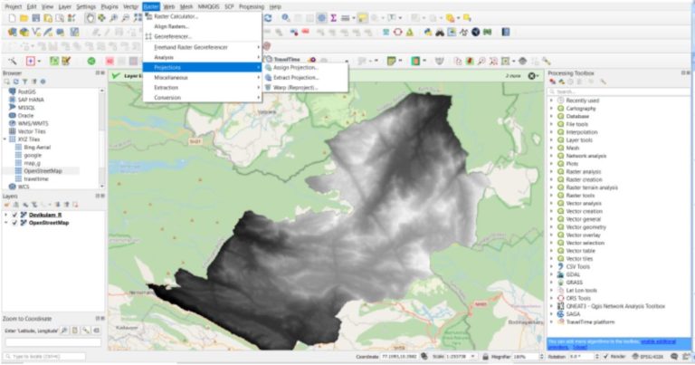
The article represents the method I have used to generate a stream network in a high altitude region in Kerala. The stream network of Devikulam in Munnar is the selected study area and stream and basin is generated using some tools available in QGIS. I am using SRTM DEM with a 30m resolution clipped to the study area and a set of SAGA tools available.

The steps are as follows:

  1. Load the DEM and reproject using the Warp/reprojection tool

The first step is to clip and reproject a DEM into a projected coordinate system. Screenshot Use the option, Raster > Project > Warp/Reproject

Select the required Projected coordinate system with reference to the study area.

  1. Fill Sinks in the reprojected DEM

This step is done to correct any unusual distortions of the DEM and to obtain a continuous hydrological network.

See full entry

Location: Devikulam, Idukki, Kerala, 685613, India

Moin!

vor einigen Tagen hatte ich einen Link gepostet leider mit Fehler.

Damit dieser nochmal “in Vordergrund geholt wird” hier nochmal

https://lvermkv.maps.arcgis.com/apps/webappviewer/index.html?id=da78a306408441769ff803ec349789bc

Hinweis: Daten sind stets vor Ort zu prüfen, da unbekannt wie aktuell diese noch sind.

Jan

Posted by imagico on 20 August 2021 in German (Deutsch). Last updated on 21 August 2021.

Machine translation in English by deepl.com can be found below, should not be read under the assumption of semantic equivalence though.

Die OpenStreetMap Foundation OSMF hat vor kurzem angefangen, Ihre Pläne und Ideen zur Verhaltensregulierung auf Kommunikationskanälen unter Kontrolle der OSMF öffentlich vorzustellen. Und ich habe von mehreren Seiten die Erwartung kommuniziert bekommen, dass ich dazu Stellung nehme - vor dem Hintergrund, dass ich zu dem Thema Verhaltensregeln in OpenStreetMap sowohl ganz grundsätzlich als auch zu konkreten Ideen und den diesen zugrunde liegenden philosophischen Konzepten und Wertvorstellungen schon einiges geschrieben habe.

Ich tue dies hier wie bereits zuvor in meiner Muttersprache, insbesondere um klarzustellen, dass englischen Muttersprachlern zu diesem Thema keine Deutungshoheit über die Begriffe und Argumente zusteht. Eine maschinelle Übersetzung auf Englisch ist unten der Einfachheit halber angefügt, diese ist aber ausdrücklich nicht dafür gedacht, unter der Annahme der Bedeutungsgleichheit gelesen zu werden.

See full entry

श्री भगवान विद्यालय, बालमटाकळी, तालुका शेवगांव, जिल्हा अहमदनगर. जि.प. प्रा. शाळा, बालमटाकळी, तालुका शेवगांव, जिल्हा अहमदनगर. कर्मवीर एस. एन. हायस्कूल, न्यू बालाजी नगर, औरंगाबाद. Government Polytechnic Aurangabad. Maharashtra College of Engineering, Nilanga Dist. Latur. Swami Ramanand Teerth Marathwada University, Nanded. Maharashtra State Board Of Secondary and Higher Secondary Education, Pune Divisional Board Aurangaabad. अभिनव चित्रशाला, नांदेड। श्री बालंबिका सांस्कृतिक मंडळ बालमटाकळी ता. शेवगाव. महाराष्ट्र राष्ट्रभाषा सभा पुणे। मराठवाडा विज्ञान विकास मंच, औरंगाबाद. श्री शारदा मंदिर कन्या प्रशाला औरंगाबाद. अमानविश्व विद्यालय, औरंगाबाद. मराठवाडा शिक्षण प्रसारक मंडळ. देवगिरी हायस्कूल औरंगाबाद. वेद विज्ञान अनुसंधान संस्था, शिवपुरी अक्कलकोट. महाराणा प्रताप हायस्कूल औरंगाबाद. जगदंबा शिक्षण प्रसारक मंडळ मंठा. सुधाकरराव नाईक हायस्कूल, औरंगाबाद. भ्रष्टाचार विरोधी जन आंदोलन समिती औरंगाबाद. औरंगाबाद जिल्हा यशवंतराव चव्हाण पुण्यतिथी समिती. कर्मवीर श्री शंकरसिंग नाईक हायस्कूल, औरंगाबाद. Directorate of Employment & Self-Employment. Department of Youth Affairs & Sports. Government of India and State Sports Directorates. INDO GERMAN TOOL ROOM, AURANGABAD. The Institution of Engineers (India). ABHINAV VIDYA MANDIR, BHAYANDAR (E), DIST. THANE, MAHARASHTRA. महाराष्ट्र लोकसेवा आयोग. INDIAN ARMY/NAVY, Selection Centre, Bhopal. INDIAN ARMY Selection Centre, Bangalore. कमला नेहरु शिक्षण संस्था, औरंगाबाद. मेहेरसिंग नाईक विद्यालय व कनिष्ठ महाविद्यालय, औरंगाबाद. श्री रंगदास स्वामी शिक्षण विकास मंडळ, आणे.

At HOT’s ‘all staff meeting’ today, we held live finals of the 2021 HOT Staff OSM FIGHT Heavyweight Championship!

2021 HOT Staff OSM FIGHT Heavyweight Championship poster

For those that don’t know, OSM Fight is a website that allows two OSM mappers to compete against each other based on a number of different metrics.

We had started a few weeks ago with team ‘group stages’ and then entered a knock out competition phase. Only the semi-final and final were left to play…

See full entry

У ОСМ в России большая проблема с деревнями. Деревни есть, а домов нет. Раньше были проблемы с космоснимками, а сейчас с этим проблем нет.

В общем озадачился, начал потихоньку обрисовывать дома и столкнулся с некоторыми неудобствами. Визуально искать неотрисованные деревни сложно и велик шанс пропустить их.

Поэтому нужно было создать квест на MapRoulette, чтоб можно было последовательно обрисовывать деревни, а данные можно загрузить с помощью Overpass.

Пришло время осваивать Overpass

В ходе изучения была найдена старая тема на форуме “Overpass API - примеры запросов”. Собственно там и был найден и немного модифицирован подходящий запрос.

Для эксперимента был выбран Хиславичский район Смоленской области. Из-за большой нагрузки приходится ограничиваться областью района.

area
  ["boundary"="administrative"]
  ["name"="Хиславичский район"]
->.b;

(
  node(area.b)
  	["place"~"hamlet|village|locality"];
)->.c;

(
  way[building](around.c:500)->.build;
) -> .build;

(
  node(around.build:100)
  	["place"~"hamlet|village|locality"];
) -> .d;

(.c; - .d;)->.result;

.result out center;

Что делает данный запрос?

Выбираем район и сохраняем в переменную b:

area
  ["boundary"="administrative"]
  ["name"="Хиславичский район"]
->.b;

Далее ищем деревни в этой области. Значением locality отмечаются заброшенные деревни, решил тоже выделить чтоб перепроверить.

(
  node(area.b)
  	["place"~"hamlet|village|locality"];
)->.c;

Ищу деревни в которых есть обрисованные здания в радиусе 500 метров. К сожалению я не понял как с помощью Overpass написать запрос где наоборот нет зданий.

(
  way[building](around.c:500)->.build;
) -> .build;

У меня есть набор зданий, но я не знаю как мне найти точку населенного пункта. Придётся делать схожий запрос, но теперь ищем точку НП в радиусе 100 метров от здания и сохраняем в переменную d. 100 метров будут гарантировать что точка деревни точно относится к зданию, а не к ближайшей деревне.

See full entry