Posted by bkil on 6 July 2021 in Hungarian (Magyar).

-
A közvetítés a megszokottól eltérő helyen lesz, további információk a Wiki oldalon lesznek olvashatók:

 OpenStreetMap
A közvetítés a megszokottól eltérő helyen lesz, további információk a Wiki oldalon lesznek olvashatók:
Things I’ve done recently:
約1年半前のものまでしか反映されていないらしいが、マップの見た目がようやく更新された。
当時編集をしていた人でこのゲームをもう辞めてしまった人も多いだろう。
あの頃は不便ではあったけど楽しかったな。贅沢な悩みだ。勝手に懐かしさに浸ってしまった。
マップもEXも更新されたので、当初の目的は完全に達したことになる。
とは言うものの、やるべきことは今後も変わらない。
頻度は落ちるだろうが、ポケスト申請とマップ更新は今後も継続していきたい。
This diary post is a follow up on the one I did last week here where I was looking at how much, and for what the Ireland OpenStreetMap community uses the StreetComplete(SC) app.
The StreetComplete creator Tobias replied showing an interesting worldwide trend for SC usage. The trend here shows that there has been an upturn in SC usage worldwide in the last couple of years in terms of the users and edits contributed:
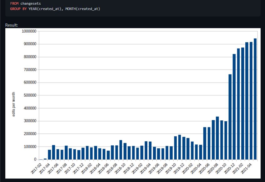
In particular Tobias shows that co-incidental with the Covid-19 months that there was a big upturn in the changesets contributed, starting gradually in May 2020 with a doubling on the previous month, but continuing to rise until the changesets remained at about 4 times the normal level for the forthcoming year. Most users are in the Northern hemisphere, so to see the higher level of changesets sustained through the Northern Hemisphere’s winter months is impressive.
In Ireland the changes, as in the big upturn are also reflected in a little bit of analysis done here.
I’ve just reached my first OSM milestone by confirming all my contact addresses are in OSM. This took considerably longer than expected. I wanted to add the addresses of all my contacts from around the world to OSM so that those addresses will appear in the next map update for the Magic Earth app.
My first step for this milestone was to cull my contacts list for the first time in 20 years. This step took several hours. My next step was to add the addresses of my contacts to OSM if they did not already exist. This step proved to be a very time consuming and frustrating experience, although there were plenty of learnings too.
The first learning which came quite early on was that when postcodes are introduced to a country, parts of the old address are incorrectly removed by the postal service. In one example, my brother was given a new suburb. Unfortunately, people have a tendency to retain the old address and just add the new post code, rather than using the new address in full.
Needless to say people giving out the wrong addresses like my brother makes life difficult for address search engines. A good address search engine needs to be very clever in accommodating this human behaviour. I found the OSM search engine wasn’t very forgiving, while Google search engine was too forgiving at times by giving me the wrong location.
I decided to edit the addresses of my contacts so that the OSM search engine would find the correct location. I didn’t mind changing the address when it was clear that part of the address was wrong like with my brother.
It was obvious to me that Google tries different permutations of the address to find a result, while OSM expects the address to be perfect. I imagine Google’s first permutation in the UK would be to use the post code and street address as that is all that is needed for a location in the UK. If that permutation failed it would try other permutations with the full address until it got a result.
There are multiple mapping tasks in OpenStreetMap that people still have to do old-style, like we did in 2010. But with current technology and with current funding of OSM research, these can be automated, improving mapping quality over the world.
If you work on OSM-related projects for a company, like in Facebook or Apple, please ask your manager if they can spare your time on projects useful for the community. For example:
Imagery alignment! People from the US and Western Europe won’t understand, but in most parts of the world, imagery is offset up to hundreds of meters. Mappers need to shift it to start mapping, otherwise different people would map with different offsets.
We have plugins for automatically tracing roads, buildings and rivers. Why not create a button for JOSM and iD that looks at GPS traces (rasterized or not) and finds the best offset for an imagery layer?
okay I had just that one idea and struggle to come up with more
please share your ideas in comments
Firms like Apple, Facebook and Amazon are paying (their own) mappers for OpenStreetMap (OSM) edits. You are an OSM editor making the same type of work the paid editors are. Shouldn’t you be paid for your edits too? Let’s start sending these firms a collective invoice for our work and use the received funds to benefit the OSM ecosystem. There is an easy way to join if you use JOSM, but users of other map editors can participate as well.
The OSM project is governed by a license that allows its geo data to be freely used by anybody, including the most wealthy global corporations. Regardless, firms like Apple, Facebook or Amazon are paying for improving the OSM data. They do so mainly by hiring mappers, but also by directly sending money to the OSM foundation, albeit with grants that seem rather small in comparison to market capitalization of these firms. These developments - while good for improving the OSM data, raise also some issues. One concerns fairness: if the firms pay their employees/contractors for map edits, shouldn’t they pay to all who make the same kinds of edits? After all, the edits they provide are not special in any respect - volunteer editors have been supplying such data to the OSM database for years. A more subtle issue is, that emergence of paid map editors dramatically changes character of the project, which for most of its existence has been a purely volunteer affair. Increasingly, volunteer mappers can no longer point to “the Map” and say - we, volunteers did this. Others raised this issue as a problem, but no way out of it has been suggested so far.
As I’m not yet sure what will be included in the alpha version of the damn project, I’m getting inspired. This time by Tanga Building Footprints Import announced on the imports mailing list.
It looks like the buildings are already imported in the Tanga city, e.g. this one, but I’ve never done the import thing, so I can’t say.
In this diary, I’m going to introduce the example mapping workflow with the prepared data based on Tanga Building Footptrints Import using the damn project. Not everything is yet fully automated, so this diary is more like describing the proof of concept. However, I’m open to the needs of the future.
There is the dataset of the buildings available on the wiki page. I like
that idea of huge GeoJSON file that includes the features with the corresponding
geometries. As I’m not the import guy, I’m confused with _key_s in the
properties (I mean these underscores of each key.) I need only building:yes
tag, so I’ve renamed just those (note that notepad’s “Replace All” would do the
same:)
sed -i 's/_building_/building/' buildings.geojson
I’ll create new area to work on. Therefore, I need the geometry of the whole
area, where the buildings are. For that, I’ll use the damn-client.py
scripts. (The shapely must be installed.)
cd damn-client.py
./convex_hull.py buildings.geojson > ch-buildings.geojson
The command took about a minute on my laptop. The ch-buildings.geojson can be
used as the GeoJSON boundary file in the damn project’s manager.
So I’ve area to work on divided to squares. Now, I need the GeoJSON files containing all the buildings of each square. I’ll use the damn-client.py scripts once again:
cd damn-client.py
./prepare_tmp.py https://server.damn-project.org 2351 buildings.geojson
بازهم تشکر
Chicha
Albany marine base. .. Albany marine base
StreetComplete was designed by Tobias Zwick and launched in 2016 as a handy “low-bar entry” field capturing application for OpenStreetMap. In the following 2-3 years it rapidly rose to have a share of 3.9% of contributors favoured application, since it requires no real prior expertise in OpenStreetMap. The beauty of it is that it exploits the opportunity of a mapper being in situ where some features have been mapped, but lack details about their attributes, and tags on the OpenStreetMap database.
The UX is good, even for the experienced mapper it masterfully detects the absence {not to jump down a rabbit hole, but very like my favourite Pink Floyd Album } of tagging details, and then it supports the insertion of the correct tags with menu systems that are visual rather than everything being list driven. Perfect for being on the move, a car passenger or a leisurely walker. This is not supposed to be a review of the app, but you can probably detect that I am a fan.
With some help from my friend Amanda who downloaded the .pbf, and extracted all the editor traces of StreetComplete here I was able to get hold of a csv of all of the Ireland edits and then use that to make a heatmap, with some help from RustyB. The heatmap shows, what we would expect, greater use of the app in Ireland’s cities and large towns.
Working on an upgrade of OpenSnowMap.org map style, I knew I had to add single trees mapped natural=tree, natural=tree_row and barrier=hedge. I figured out I had omitted them in my rendering when I was about to map some … that were already there.
When testing the new style, it comes out as a nice surprise that in some areas, countryside micro-mapping is really impressive :
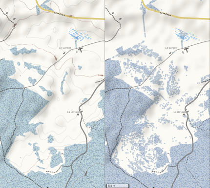
Clearly, rendering all those trees gives a far better idea how the landscape look like there.
I expect that this new style will come live within a few weeks.
Paglat a place that is rich in biodiversity and culture. If you will try to search Paglat in google maps, you will be mislead by wrong information about the place location. You will find it’s location inside another Municipality. Apparently Apple Maps was accurate about Paglat’s map and geotag location. Yes interesting indeed about google maps location of Paglat.
Established and created in 2001, under the Muslim Mindanao Authority Act No. 12 otherwise known as the Regional Law creating the Municipality of Paglat on July 9, 2001, which was ratified by its constituents during the September 29, 2001 plebiscite.
The mother municipality of Paglat was General Salipada K. Pendatun (GSKP) or to simplify it Paglat was a Barangay curved from GSKP.
Paglat’s boundaries or adjacent Municipalities are President Quirino province of Sultan Kudarat, Pandag province of Maguinanao, Tulunan province of North Cotabato, General Salipada K. Pendatun province of Maguindanao.
For me personally, the pleasure of mapping is not only in the process itself, i.e. arises during mapping, but a substantial part of it comes from the thought of being able to help other people. Let us all make the world a better and happier place through mapping!
The amount of segments used to represent a curved feature is based on assumptions. For example, an editor may interpret a mapper’s input by merging points that are too close together. Many aspects of the editing process depend on the drawing of curves, and many parameters are assumed by an editor.
A drag is a gesture well suited to mapping curves. Instead of lifting from a trackpad - an event which can throw the mapper’s precision off - the mapper drags along the feature’s centerline. Such a mode provides more consistent levels of mapping detail, a speedup in which a mapper can trace features, and a more natural feel to mapping. However, it requires more assumptions by the editor used.
In order to draw a line, one may drag from a way. The same gesture may move the map using merely a capacitive touch. I wonder what the current state of dragging is in all of the editors. Does a feature lack curves because it is closer to an urban grid or because it is tedious and/or arbitrary to map.
Changset ID # 107053042
Cork County Council in conjunction with TII (Ireland’s authority for major roads) are in the process of building a bypass past Macroom and Ballyvourney in Co. Cork, Ireland.
Recently, I was travelling back from Killarney and noted that the road had been re-aligned. I quickly captured some GPD traces and have now updated OpenStreetMap with the new roundabout and re-aligned N22 (the bypass will assume the N22 name I presume when it opens).
This was a relatively nice edit to undertake. While I only had one trace to work with, it was good enough to get a rough idea of what needed to change. I also had to amend the N22 route relation(s) - there were two; one in each direction. I didn’t have a whole lot of experience editing these types of relations but the josm interface was intuitive.
As always, I wanted to validate my work (especially as I was editing a primary national route in Ireland). ra.osmsurround.org is a great tool for that so I checked both relations for issues (see relations 3147725 and 558006).
I expect more changes in the coming months as work progresses on this road.
Finally, I checked to see if other map providers had picked up on the change. Funnily enough it appears that Google have picked up on it (possibly using data from Google Maps’ users) but in much lower detail. I guess their algorithms detect something is up but don’t know how to deal with it properly yet. 1-0 to OpenStreetMap!
p.s. Driving round the roundabout 3-4 times was quite fun and a great way to get a good trace for it.
Lange Zeit war mir Mapillary eine wertvolle Unterstützung beim Taggen. Seit einigen Monaten nicht mehr. Mapillary entwickelt sich offenbar in eine Richtung, die meinem - zugegebenermaßen speziellen - Workflow keinen Raum mehr gibt.
Wenn ich draußen unterwegs bin, ist mein Garmin Oregon 650 immer dabei. Videos erstelle ich keine, besondere Situationen halte ich mit Fotos fest. Im Regelfall sind meine Sequenzen kurz: ein Überblicksfoto zur räumlichen Orientierung und einige wenige Detailfotos. Häufige Motive sind Wegweiser, E-Ladestationen, Gebäudedetails u.a.m.
Vor jedem Hochladen prüfe ich die Fotos auf (i) Blickrichtung (ii) die absolute Lage und (iii) die relative Lage zueinander und korrigiere sie gegebenenfalls. Die meisten Fotos benötige ich gar nicht auf Mapillary. Zum Taggen kann ich die Fotos genau so gut in JOSM direkt laden und verwenden.
Nur in Fällen, wo mir das vollständige Taggen zu schwierig oder zu aufwendig ist, füge ich dem Objekt gerne einen Mapillary Link zum Foto hinzu. Das ist der einzige Grund für mich Mapillary zu verwenden und das wurde immer schwieriger. Die Chronologie:


