“OSM Latest Changes” (https://rene78.github.io/latest-changes/) just got a few updates to make exploring recent edits more insightful - and smoother!
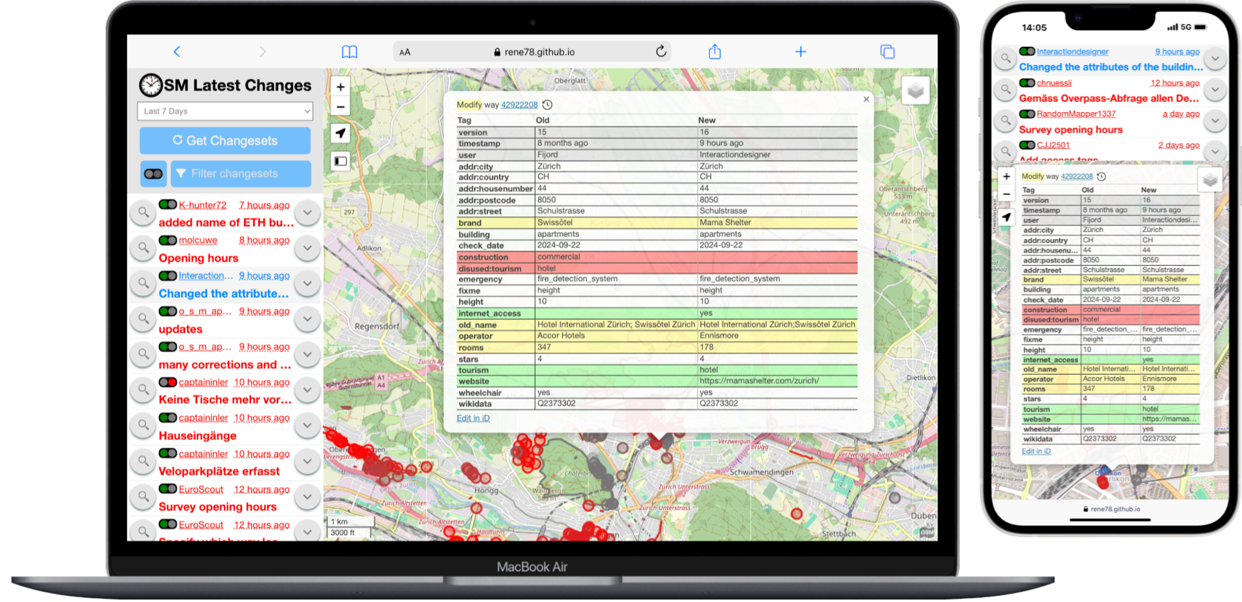
“OSM Latest Changes” (https://rene78.github.io/latest-changes/) just got a few updates to make exploring recent edits more insightful - and smoother!
Sur la Via Ardèche, soit c’est de l’asphalte (du goudron noir ou gris clair), soit c’est du “Compactée” comme on peut le voir là : osm.wiki/Tag:surface%3Dcompacted
Woah, I didn’t realize how quickly this would be something I’d like. I know my account has been around since 2022, but I seriously started mapping in mid-2025. ~10k Edits pretty quickly, and turns out I enjoy editing the map. Maybe I’m looking for a job around this kind of work… Who knows.
Automated License Plate Readers… Man these things are poping up everywhere. I stumbled on Deflock.me recently. I don’t agree with their “Why” but, I don’t agree these things are good for society… I get that we don’t have a “right to privacy” in public spaces, but man…. this seems one flew over the coo koo’s nest. Is pervasive surveillance at this scale really that surprising? My county alone has 95 ALPR’s (mostly by flock) running 24/7/365 rain snow or shine…. That’s 1 camera per 22 sq.mi. or 1 camera per 7700 people.
Its not right…
95 Cameras over 2130 square miles, and estimated 730,000 people.
Deze route met metalen sculpturen is al uitgezet, maar de sculpturen zelf waren nog niet gemarkeerd en benoemd. Tijdens een wandeling heen en terug heb ik de route e n de scultpuren met mijn Garmin GPS 64s getrackt.
In de middag deze data maar eens ingevoerd.
Cústame escribir isto pero teño a necesidade de facelo. Vou parar un tempo (non sei se definitivo) porque estou sufrindo unha certa obsesión con OSM, absorbéndome moitísimo tempo e esforzo e creo que comezo a ter algúns problemas psicolóxicos ou de conduta. Ata soño polas noites co mapa. Tamén me decatei que cando alguén cambia as miñas edicións dun xeito errado sufro unha leve ansiedade e ata aquí cheguei. Non quero enfermar.
Un saúdo á comunidade galega e berciana e moita forza.
Edito: Ao final volvo coma un parvo coma sempre…
Aggiornamento alla voce del diario dello scorso anno con gli ultimi estratti di Geofabrik. Ecco una lista aggiornata al 20 luglio 2025 degli utenti che hanno mappato sul suolo italiano per almeno 90 giorni consecutivi:
.
X042、X188过境
Y039珲阿线-南山头✓
市域无县道
Y010桃园-太阳
Update from November 6th: All the bulletins effectuating the Type A/B changes from 150 mph to 160 mph are in my possession. I upload employee timetables and bulletins here. I also now request bulletins every month from Amtrak.
I learned a bit about supplemental bulletin orders and summary bulletin orders and the schedule on which they’re issued. Summary bulletin orders are issued every first Monday of the month (and split by line such as NYW and BNY) and supplemental bulletin orders are issued as needed. The monthly summary bulletin orders always contain the aggregation of changes since the previous employee timetable so they can be further used to find the original supplemental bulletin orders that effectuated specific changes. Full employee timetable publications may take place of the monthly summary bulletins.
Modified on July 14th, 2025 by Supplemental Bulletin Order NYW1-18-c:
Modified on July 14th, 2025 by Supplemental Bulletin Order BNY1-18-a:
Rhode Island #1: MP 154.3 & MP 171.7, except Cv MP 159.7 & MP 160.5 and Cv MP 170.5 & MP 170.9
Massachusetts: MP 194.5 & MP 205
Modified on September 1st, 2025 by Summary Bulletin Order BNY1-20SUM:
There is no Type A train that can exceed 150 mph because the NextGen Acela is still Type B. The maximum speed possible in the Rhode Island #2 section remains 150 mph because the Type B speed is still 125 mph.
Update from August 29th: I’ve upgraded the speeds back to 160. What a crazy exercise of futility. One day later I also obtained summary bulletin order describing most of the changes. There’s still a little more work to do.
Welcome to my diary, “Where did I macro-mapped” This will be available in English and not Italian cuz: 1. I need to speak better english 2. I will (not now but not far away) wanna macro-mapping in the USA (i heard that they have absolute good imagery!) 3. Wanna move from Italy and go to Wisconsin, USA. — Where did I micro-mapped? I micro-mapped Tre Ponti Est (service plaza/rest area/or whatever you call it) look it in 3d, look it in 2d changeset I also micro-mapped the nearby service plaza/rest area, Tre Ponti OVEST, look it in 3d, look it in 2d, changeset 1, changeset 2 — (If you are looking from when I published. UTC+2 02/08/2025 23:30 or Wisconsin Time 02/08/2025 16:30, The Tre Ponti Ovest is not available cuz of cooldown aka [waiting server](https://en.wiktionary.org/wiki/waiting#:~:text=waiting%20(countable,%2C%20service.)
“You’ve been involved with OpenStreetMap for at least 15 years,” the interviewers begin, marking the start of the session.
I gasp a little. Wow—15 years? Imagine all the… fights and drama?
So I get a little curious and start tracing this person’s digital footprints across the whole OSM universe. See if I can learn a thing or two.
“Upgraded road 11390 to secondary to make it stand out from all the other roads.. Because it has bus routes and stands out for transit traffic.”
“This reasoning sounds quite arbitrary to me. Also what degree of transit traffic is necessary so that the road has to ‘stand out’? General convention followed elsewhere outside of cities – and as currently documented – is to use this tag of this type and that tag for that type. The way this road stands out is now inconsistent to how other roads of these types stands out. I think it should be restored.”
“Hmm. That is a fun rule that’s easy to implement and validate. But what are you expecting to achieve with it, other than theoretical correctness – which in cartography is useless, as you might have experienced? I made it secondary, because of its heightened importance to transit traffic. So that routing engines prefer it when routing to there and not fall back on local roads. And even visual inspection would send people on it. So what would be the intention on changing it back?”
“The main benefit of mapping it to certain official classification is that this way we have a clear criteria. This official classification after all also generally indicates which roads are actually more important. If we tied tagging values to official traffic density data then probably it’d be considerably more difficult and likely the result wouldn’t be as intuitive for end users. I find that this way it’s rather difficult to decide on which highway value each road should get.”
The conversation abruptly stopped right there.
Disclaimer: This is just the start of a diary article, details about mapping objectives, progress and obstacles/questions will follow
The Ndomba Sector (Collectivé de Ndomba) is the easternmost sector of the Kabeya-Kamuanga Territory. While the eastern and southern borders of the sector are as well the borders of the territory (which have already been mapped for years), the western border of the sector is the River Lubi.
This sector is still very remote, despite of the fact that the big City of Mbuji-Mayi and the highway Route National 1 (RN1) are close by in the south-east and south. The main reason for the remoteness is that a number of meandering rivers hinder or limit the asccess from almost all directions. The main access road from the south and from Mbuji-Mayi has been the one which leaves RN1 at 6° 06 28.3 N / 23° 26 03`` E just west of the village of Tschibombo - only 20 kilometers west of Mbuji-Mayi. This road follows the border of the watersheds of the river Mulenda (east) and of the rivers Lubi and Kagangayi (west). This way the crossing of rivers and streams is avoided for most of the distance.
I’m excited to share the midterm progress on my Google Summer of Code 2025 project: Temporary Road Closures Database and API for OpenStreetMap. This project aims to create a centralized platform where users can submit and retrieve real-time information about temporary road closures, enabling OSM-based navigation apps to provide better routing around construction, accidents, and other events.
I’m thrilled to announce that I’ve successfully passed the midterm evaluation! The project is progressing well and is currently on schedule with several components ahead of the original timeline.
京杭运河镇江段是重要的航运水道,桥梁多为大型公路桥或铁路桥,跨越宽阔的水面。主要桥梁自西向东(大致方向)包括:
高资河桥/高资桥: 位于丹徒区高资街道附近。
润扬大桥(公路桥): 虽然不是直接横跨运河主航道,但其南汊桥(悬索桥)跨越长江,其引桥和接线工程会跨越或邻近运河相关水道(如运粮河等),是区域重要通道。
镇江西高速桥: 沪蓉高速(G42)跨越运河的桥梁。
镇江西互通连接线桥: 连接镇江市区与高速公路的桥梁。
戴家门桥/润兴路大桥: 位于润州区,是市区西部跨越运河的重要通道(S243省道)。
檀山路桥: 连接镇江主城区与丹徒新区的主干道檀山路跨越运河的桥梁。
九华山路桥: 九华山路跨越运河的桥梁。
官塘桥: 位于官塘桥路,是市区南部跨越运河的重要通道。
沪宁城际铁路桥/京沪高铁桥: 高速铁路专用桥梁。
沪宁铁路桥: 京沪铁路(老线)跨越运河的桥梁。
丁卯桥路桥: 丁卯桥路(金港大道市区段)跨越运河的桥梁,是连接镇江主城区与丁卯、大港的重要通道。
谏壁公路桥/越河街桥: 位于谏壁镇,连接越河街,靠近谏壁船闸。
谏壁闸桥: 位于著名的谏壁船闸枢纽处,通常指船闸交通桥或附近跨越节制闸的桥梁,是连接运河两岸的关键节点。非常重要。
雩山桥: 位于丹阳市访仙镇附近(雩山脚下)。
陵口大桥: 位于丹阳市陵口镇,是跨越运河的公路桥。
二、 镇江市区古运河上的主要桥梁 古运河从平政桥(京口闸)进入市区,向东南流经市区,在谏壁汇入大运河主航道。这段河道较窄,桥梁密集且更具历史人文气息。主要桥梁自北向南(入江口到东南方向)包括:
平政桥: 位于古运河入江口(京口闸遗址附近),历史悠久,是古运河的起点标志之一。
新西门桥: 连接新西门内外。
中山桥: 市中心重要桥梁,连接大西路和中山路。
解放桥: 位于解放路上,靠近伯先公园。
虎踞桥: 历史悠久的古桥(现为复建),位于南门大街北端。
南水桥: 位于正东路西端。
珍珠桥: 跨越珍珠路。
塔山桥: 位于塔山路。
丁卯桥: 古桥名,现为区域地名(丁卯片区),该处古运河上有现代桥梁(如丁卯桥路桥跨越的是主运河,非此段古运河)。
谷阳桥: 位于谷阳路上。
丹徒闸桥: 位于古运河汇入谏壁大运河主航道之前的节制闸(丹徒闸)上。
需要注意的关键点 区分主运河与古运河: 京杭大运河镇江段(主航道)宽阔,是国家级航道,桥梁高大、跨度大、数量相对少些(主要是干线公路、铁路桥)。市区古运河是历史河道,穿城而过,河道窄,桥梁密集,多为城市道路桥,更具生活气息和历史感。
数量众多: 以上列出的是主要的、知名的桥梁。实际数量更多,尤其在城市支路和古运河段还会有不少小桥。
名称变化与具体位置: 部分桥梁可能有俗称或历史名称,具体位置描述可能随城市发展略有变化。高速公路桥、铁路桥通常没有特别的名字,常以线路名称指代。
谏壁枢纽: 谏壁船闸和谏壁闸桥是京杭大运河上的关键节点,非常重要。
动态变化: 随着城市建设和交通发展,新的桥梁可能会建设,旧的桥梁可能会改造或更名。
Date: 28 March 2024
Title: Planning & Co-Creation Workshop on Mapping Road Network of Karnali
Venue: Care Nepal, Sanepa
Organizer: Open Mapping Hub Asia Pacific
Led By: Rabi Shrestha, Sr. Field Mapping Expert & Prajwal Sharma, Jr. Field Mapping Expert
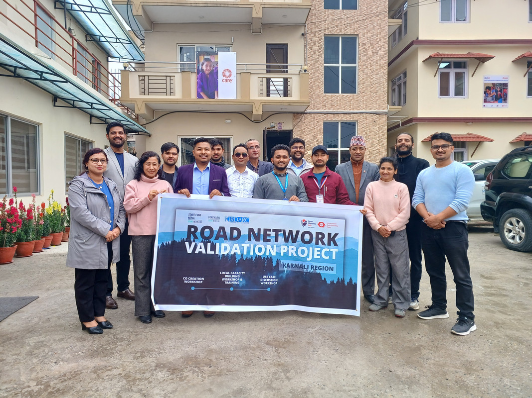
The rugged terrain of Nepal’s Karnali Province tells a story of resilience, isolation, and untapped potential. As the only province where road access remains severely limited—particularly in districts like Jumla—the need for a comprehensive and accurate road network is more urgent than ever. With this in mind, a collaborative Planning and Co-Creation Workshop was conducted to collectively address the challenges, gaps, and opportunities for mapping the road network of Karnali through open-source tools and community engagement.
Ich hab selber recht umfangreiche Notizen über Obstbäume und arbeite aktuell daran die halbautomatisch mit OSM abzugleichen.
Ich habe mir dafür auch einen Spezialisierten Editor geschrieben: “Treewarden”.
The Nominatim QA tool added a new layer “Suspicious addr:state value”
https://nominatim.org/qa/#map=3.52/34.84/5.81&layer=addr_state_not_country
The layer is updated every day.
Give it a go. But not USA and Canada because I was too eager and made many edits today already.
‘ve found myself drawn to a particular challenge: properly mapping the Rhondda Valleys in South Wales. It’s a task that’s proving both fascinating and frustrating in equal measure, but one that’s teaching me invaluable lessons about the complexities of local geography.
My approach has been quite straightforward - I’ve chosen to focus primarily on Ystrad, the area I know most intimately. This isn’t just because it’s familiar territory, but because understanding one place thoroughly seems like the best foundation for expanding outwards. Every quirk I discover, every mapping technique I develop, and every local peculiarity I uncover in Ystrad becomes a tool I can apply to neighbouring areas.
One of the most surprising aspects of this mapping project has been discovering just how much the “official” maps get wrong. I’ve taken to photographing street name signs and house numbers wherever I go - a habit that’s revealed some genuinely baffling discrepancies between reality and what appears on both Ordnance Survey maps and Google Maps.
The most striking example I’ve encountered is Bryn Terrace in Ystrad. This is a very real street, with real houses, real residents, and real post delivered daily. Yet somehow, it’s completely absent from both OS and Google mapping data. Walking down it, photographing the street sign, and checking my GPS coordinates left me questioning whether I was experiencing some sort of cartographic twilight zone. How does an entire street simply not exist in the digital world when it’s so clearly part of the physical one?
The house numbering systems throughout the Rhondda have provided another source of bewilderment. What might seem like straightforward sequential numbering often reveals itself to be anything but. Streets that appear to follow odd/even patterns suddenly throw in a completely out-of-sequence number, or entire ranges seem to have been skipped altogether.
I wanted to share some analysis on a currently undefined part of the PWG Schema (Silver Tier specifically) that I originally posted on the OSM-US Slack. Note that this was discussed previously on the OSM forum, but the analysis here was conducted independently before reading that to.
The key question here: What footway= type, other tags and geometry (separate way from the incoming sidewalk or not) should be specified for the connector ways between the sidewalk centerline and curb nodes?
Currently, the page states only “highway=? + ?=?”; its hard to see how highway= could be anything but highway=footway as nothing else seems more suitable and inventing a new highway type would be a major backward-compat break for little benefit; therefore, the decision then would be what footway=* tag to use.
Surveying the possible options (with pros and cons):


