Users' Diaries

Recent diary entries

Posted by scruss on 11 July 2024 in English. Last updated on 27 May 2025.

There are a couple I walk by every week, both pretty large.

I’ve tagged them natural=beaver_dam ‘cos I found it in some discussion on the wiki somewhere.

Considering so much of Canada is shaped by beaver dams, I think they should get more respect.

(the location for this diary entry is near one of the beaver dams. It was not actually written while near it. If it had been, the beavers would have done their irritated tail-slapping dive to scare me away. It sounds like someone throwing a large rock into deep water.)

Location: Cliffcrest, Scarborough Southwest, Scarborough, Toronto, Golden Horseshoe, Ontario, Canada
Posted by ENGELBERT MODO on 11 July 2024 in English. Last updated on 23 July 2024.

The openstreetmap project is the future of free data for resilience to the many problems of development and humanitarian response that we have in our communities. It gives access to a large database produced by enthusiasts, volunteers and people who believe that development or resilience in the face of the crises we face will require the support of such an initiative.

Someone once told me that to be immortal you have to give without expecting anything in return; support voluntary social actions as best you can,

support the initiative by making a donation of any amount, because at the end of the day it’s the gesture and the intention behind the gesture that counts.

http://supporting.openstreetmap.org/donate

or by having an impact on the management and direction of the Openstreetmap Foundation by becoming a member.

https://supporting.openstreetmap.org/#Membership-Categories

I’ve been a volunteer at openstreetmap since 2022 on 28 April and every day I try not only to help the openstreetmap project grow but also to participate in seeking and proposing solutions that could solve the problems we have in Africa, particularly in my country Cameroon, in nutrition, energy, quality education based on our cultures, water and empowering young people to face the challenges of our society. In short, the planning and development of our country

The last couple of days, I’ve been diving into a very sad chapter of Irish history - “industrial schools” which were children’s homes with less than favourable conditions for some of the children.

It stumbled into that rabbit hole, because a friend who went on a spin with me (I don’t drive myself, but I like being dependent on other people that way, because I always learn something from them that I wouldn’t have, if I drove myself) to look for holy wells had mentioned in passing a boys’ cemetery/ burial ground at St. Patrick’s Industrial School near Kilkenny. This school closed at some point after 1965 and the boys were transferred to St. Joseph’s Industrial School within Kilkenny city. St. Joseph’s had been only for girls until then.

I contacted our heritage officer at the local county council trying to find out whether they knew anything about this cemetery (I’m gonna stick with the OSM terminology from now on), but they had no record of it. It was also not marked on the official maps by Ordnance Survey Ireland (or the historical Ordnance Survey maps conducted by the UK government before Ireland’s independence).

Another friend who knew of the location offered to drive out with me and show me. So we went and I took photographs of all the grave markers (Category on Wikimedia), did a bit of mapillary and mapped the area as best I could (osm.org/way/1298817559) 68 boys and one woman (as I found out later, a matron in her 80s) were recorded as having been buried there. I did a little more research on them which you can read here: https://en.wikipedia.org/wiki/List_of_names_recorded_at_St_Patrick%27s_Industrial_School_Cemetery,_Kilkenny

When we left, my “driver” mentioned that the nuns who ran the establishment (I hesitate to call it a school) also had a cemetery there, but we were pressed for time, so we didn’t visit it that day.

The next day, I cycled out and found the nuns’ cemetery which I also photographed and mapped as a cemetery.

See full entry

Location: Reviewfields, Kilkenny Rural, Kilkenny, County Kilkenny, Leinster, Ireland

Lo studio completo è disponibile su www.academia.edu.

Introduzione

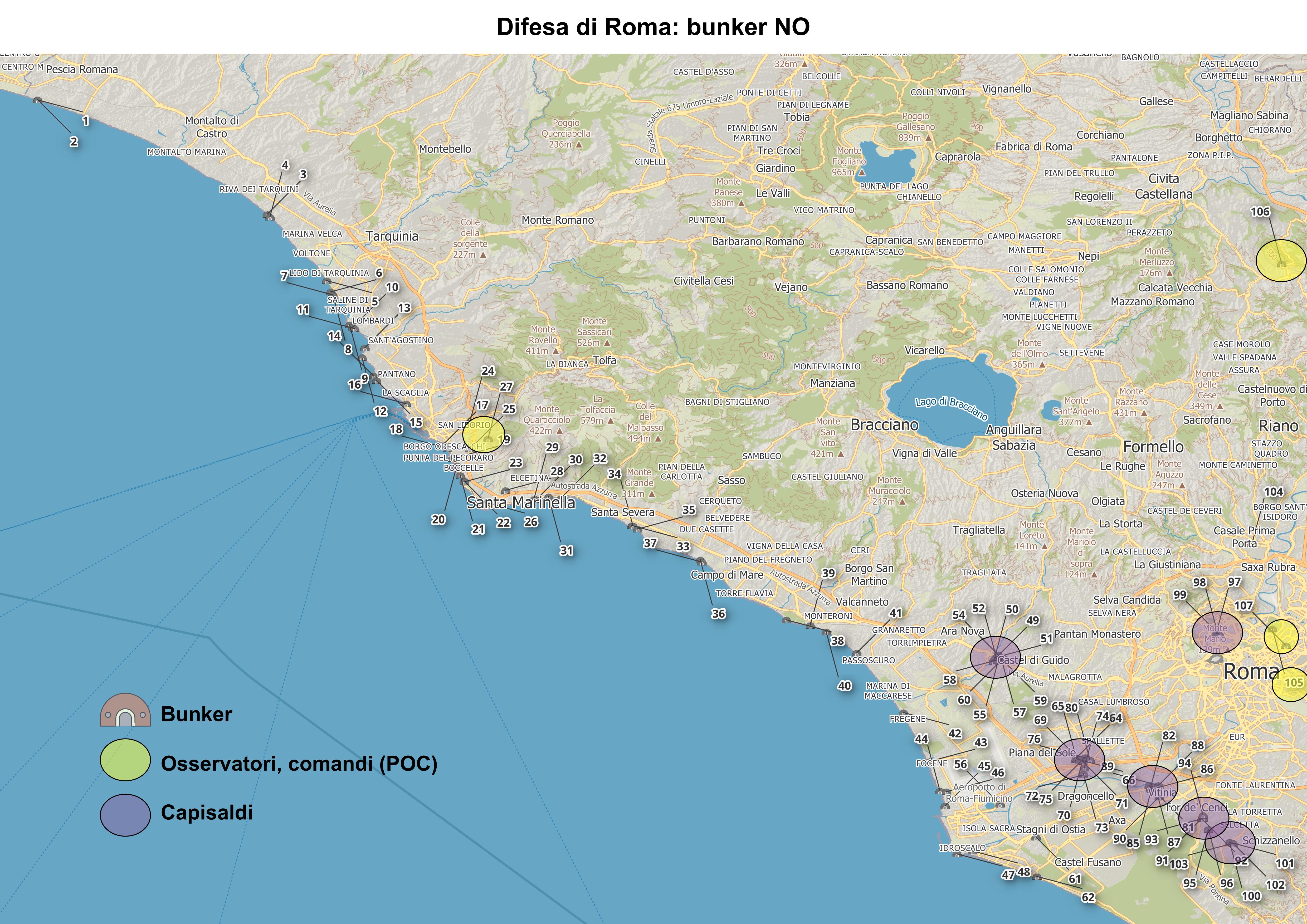
La mappatura è stata costruita mediante l’interpretazione delle immagini satellitari disponibili in JOSM e la documentazione consultabile su Internet riportata nella sitografia e bibliografia. Sono state individuate 108 postazioni militari costruite per la difesa di Roma e per contrastare possibili sbarchi a NO della capitale. Alcune decine di postazioni militari, come i capisaldi di Castel di Guido, Ponte Galeria, Trigoria e Vitinia o i bunker di Villa Torlonia, Ada e Soratte, erano già mappati in OSM altri, in particolare quelli posti lungo la costa tirrenica, sono nuovi.

Figura 1 Mappa dei caposaldi e bunker a NO di Roma. Mappa_caposaldi_bunker Visualizza a schermo intero

Classificazione e risultati

See full entry

Anticipatory action , mapping for landslides and flooding preparedness in the north western provinces of Rwanda

Project Launch with Online Mapping of 50,000 Buildings

The rainy season, from April to June always reminds us that we need to be more than ready, but one would wonder why? We have our brothers and sisters who reside in northern and western provinces who are periodically exposed to the consequences of climate change and experience extreme weather and heavy rain every season. We have resolved to not sit and wait again, so we have decided to take action, Not the heavy one to uplift or relocate every one in high risk but do what we do the best. mapping!
And our story here demonstrates that if we map together, we will overcome the disasters together. especially landslides upstream causing flooding downstream on a periodic frequency. OSM RWANDA April 2024 Mapathon 65

Saturday 27th April 2024 marked the launch of the Anticipatory action.

See full entry

Welcome to the fourteenth OpenStreetMap NextGen development diary.

🔖 You can read other development diaries here:
osm.org/user/NorthCrab/diary/

⭐ This project is open-source — join us today:
https://github.com/openstreetmap-ng/openstreetmap-ng

GitHub Stars

🛈 This initiative is not affiliated with the OpenStreetMap Foundation.

In case you missed it…

Recently, we showcased Search 2.0: a comprehensive overhaul of the search functionality. For the first time, OSM search is now simple and intuitive to use. It’s a must-see (there’s a video demo too)!

OpenStreetMap-NG Repository Moved

This week we have moved the openstreetmap-ng code repository from Zaczero/openstreetmap-ng to openstreetmap-ng/openstreetmap-ng. All stars, forks, and issues have been transferred automatically. All previous URLs are also redirecting to the new address. If you have previously interacted with the project, there’s nothing you need to do.

See full entry

There are a number of places with ♥ and ❤️, and all their variants, in their names. This wiki guidance notwithstanding, I do think it is appropriate because this is the name of the place on signage, but it definitely makes it hard to search for stuff.

Official documents and urls for these locations mostly just use words, like “heart”, in place of the symbol because it is simpler and technically, or legally, required.

These hearts really are only the tip of the iceberg there are thousands of OSM entities with emojis in their names.

I am inclined to leave the emoji in the name tag but use the name:en tag to expand these emoji to words. Or should i just bring these names into “compliance” as the wiki indicates that emojis should be avoided in names.

Any thoughts on this?

Location: Denver, Colorado, United States
Posted by ManuelB701 on 9 July 2024 in English. Last updated on 17 July 2024.

Stuff I hate about sidewalk mapping

I have a certain… love-hate relationship with separte sidewalk mapping. On one hand, they do allow for a more complex mapping like specifying the type of separation between sidewalks and carriageway, easier to specify the surface of sidewalks (especially if the corresponding carriageway is split up), etc. On the other hand, they make routing (potentially) more complex (it’s complicated, actually) which is why I generally see them more useful on busy roads and outside settlements where you don’t expect spontaneous crossings. One thing what really fuels my issues with them, though, is just how careless a lot of users are with them, that one should go and map them however one wants despite the potential problems which can arise.

This is ultimately what I really hate about them: That (typically inexperienced) users go and start mapping sidewalks however they want (that is, draw them as they exist on a map). It’s such a big issue because it actually breaks routing, particularly if you map around blocks which usually only have limited official crossings and in turn a lot of virtual paths have to be created. Some pretty bad ones are such sloppy that they ignore all the warnings in their editor (be it two unconnected but crossing ways, way-building intersections or isolated ways).

All in all, here are my personal faux pas you can make with them (aside from ignoring all the warnings in your editor of choice):

Not detaching ways from the carriageway

This is a classic “just draw sidewalk” phenomenon: Draw the sidewalk but keep the connections from the now carriageway.

See full entry

It seems that I forgot to add a Diary Entry yesterday.

Yesterday I mapped the village Renz and the surrounding areas.

Today I started with Demiraj which was fully mapped (Thanks to DenisJu which has done an amazing job mapping Shkodra and the surroundings) so I moved next on the list.

I mapped the village Slatinjë which was really tiny, so I decided to map also Radesh and Gradec.

“#100villagesin100days #day33 #day34”

I am finding shapes and believing that I have discovered a very important pattern not completely mentioned earlier. Using those principals in those pattern shapes many geoglyphs are appearing over and over. Some are of animals and others of what appears to be humans. Most see to use the natural hillsides and valleys and then some modifications to the terrain to bring out the features with the figures. These are not easy to spot, as I have been trying to spot some for quite a while, only recently appearing of which I can’t unsee.

At some point I’ll make some kind of formal presentation but for now I am continuing to lay shapes down.

Incidentally, I am not using any AI or Google Earth enhancers of any kind. Most shapes are not indicated, and some may be part of a previously discovered shape. If I see shapes over shapes, I’ll try to add a second line type.

For years, I’ve been an active contributor to OpenStreetMap (OSM) – starting as a mapper in college (2017) and evolving into a trainer, leading over 30 trainings and reaching more than 1500 people. Recently, I took my commitment to the next level as a Trainer Fellow with Open Mapping Hub Asia Pacific (OMH AP). This 5-month journey wasn’t just about delivering training; it was about wearing a new hat – that of an organizer.

The Guru fellowship involved five trainings, including three online, one in-person (which I’ll delve into), and one where I acted as a support trainer. While every training experience is unique, this in-person workshop held a special place.

The in-person training titled “Map and Chat: Open Mapping Hands-on Workshop for DRR 2024”, held on April 28-29 2024, was designed for bachelor students with diverse backgrounds in Kathmandu, Nepal, in collaboration with Open Mapping Hub Asia-Pacific, Sendai Stakeholders Children and Youth Group, UN Major Group for Children and Youth (UNMGCY) and ALIN Foundation Nepal. The workshop aimed to equip them with hands-on open mapping tools and knowledge for disaster risk reduction (DRR).

Stepping Up: The Organizer’s Hat

While I was accustomed to crafting training materials and schedules, organizing demanded a whole new set of skills. The in-person aspect brought a new layer of complexity of logistics. Suddenly, I was creating Google Forms, counting water bottles and pens, designing posters and certificates, budgeting and managing finances and also analyzing participants’ backgrounds to tailor content effectively (as I usually do as a trainer. Gone were the days of solely focusing on the curriculum.)

See full entry

Location: Kathmandu-11, Kathmandu Metropolitan City, Kathmandu, Bagamati Province, 44617, Nepal
Posted by valhikes on 8 July 2024 in English. Last updated on 9 July 2024.

About a year ago, I actually encountered a use of highway=road as I aligned roads and added a bit more detail to the area at the south end of Mendocino National Forest. And what is a “road”? A placeholder! “Undefined” is actually quite defined comparatively. I investigated what it should be a placeholder for and found it was marking an ATV trail. It had been there a few years and could survive a few more.

Since JOSM doesn’t even seem to know one might want to set a value called “atv”, perhaps I should explain. Also called a “quad”, these narrow little four wheeled things can’t quite go everywhere a motorcycle can go, but they’ll get a lot more places than a 4x4 vehicle. There were 3 wheeled ones (probably still are in other places) but they were banned because they killed people more often due to rolling more easily. People grumbled at first. Three wheels is more fun! But they seem happy now. It hurts to roll over. Often tagging goes a little like this:

highway=[um]
atv=yes/designated
motorcar=no
maxwidth=1.27

(No side-by-sides, as the signs in Colorado often said! Those are often known as ATV or UTV.)

But is [um] a path or a track?

Well, the wiki on “path” is quite clear: “A highway=path is not for use by four-wheeled (two-track) vehicles.” Then it muddles a little: “A path-like way where four-wheeled vehicles are allowed, is likely better tagged as a highway=track or highway=service.” Only “likely”.

Meanwhile, on the wiki on “track” we find that track is “generally not appropriate” for “A trail or path that is not wide enough for a typical four-wheeled motor vehicle.” There is a footnote to clarify this: “A “typical four-wheeled motor vehicle” means a general purpose or average motor vehicle commonly used in a given region. The size and capability of what is considered a typical, common, or average vehicle varies around the world.”

See full entry

Location: Rice Fork Summer Homes, Lake County, California, United States

Today I started with Llëngë, a village with a population of around 75. After that I moved around in the villages in Pogradec and mapped a little here and there.

I decided to go back to my hometown and I continued mapping the city of Çorovodë, which still needs some work. I will map with EveryDoor when im there next time. Furthermore, I moved further to the village Sharovë, Prishtë, Rehovicë (which is my grandfather’s village) and finally I partially mapped Çepan.

I am sure I have forgotten some villages because today I roamed a lot on the map and I can say this Sunday started very good.

Time to translate a Wikipedia article to Albanian now. Another challenge among some Wikimedia friends.

“#100villagesin100days #day32”

Treinamento teve foco na representação de feições com dados do Censo Demográfico 2022 (Brasil) e da cartografia social realizada no estado

IVIDES.org promoveu uma oficina híbrida sobre mapeamento colaborativo com OpenStreetMap e criação de mapa Web com uMap, para turma de estudantes de geografia da Universidade Federal do Ceará (UFC) e o público em geral.

Na oficina, foram mapeados dados de estabelecimentos educacionais*, de três cidades cearenses - Paracuru, Caucaia e São Gonçalo do Amarante e de cartografia social**, com demonstração da criação de mapa Web com uMap, contendo camadas estáticas e dinâmicas, e com personalização de ícones.

No programa do treinamento, foram abordados: conceitos importantes de mapeamento colaborativo; modelo de dados, editores e aplicativos para dispositivos móveis, download e upload de dados do OSM; e três plugins para QGIS, importantes na criação de mapas estáticos. Além disso, foi mostrado rapidamente como utilizar o editor iD e consultar as etiquetas na Wiki OSM Map Features e no próprio editor.


Os arquivos da oficina e um roteiro para prática estão disponíveis em português, na pasta virtual. O vídeo gravado da sessão pode ser encontrado no canal IVIDES no YouTube

See full entry

Location: Centro, Fortaleza, Ceará, Região Nordeste, Brasil
Posted by GanderPL on 6 July 2024 in English. Last updated on 11 July 2024.

I started working on a helper for OSM because I use several community-made tools, and it’s not very convenient to copy and paste links, nodes, or IDs into these tools. So, I decided to write my own userscript. This script will detect what the user is currently viewing and attach the appropriate links already prepared for the tool.

It’s a very simple script, and anyone can create something like this. However, I plan to use AI to help with tagging in the future. It began with a simple rule I used for tagging points, which made me realize I could automate it more. This will be implemented in the helper.

The helper will use Vue.js to control the interface view. In future I plan to release an extension for Chrome and Firefox.


I would appreciate any suggestions or links to web applications that might be useful.


Current releases

nettoyage de la ligne 702000 (Ligne de Montluçon à Saint-Sulpice-Laurière) : 52 PN normalisés, quelques TVP (traversées des voies pour le public) , points de construction X3. ( 1400->4200 pts pour 112 kms) 5 jours de boulot dépaysants. prochaine cible : ligne 712000 (Ligne de Busseau-sur-Creuse à Ussel) : 51 PN au programme

Embarking on the Osm Guru Fellowship was an exciting and transformative experience. This five-month-long journey focused on mapping track has provided me with a unique opportunity to enhance my skills and knowledge in OpenStreetMap (OSM). Each month presented a new task and challenge, pushing me to explore different tools and techniques within the OSM ecosystem.

The first month introduced us to the basics of OSM. Our task was to map a specific area using the OSM platform. This involved adding and editing features on the map, such as roads and building features. In the second month, we focused on collecting Points of Interest (POIs) using the Every Door app. This tool was new to me, but through hands-on exercises, I became familiar with its features. Our task was to identify and document various POIs in a designated area, such as restaurants, shops, and public facilities. This exercise enhanced my ability to gather and input detailed location data. The third month centered on using Mapillary to collect street-level imagery and POIs. We were tasked with capturing images of streets and integrating them into the OSM database. Additionally, we used the imagery to identify and add POIs. By the fourth month, our task was to create a map using the POIs we have collected before. The final month was dedicated to the validation. We were assigned to validate feature such as buildings and roads.

The Osm Guru Fellowship was a transformative experience. Each month’s task helped me develop a deeper understanding of mapping and OSM tools such as Every Door and Mapillary. I am now confident in my ability to contribute to the OSM community and use these tools effectively. This fellowship has greatly enhanced my skills and appreciation for the importance of accurate and detailed mapping.