What is this why is there a diary
Users' Diaries
Recent diary entries
Hi again,
It’s just 2 days before this diary post was published, and I’m very happy to announce that I will start proposing tags again. I already have exciting ideas and hopefully the community approves them.
EDIT: Next proposal will hopefully come tomorrow or this week, stay tuned!
Ewrt1
Posted by EkMapa on 24 March 2024 in Spanish (Español).

-
Cullera:
· Crear áreas de casas en la urbanización Cullera Park. (+58 edificios) · Crear áreas de casas en la urbanización Bonavista. (+132 edificios) · Crear áreas de edificios en parte Noroeste de la ciudad. (+88 edificios) · Crear áreas de edificios en Cullera centro. (+123 edificios) -
Bilbao:
 · En el parque de Amezola (+ 1 camino)
 · En el parque de Amezola (+ 6 áreas verdes)
Posted by yvonnepaje on 24 March 2024 in English.
Shape my future with OSM Mapping and Youthmappers: Post Graduation Blog
A few months after my graduation, I find myself questioning how prepared I am to face the real world. Will the knowledge I acquired in school, particularly regarding organizational management, truly benefit me? Or could OSM mapping play a pivotal role in shaping my career path?
But how exactly do OSM mapping and YouthMappers influence career decisions?
Through mapping activities, I've gained critical thinking, problem-solving, and collaborative skills—qualities highly sought after in today's job market. Little did I anticipate that within these communities, I would uncover aspects of myself previously concealed. Leadership, once abstract, found a nurturing environment within the supportive ecosystem of YouthMappers. It was here that I discovered my capacity to lead, inspire, and effect change.
YouthMappers became my haven for personal development more than merely a platform. With every mapping project, my confidence increased. Although it was scary at first, public speaking became a skill I developed whenever I got the chance. Our community's response to our influence extended well beyond the boundaries of our maps, creating a lasting impression on people's emotions.
These days, certificates appear on my résumé as credentials as well as proof of my experience. They talk about the hours spent creating, learning, and working together. With the support of mentors and the friendship of other mappers, I learned things that went beyond what was found in textbooks.
Today, I stand not just as a graduate, but as a leader forged in the crucible of YouthMappers. I have the privilege to educate others on utilizing OSM mapping for change. Once reticent, my voice now brims with the fervor of someone who has experienced the potency of unity in action.

Welcome to my second OpenStreetMap NextGen development diary. I am ready to highlight this week’s progress — and there was a lot 👷!
You can subscribe to my diary updates on RSS here:
osm.org/user/NorthCrab/diary/rss
Finished Settings Page
Last week I showcased initial progress on the new settings page for OpenStreetMap. This week, I’ve finished it. Here’s what’s new. Keep in mind that if you believe some features should be done differently, there will be a period of public testing where I’ll collect this kind of feedback 😉.
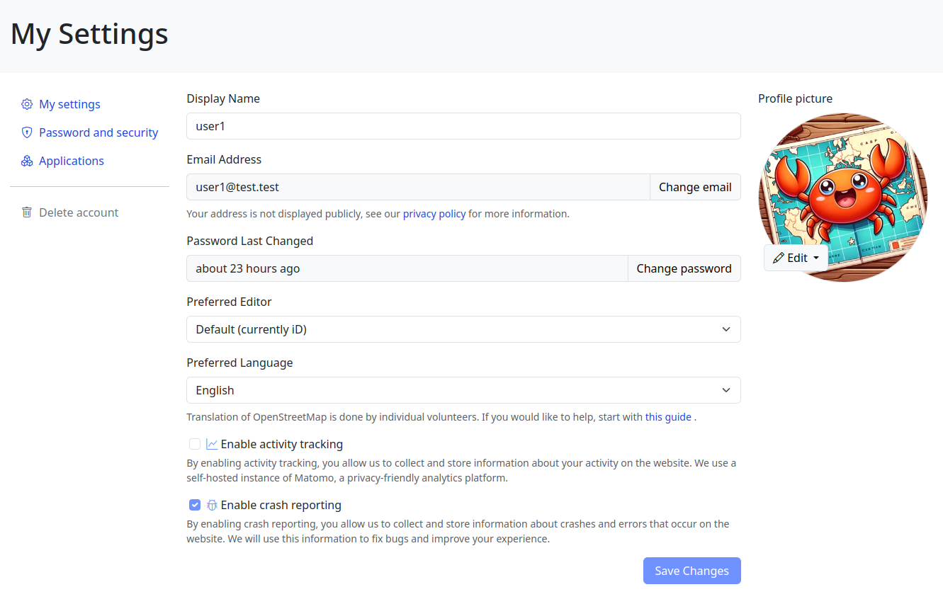
Click here to view it in full screen.
Aside from the improved layout, I’ve introduced two notable changes. First, the application language selection has been redesigned; it’s now a simple dropdown selector. I believe the current system (where you input locale names by hand) is difficult for less technical people to understand, and I want to make the website more accessible to everyone!
Posted by Kanoxitu_zh on 22 March 2024 in Chinese (China) (中文(中国大陆)).
求助,今天补充地图的时候网络卡了,结果回来的时候就变成这样了,右键显示的都是[missing “en.javascripts什么的,重启清理数据也没用,只能换其他游览器,有没有什么别的处理方法。 图:https://ibb.co/S0KVzp8
Posted by sannoization on 22 March 2024 in Russian (Русский).
Last updated on 14 August 2024.
Всем привет, занимаюсь маппингом с февраля, а все началось с поста Андрея Ситника в Мастодоне
Поставил себе streetComplete и понеслась
Что нужно чтобы вкатиться в маппинг с 0
Карты и редактирование
- StreetComplete — Приложение с квестами для OSM. Самый простой способ редактировать данные, пока гуляешь до магазина / работы / парикмахерской, едешь на другой конец города. Также можно записывать GPS-треки. Пока есть только версия для Android, но разработчики уже занимаются версией для iOS
- EveryDoor — альтернатива StreetComplete для iOS и Android. Без квестов, я бы назвал это облегченным вариантом Vespucci, однако его удобно использовать для доработки объектов, добавленных в StreetComplete (т.к. он содержит все теги и значения с OSM) и для проверки уже замапленных объектов.
- OpenStop — приложение для редактирования информации об остановках
- Organic Maps — оффлайн карты от создателей maps.me с возможностью редактирования, в последнем релизе (неделя с 18 по 24 марта 2024 года) в android-версии вернули авторизацию через OSM-аккаунт. В нём можно смотреть отрисовку крыш зданий.
- сам этот сайт, на котором я пишу эту запись в дневнике — редактор iD, ля некоторой advanced-доработки объектов
- OsmAnd — чтобы смотреть разные наложения карт. В нём тоже можно редактировать объекты, но не так удобно, как в StreetComplete.
- OSMTracker — чтобы писать GPS-треки для дальнейшего маппинга дорожек. Пока пишешь трек, можно добавить текстовые заметки, голосовые заметки, фотографии и объекты.
Треки с зеркалами
- Mapilio (для тех кто в РФ) — чтобы создавать зеркала, которые интегрируются с OSM. В РФ очень мало пользователей, в Нижнем Новгороде кроме меня никто треков с зеркалами не писал, в Москве навскидку треков <50. Проект существует недавно, развивается, планируют добавить поддержку панорам с дронов.
- Mapillary, KartaView (для тех кто не в рф) — тоже чтобы создавать зеркала, интегрируются в OSM, из этих сервисов треков с зеркалами больше всего.
Advanced

Participants shaded by umbrellas, to protect them from the sun, while collecting fresh geodata with FieldPapers. UP Mindanao Campus, Davao City. Photo shared by UPMinYouthMappers in their SNS post.
While visiting the family down south, I had a chance to join UP Mindanao’s own chapter, UPMin YouthMappers while their College (of Science & Maths) was celebrating Pi Day. The coordinator asked if I have any preference for the name of the activity we had in mind, and I suggested Map-Pi Day.
Posted by ZekOwney on 21 March 2024 in French (Français).
Last updated on 16 February 2026.

Mars 2024.
Bientôt un an (11 mois) que j’use ma souris sur OSM… Et déformation professionnelle oblige, je reportais déjà quelques stations d’épuration suite aux études réalisées au boulot. Puis j’ai commencé à corriger/compléter via Osmose.
Voyant le Calvados (14) quasiment vide de corrections, j’ai cru que quelqu’un avait déjà fait le taf…
Et bien oui ! Mais très peu d’installations dessinées, juste des emprises. Du coup consultation du jeu de données Sandre pour les installations de traitement des eaux usées.
Il existe un bon millier d’installations normandes sur les 22000 au national. Et la plupart n’existent tout simplement pas dans OSM. Bref, je me lance dans un défi qui va me prendre entre 6 mois et un an (plutôt deux en fait…) d’ajout/habillage/actualisation/complétion sur la seule région Normande.
Mais quelle idée…
Sono Squarcia Claudio, socio CAI della sezione di Ascoli Piceno, Mi occupo di sentieristica
Posted by dcapillae on 19 March 2024 in Spanish (Español).
Last updated on 1 July 2024.

Esta entrada recoge información de interés sobre la clasificación jerárquica de la red viaria metropolitana de Málaga y una propuesta para su etiquetado en OpenStreetMap. Los documentos de referencia para la clasificación de la red viaria metropolitana de Málaga son el Plan General de Ordenación Urbana (PGOU), aprobado en julio de 2011, la Ordenanza de Movilidad de la ciudad, aprobada en enero de 2021, y el Plan de Movilidad Urbana Sostenible (PMUS) de Málaga, aprobado en junio de 2021.
Plan General de Ordenación Urbana
El PGOU, en el Título VII del Documento C (PDF 272.4 kB), establece las siguientes categorías de vías en las que se clasifican las calles de la ciudad:
- Vías de primer orden, aquellas que dan acceso a las vías metropolitanas y comunican barrios de la ciudad entre sí.
- Vías de segundo orden de primera categoría, que conectan las zonas urbanas próximas o permiten el acceso a las vías de primer orden.
- Vías de segundo orden de segunda categoría, el resto de vías importantes de cada barrio o zona urbana, que se convertirán en el eje del barrio.
- Vías de tercer orden, las restantes.

I’ve been kind of bouncing around various projects the past week.
I have tentatively completed sidewalk mapping in Emsworth Borough, and have moved on to adding sidewalks and pedestrian crossings in Avalon. I also did a little revamp of the playground adjacent to the Avalon Elementary School. It turns out that as I was extending the sidewalk along California Avenue, I met up with some previously mapped sidewalk bits, which is nice. Although they have not added a lot of the tags I do, so I will circle back to make this area a little more seamless with what I’ve added to the west.
I’m planning to go through Ben Avon and Emsworth to tag pedestrian crossings and curbs a little more consistently; I had been changing the way I tag things as I went based on new information/methodology.
I got kind of distracted when I realized that Pittsburgh Botanical Garden needed some updating due to their recent renovations. I was able to add the new visitor center and update a lot of the concrete paths, but I have some question marks as to the accuracy of some of the other paths on the property. I will take some good GPX tracks the next time I am there (likely this week). I especially want to see what progress has been made on the feature that is to the southwest of the Lotus Pond. I will also try to acquire a more precise/accurate/official property map from PBG, because the pictoral one on their website is great for ordinary wayfinding, but wholly inadequate in precisely showing where things are.
There’s lots of data stored in OSM about bus stops, but often maps and apps created with OSM data don’t make much use of it (with OsmAnd being the notable exception). For here’s a bus stop as shown by OSM Carto:
You can see that it’s a bus stop, and you’d be able to see the name if you could zoom in a bit more. However, in OSM there’s actually lots more information. For the map styles that I look after (both web-based raster maps and for Garmin devices) I tried to add a bit more detail. Here’s the result:
Today I decided to introduce a new format for sharing OpenStreetMap-NextGen development progress with the community. I’ll post weekly/bi-weekly updates highlighting changes and the current project status. Since this is the first update, I’ll cover some recent highlights.
You can subscribe to my diary updates on RSS: link.
New Settings Page (⭐ Highlight)
I’ve begun migrating the settings/preferences section. My goal is to streamline this experience, as I’ve found the current system a bit complex. Surprisingly, many users don’t know it’s possible to change the default editor — I want to make this more obvious.
A new menu on the left of the screenshot (hidden, not yet finished) will provide clear navigation between general, 2FA, OAuth, and other settings.
This page is still work in progress. I intend to add a help text explaining how to contribute to translations and that the translations are made by the community.
Eco Mappers OSM Rwanda ODD,
As we commemorated International Open Data Day and International Women’s Day, we embarked on a journey to intertwine these essential themes for equitable development. On Saturday, March 9, 2021, amidst a global celebration of Open Data Day, our event in Rwanda stood as a beacon of empowerment, bringing together over 50 enthusiastic participants eager to delve into the world of open data.

Before delving into the event’s highlights, it’s crucial to acknowledge the significance of Open Data Day. With more than 60 events worldwide, it underscores the global community’s commitment to promoting open data’s usage and accessibility. Thanks to the support from key funders, including the Open Knowledge Foundation, these events serve as catalysts for change, fostering collaboration and innovation.
Ahead of our event,

Last quarter, a “getting to know you” survey was made available to the local OpenStreetMap (OSM) communities in the Philippines, to help us better understand the current state of the active contributor base of our community.
The original idea was to run it just for the membership of local YouthMapper Chapters (YMC), but eventually it was made available to anyone who contributes to OSM in the Philippines, here or abroad, regardless of citizenship or affiliations.
I’m sharing my observations from the responses made by the participants who participated in the survey, again, majority of whom comprised of local YMC respondents.
Click on the images, to open them in full resolution in a separate tab.
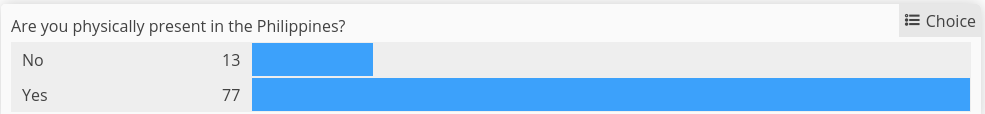
Are you physically present in the Philippines?
While 86% of the mappers reported that they are physically in the country, mappers coming from elsewhere at 14% was bigger than I expected.
Which of the following best describe your primary undertaking in the OSM project?
Posted by Raquel Dezidério Souto on 16 March 2024 in Portuguese (Português).
Last updated on 15 April 2024.
..
Posted by Raquel Dezidério Souto on 16 March 2024 in English.
Last updated on 30 April 2024.
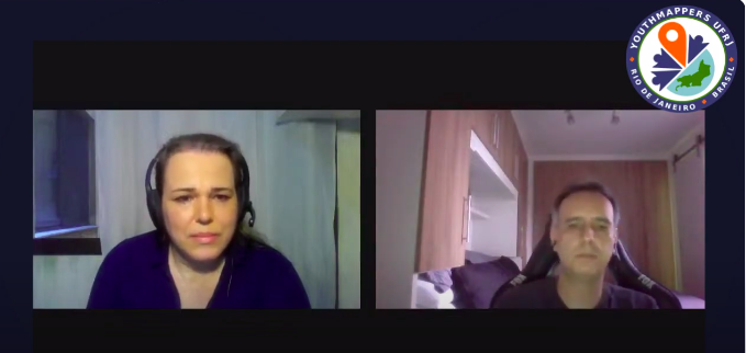
🍾 YouthMappers UFRJ celebrates its first year!
The YouthMappers UFRJ (Rio de Janeiro, Brasil) completed one year on March 14th, 2024.
And to celebrate this special date, we interviewed Dr. Rogério Luís R. Borba, analyst at the IBGE Foundation and manager of the Brazilian Geospatial Data Directory (“Diretório Brasileiro de Dados Geoespaciais, DBDG) of the Brazilian National Spatial Data Infrastructure (“Infraestrutura Nacional de Dados Geoespaciais”, INDE).
🎥 Watch on IVIDES.org’s YouTube channel.
Rogério talked to us about the importance of open data and how the collaborative mapping can helps Brazil in the production of official cartographic data. The interview was conducted by Dr. Raquel Dezidério Souto and all details can be found at: